QGIS 3.10 pakeitimai
Laidos data: 2019-10-25
QGIS 3.10 suteikia didžiulį skaičių naujų pakeitimų ir daug esamų savybių patobulinimų - apie svarbiausius iš kurių parašysime čia. Kaip visada, mes primename, kad QGIS yra atviro kodo projektas, jei galite, apsvarstykite galimybę mus paremti per įnašus, rėmimą ar pagalbą dokumentuojant kodą, svetainę ir pan.
Ačiū
Mes norėtume padėkoti vystytojams, dokumentacijos rašytojams, testuotojams ir visiems kitiems, kurie savanoriškai skyrė laiką ir pastangas (arba skyrė lėšų, kad tai būtų padaryta). QGIS bendruomenė tikisi, kad jums patiks ši laida! Jei norite skirti laiko, pinigų ar kitaip prisidėti prie to, kad QGIS būtų dar puikesnis, prašome užsukti į qgis.org ir padėti!
QGIS palaiko rėmėjai ir palaikantys nariai. Dabartinių rėmėjų, daugiau ar mažiau prisidėjusių finansiškai prie projekto, sąrašą rasite rėmėjų sąraše. Jei norėtumėte tapti oficialiu palaikymo nariu, prašome apsilankyti mūsų rėmėjų puslapyje, kur rasite daugiau informacijos. QGIS palaikymas leidžia mums finansuoti kas du metus vykstančius vystytojų susitikimus, palaikyti projekto infrastruktūrą ir finansuoti klaidų taisymo pastangas. Pilną palaikymo narių sąrašą rasite žemiau - mūsų pačios didžiausios padėkos visiems mūsų rėmėjams!
QGIS yra atvira programinė įranga ir jums jokiu būdu neprivalu mokėti norint ją naudoti. Priešingai, mes norime skatinti kiek galima daugiau žmonių naudoti ją nepriklausomai nuo jūsų finansinio ar visuomeninio statuso - mes tikime, kad duodant žmonėms įrankius, teikiančius galimybę daryti erdvinius sprendimus, galima sukurti geresnę visos žmonijos visuomenę.
Įrankiai
Savybė: identifikavimo įrankių rezultatai rodo 3D linijų ilgius
Naudojant geoobjektų identifikavimo įrankį su 3D liniją dabar rezultatuose parodys ir linijos 3d dekarto ilgį (kartu su esamu 2D dekarto ir 2D elipsoido ilgiais).
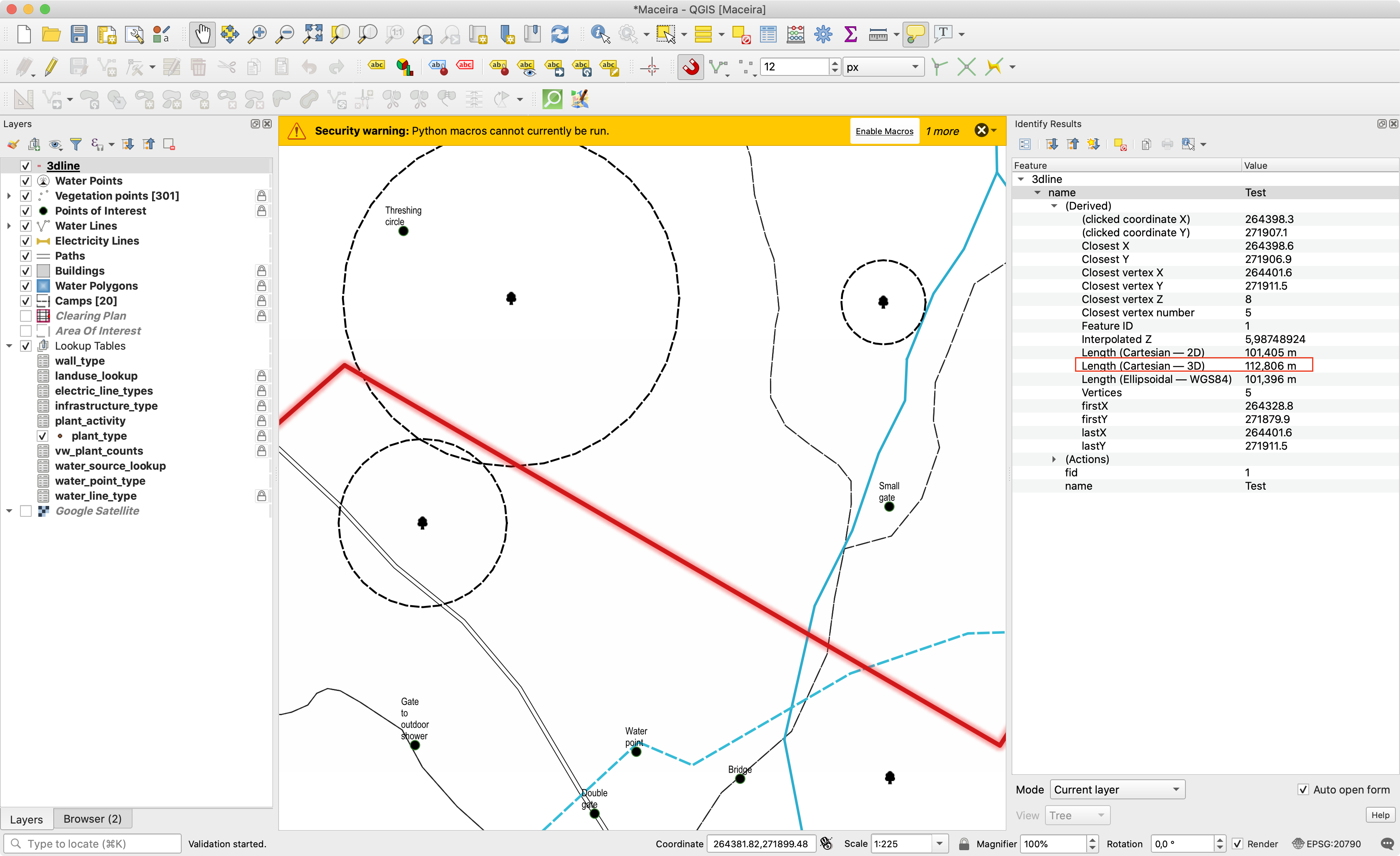
Šią savybę finansavo North Road
Šią savybę sukūrė Nyall Dawson (North Road)
Simbologija
Savybė: numatytasis perdėstymo nustatymas naujai pridėtiems rastro sluoksniams
QGIS 3.10 pridėtas naujas nustatymas numatytajam perdėstymo režimui, kuris turi būti naudojamas, kai pridedamas naujas rastro duomenų rinkinys. (Šį nustatymą galima rasti parinkčių dialogo braižymo skydelyje).
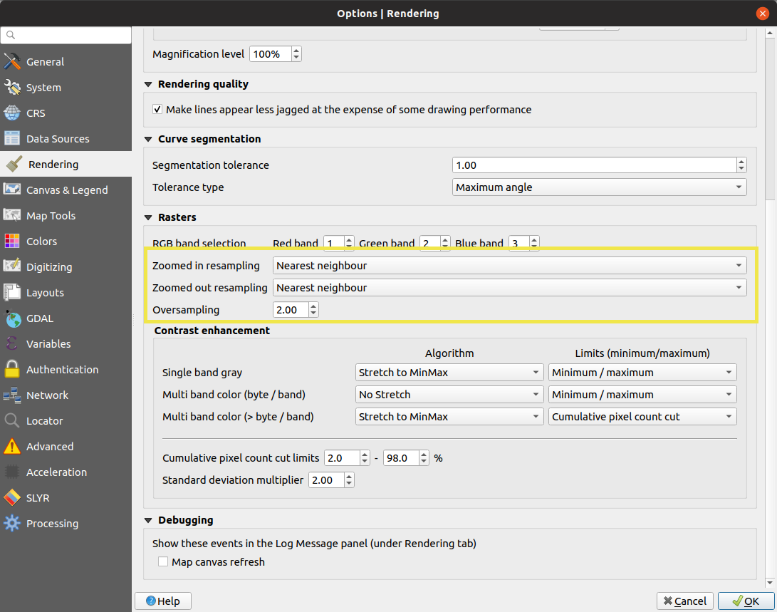
Šią savybę sukūrė Mathieu Pellerin
Savybė: pagerintas simbolių kopijavimas/įkėlimas
Mes aistringai siekiama padaryti QGIS naudotojams draugišku kartografijos įrankiu, kurį naudoti ir su kuriuo dirbti yra malonu, todėl mes visoje sąsajoje pridėjome keletą naujų klavišų kombinacijų, kurios leidžia kopijuoti ir įkelti simbolius iš vienos QGIS vietos į kitą. Pavyzdžiui jūs galite kopijuoti simbolį iš kategorijos ir įkelti jį tiesiai į kitą kategoriją arba išdėstymo formos elementą, arba stilių tvarkyklės dialogo viduje!
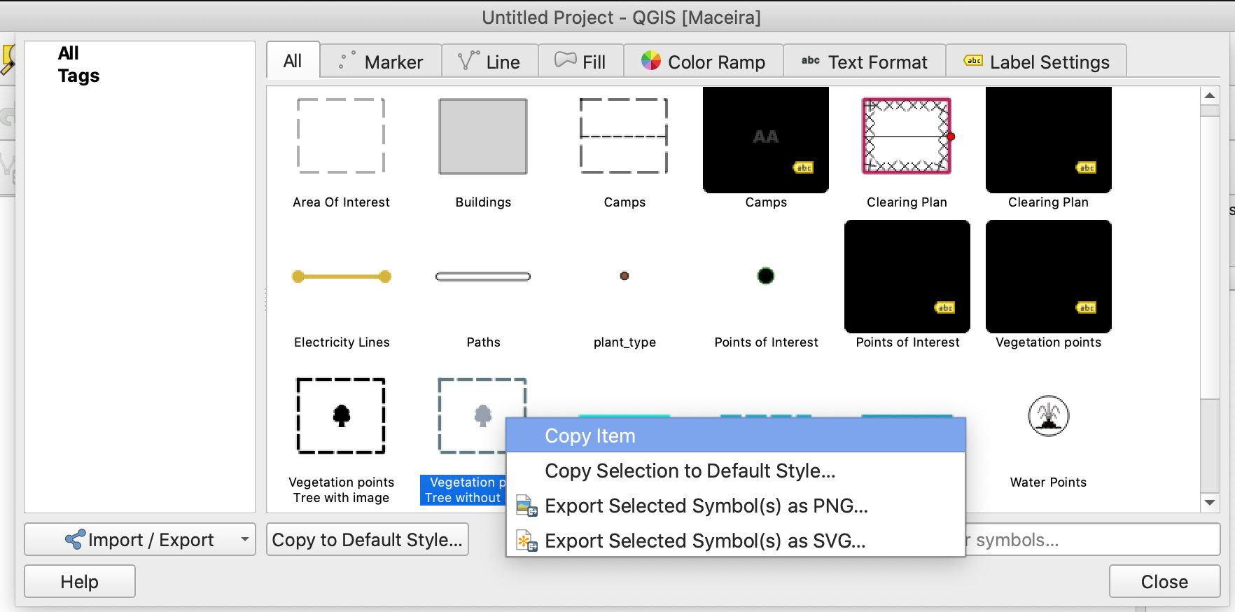
Šią savybę finansavo SMEC/SJ
Šią savybę sukūrė Nyall Dawson (North Road)
Savybė: žymeklių ir punktyrinių linijų simbolių sluoksnių pozicijos režimas „segmento centras“
Mes pridėjome visiškai naują režimą „Segmento centras“, skirtą žymeklių ar punktyrų linijų simbolių vietoms. Tai leidžia padėti žymeklius ar punktyrų linijas virš individualių linijų segmentų centro taškų, taip sukuriant kartografinius efektus, kurie anksčiau nebuvo galimi (ir pagerinant kokybę sluoksnių, kurie buvo konvertuoti iš ArcMap naudojant įrankį SLYR).
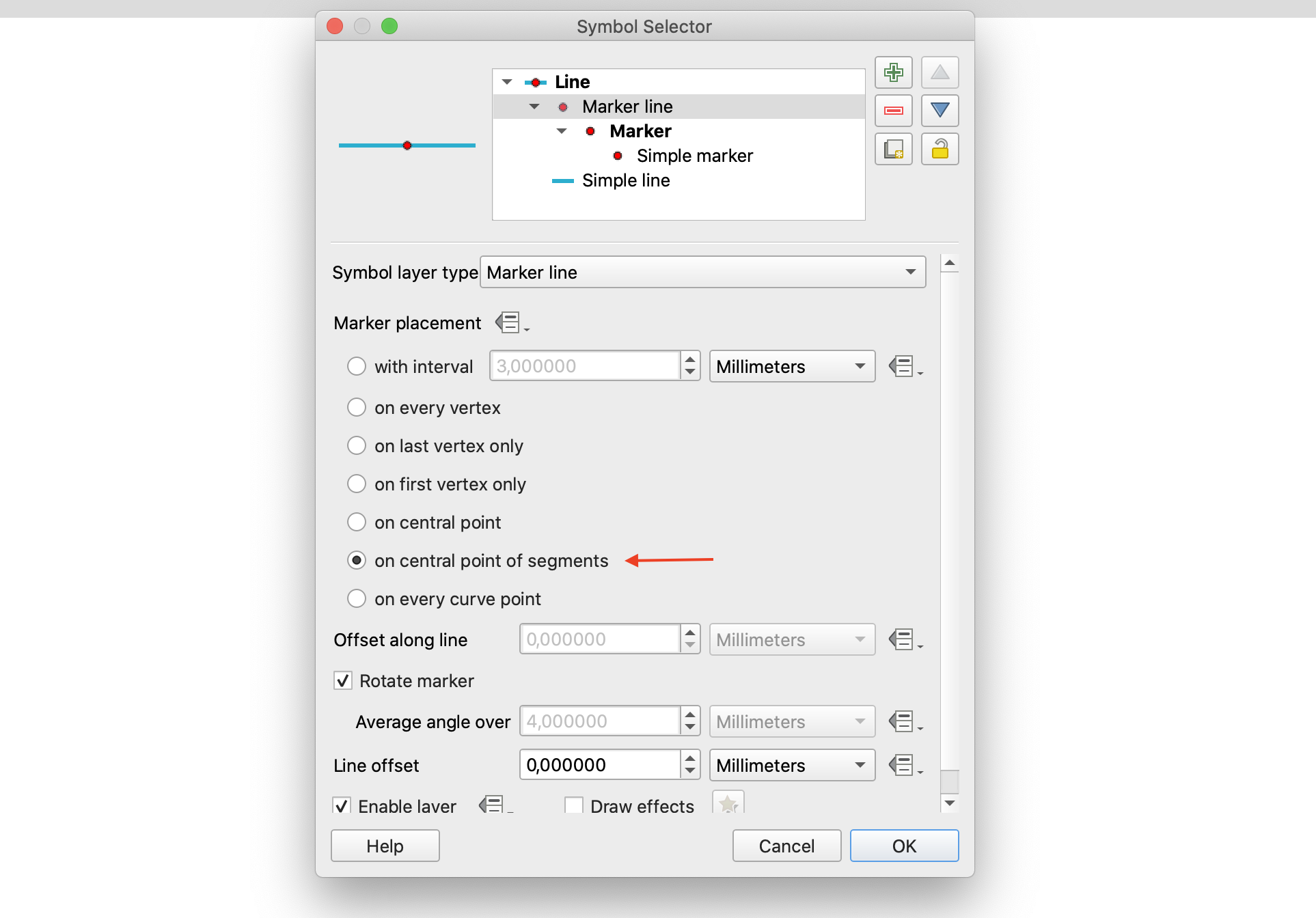
Šią savybę finansavo North Road
Šią savybę sukūrė Nyall Dawson (North Road)
Savybė: lankstesnės nuo duomenų priklausančių poslinkių išraiškos
Ankstesnėse QGIS versijose, nuo duomenų priklausantiems simboliams ir užrašų poslinkiams buvo galima naudoti tik reikšmes su formatu „x,y“. Mes įsiklausėme į naudotojų atsiliepimus, kad tai neaišku, ir QGIS 3.10 dabar leidžia pateikti skaičių masyvus kaip tinkamą poslinkio rezultatą. Pvz. „array(3,5)“.
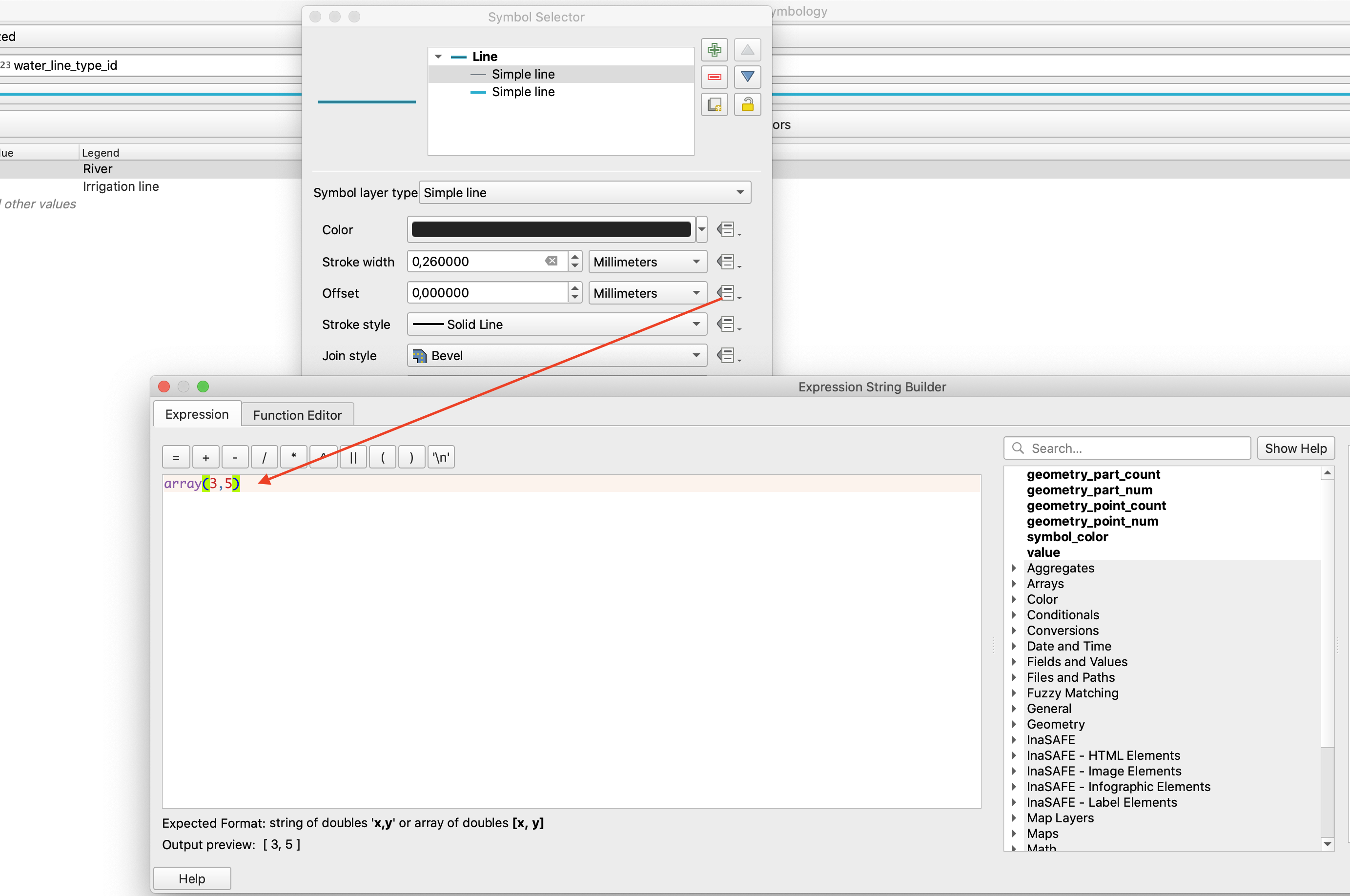
Šią savybę finansavo North Road
Šią savybę sukūrė Nyall Dawson (North Road)
Užrašai
Savybė: kurti ir tvarkyti teksto formatus ir užrašų nustatymus QGIS stiliuose
QGIS 3.10 mes pagaliau pridėjome ilgai lauktą savybę, leidžiančią naudotojams tvarkyti savo teksto formatų ir užrašų nustatymų bibliotekas kartu su jau esamomis simbolių bibliotekomis!
Dabar Stilių valdymo dialogą galima naudoti norint tvarkyti teksto formatus (kuriuose laikomas šriftas, spalva, buferiai, šešėliai ir fonai) ir sluoksnio lygio užrašų nustatymus. („Teksto formate“ yra tik šrifto nustatymai ir kiti su išvaizda susiję nustatymai, o „užrašų nustatymuose“ taipogi yra sluoksnio tipo specifiniai nustatymai, tokie kaip užrašų pozicija, prioritetas ir braižymo nustatymai).
Teksto formatai ir užrašų nustatymai suteikia tokį patį funkcionalumą, prie kurio jūs pripratę tvarkant simbolius ir spalvų rampas, įskaitant importą ir eksportą į XML failus, žymas, išmanias grupes, mėgstamus ir pan…
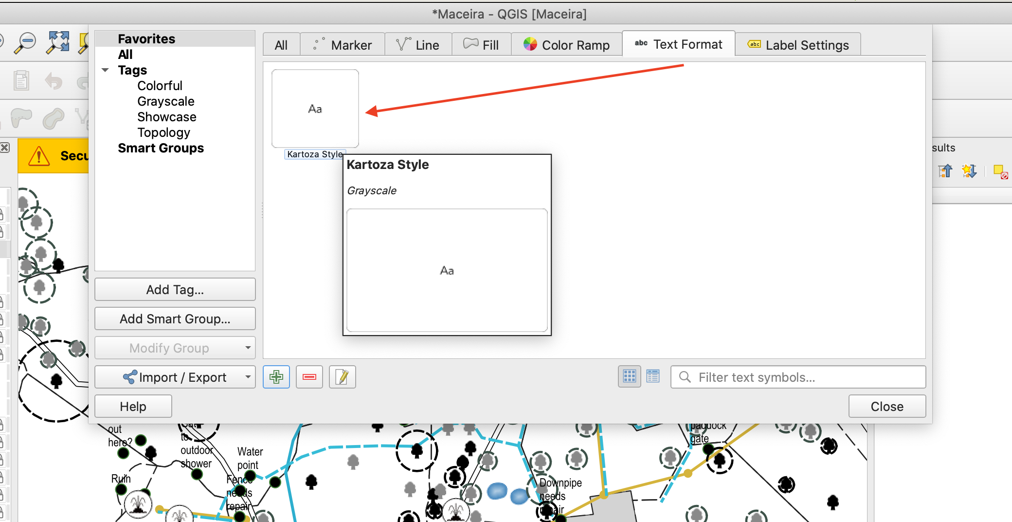
Šią savybę finansavo North Road
Šią savybę sukūrė North Road
Savybė: žymeklių simboliai kaip užrašų fonai
Kartu su kitais įspūdingais užrašų pagerinimais, atsiradusiais 3.10, mes dabar leidžiame naudoti žymeklių simbolius kaip užrašų fonus. Tai leidžia jums naudoti visą turtingą žymeklių simbolių funkcionalumą kaip užrašų foną, tai papildo esamus formų ir SVG fonų pasirinkimus!
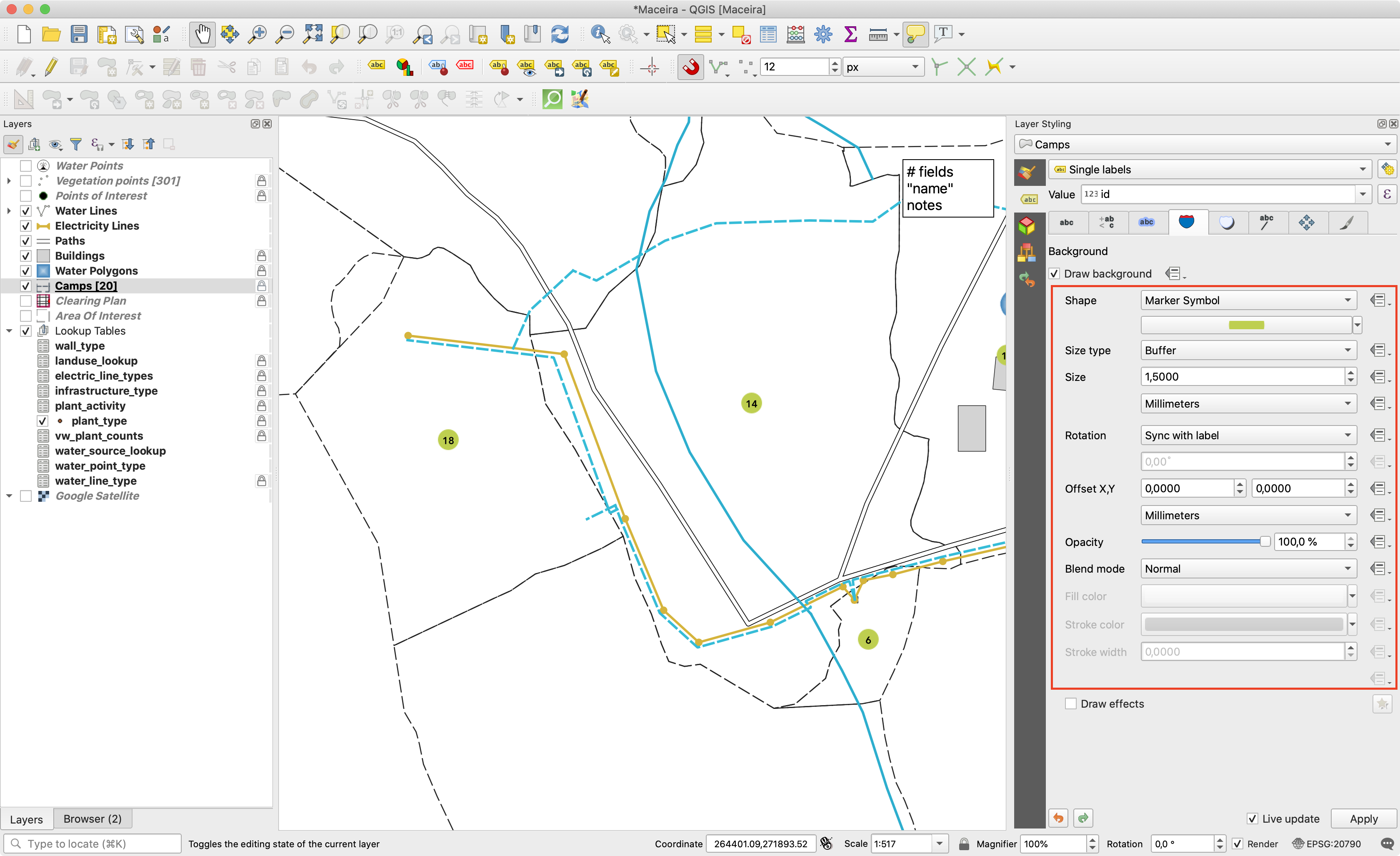
Šią savybę finansavo North Road
Šią savybę sukūrė North Road
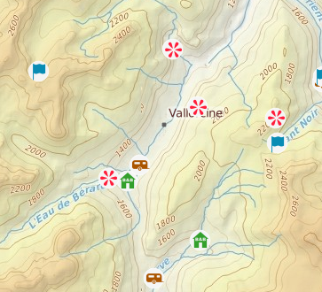
Savybė: užrašų išnešimai!
Dažna praktika dedant užrašus stipriai užpildytame žemėlapyje yra naudoti „išnešimus“ - užrašus, kurie yra padėti toliau (ar patraukti) nuo jų susijusių geoobjektų su linija, kuri jungia užrašą ir geoobjektą. QGIS 3.10 mes pridėjom savą palaikymą greitai sukurti gražiai atrodančius užrašų išnešimus (daugiau nebereikia žaisti su išraiškomis ar braižyti rankomis!).
Mes pridėjome daug nustatymų, leidžiančių valdyti, kaip braižomi šie išnešimai, ir, natūraliai, jūs galite pilnai valdyti QGIS linijų simboliką jūsų išnešimuose! Tai įskaito visus esamus linijų simbolių stilius, sluoksnių efektus ir net nuo duomenų priklausančių nustatymų palaikymą!
3.10 mes pridedame galimybę pasirinkti „paprastą“ (tiesioginę liniją) arba „Manheteno“ (tiesias linijas) išnešimą. Jei jums norėtumėte ateities laidose palaikyti kitus išnešimų stilius, prašome susisiekti su QGIS komanda ir sužinoti, kaip galite padėti tam įvykti!
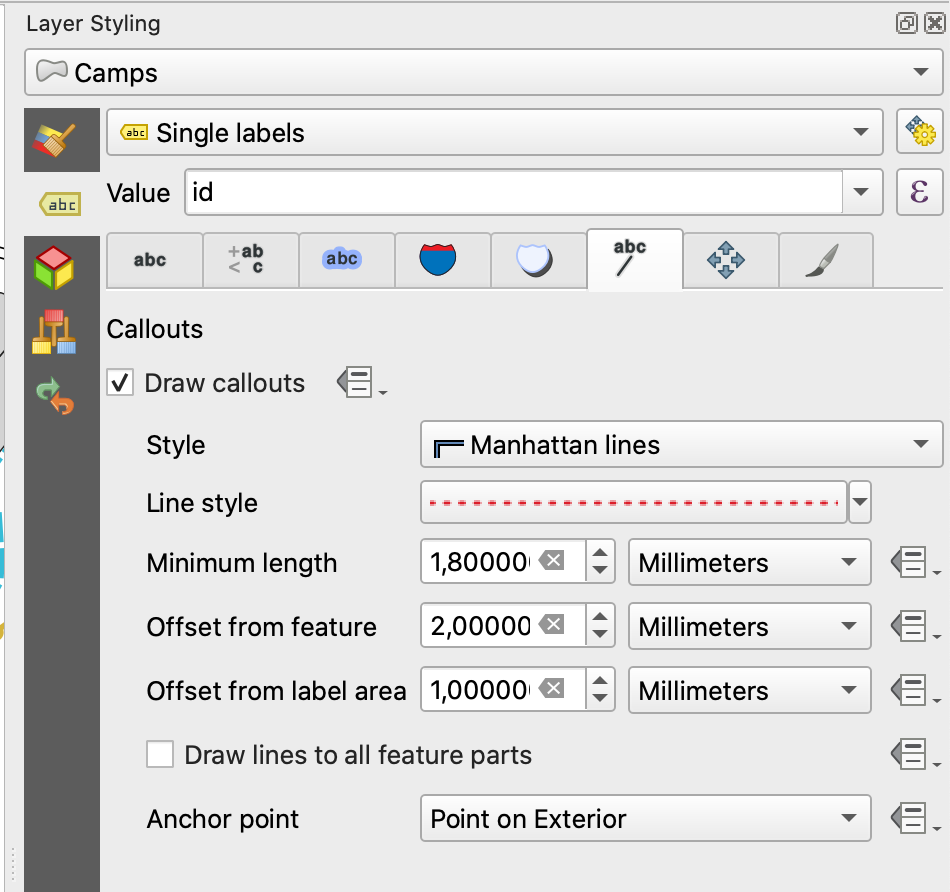
Šią savybę finansavo SMEC/SJ
Šią savybę sukūrė Nyall Dawson (North Road)
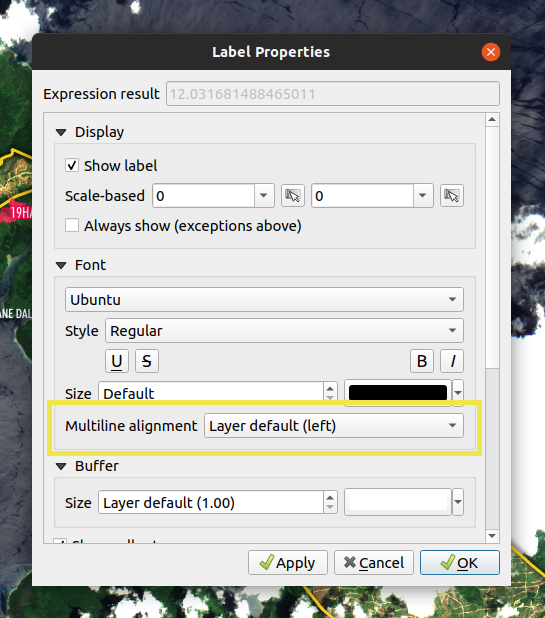
Savybė: keisti kelių linijų užrašų lygiavimą konkretiems užrašams
Mes pridėjome papildomą parinktį, kuri leidžia valdyti kelių eilučių lygiavimą konkrečiam užrašui. Įjunkite užrašo savybių įrankį ir spauskite ant žemėlapio užrašų, dabar pamatysite naują teksto lygiavimo nustatymą.
Šią savybę sukūrė Mathieu Pellerin
Savybė: rodyti nepadėtus užrašus
Jei jums kada nors kėlė rūpestį tai, kad automatinis užrašų dėliojimas gali paslėpti svarbius jūsų žemėlapio užrašus - ši savybė yra jums! QGIS 3.10 pridėta galimybė rodyti žemėlapyje „Nepadėtus užrašus“, kad galėtumėte nedelsiant pamatyti, kas konkrečiai buvo paslėpta (t.y. „matyti tai, ko kiti negali“)!
Šis naujas nustatymas (kuris prieinamas per užrašų įrankinę) braižys šiuos nepadėtus užrašus raudona spalva (bet spalvą galima pakeisti projekto užrašų nustatymo dialoge). Identifikavus bet kuriuos jūsų žemėlapyje trūkstamus užrašus, mes siūlome naudoti esamus užrašų įrankius, tokius kaip „perkelti užrašą“ ar „rodyti/slėpti užrašą“, kad pertvarkytumėte jūsų žemėlapį ir reikiamus užrašus vėl parodytumėte.
Šią savybę finansavo North Road
Šią savybę sukūrė Nyall Dawson (North Road)
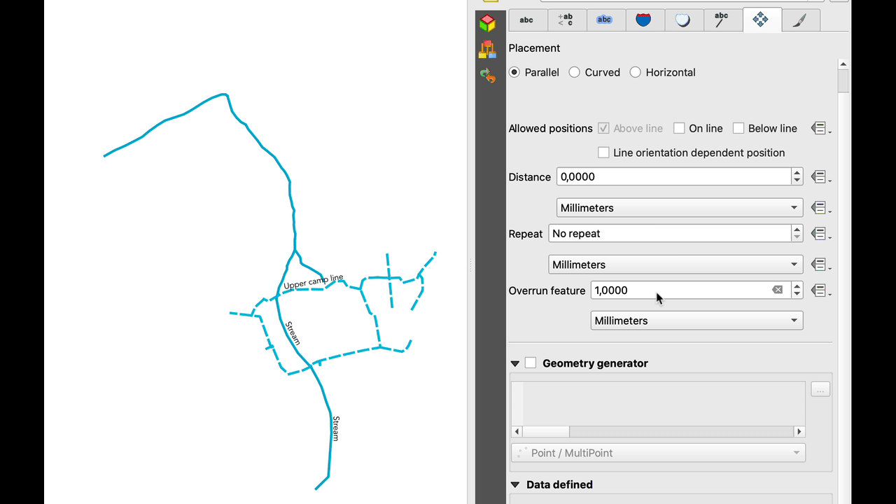
Savybė: linijinių užrašų atstumo viršijimas
Mes suprantame, kad kartografinio šedevro sukūrimas yra reikli užduotis, todėl mes QGIS 3.10 išplėtėme kreivinių užrašų galimybes, pridėdami naują „atstumo viršijimo“ nustatymą. Šis nustatymas leidžia valdyti, kiek toli linijinių geoobjektų užrašai gali išsikišti už savo ribų. Padidinus šį atstumą, užrašų dėliojimo variklis turės daugiau lankstumo dėliojant jūsų užrašus, todėl jūsų žemėlapyje bus padėta daugiau užrašų ir jų pozicijos bus geresnės! Valio! Nustatymas veikia tiek kreiviniams, tiek ir paraleliems užrašams, palaiko atstumus mm/žemėlapio vienetais/pikseliais/kt ir nuo duomenų priklausančius atstumus.
Šią savybę finansavo North Road
Šią savybę sukūrė Nyall Dawson (North Road)
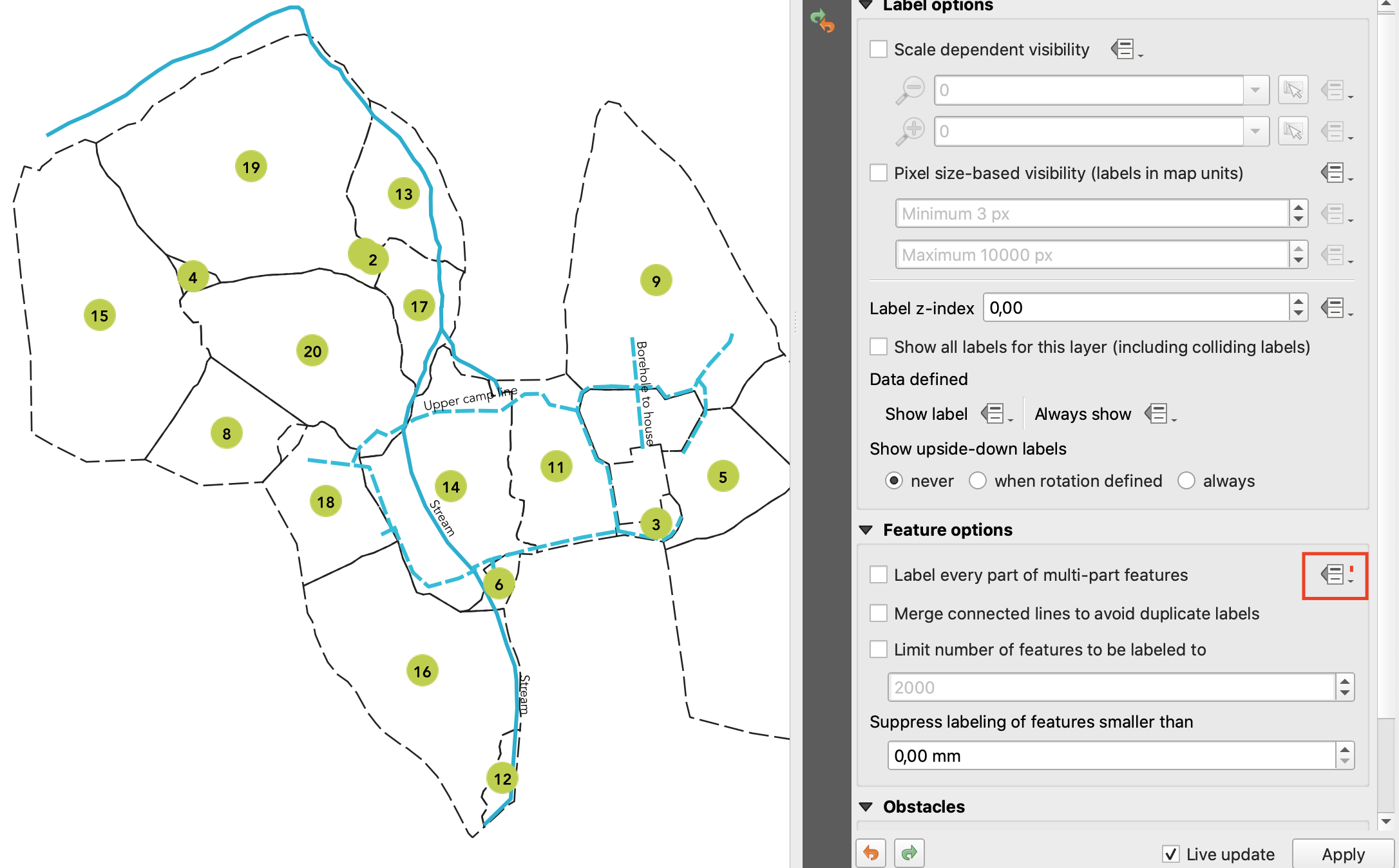
Feature: Data defined control for „label every part of multipart features“ setting
The „label every part“ option was one of the very few settings which couldn’t be previously data-definable for labels. We’ve remedied this omission in QGIS 3.10, and you can now control whether you want all parts labelled on a feature-by-feature basis!
Šią savybę finansavo North Road
Šią savybę sukūrė Nyall Dawson (North Road)
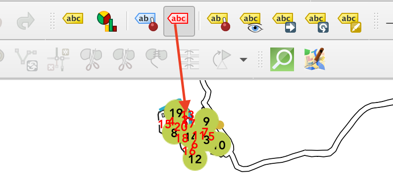
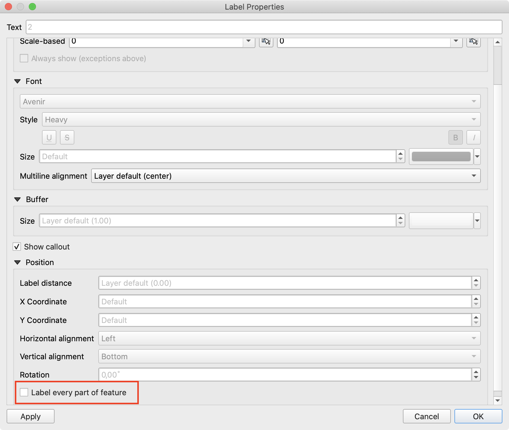
Feature: Control „label all parts“ via the label properties tool
We aren’t lying when we say that QGIS 3.10 is a love-letter to map labelling! Another new option we’ve added in this version is interactive control over whether all parts of a feature should be labeled via the Label Properties tool.
Šią savybę finansavo North Road
Šią savybę sukūrė Nyall Dawson (North Road)
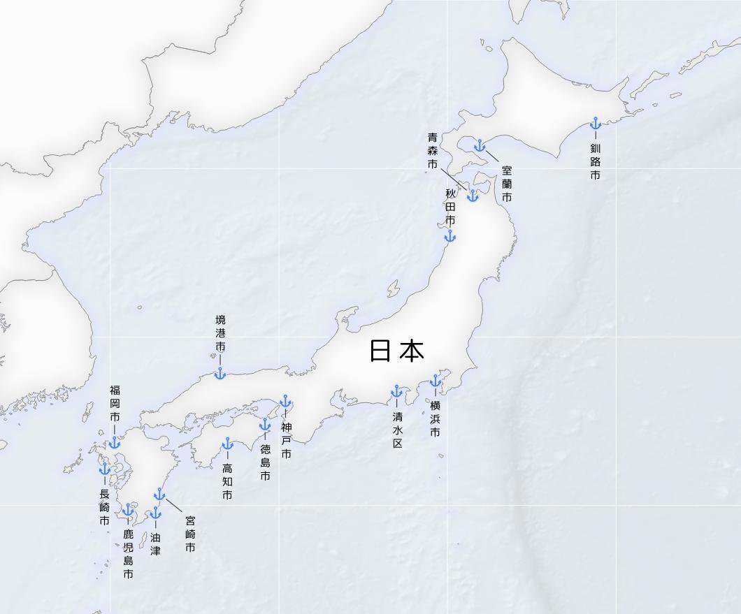
Feature: Vertical text orientation
As of 3.10, QGIS is now fully equipped to render vertically oriented labels. To our Chinese, Japanese, and Korean users: spread the word! :)
You can choose between two vertical orientation mode: one that always renders labels vertically, or an alternative mode that dynamically picks the orientation based on the label rotation.
Šią savybę sukūrė Mathieu Pellerin
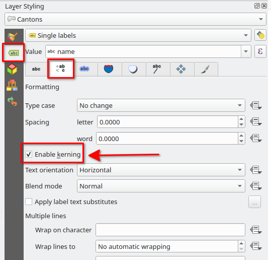
Feature: Control over font kerning
Another option we’ve added for improving the conversion of ArcMap symbology to QGIS (via SLYR) is a new setting for controlling whether label fonts are kerned (or not).
Šią savybę finansavo North Road
Šią savybę sukūrė Nyall Dawson (North Road)
Braižymas
Feature: Rendering raster layers outside the reported extent
Depending on the server technology used, sometimes the map extent reported by raster layers may be smaller than the actual area which can be rendered (especially notably for WMS servers with symbology which takes more space than the data extent). Previous version of QGIS would crop raster layers to the reported extents, resulting in truncated symbols on the borders of these layers. Now, there’s a new option to allow you to override this behaviour and ignore the reported extent for affected servers.
This feature was developed by Matthias Kuhn (Opengis.ch)
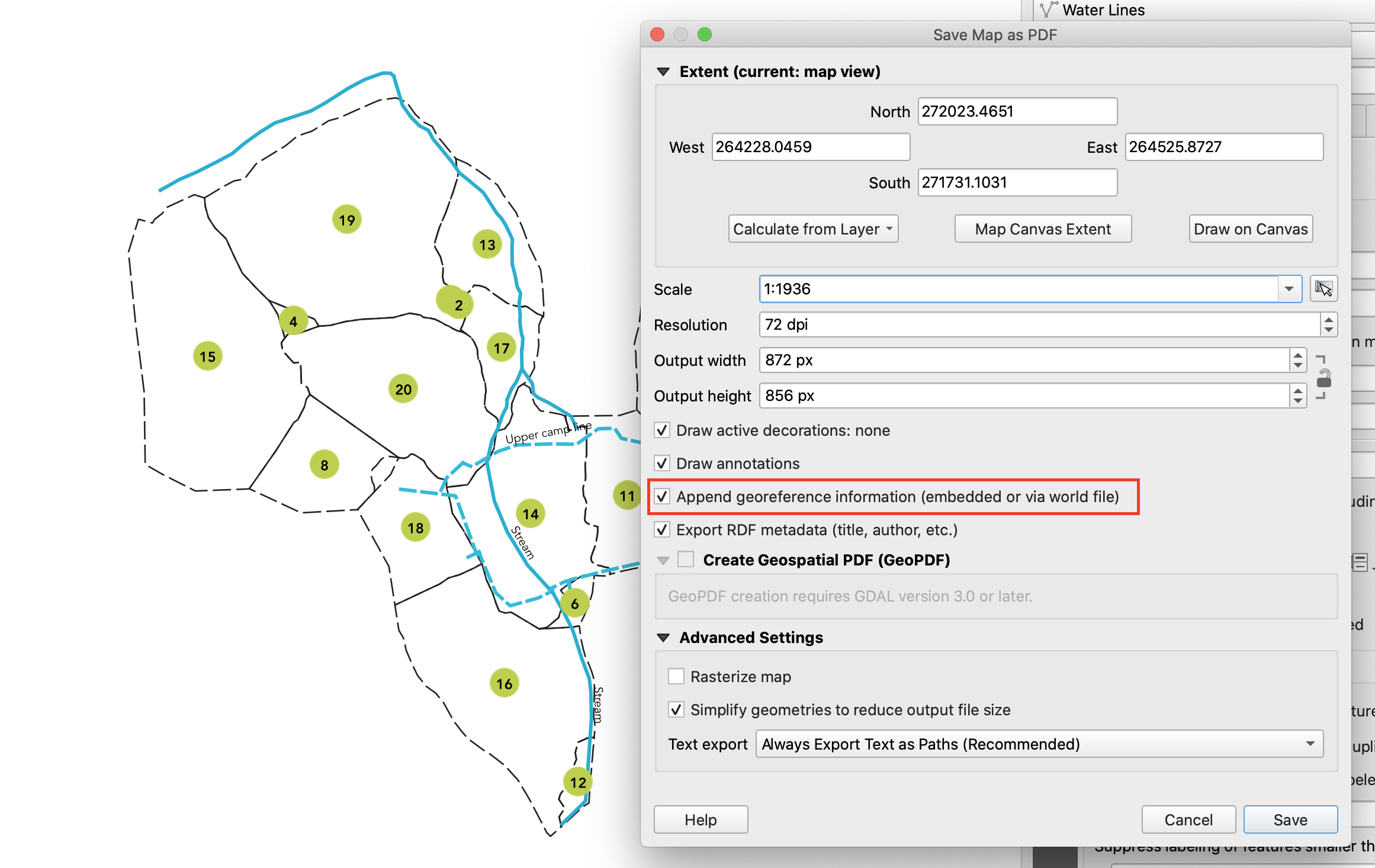
Feature: Georeference PDFs and TIFs when saving the map canvas as image/PDF
In QGIS 3.10 we’ve implemented support for embedded georeferencing within PDFs and TIFs when using the save [map canvas] as image or PDF.
Šią savybę sukūrė Mathieu Pellerin
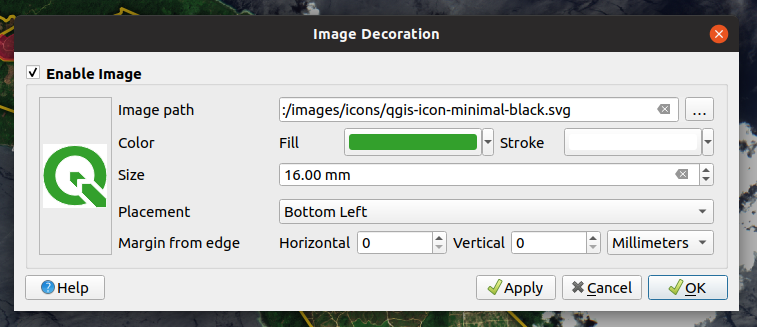
Feature: New map canvas image decoration
We’ve added a brand new decoration for the QGIS main canvas, allowing you to add a bitmap and SVG image overlay (logo, legend, etc.) to your map window.
As with other parts of QGIS, the image decoration supports customizable fill and outline color for parameter-enabled SVGs.
Šią savybę sukūrė Mathieu Pellerin
Feature: Logarithmic scale classification
You can now use a logarithmic based classification technique when creating ranges for the graduated renderer.
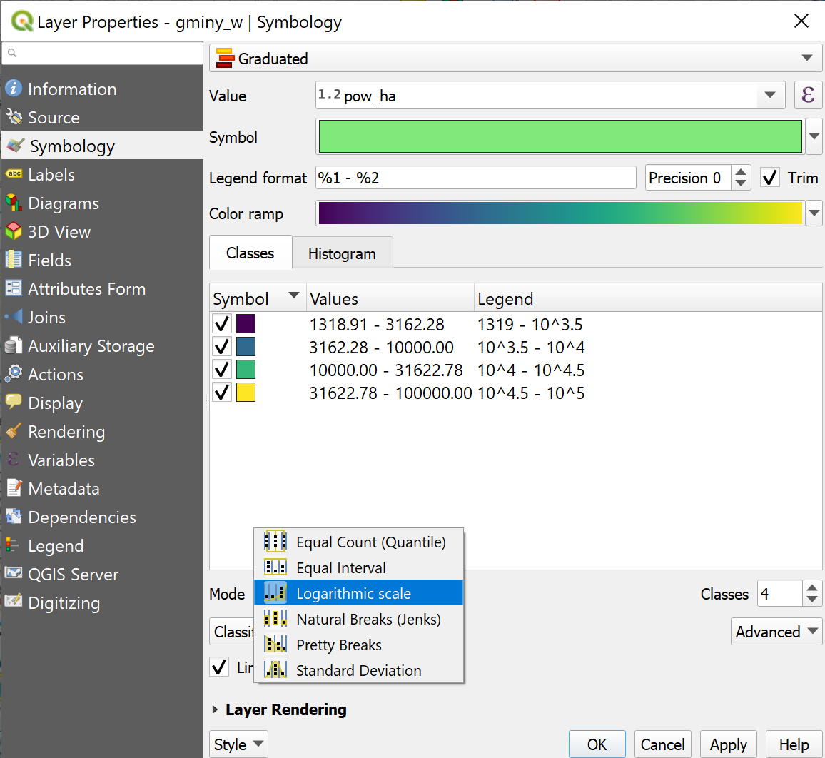
This feature was developed by OPENGIS.ch
3D savybės
Feature: Measurement tool in 3D map view
Now you can measure distances in 3D map views! This new tool is available in the 3D map view toolbar, and has the same workflow as the 2D measurement tool (with the same configuration settings of rubber band color, units, decimal place, etc). It also has the same behavior (left-click to add a new point, middle-click to delete the last point, and right-click to restart the measurement). This allows you to measure distances in 3d, e.g. the distance between two building’s roofs or the length of a river running down a mountain. See the 3D measurement tool in action:
This feature was funded by Google Summer of Code Program
This feature was developed by Ismail Sunni
Feature: Billboard Rendering for Points
We added a new kind of rendering style for point layers. It allows you to show the point with a QGIS symbol (e.g. marker, SVG, etc) that always faces the user and always has the same size. You can see sample usage in the video.
This feature was funded by Google Summer of Code Program
This feature was developed by Ismail Sunni
Feature: 3D On-Screen Navigation
In earlier QGIS versions, you could already navigate the 3D world by using a mouse and keyboard. Unfortunately, for a new user, it is not easy to start using them! 3D On-Screen Navigation will help to navigate the 3D world. There are buttons to zoom in/out, tilt up/down, pan up/down/left/right, and rotate the 3D map view. This feature can be activated from the 3D map view toolbar. See how to use it in this video:
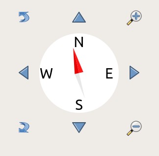
This feature was funded by Google Summer of Code Program
This feature was developed by Ismail Sunni
Spausdinimo maketai
Feature: Right-to-left arrangement for legends
Thanks to funding from our right-to-left locale users, we’ve added a new choice for arrangement of legend elements. These include symbols to the left OR symbols to the right of the legend text, and alignment options for groups, subgroups and item text.
This feature allows creation of right-to-left locale friendly legends. To make things user-friendly, we even default to this right-to-left style alignment when creating new legends under a RTL based locale.
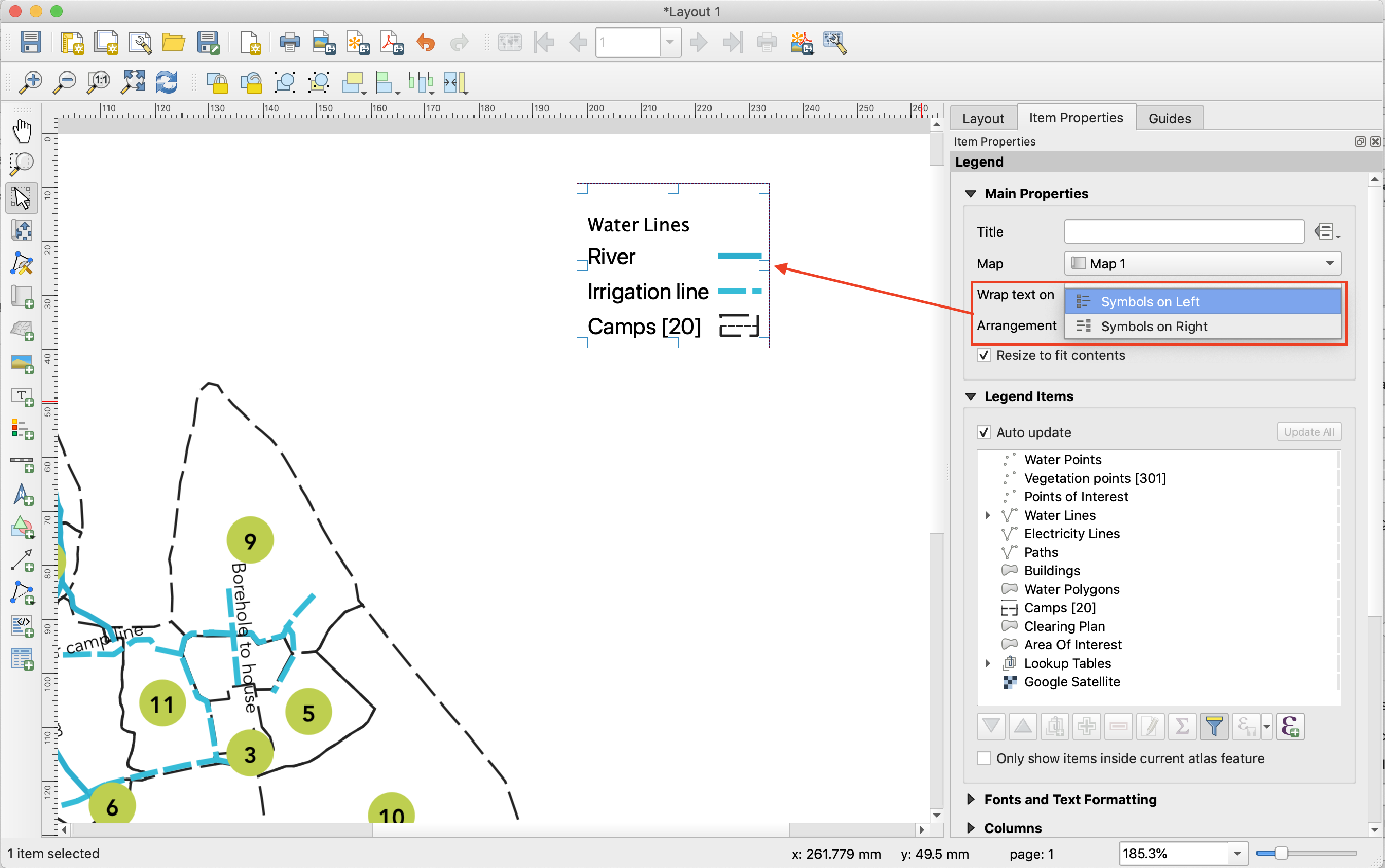
This feature was funded by Kaplan Open Source
Šią savybę sukūrė Nyall Dawson (North Road)
Feature: Control margin under legend group and subgroup headings
If you’re after pixel-perfect control over your legend appearance – this one’s for you! QGIS 3.10 now allows you to tweak the spacing applied under group or subgroup headings.
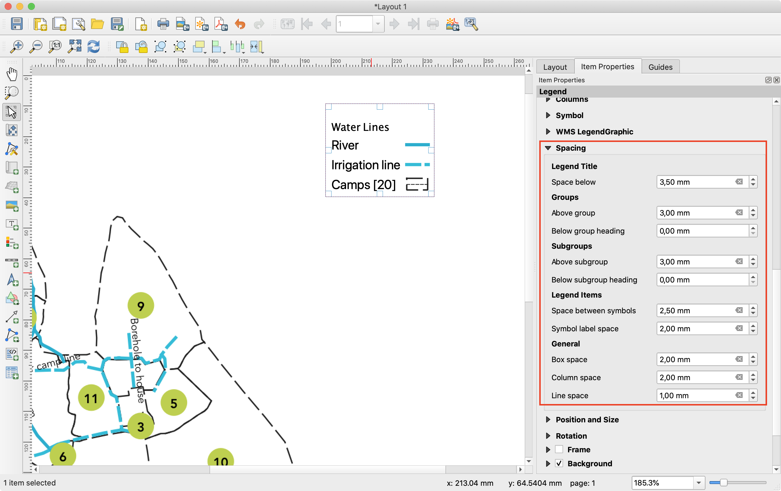
Šią savybę finansavo North Road
Šią savybę sukūrė Nyall Dawson (North Road)
Feature: Data defined settings in text formats
Since so much of QGIS‘ cartographic power comes from the flexibility of data-defined symbol settings, we’ve now allowed them to be used for text formats too! This means you can now use data defined properties wherever text formats are used, e.g. within layout scalebar text.
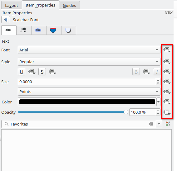
Šią savybę finansavo North Road
Šią savybę sukūrė Nyall Dawson (North Road)
Feature: @scale_value variable
To complement the new support for data-defined settings within text formats, we added a new @scale_value expression variable. This can be used when evaluating data defined text format properties while rendering scale bar text, and ultimately allows you to have per-label customisation of the text format inside scale bars (e.g. showing certain distance labels in bold).
Šią savybę finansavo North Road
Šią savybę sukūrė Nyall Dawson (North Road)
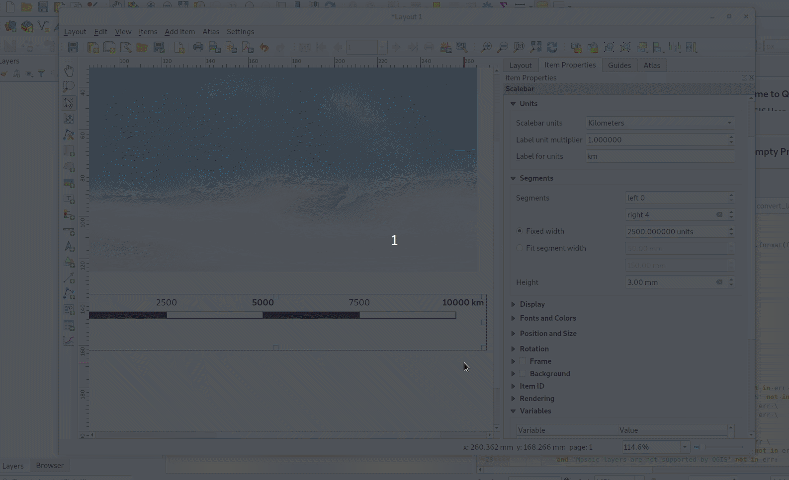
Feature: Scalebar label placement options
We’ve extended layout scale bars with additional styling options, adding a pair of settings to refine the placement of scalebar labels. Now you can define whether labels are shown above or below the scalebar itself, as well as setting whether labels are centered in the middle of a segment or placed at its end.
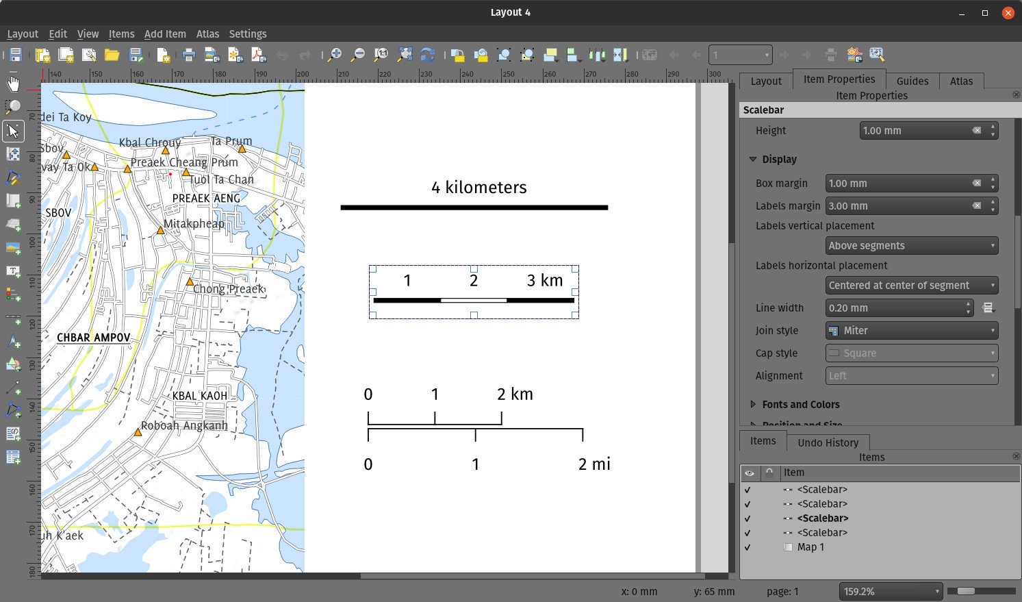
Šią savybę sukūrė Mathieu Pellerin
Feature: Simplify PDF or SVG exports
Previous QGIS versions would often generate HUGE PDF (or SVG) outputs, as these outputs included many redundant vertices which were not discernably different at the export DPI. Now, by default, we apply a simplification while writing out PDF or SVG files, causing geometries to be simplified and automatically removing any redundant vertices which are (e.g. if export DPI is 300 dpi, vertices less then 1/600 inch different from each other will be removed).
This new setting, „Simplify geometries to reduce output file size“, is exposed in the SVG or PDF export settings dialogs shown when exporting a layout/atlas/report to PDF or SVG.
No more ridiculously complex and large export file size for your QGIS print layouts! Aside from the file size issues, these also cause problems when trying to load into other applications, e.g. Inkscape, which chokes on the huge number of vertices and grinds to a crawl…. ouch!
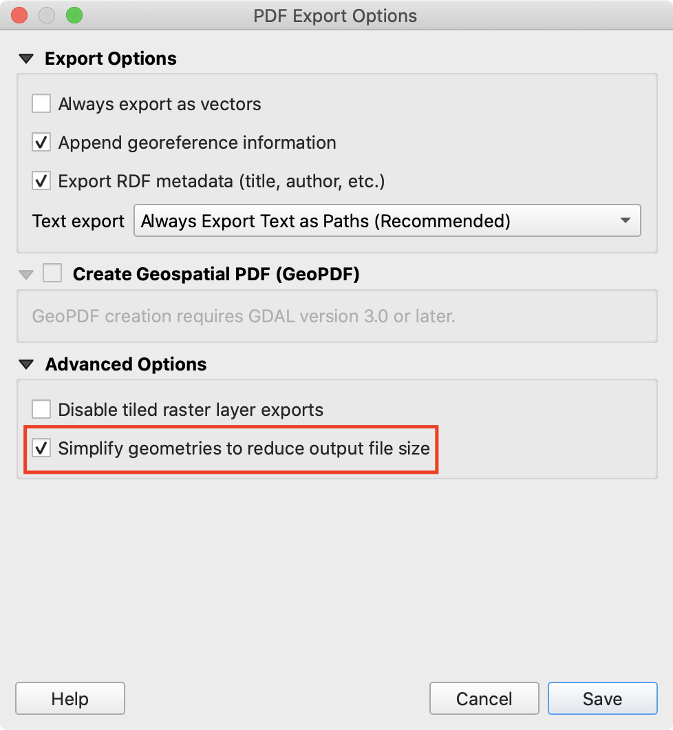
This feature was funded by GeoPDF export group: Land Vorarlberg; Cantons of Zug, Thurgovia and Neuchâtel; Cities of Vienna and Dornbirn; Biodiversity Information Service for Powys & Brecon Beacons National Park
Šią savybę sukūrė Nyall Dawson (North Road)
Feature: Improved SVG layered exports
User feedback told us that the way we created layered SVG files in past releases was frustrating to work with. So, in QGIS 3.10, we’ve revamped this feature and now SVG layer names will match the layer names from QGIS, making it much easier for designers to understand the contents of the document! Read more about this are related features here.
This feature was funded by GeoPDF export group
Šią savybę sukūrė Nyall Dawson (North Road)
Feature: Layout map redraw indicator
In earlier QGIS releases, there was no way to tell whether a map refresh had finished inside a QGIS print layout designer window. So, we’ve added a new indicator in the status bar which shows whenever there’s a redraw is humming away in the background. No more user confusion!
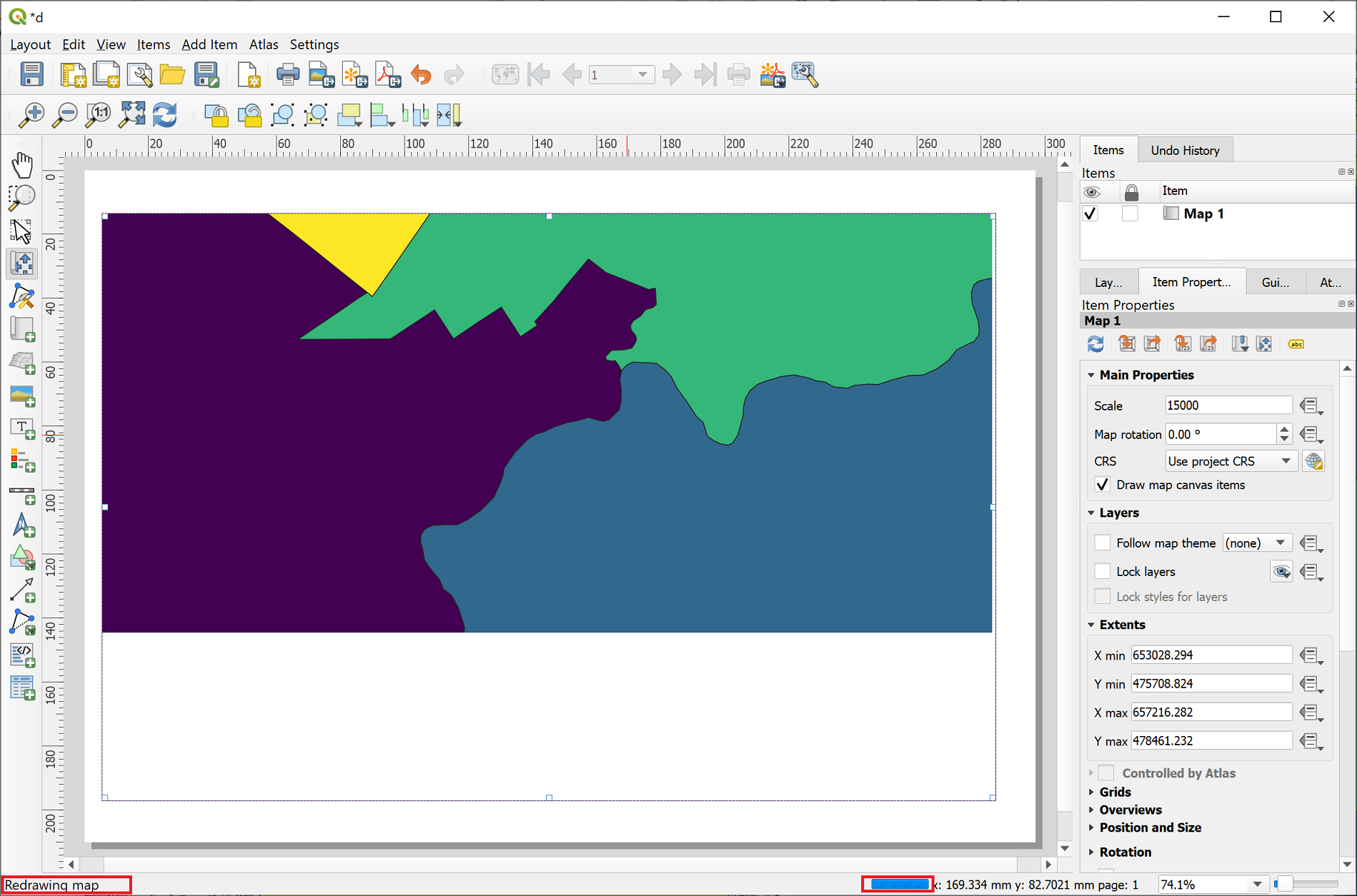
Šią savybę finansavo North Road
Šią savybę sukūrė Nyall Dawson (North Road)
Feature: GeoPDF Export
If you export PDF’s from QGIS now, there is an option to export it as GeoPDF. If you open this PDF with a compatible PDF viewer, you will then be able to toggle layers on and off, pan and zoom around the PDF and interactively interrogate features! Futhermore, you can re-import these GeoPDF documents back into QGIS as vector layers, and see all the features in their original locations and with their original attribute values.
GeoPDF export is available for either print layouts or map canvas exports. We’ve added lots of flexibility to this new option, e.g. with options for controlling which layers will be exported as interactive layers. You can even choose to export multiple map themes into a single GeoPDF document, so that your readers can interactive switch between these themes! (Wow!)
Note that GeoPDF export requires a QGIS build based on GDAL 3.0 or later.
Read more at QGIS 3.10 Loves GeoPdf
This feature was funded by GeoPDF export group: Land Vorarlberg; Cantons of Zug, Thurgovia and Neuchâtel; Cities of Vienna and Dornbirn; Biodiversity Information Service for Powys & Brecon Beacons National Park
Šią savybę sukūrė Nyall Dawson (North Road)
Feature: Data defined control grid properties
We’ve added data defined control over layout map grids, to give you extra flexibility in the appearance and behaviour of these grids, and to allow you to create layout templates and atlases with grids which dynamically respond to map scale changes.
Now, you’re able to set data-defined control for:
grid enabled state
grid x/y intervals
grid x/y offsets
grid frame size and margin
annotation distances from the grid frame
grid cross size
grid frame line thickness
Šią savybę finansavo Andreas Neumann
Šią savybę sukūrė Nyall Dawson (North Road)
Feature: Dynamic grid segment sizes
Just like the existing scalebar setting of the same name, this new setting allows you to set a page-size-based range for map grid intervals. The grid interval will be dynamically calculated based on the map extent and scale to pick the largest possible „pretty“ interval which results in grid sizes inside the desired range.
This change makes it possible for you to create layouts and layout templates with grids which respond elegantly to a wide range of map scales!
Šią savybę finansavo Andreas Neumann
Šią savybę sukūrė Nyall Dawson (North Road)
Feature: Spatial bookmarks for layout maps
Another long-requested feature we’ve implemented for QGIS 3.10 is a new button in the layout map item properties toolbar, which allows you to directly set a map item to the extent of a spatial bookmark!
Šią savybę finansavo North Road
Šią savybę sukūrė Nyall Dawson (North Road)
Išraiškos
Savybė: naujos išraiškų funkcijos
attributes(): returns a map containing all attributes from a feature, with field names as map keys. We’ve got flexible, robust support for working with map values in expressions now, so this allows rapid conversion of all feature attributes to a map to use with these handy functions!
New optional „format“ parameters were added to the to_date, to_datetime, and to_time functions
- collect_geometries: this new function collects a set of geometries into a multi-part geometry object. Geometry parts can either be specified as separate arguments to the function or (more flexibly), as an array of geometry parts. This function allows geometries to be generated using iterator based approaches, such as transforming an array generated using generate_series, e.g:
collect_geometries( array_foreach( generate_series( 0, 330, 30), project($geometry, .2, radians(@element)) ) )Gives a nice radial effect of points surrounding the central feature point when used as a MultiPoint geometry generator A new make_line expression function variant which accepts an array of points. This allows creation of lines from variable numbers of points, and from sequences from aggregates/dynamically generated sequences.
Skaitmeninimas
Feature: GPS timestamp support
We’ve overhauled the existing GPS based functionality in QGIS 3.10, adding new options for automatically retrieving and storing GPS timestamps alongside GPS based features.
This feature was funded by NIWA
This feature was developed by Alessandro Pasotti (North Road)
Feature: Allowed gap exceptions
In QGIS 3.4 we introduced the ability to configure QGIS layers to run topological checks on every save operation. For 3.10, we have now added a new option to the check for „gaps“ which allows you to actively mark some gaps as allowed. These exceptions will be saved on a separate, configurable layer. Whenever a gap is detected, you either have the possibility to fix it or to add it to the allowed exceptions with the press of a button.
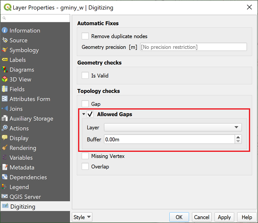
This feature was funded by Kanton Solothurn
Šią savybę sukūrė Matthias Kuhn (OPENGIS.ch)
Duomenų valdymas
Feature: Composite Foreign Keys
In QGIS 3.10, we added the possibility to create layer relationships which utilise composite foreign keys. QGIS now fully supports editing parent and child features which are linked with more than one attribute. This functionality is accessed in the Project Properties -> Relations tab.
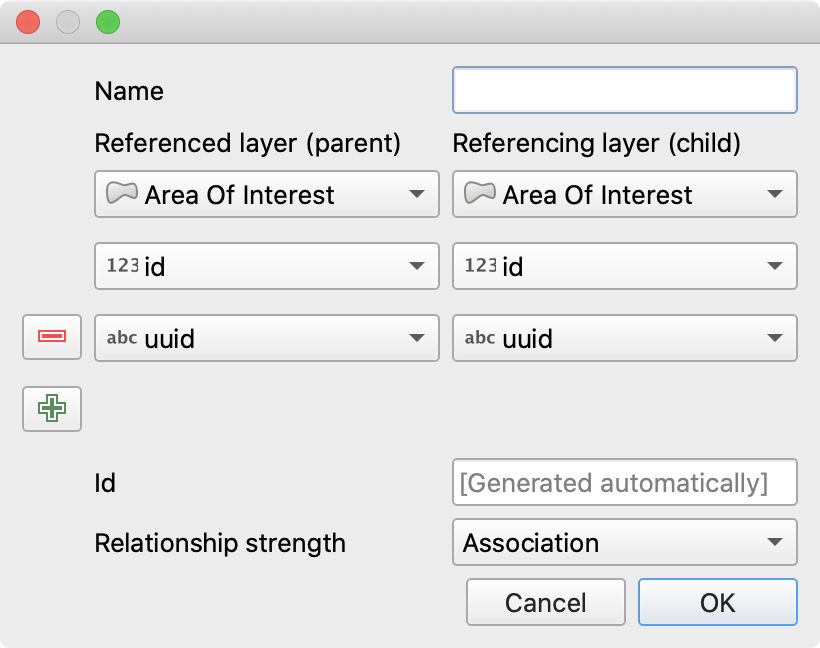
This feature was funded by California Geological Survey
This feature was developed by OPENGIS.ch
Feature: Add circular data dependencies
Ever had issues with snapping when editing a feature that is modified by someone else (or a nasty database trigger)? Data dependencies allow refreshing the content of the dependent layers when the data is changed. We improved the dependencies support in QGIS by allowing refreshing the modified layer itself, which is kind of a circular dependency (a point layer and a line layer depending on each other for instance). No more snapping on ghost features!
More info in the pull request
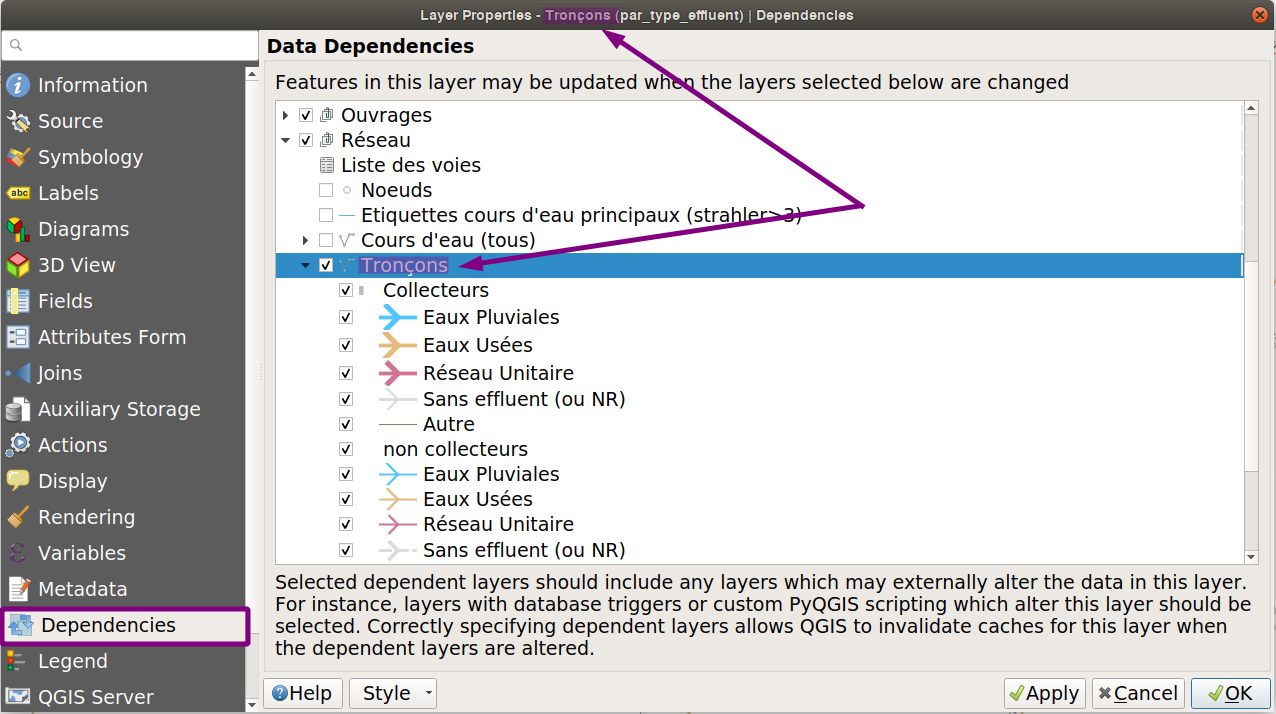
Šią savybę finansavo QGIS.org
This feature was developed by Julien Cabieces (Oslandia)
Formos ir valdikliai
Feature: Update depending widgets real-time
Updates widget values on real time while editing the referenced fields. When widget A contains a default value depending on widget B, it updates as soon as widget B is edited.
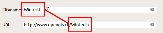
This feature was funded by Kanton Schaffhausen
This feature was developed by David Signer (OPENGIS.ch)
Analizės įrankiai
Feature: Stored filter expressions for attribute tables
While previous versions of QGIS allowed you to filter attribute tables using a custom expression, these expressions were lost whenever the attribute table was closed. Now, we’ve added the ability to store and manage your custom expression filters to the attribute table dialog. You can now build up your own personal collection of useful filters, which will always be available for re-use with a few simple mouse clicks!
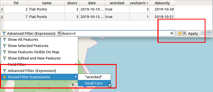
This feature was funded by Kanton Schaffhausen
Šią savybę sukūrė David Signer (OPENGIS.ch)
Feature: New operators for Raster Calculator
You ask, we listen: abs , min and max are now available in the Raster Calculator user interface!
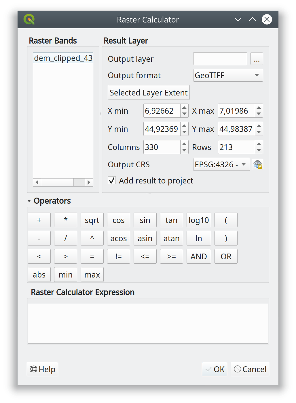
This feature was developed by Alessandro Pasotti
Apdorojimas
Feature: New algorithm „Point to layer“
This algorithm creates a new vector layer which contains a single feature with geometry matching a point parameter. It can be used in models to convert a point input into a layer, which can then be used for other algorithms which require a layer based input.
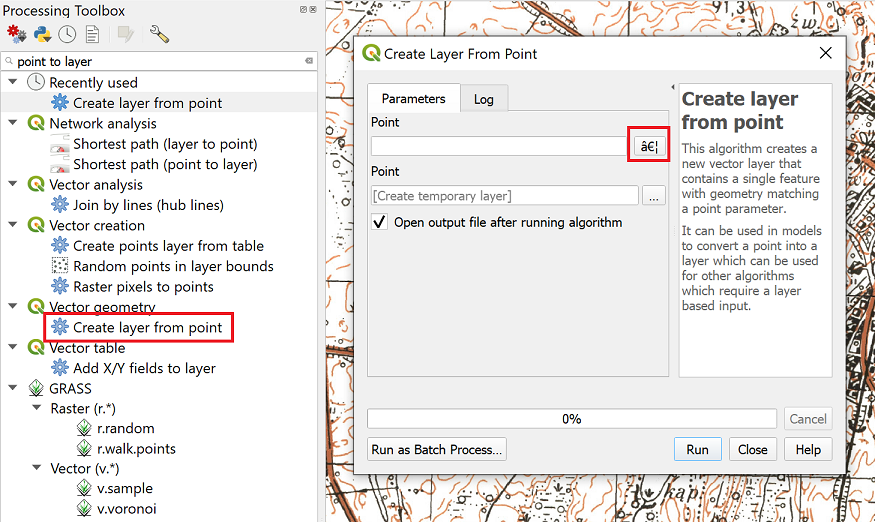
This feature was developed by Olivier Dalang
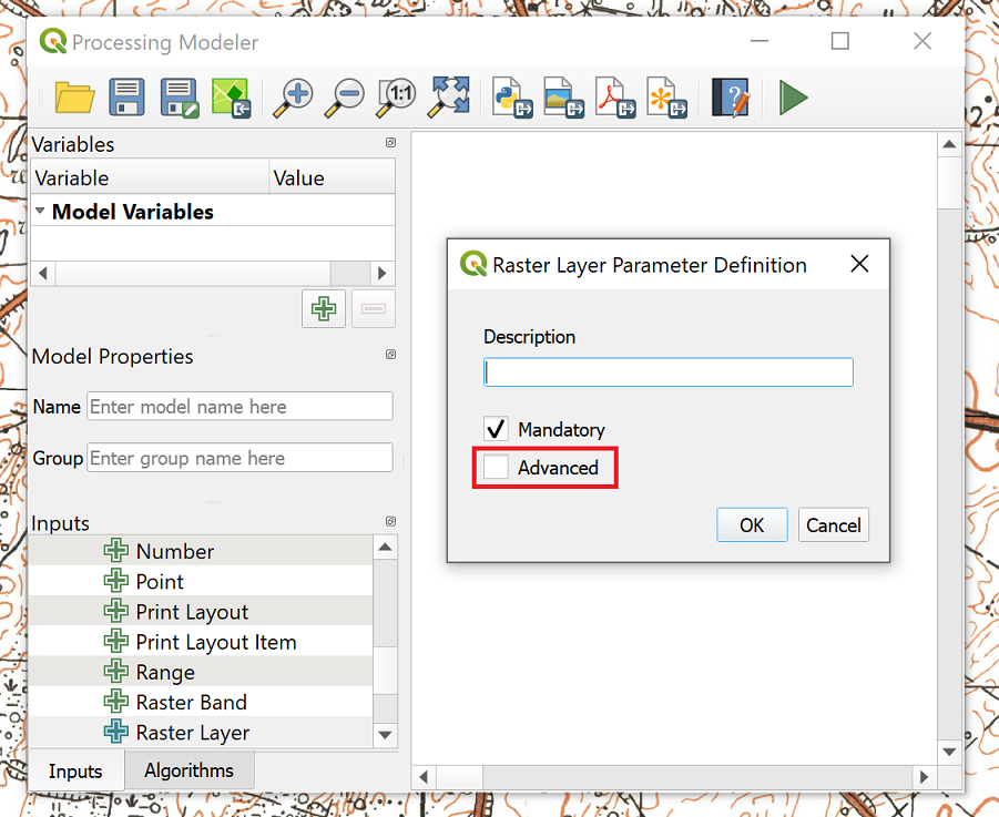
Feature: Advanced model parameters
When creating inputs for a Processing model, you can now mark these input parameters as „Advanced“ options. (Advanced parameters are hidden by default when users run your model through the Processing toolbox)
Šią savybę sukūrė Alex Bruy
Feature: All GDAL based algorithms now support free-form „additional parameters“
We added an optional „Additional command-line parameters“ parameter to all GDAL algorithms , useful for cases when you need to pass a specific command-line argument(s) which is not exposed in the algorithm UI.
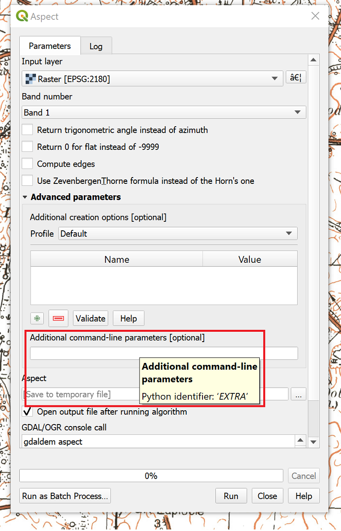
Šią savybę sukūrė Alex Bruy
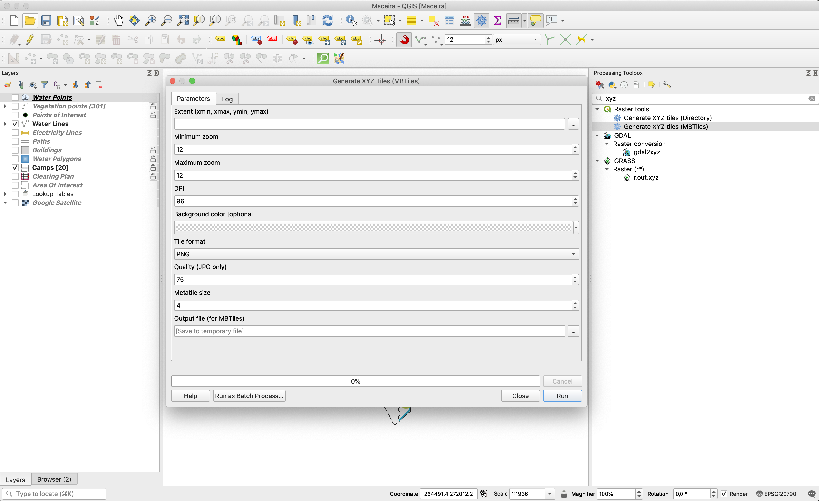
Feature: Metatile size for XYZ tiles
You can now specify a custom metatile size when generating XYZ tiles. Larger values may speed up the rendering of tiles and provide better labelling (fewer gaps without labels) at the expense of using more memory.
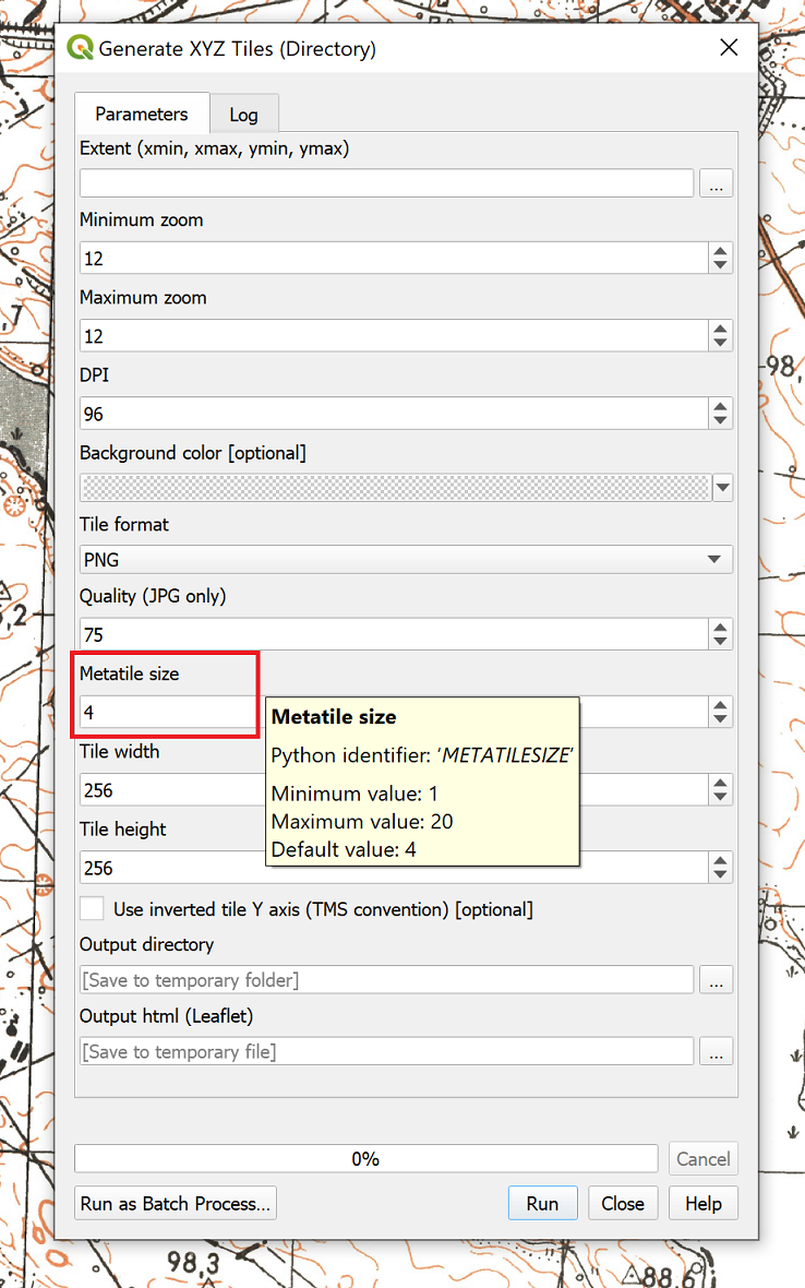
Šią savybę sukūrė Martin Dobias
Feature: New parameter type for colors
QGIS 3.10 brings a new parameter type for use in Processing models and scripts, which allows for users to pick a color value. Useful for any models and algorithms which require a color value as an input!
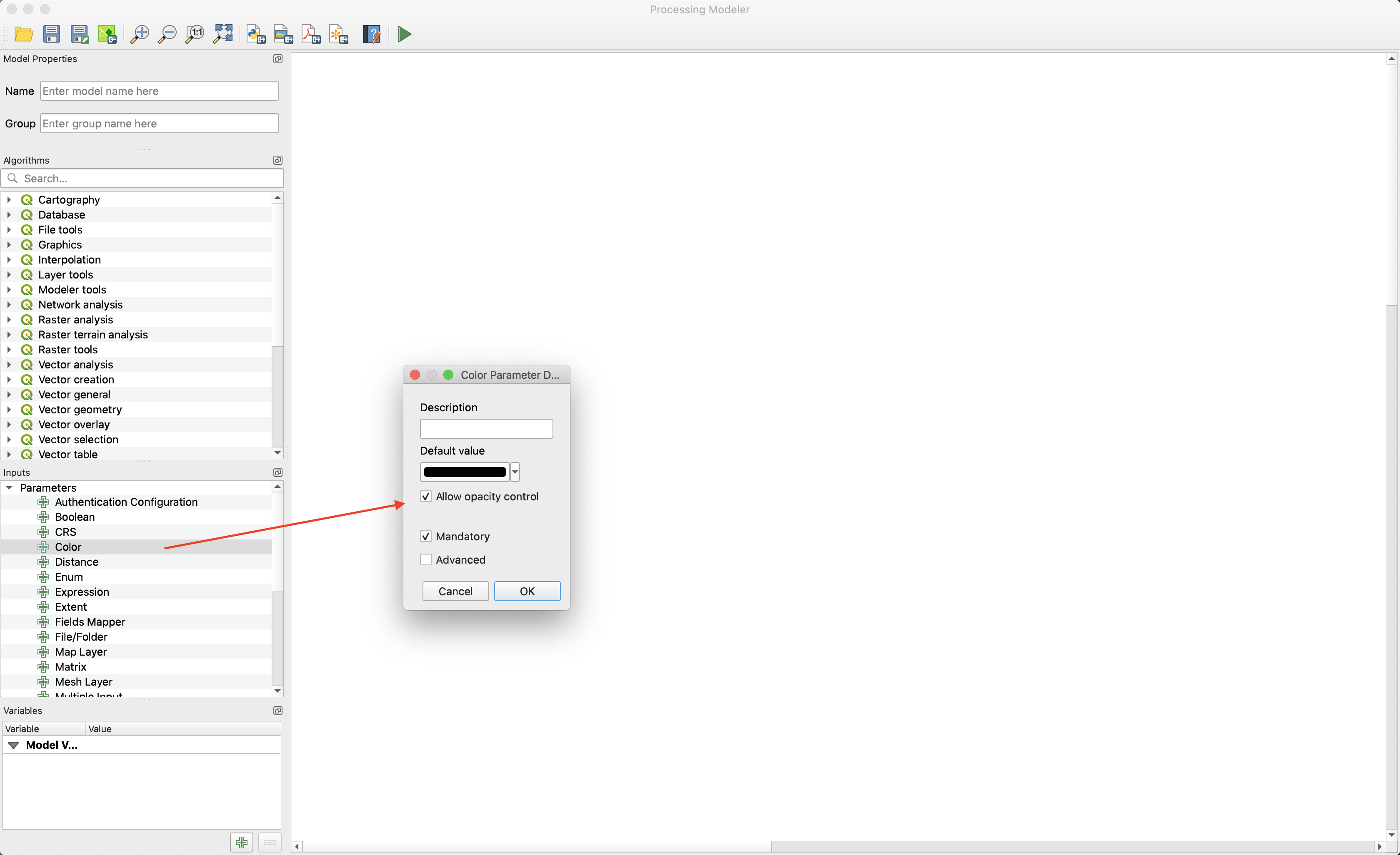
Šią savybę finansavo North Road
Šią savybę sukūrė Nyall Dawson (North Road)
Feature: New algorithm „Create style database from project“
This algorithm extracts all style objects (symbols, color ramps, text formats and label settings) from a QGIS project and stores them in a new style XML database, which can then be managed and imported via the Style Manager dialog.
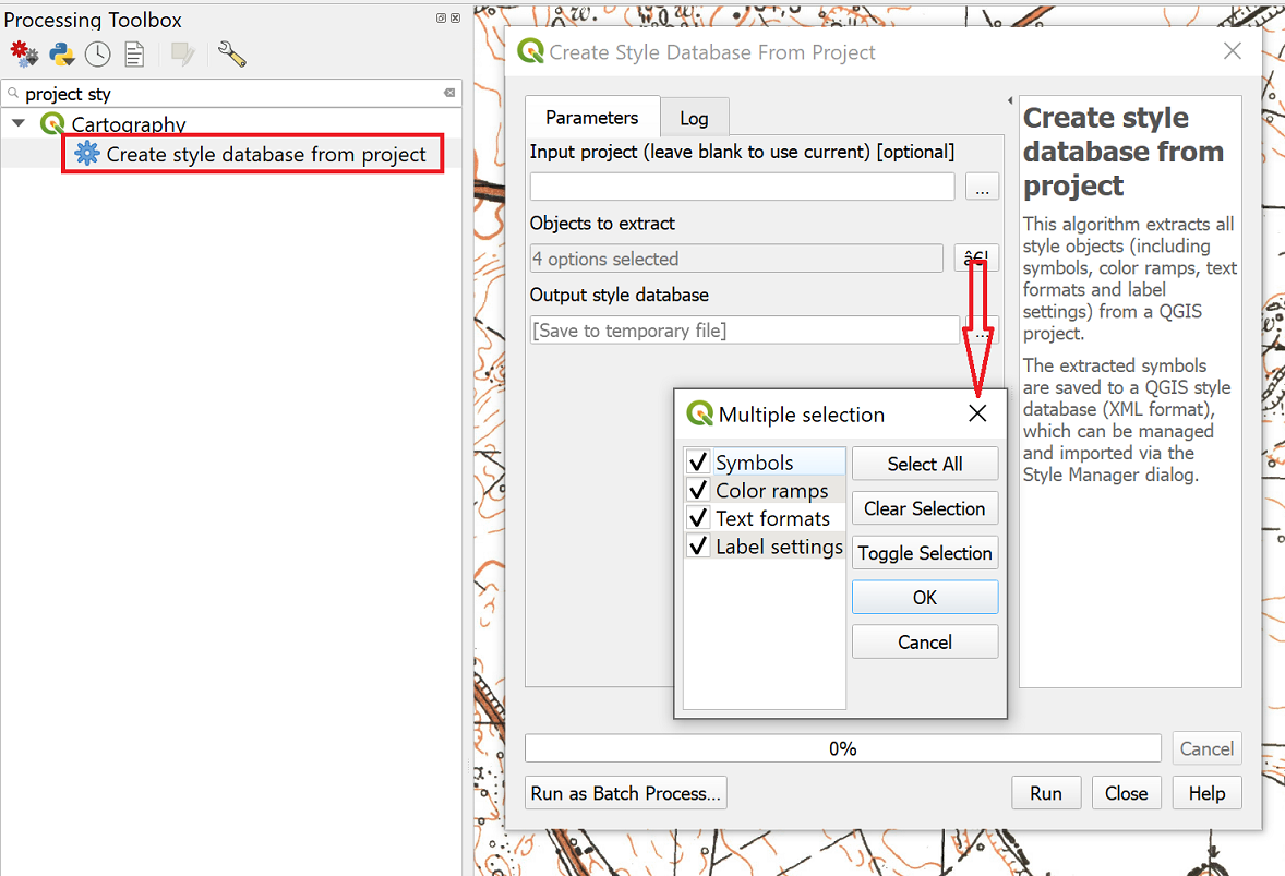
Šią savybę finansavo SMEC/SJ
Šią savybę sukūrė Nyall Dawson (North Road)
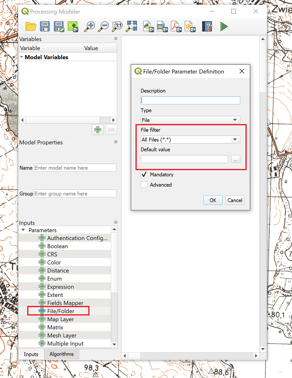
Feature: File filter and default values for file and folder inputs in models
For file or folder inputs in Processing models we’ve added a new file filter setting (with some standard file formats available as an optional preset), and now allow you to set a default value for these inputs.
Šią savybę finansavo North Road
Šią savybę sukūrė Nyall Dawson (North Road)
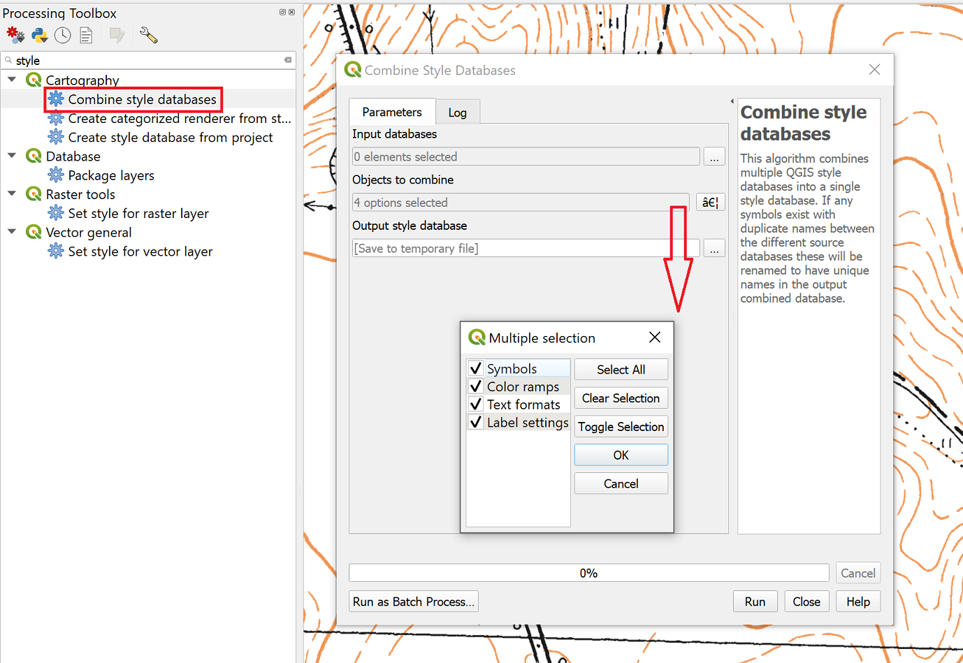
Feature: New algorithm „Combine style databases“
The new „Combine style databases“ algorithm combines multiple QGIS style databases into a single output style database. If any symbols exist with duplicate names between the different source databases these will be renamed to have unique names in the output combined database. It’s designed to give users an easy way to condense multiple separate style databases into a single unified database.
It works brilliantly with results generated by running the „Create style database from project“ in a batch mode!
Šią savybę finansavo SMEC/SJ
Šią savybę sukūrė Nyall Dawson (North Road)
Feature: Generate XYZ tiles using multiple threads
The existing Generate XYZ tiles algorithm has been optimised and can now generate tiles using multiple processing threads.
This feature was developed by Isghj5
Feature: New algorithms for exporting and importing bookmarks to/from map layers
To complement the spatial bookmark overhaul in QGIS 3.10, we’ve added new Processing algorithms which allow you to create a bunch of new bookmarks corresponding to the features from a layer, or to export existing spatial bookmark extents to a new polygon layer.
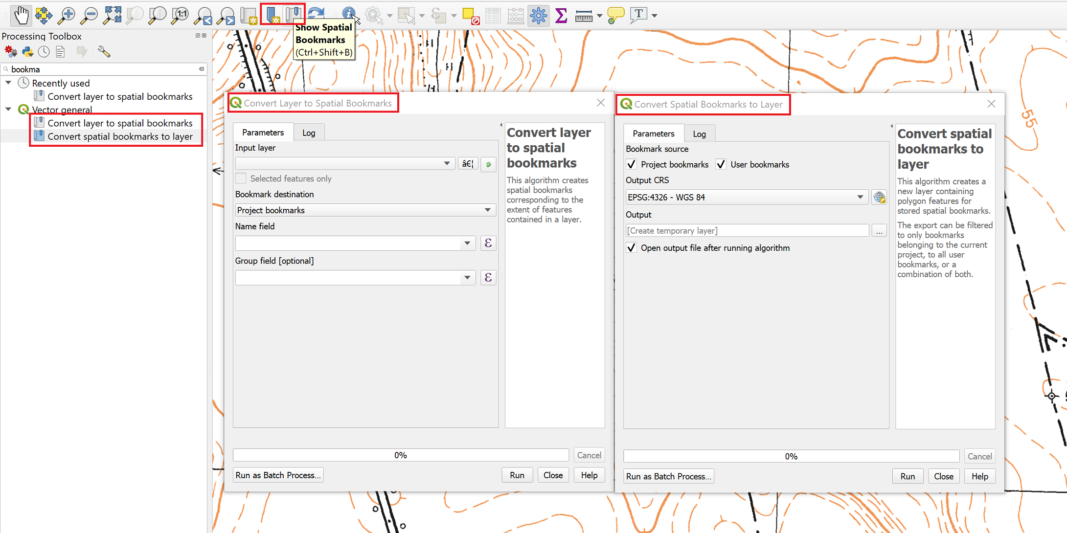
Šią savybę finansavo North Road
Šią savybę sukūrė Nyall Dawson (North Road)
Feature: New algorithm „Split features by character“
This brand new algorithm splits features into multiple output features, by splitting a field value with a specified character.
For instance, if a layer contains features with multiple comma separated values contained in a single field, this algorithm can be used to split these values up across multiple output features. Geometries and other attributes remain unchanged in the output.
Optionally, the separator string can be a regular expression for added flexibility.
This algorithm was designed for use in models which need to process input files with multiple concatenated values in a single attribute, e.g. geocoding a table with „address1,address2,address3“ format strings.
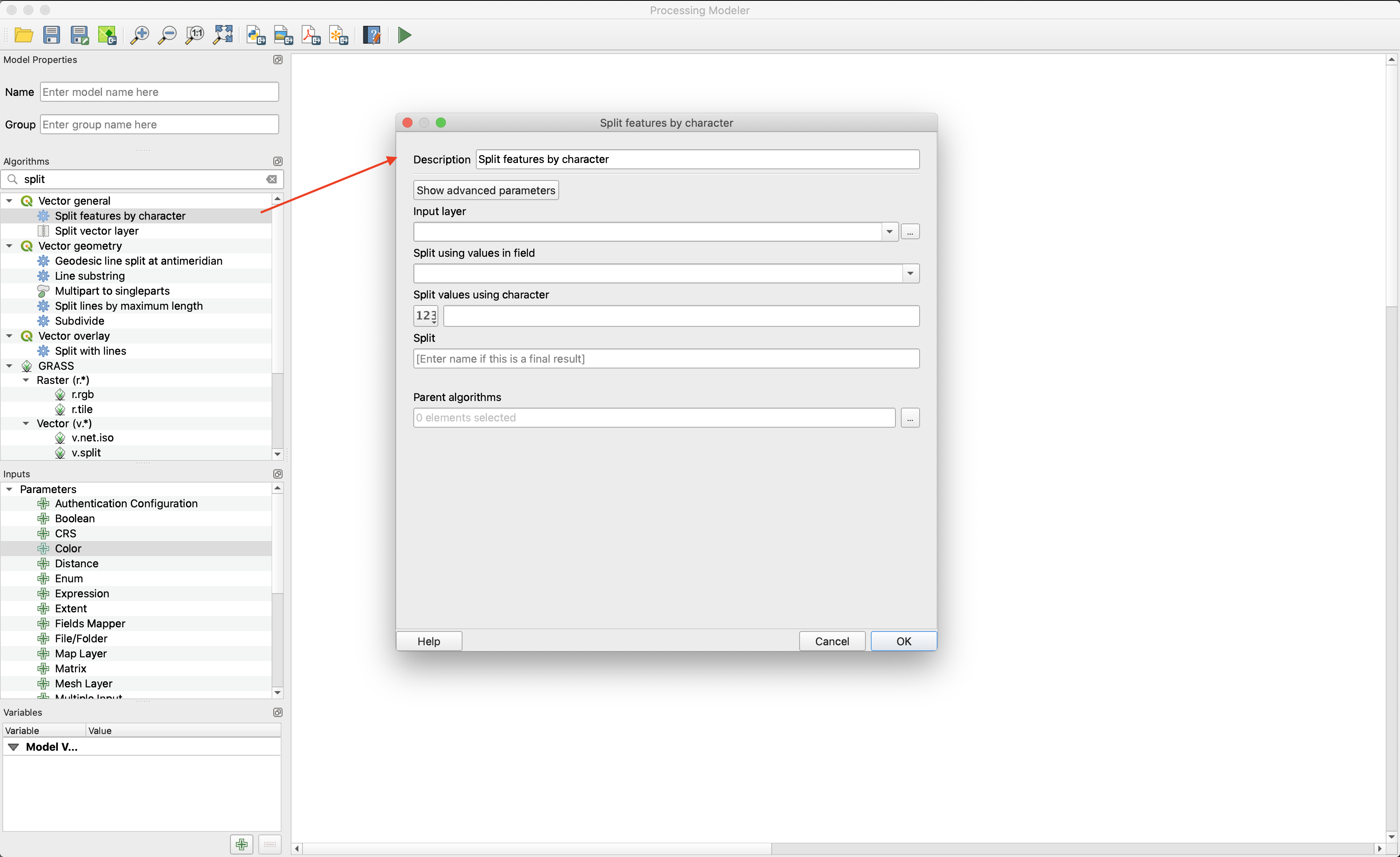
Šią savybę finansavo SMEC/SJ
Šią savybę sukūrė Nyall Dawson (North Road)
Feature: New algorithm Climb Along Line
Previously available as a plugin, the „Climb Along Line“ algorithm has been added to the out-of-the-box QGIS toolset. This algorithm calculates the accumulated height differences for lines in an input line layer, calculated using the Z values of the line vertices. A copy of the input line layer is returned with additional attributes for accumulated climb and descent, as well as the minimum and maximum Z values for each line.
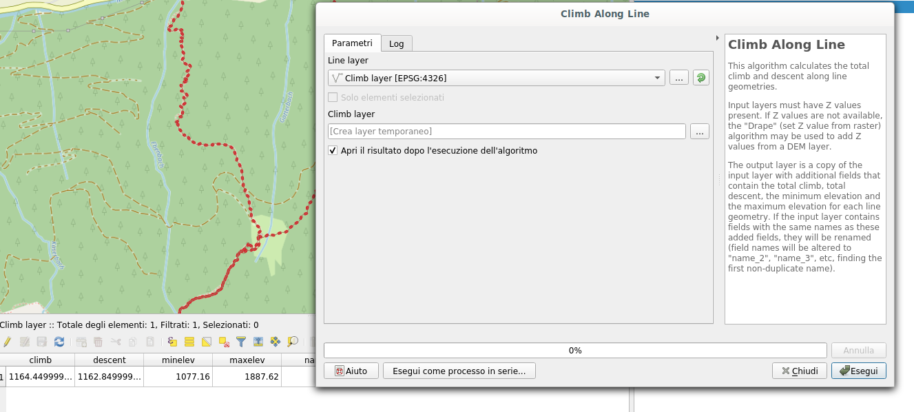
This feature was developed by Håvard Tveite (NMBU) and Matteo Ghetta (Faunalia)
Feature: Port Create Grid algorithm to C++
We ported the Create Grid algorithm from Python to C++ in order to speed up the algorithm. The algorithm now performs much faster for you and is also capable of creating point|line|rectangle|diamond|hexagon regular vector grids in high resolution in huge extents (eg. whole nations) in a reasonable amount of time.
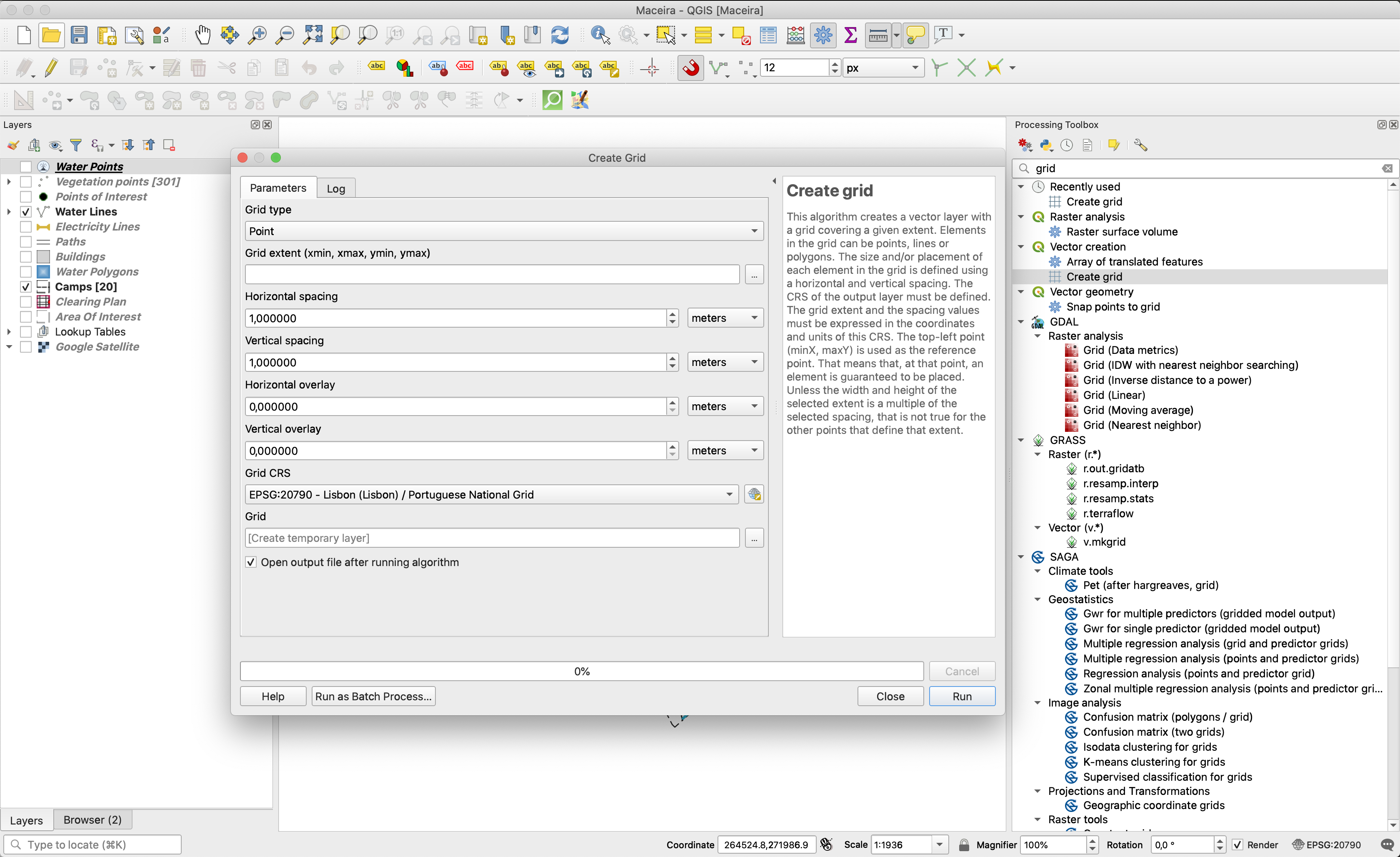
This feature was funded by Clemens Raffler
This feature was developed by Clemens Raffler
Naršyklė
Feature: Extract symbols from QGIS projects within the browser
QGIS‘ Browser panel just keeps getting more and more powerful! In 3.10, we’ve added a new option when right-clicking a QGIS project within the browser: „Extract Symbols“. Selecting this option opens a style manager dialog showing all symbols, color ramps, text formats and label settings from the selected project, allowing you to easily export the browse these symbols.
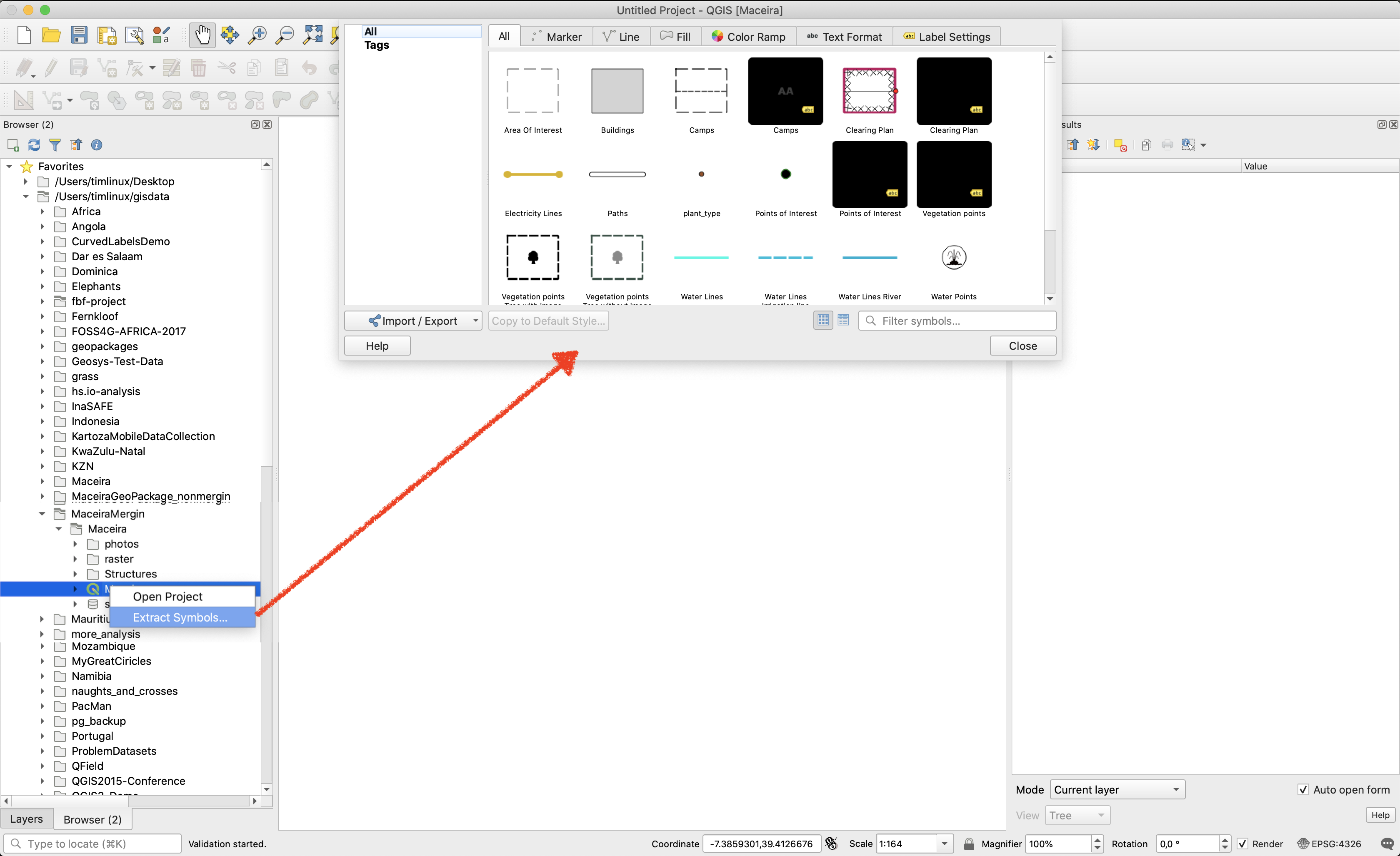
Šią savybę finansavo North Road
Šią savybę sukūrė Nyall Dawson (North Road)
Bendra
Feature: Show news items on welcome page
A curated QGIS news feed is now shown on the welcome page. This finally gives us a direct channel to push project news to ALL our users! Expect to see lots of interesting QGIS news, tips, and events coming your way!
This feature was funded by QGIS.org
Šią savybę sukūrė Nyall Dawson (North Road)
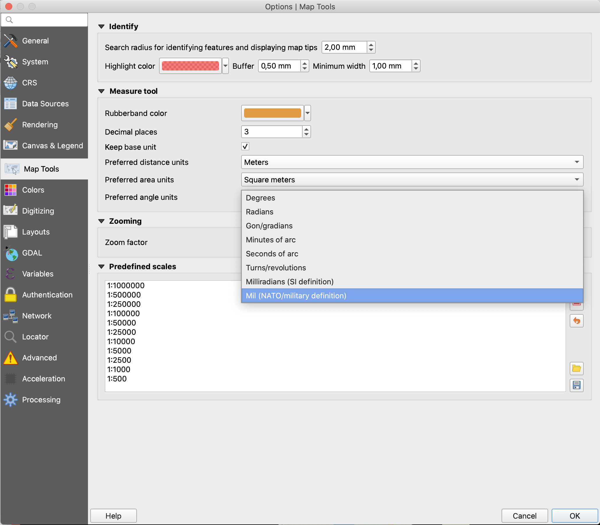
Feature: Milliradians (SI definition) and mil (NATO) units
QGIS 3.10 allows you to measure angles in two new units, milliradians (SI definition) and mil (NATO) units.
Šią savybę finansavo North Road
Šią savybę sukūrė Nyall Dawson (North Road)
Feature: Interface Customization dialog filtering
We’ve added a new „search“ box to the Interface Customization dialog, which allows you to filter through the widgets and easily find the widget you are trying to customize…
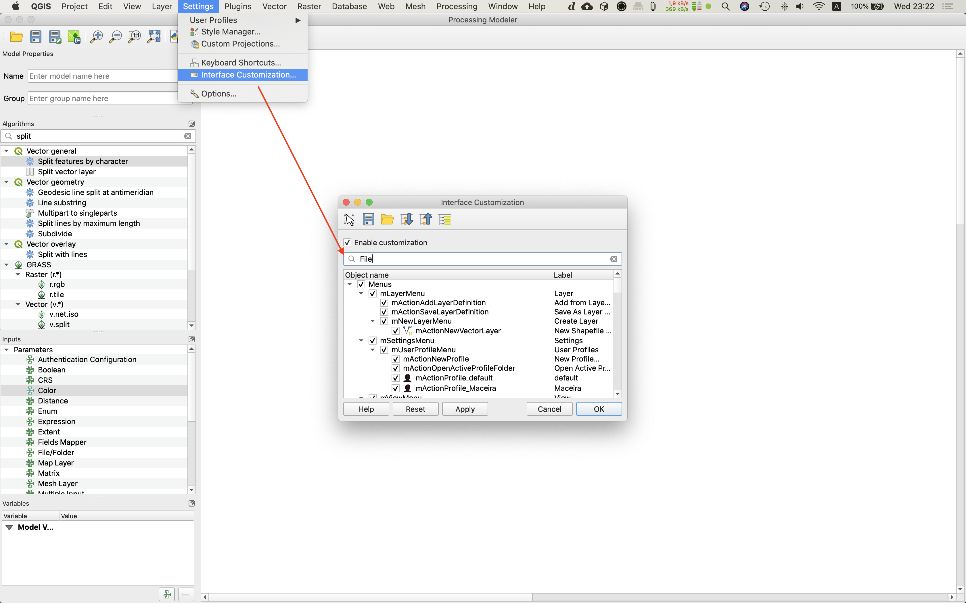
This feature was developed by DelazJ
Feature: Improved auto-fix broken layers
When a layer path is fixed in a project, QGIS 3.10 will automatically scan through all other broken paths and try to auto-fix any others which were also pointing to the same original broken file path. Any change which speeds up fixing broken layer paths is a welcome change in our view!
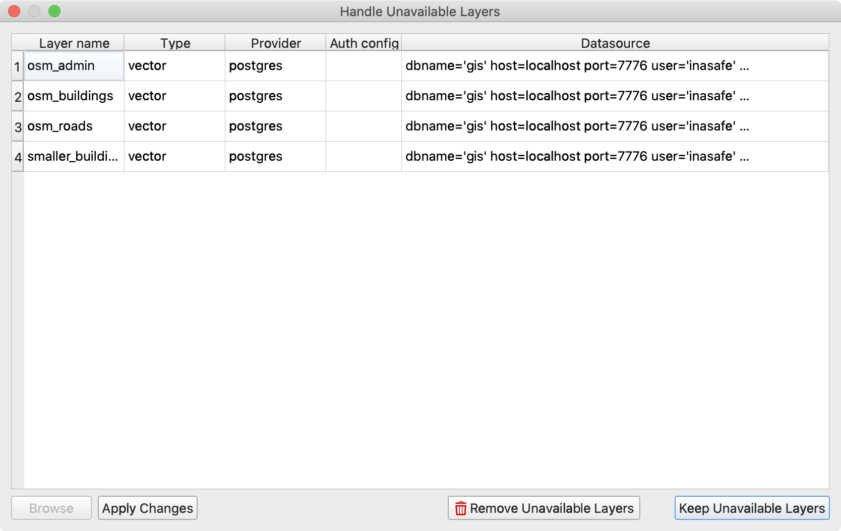
Šią savybę finansavo North Road
Šią savybę sukūrė Nyall Dawson (North Road)
Feature: Spatial bookmarks supercharged!
We’ve totally revamped how spatial bookmarks are exposed and managed in QGIS 3.10. Spatial Bookmarks are now shown in the browser panel, and can be regrouped into custom, categorized folders. This offers a much easier way to navigate and manage your bookmarks.
We also added a brand new bookmark editor dialog, which features an extent widget that greatly facilitates bookmark editing.
Bookmarks can also now be dragged and dropped onto canvases, allowing secondary canvases to zoom to a particular bookmark. This allows bookmarks to play nice in multi-canvas projects, since you can drop them onto a specific canvas to zoom.
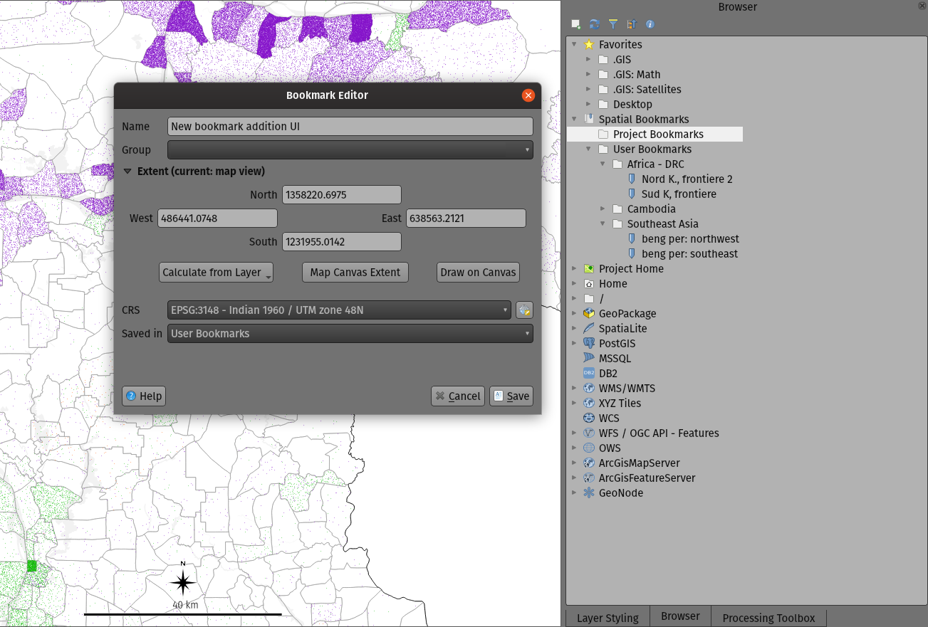
Šią savybę sukūrė Mathieu Pellerin, Nyall Dawson
Feature: „Reselect Features“ action in Edit -> Select menu
Ever spend 10 minutes painstakingly creating an interactive selection of features, only to accidentally deselect them all through an errant mouse click? If so, this feature is designed just for you! Now, you can restore a layer’s selection following a selection clear operation via the new „Reselect Features“ option in the Edit menu.
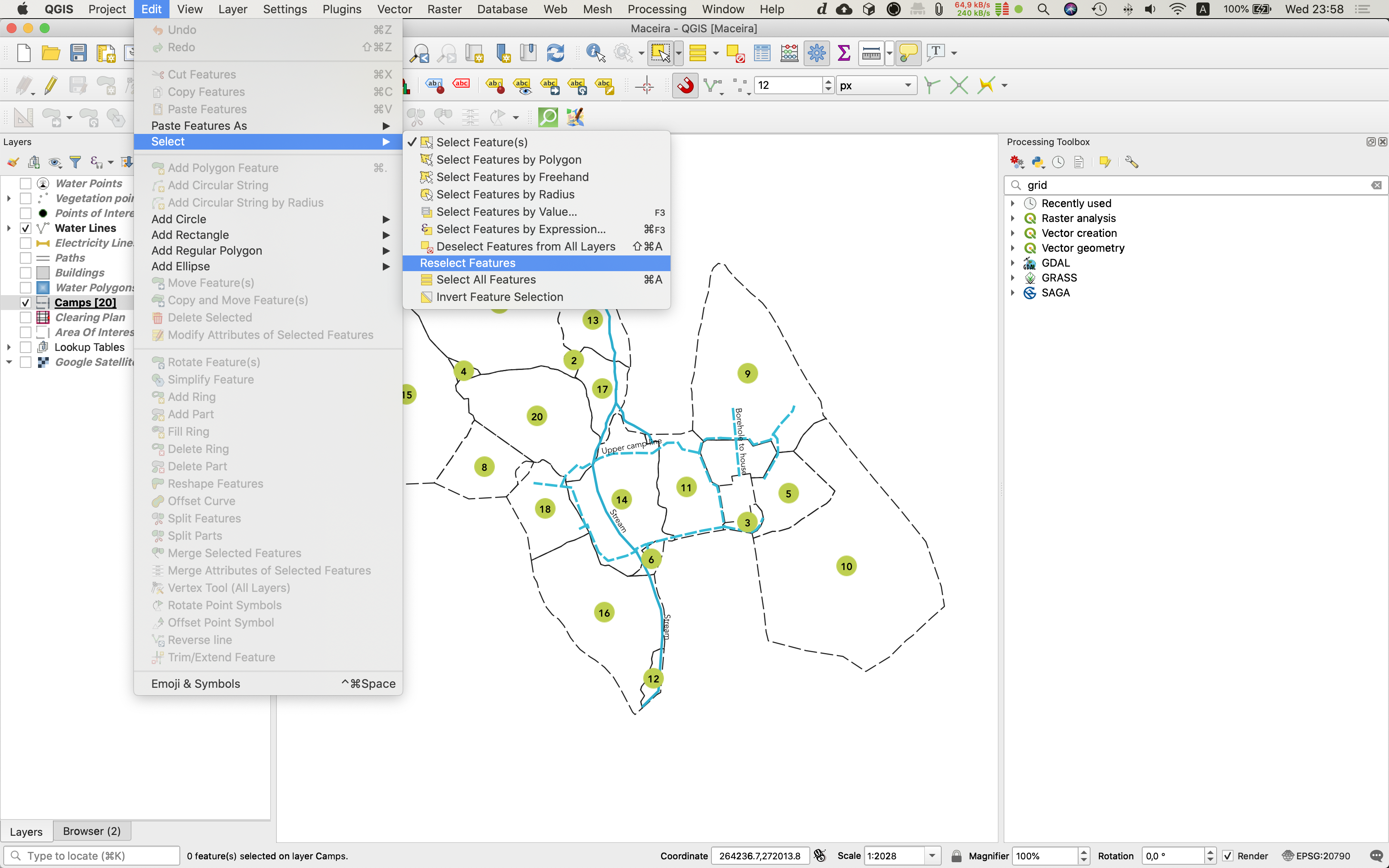
Šią savybę finansavo North Road
Šią savybę sukūrė Nyall Dawson (North Road)
Feature: Parallelize snap index build
The idea was to parallelize for each layer the snap cache computing (sequential at the moment) and to make it non blocking. As a consequence it is still possible to use QGIS even if snap cache is currently building. User can for instance start to edit node while the snap cache build is in progress.
This feature was developed by Oslandia
Feature: Templates for QGIS Projects
QGIS 3.10 includes the ability to directly use Project Templates from the welcome page. Additionally, you can now ship project templates to your whole organisation by placing them in a system folder, next to the already existing possibility to put it into a user profile folder.
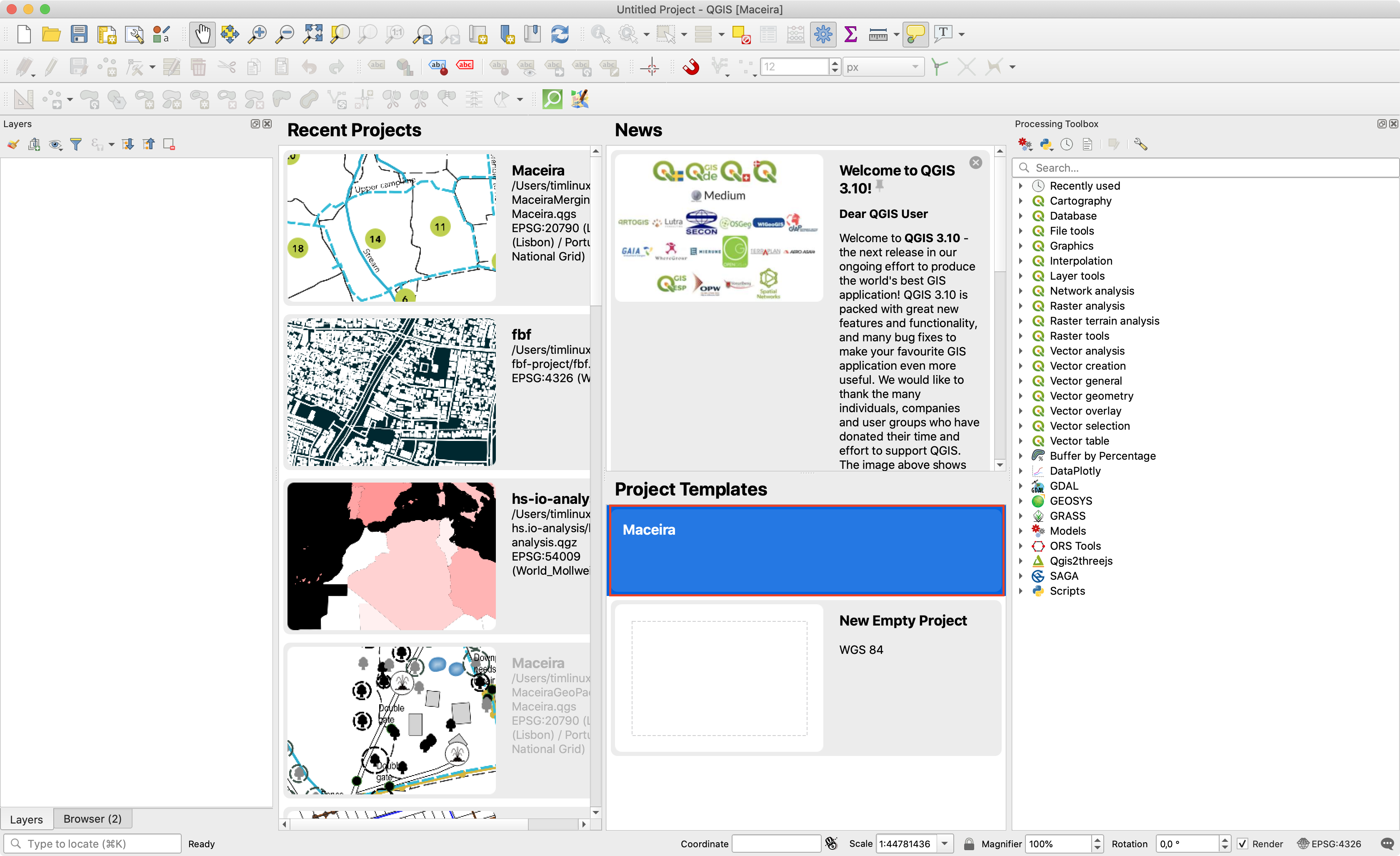
Šią savybę finansavo QGIS Projektas
Šią savybę sukūrė Matthias Kuhn (OPENGIS.ch)
Duomenų tiekėjai
Feature: Read-write support for .shz and .shp.zip
For QGIS builds based on GDAL 3.1, you can now open and edit single-layer ZIP compressed shapefiles (.shz), or multi-layer ones (.shp.zip). Regardless of where you sit on the Shapefile vs Geopackage battle, you’ll welcome this ability to de-clutter your folders and store shapefiles as a single file!
Šią savybę sukūrė Even Rouault
Feature: Oracle provider authentication
We’ve updated the Oracle database provider to add full support for QGIS built-in authentication system.
Šią savybę sukūrė Jürgen Fischer
Feature: Improved PostGIS raster support
PostGIS raster layers are now shown in the Browser panel and from the Data Source Manager dialog, allowing you to easily manage and add these layers to your projects. Currently only read support from browser is supported - you cannot drag rasters into a PostGIS database using the browser.
Šią savybę sukūrė Alessandro Pasotti
Feature: Oracle - Database transaction support
For version 3.10, we’ve enhanced the Oracle database provider and added support for editing layers via transactions.
Šią savybę sukūrė Nyall Dawson (North Road)
Feature: Z/M dimensions in delimited text layers
We’ve added optional support for Z and M fields to QGIS‘ delimited text provider, allowing you to create Z or M enabled layers directly from CSV files.
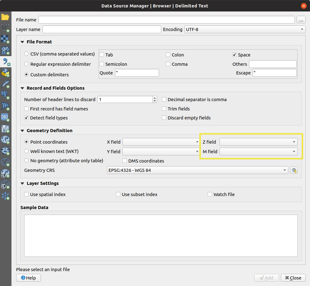
Šią savybę sukūrė Mathieu Pellerin
Feature: Static data providers
One huge behind-the-scenes job we completed for QGIS 3.10 is a refactoring of the provider infrastructure. Now, providers allow both dynamic and static linking. This was a pre-requisite to be able to build QGIS libraries on platforms that do not support dynamic linkage (iOS), and allows for QGIS based tools like the Input data collection app to be distributed for iOS based devices!
This feature was funded by Lutra Consulting Ltd.
This feature was developed by Peter Petrik, Martin Dobias
QGIS Serveris
Feature: Using SVG in QGIS Server
Earlier QGIS server versions had rendering issues when remote SVG files were used in a project (e.g. those hosted via external http servers). We’ve improved how QGIS Server fetches these resources, and it’s now possible to use remote SVG paths in your layers and publish them as WMS without rendering issues in QGIS Server.
This feature was funded by Ifremer
This feature was developed by René-Luc D’Hont (3Liz)
Feature: WMS dimension
In QGIS 3.10 a WMS server can provide support for several type of dimensions such as time, elevation or other types of dimensions. The dimension has to be defined as the layer level and can be used by the WMS client to filter requested information. WMS Time is part of the WMS Dimension.
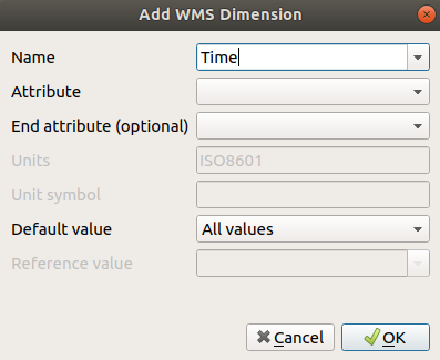
This feature was funded by Ifremer
This feature was developed by René-Luc D’Hont (3Liz)
Feature: Server OAPIF (aka WFS3) support
QGIS 3.10 Server is one of the very first geospatial servers which supports the new OGC API - Features - Part 1: Core standard (also known as WFS3)!
This is a completely new implementation that provides an HTML and JSON based service for your web mapping developments, including a simple WebGIS interface which is available out of the box and it is easily customizable through an HTML template system.
More information is available in the documentation
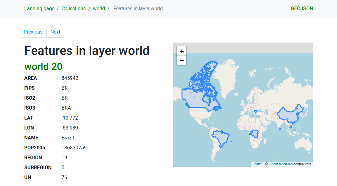
This feature was developed by Alessandro Pasotti
Programavimas
Feature: New class QgsBookmarkManager
Attached to QgsProject and QgsApplication, this new class provides a stable, supported method of managing project and global bookmarks (vs the old undocumented, not stable approach of directly manipulating project keys or a sqlite database). Now your plugins and scripts are capable of reading, modifying, and managing spatial bookmarks!
Šią savybę finansavo North Road
Šią savybę sukūrė Nyall Dawson (North Road)
Feature: New API for provider database connections
Thanks to funding from the QGIS grant program, you can now use a new API aimed to manage DB connections in a unified way. The new connection API also provides a set of useful methods that can be used by plugin authors to access information about tables, schemas etc. and to run SQL arbitrary queries and get the results back into a handy Python array.
This feature was funded by QGIS
This feature was developed by Alessandro Pasotti
Svarbūs pataisymai
Savybė: Alessandro Pasotti riktų pataisymai
Rikto pavadinimas |
URL issues (if reported) |
URL PR or commit |
3.4 backport PR or commit |
|---|---|---|---|
Crash when deleting print layout items |
|||
DB manager python error |
|||
QGIS 3.4.11: Clicking a PDF URL in GetFeatureInfo response generates error |
Already fixed (by me) on 3.8 and Master |
||
Watch file not adding new columns |
|||
Loss of labels background from older project/style |
|||
„Text formats“ dialog shows modifiable buffer properties while the „draw text buffer“ is unchecked |
|||
Symbology tab widget does not horizontally expand in the layer properties dialog extent |
|||
Watch file not adding new columns |
|||
Unreported but related to #31452 |
|||
Unable to add WMS service in QGIS, same URL works in other clients |
|||
QGIS Server - Download of capabilities failed: SSL handshake failed |
|||
apparent regression in raster calculator multiplying conditionals |
|||
Broken GPKG browser actions |
|||
Resizing the data source manager dialog fails to resize unfocused panels |
|||
In place processing multipart to singleparts does not handle unique constraints |
|||
crash when adding legend via python |
|||
UI: Legend does not refresh after classifincation bounds updated |
Not affected |
||
UI: PostGIS layer error message not helpful, disappears and shouldn’t happen |
|||
Server GetLegendGraphics contextual (BBOX) fails if no WIDTH and HEIGHT are supplied |
|||
extend/trim crash |
|||
UI: any click on number of classes updown triggers twice |
|||
GPKG project is not marked dirty after it is deleted from the storage |
|||
Fix unreported issue with QVariantList to JSON conversion in QgsJsonUtils |
nepranešta |
||
Crash on adding WMS |
|||
Raster calculator change sign does not work when OpenCL is on |
|||
Snapping map units always show „meters even when the project is in different units |
|||
QGIS Raster Calculator outputs nodata only rasters |
|||
Opening projects from PostgreSQL issue |
|||
GetLegendGraphic shows all identical symbols for content based legend |
|||
WFS doesn’t recognize advertised GeoJSON outputFormat string |
|||
creating indexes on geopackage failes (QGIS 3.8.3) |
|||
DB manager import option „Create single-part geometries instead of multi-part“ is broken |
|||
GetLegendGraphic shows all identical symbols for content based legend |
|||
WFS contextual legend issue when canvas CRS is different than layer’s CRS |
nepranešta |
||
PostGIS/geojson: Cannot input negative numbers in int fields |
|||
Information tab in WMS layer properties is unresponsive if a WMS service contains many layers |
|||
Data Source UI - PostgreSQL table multi-line comments make the grid table hard to read |
|||
More null pointer dereferences when plugins are off |
|||
null pointer dereferences when plugins are off |
|||
„Merge features“ and „merge feature attributes“ have broken numerical functions |
This feature was funded by QGIS.ORG (through donations and sustaining memberships)
Šią savybę sukūrė Alessandro Pasotti
Savybė: Alexander Bruy riktų pataisymai
Rikto pavadinimas |
URL issues (if reported) |
URL PR or commit |
3.4 backport PR or commit |
|---|---|---|---|
GDAL scripts in Processing need quoting on attribute names |
|||
Processing GDAL algorithms does not handle correctly WFS input layers |
|||
shp files in zip files files cannot be used in Processing with 3rd party providers (SAGA, GRASS…) |
|||
Not possible to toggle use selected features in the Processing layer combobox |
|||
Connect to postgis database fails in „Layer - Add Postgis layer“ on databases with weird table names |
|||
GRASS v.build.polylines dosn’t work in Qgis 3.4.10 |
|||
Processing Algorithms written with the @alg decorator don’t get the gear icon |
|||
v.drape - no 25D export with SpatiaLite format |
|||
Service url cannot include custom query parameters |
|||
Processing: python error on startup |
|||
Saving Processing’s Package Layers algorithm’s output to default temporary output leaves no result |
|||
[Georeferencer] GDAL script does not set target SR |
|||
Processing „Build virtual vector“ now fails in certain cases |
|||
Unreported issue with missed import in the Processing algorithms dialog |
nepranešta |
||
db manager: python error when clicking „edit table“ if the table is a postgis raster |
|||
DB Manager: Renaming a PostGIS geometry column causes it to lose its geometry type and SRS |
|||
Georeferencer incorrectly shows last image when reopened |
|||
DB Manager: Create Layer dialog should be closed or cleared once the new layer is generated |
|||
[Vector Save As…] Extension is not replaced in filename when switching format |
This feature was funded by QGIS.ORG (through donations and sustaining memberships)
Šią savybę sukūrė Alexander Bruy
Savybė: Peter Petrik ištaisyti riktai
Rikto pavadinimas |
URL issues (if reported) |
URL PR or commit |
3.4 backport PR or commit |
|---|---|---|---|
Reproducible Crash: retrieving QgsHighlight instance stored as a widget property |
|||
Layer styling Mesh layer does not respond to change of Color ramp (first time) |
|||
qgis crashed on close in QSortFilterProxyModel |
|||
QGIS freezes |
|||
Crash when trying to save a project |
|||
Crash on exit with advanced digitizing active |
|||
Renaming macOS app causes authentication error |
|||
QGIS cannot be opened after updating to Mac OS Catalina |
This feature was funded by QGIS.ORG (through donations and sustaining memberships)
Šią savybę sukūrė Peter Petrik
Savybė: Even Rouault riktų pataisymai
Rikto pavadinimas |
URL issues (if reported) |
URL PR or commit |
3.4 backport PR or commit |
|---|---|---|---|
QGIS master crash upon exit @ QgsCoordinateTransformPrivate::freeProj on Windows platform |
|||
QGIS master crash upon exit @ QgsCoordinateTransformPrivate::freeProj on Windows platform |
|||
QGIS WFS stripping of viewparam KVP from WFS Feature Requests |
|||
Crash: right click on image ->export ->save as->“save raster layer as“ |
|||
crash in discover relations for postgresql layers |
|||
Exporting raster as raw data to GeoPackage fails silently |
|||
QGIS crashes after deactivating a GDAL driver in use in the project |
|||
Crash exporting to GS7BG format |
|||
pgdump is no longer a recognized format for the GDAL/OGR convert format algorithm |
not worth |
||
PBF files not loading correctly |
|||
Error importing cover from Geoserver WFS service |
|||
Feature count from online Geojson not updated upon refresh |
not worth |
||
Edits in GeoJson datasources are not saved anymore |
Backported to GDAL 3.0 and 2.4 maintenance branches |
This feature was funded by QGIS.ORG (through donations and sustaining memberships)
Šią savybę sukūrė Even Rouault
Feature: Bug fixes by Sandro Santilli
Rikto pavadinimas |
URL issues (if reported) |
URL PR or commit |
3.4 backport PR or commit |
|---|---|---|---|
Adding Postgis rasters from DB Manager ask for password for each add |
|||
[processing] segmentizebymaxdistance puts qgis in endless CPU loop |
|||
file INSTALL cannot find doc/api/html |
nėra |
||
QGIS died on signal 11 # at start up |
|||
repository files modified by |
|||
CMake Error at cmake/FindGEOS.cmake:162 |
|||
False success from ogr provider’s committChanges |
|||
TestSagaAlgorithms: line 139, in check_algorithm: ‚NoneType‘ object has no attribute ‚checkParameterValues‘ |
nėra |
||
PostGIS Data Loads Extemely Slow |
This feature was funded by QGIS.ORG (through donations and sustaining memberships)
This feature was developed by Sandro Santilli
Feature: Bug fixes by Matthias Kuhn
Rikto pavadinimas |
URL issues (if reported) |
URL PR or commit |
3.4 backport PR or commit |
|---|---|---|---|
Crash when opening symbology tab of invalid layer |
nėra |
||
PR reviews |
Many :D |
||
qgz are marked as temporary on windows |
|||
Allow selecting geometry type in context |
nėra |
This feature was funded by QGIS.ORG (through donations and sustaining memberships)
This feature was developed by Matthias Kuhn
Feature: Bug fixes by Paul Blottiere
Rikto pavadinimas |
URL issues (if reported) |
URL PR or commit |
3.4 backport PR or commit |
|---|---|---|---|
Fixes invalid schemaLocation in GetCapabilities doc |
|||
Invalid WMS GetFeatureInfo response with json info_format |
PR #32386/files |
||
QGIS Server SELECTION doesn’t work with Postgres ids of type bigint or text |
|||
Regression with opacities for the WMS GetPrint request |
|||
Unreported regression: Invalid renderer type after loading a QML style file |
unreported regression |
This feature was funded by QGIS.ORG (through donations and sustaining memberships)
Šią savybę sukūrė Paul Blottiere
Savybė: Nyall Dawson ištaisyti riktai
Rikto pavadinimas |
URL issues (if reported) |
URL PR or commit |
3.4 backport PR or commit |
|---|---|---|---|
Fix crash when deleting layouts from designer window |
nėra |
||
Fix model to python when model has no input parameters |
nėra |
||
Fix string escaping when converting models to python code |
nėra |
||
Fix memory leak |
nėra |
||
Fix potential overflow in raster renderer |
nėra |
||
Restore project variables early in the project read cycle |
nėra |
||
Improve docs for Join by Nearest, raise warning in log |
nėra |
||
Catch some reprojection exceptions during raster rendering |
nėra |
||
[labeling] Fix broken numeric formatting settings, add tests |
nėra |
||
Fix uncaught transform exception when determining AFS layer bounds |
nepranešta |
nėra |
|
Fix qt warning thrown when converting a 2.18 project |
nepranešta |
nėra |
|
Add option to take no action („Leave as an unknown CRS“) when a layer is loaded which has no CRS |
#19762, #27634, #24815 (and probably others) |
nėra |
|
Don’t force fallback to WGS84 for unknown layer CRSes |
nepranešta |
nėra |
|
Fix memory layers cannot use non-EPSG CRS codes |
unreported, but likely a cause of many bugs |
nėra |
|
Fix crash after deleting report sections |
|||
Ensure polygon rings generated for rendering are always closed |
nepranešta |
nėra |
|
Don’t crash QgsTessellator when an empty polygon is added |
nepranešta |
nėra |
|
Fix crash in topology checker plugin after a check is canceled |
nepranešta |
nėra |
|
Fix topology checker multipart check |
nėra |
||
Fix crash on exit when topology checker dock is open with visible results |
nepranešta |
nėra |
|
Don’t load print layouts when opening project browser items |
via email |
nėra |
|
Add QgsProject flag to avoid loading print layouts when reading a project file, avoids crashes when project is loaded in background thread |
via email |
nėra |
|
Don’t try to load HTML content when a layout is created in a background thread |
via email |
||
Huge speed up to QgsTessellator |
nėra |
||
[processing] Ensure all objects used by the model are correctly imported |
nėra |
||
[processing] Avoid confusing use of expression parameter type in Random Points in Polygon algorithm |
nėra |
||
[layouts] Update map settings variables in UI when map extent/rotation changes |
nėra |
||
[layouts] Fix layout variables set programmatically do not show in GUI |
nėra |
||
[layouts] Ensure variable panels are updated when layout or atlas properties change |
nėra |
||
[layouts] Move page background setting to a per-page option |
nėra |
||
Optimize QgsContrastEnhancementFunction |
nėra |
||
[layouts] Prevent removal of the last remaining page in a layout |
via email |
||
[layouts] Fix crash when exporting layout with no pages |
via email |
||
Fix conditional formatting panel high dpi issues |
nėra |
||
Fix loss of font setting when editing conditional format |
nėra |
||
Avoid overflow in QgsImageOperation |
|||
[processing] Extend api for retrieving a layer in a compatible format |
via 3rd party plugin bug tracker |
nėra |
|
Fix conditional styles in feature list view do not update when the layer’s conditional styles are changed |
nėra |
||
Fix broken display of conditional styles in feature list view |
nėra |
||
Fix incorrect conditional styling applied to rows in some cases |
nėra |
||
Use invalid colors, not transparent colors, to indict not set colors in conditional formats, fixes incorrect colors used for conditionally styled rows |
nėra |
||
„[labeling] When an extreme number of features are being labeled from a single layer, place additional limits on the maximum number of |
|||
labeling candidates to generate for features in this layer“ |
nėra |
||
[layouts] Fix incorrect alignment of items when the align or distribute tools are used with items with a non-top-left reference point |
nėra |
||
[processing] Respect user set default vector output format in vector split algorithm |
nėra |
||
Fix GUI is not updated when layout atlas is set to use the default filename expression |
nėra |
||
[reports] Remove useless extra set of export actions |
nėra |
||
[reports] Fix crash when print button clicked before a report section is opened |
nepranešta |
nėra |
|
[reports] Reduce minimum width of report organiser dock |
nėra |
||
[layouts] Add a page number selection combo box at the top of the guide manager dock |
nėra |
||
Show color button style „Pick color“ and „Chooe Color“ and symbol button menu |
nėra |
||
Fix out of sync layout bounds after page removal |
nėra |
||
[layouts] Fix odd selection behavior when keyboard modifiers are pressed when rectangular selection ends |
nėra |
||
Fix interaction with group members in items panel |
nėra |
||
[layout] Fix invalid svg exports when including metadata |
nėra |
||
[legends] Fix missing symbols for inverted polygon layers when using filter by map content |
nėra |
||
Use a slightly larger font size in CRS details on Windows |
nėra |
||
[processing] Add warning when packaging a geopackage with no layers |
nėra |
||
[layouts] Fix crash when opening layout with dynamic image in html label |
|||
Expose report feature settings when an attribute table is used in an atlas |
nėra |
||
[layouts] Fix attribute table ignores cell margin for top/bottom aligned text |
nėra |
||
Fix truncated legend symbol borders when layer has opacity set |
nėra |
||
Fix adding/moving legend is very slow with large projects |
nėra |
||
[reports] Fix predefined scale mode is incompatible with report outputs |
nėra |
||
Ensure atlas expression evaluation has access to coverage layer scope |
nėra |
||
Resizing pages to content should not create empty page size if no items are present |
nėra |
||
Fix map rotation does not immediately restore in reports |
nėra |
||
Do not return nan values when an assistant is used with min val == max val |
nėra |
||
[layouts] Fix label items don’t update when their opacity < 100 |
nėra |
||
Fix project load status indicator can get „stuck“ after project load |
nepranešta |
nėra |
|
Fix corrupted expressions in filter indicator tooltips |
|||
Fix cannot use GPS panel to draw features in multi polygon/line |
nėra |
||
Fix loss of label background settings when restoring projects. |
nėra |
||
Fix crash in point displacement renderer |
nėra |
This feature was funded by QGIS.ORG (through donations and sustaining memberships)
Šią savybę sukūrė Nyall Dawson