QGIS 3.34 muutosloki

Julkaisupäivä: 2023-10-29
Nyt esittelyssä on QGIS-projektin julkaisu QGIS 3.34, joka tuo merkittäviä parannuksia QGISiin, avoimen lähdekoodin paikkatiedon analysointi ja visualisointi ohjelmistoon.
Tämä julkaisu sisältää useita parannuksia olemassa oleviin API:eihin, lausekkeisiin ja työkaluihin, tulostustaiton muokkaamiseen, sekä uusia renderöintiasetuksia sekä 2D että 3D kartoille.
Kattavan yleiskatsauksen uusista toiminnallisuuksista saa katsomalla Youtubesta esittelyvideon: https://www.youtube.com/watch?v=LHFVo0edaXE
QGIS on yhteisön ja yhteistyön tulos, ja haluamme kiittää kaikkia kehittäjiä, dokumentaation kirjoittajia, testaajia ja kaikkia muita ihmisiä, jotka antavat aikaansa ja vaivaansa (tai rahoitatte muiden tekemistä), että teitte tämän julkaisun mahdolliseksi. QGIS yhteisön puolesta toivomme, että nautitte tästä julkaisusta! Jos olet kiinnostunut lahjoittamaan aikaa tai rahaa, tai muuten antamaan panoksesi QGIS kehittämiseksi entistä upeammaksi, kurkkaa tänne QGIS.ORG ja ojenna auttava kätesi.
QGIS saa tukea kannatusjäseniltä ja lahjoittajilta. Ajantasainen lista lahjoittajista, jotka ovat lahjoittaneet suuria tai pieniä summia projektille on nähtävillä Lahjoittajat -listalta. Jos haluat ryhtyä viralliseksi kannatusjäseneksi, tutustu kannatusjäsenet ja lahjoitukset -sivuun . QGISin sponsorointi auttaa meitä rahoittamaan säännölliset kehittäjätapaamisemme, ylläpitämään projektin infrastruktuuria ja tukemaan vikojen korjauksia. Kattava lista nykyisistä sponsoreista on annettu alla - suurimmat kiitoksemme kaikille sponsoreillemme!
QGIS on ilmainen ohjelmistä, eikä kenenkään ole tarve maksaa siitä. Itseasiassa haluamme kannustaa ihmisiä läheltä ja kaukaa kokeilemaan sitätaloudellisesta tai sosiaalisesta tilanteesta riippumatta. Uskomme että kun ihmisillä on pääsy spatiaalisen päätöksenteon työkaluihin, lopputuloksena on parempi yhteiskunta koko ihmiskunnalle.
Cesium 3D Tiles
Cesium<https://www.cesium.com/>-projektin ekosysteemilahjoituksen ansiosta QGIS tukee nyt 3D-sisällön lataamista Cesium 3D Tiles -muodossa! Tiilet voidaan ladata joko paikallisista datalähteistä tai etädatalähteistä (mukaan lukien Cesium ion -alusta ja Google Earthin fotorealistiset tiilet), ja ne näkyvät sekä 2D- että 3D-karttanäkymissä. 2D-näkymissä käyttäjä voi hallita tiilen sisällön ulkonäköä säätämällä tyyliä joko alkuperäisessä tekstuurissa tai tiilen geometrioiden rautalankanäkymässä. Lisäksi käyttäjä voi hallita sekä 3D- että 2D-näkymien yksityiskohtaisuutta.
Martin Dobias and Nyall Dawson kehittivät tämän toiminnon.
Karttatyökalut
Toiminto: Valinnainen pisteen pakottaminen desimaalierottimeksi mittaustyökalussa.
Mittaa -työkaluun on lisätty uusi Käytä aina desimaalipistettä valintaruutu. Tämä valinta takaa, että mittaustulokset ja koordinaatit, jotka kopioidaan leikepöydälle, käyttävät desimaalierottimena pistettä, vaikka käytössä olevat aluekohtaiset asetukset määrittelisivät erottimeksi pilkun.
Tämä mahdollistaa csv (comma separated values)-muotoisen datan kopioimisen myös silloin kuin käyttäjän alueelliset asetukset käyttävät pilkkua desimaalierottimena.
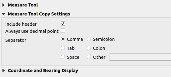
Tämän toiminnon kehitti Yoann Quenach de Quivillic
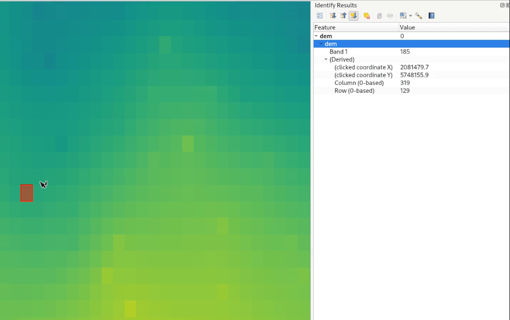
Toiminto: Korosta rasteripikselit käytettäessä näytä kohteen tiedot työkalua
Näytä kohteen tiedot -työkalua käytettäessä QGIS korostaa nyt niiden rasteritasojen kyseltävät pikselit, joiden tietoja katsellaan. Tämä on yhtenevä sen kanssa, miten näytä kohteen -tiedot työkalu käyttäytyy vektori-, vektoritiili, ja pistepilvikohdetyyppien kanssa.
Tämä on hyödyllistä, kun tietoja katsellaan rasterilta, jossa on samankaltaisin värein väritettyjä pikseleitä ja visuaalisesti on vaikea nähdä pikselin tarkka laajuus.
Tämän toiminnon kehitti Nyall Dawson
Toiminto: Näytä klikatun pisteen rasterin rivi/sarake näytä kohteen tiedot -työkalun tuloksissa
Kun käytetään Näytä kohteen tiedot -työkalua rasteritasoilla, näytettävissä tuloksissa on nyt mukana valitun pikselin rivin ja sarakkeen numero.
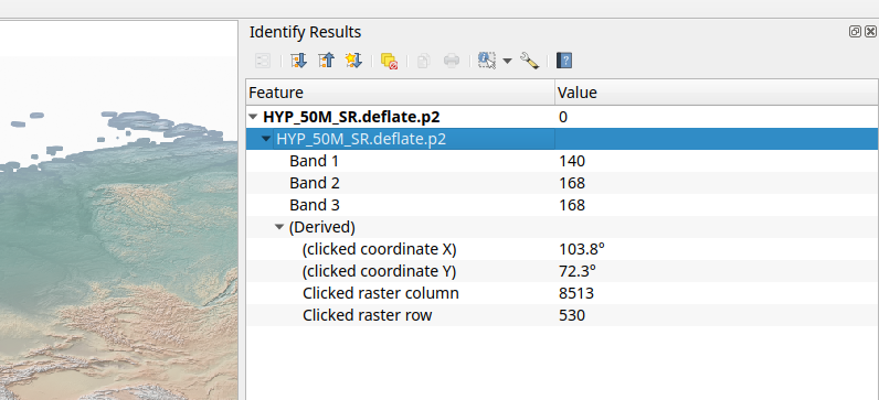
Tämän toiminnon kehittivät Hannes & Nyall Dawson
Kuvaustekniikka
Toiminto: Valinnan värin ja symbolin ohittaminen asetuksilla
Karttanäyttö astuksissa on uusi asetus, jonka avulla käyttäjä voi valita millä värillä ja symbolilla valitut kohteet korostetaan näytössä ja ohittaa näin järjestelmän tai projektin oletusasetukset.
Tämä asetus määritellään jokaiselle tasolle erikseen. Sen avulla on mahdollista parantaa valittujen kohteiden näkyvyyttä niille erityisesti valitun esitystavan avulla.
Tämä on hyödyllistä monessa tilanteessa, esimerkiksi seuraavissa tapauksissa:
Tasolla on symboli tai tyyli, joka on yhtenevä valinnan kuvaustekniikan kanssa, mikä johtaa siihen, että valitut kohteet eivät näy.
Viivatasolla on ohut symboli, ja valittujen viivojen väritys ei tuo niitä tarpeeksi näkyviksi.
Tasoihin, joilla on monimutkainen esitystekniikka (esimerkiksi rasteri- , liukuväri-, tai viivatäyttö tai väripurske), ei käytettäisi valinnan oletusväriä. Näissä tapauksissa käyttäjä voi nyt määrittää yksinkertaisemman esitystekniikan käytettäväksi tason valituille kohteille.
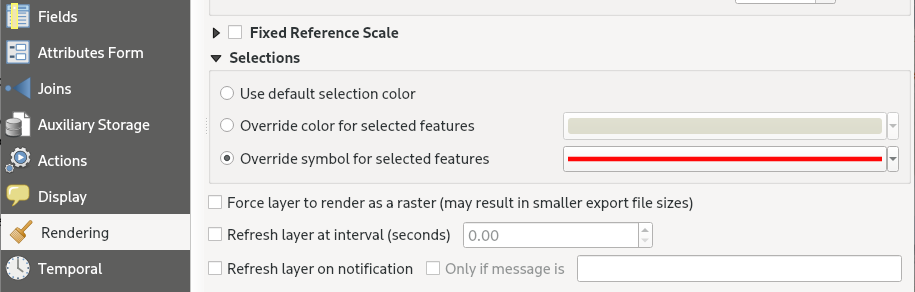
Tämän toiminnon kehitti Nyall Dawson
Nimiöinti
Feature: Toggle labels for Vector Tile Layers
Users can now toggle labels for vector tile layers using the vector tile layer styling panel and the layer context menu in the table of contents of the layers pane, effectively replicating the label toggle capabilities for vector layers.
This functionality is enabled by the addition of new functions to the QgsVectorTileLayer API by replicating the existing functionality on QgsVectorLayer.
This feature was developed by Mathieu Pellerin
Karttanäyttö
Feature: ”Sticky” Map Decorations
Dynamic map decorations are now rendered to a transparent overlay, preventing re-rendering of decoration objects (such as title or scale bar) during navigation. The QgsMapDecoration now also includes hasFixedMapPosition to fix a decoration to a geographic location.
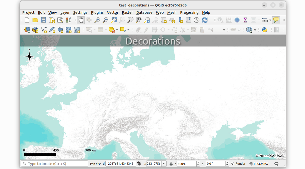
Tämän toiminnon kehitti Yoann Quenach de Quivillic
Feature: Add map render profiler
The debugging/ development profiling tools have been extended with a new ”map render” profile (accompanying the existing Startup and Project Load profiles).
Through this tool, users are able to identify pain points in their map rendering and track down exactly which layers are causing long map redraws.
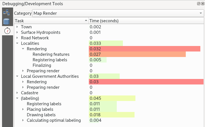
Tämän toiminnon kehitti Nyall Dawson
Feature: Add choice of two different modes for ”Refresh Layer at Interval”
When using ”Refresh Layer at Interval” on vector layers, previous versions of QGIS would simply redraw the layer (for animations etc.), without refreshing data from the data source.
A new widget is provided which allows users to select the layer refresh options according to their preferred use case:
”Reload Data”: The layer will be completely refreshed. Any cached data will be discarded and re-fetched from the provider. This mode may result in slower map refreshes.
”Redraw Layer Only”: This mode is useful for animations or when the layer style should be updated at regular intervals. Canvas updates are deferred in order to avoid refreshing multiple times if more than one layer has an automatic update interval set.
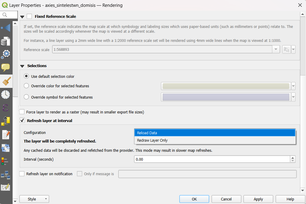
Tämän toiminnon kehitti Nyall Dawson
3D kohteet
Feature: Allow GPU memory limit configuration
Users are now able to configure the GPU memory limit configuration on each layer (previously fixed at 500MB per entity/ layer)
A warning is also displayed when a limit is hit, which should assist in troubleshooting large scenes.
This functionality is useful for users utilizing large 3D scenes which exhaust the available GPU memory resources.
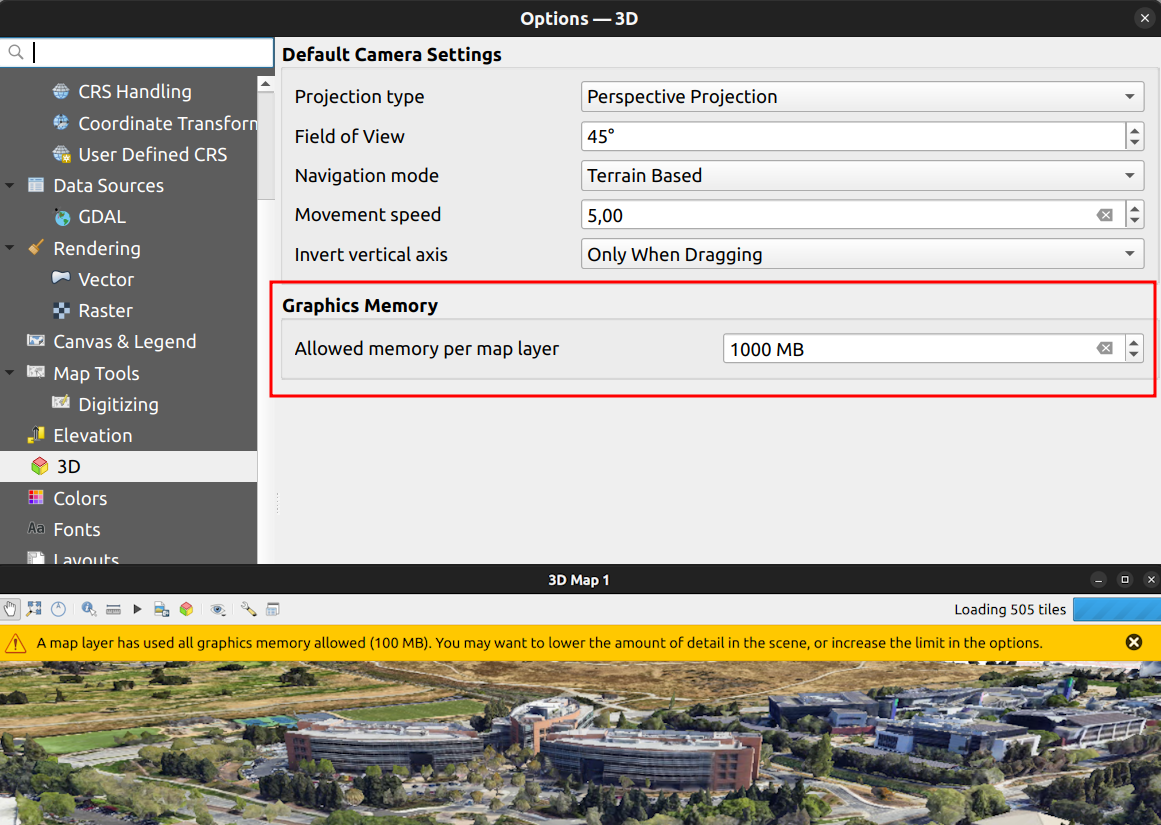
This feature was developed by Martin Dobias
Feature: Add support for boundingbox3d
Additional API methods for relevant geometry classes are now available for boundingBox3D and calculateBoundingBox3D, as well as extensions to boundingBoxIntersects methods which will now support checking intersections between 3D bounding boxes.
This feature was developed by Jean Felder
Tulosteet
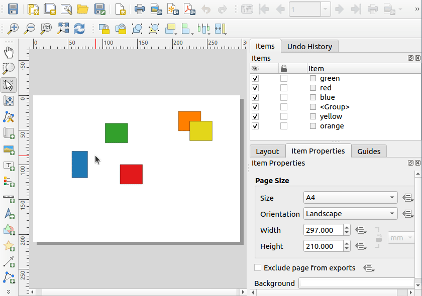
Feature: Select multiple layout items
New functionality is provided for handling the selection of multiple items simultaneously from the item list within print layouts.
This also improves the user experience of multi-select existing functionality which is available with visual selections by keeping the item selection synchronized with the items list.
Tämän toiminnon kehitti Yoann Quenach de Quivillic
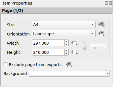
Feature: Layout Page number reflected in page properties
When a layout has more than one page, the current page number will be displayed in the item properties header section using the format page_number/pagecount.
Tämän toiminnon kehitti Yoann Quenach de Quivillic
Feature: Automatically open exported layouts
A new ”Open file after exporting” checkbox option has been added to the export options for PDF, SVG, and Image output types. When selected this option will attempt to automatically open the output file once the export is completed.
The application used to open the file will use the configured default application on the system based on type (using QDesktopServices::openUrl). This feature will leverage the user settings API to remember the selection for the active user profile.
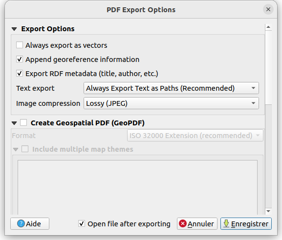
Tämän toiminnon kehitti Yoann Quenach de Quivillic
Lausekkeet
Feature: Add bearing expression function
A new bearing function has been added which computes the bearing angle (in radians) between two points.
The bearing is determined in the given CRS and measured clockwise on the given ellipsoid.
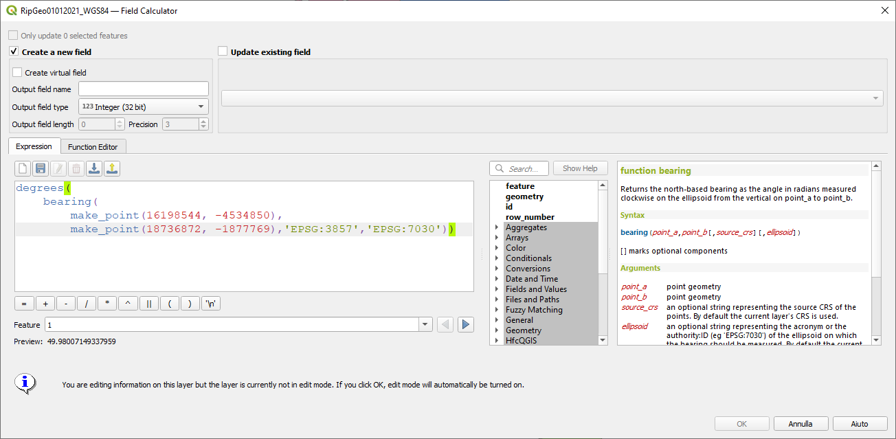
This feature was developed by Andrea Giudiceandrea
Feature: Add ”layer_crs_ellipsoid”
QGIS expressions now include a layer_crs_ellipsoid layer variable, as well as the crs_ellipsoid property available from the layer_property function. The value returned will be the ellipsoid acronym of the layer CRS.
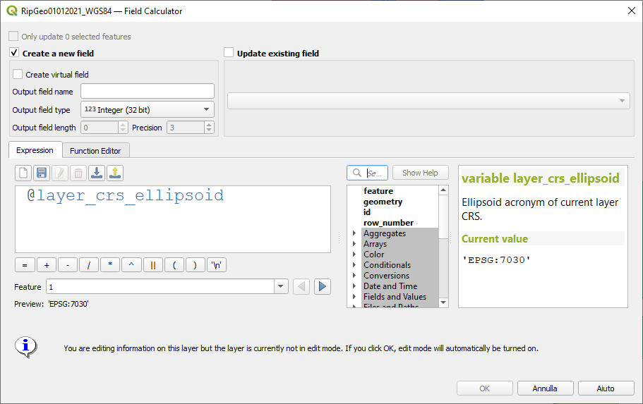
This feature was developed by Andrea Giudiceandrea
Digitointi
Feature: Improve ”avoid overlap” type awareness
When digitizing features with the ”avoid overlap” option, QGIS has improved the behavior of automatically coercing the feature type and includes more meaningful messages to notify users of the automated behaviours.
An example use case would be the digitizing of a multipart polygon on a singlepart polygon target layer, which cannot be saved. QGIS will now automatically only keep the largest geometry portion, and prompt users to optionally restore the additional features as singlepart polygons.
This prevents the digitizing of ”sliver” polygons and frustrations with improper feature types.
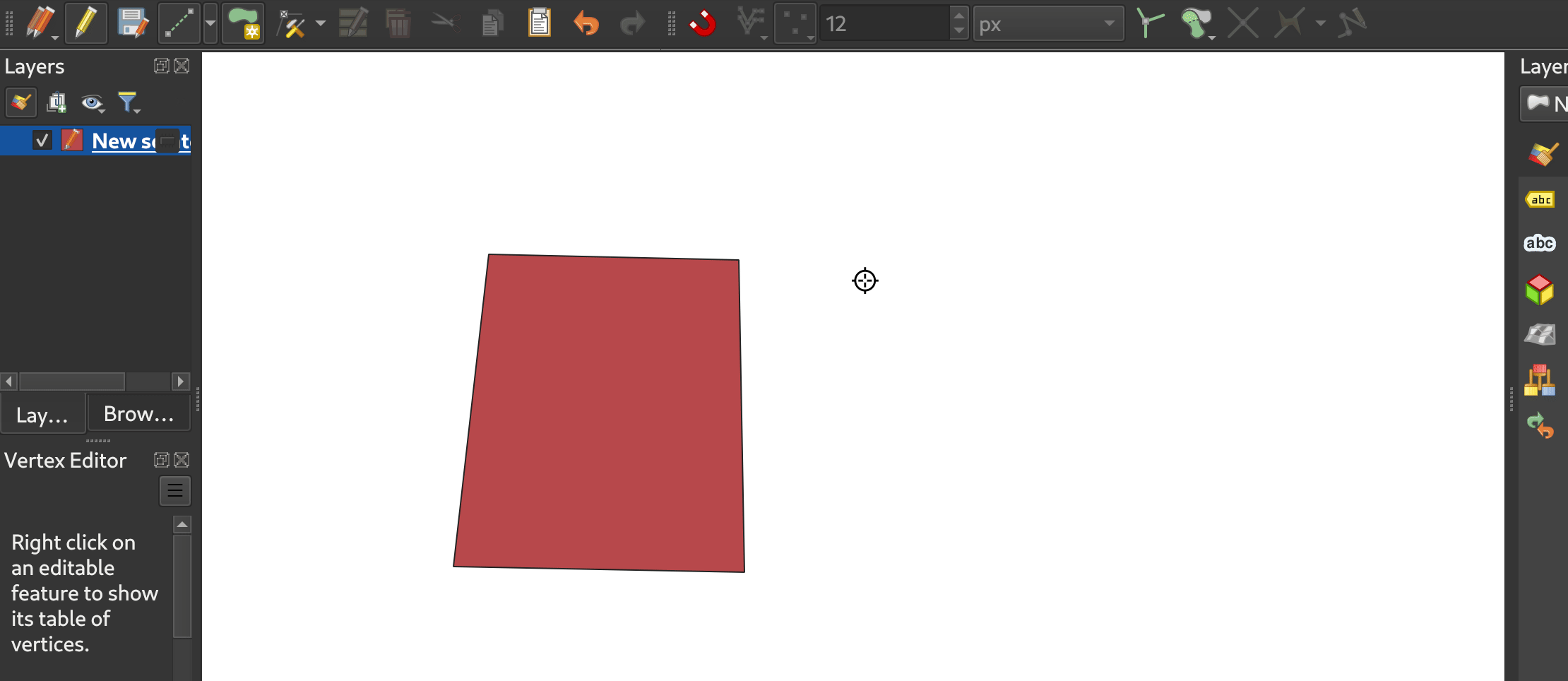
This feature was developed by Matthias Kuhn
Tietojen hallinta
Feature: Improve save vector features handling for pre-existing files
When using the save vector features to file algorithm, QGIS will inform users of the default behavior for handling pre-existing files (file overwrite) and provide the abiltiy to select from a range of alternate behaviors (such as overwrite layer or append new features to existing layer)
This greatly improves the ability for users to manage data using flat file data storage formats such as geopackage, whilst minimizing the risk of data loss or unwanted side effects.
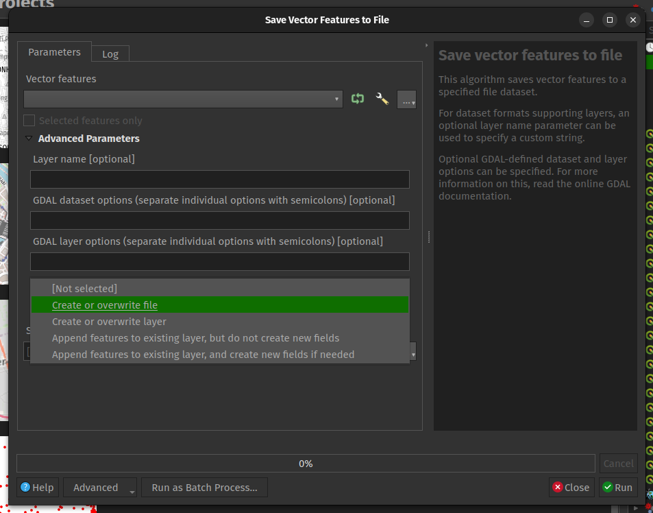
This feature was developed by Mathieu Pellerin
Feature: Maintain relations for copied features
New functionality ensures that copied features within the same layer will continue to respect project relationship(s) strength.
When copying features within the same vector layer using the map, attribute table, or the copy/ move feature(s) tool, QGIS will now track any relationship within the opened project and duplicate features with the relations intact.
This feature was developed by Mathieu Pellerin
Analyysityökalut
Feature: Support raster band description
QGIS will now show band descriptions in the symbology tab for raster layers, in addition to the band number.
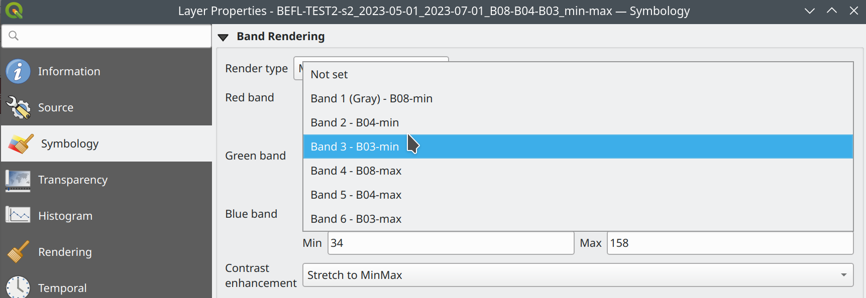
This feature was funded by Summer is getting warmer and warmer.
This feature was developed by Alessandro Pasotti
Prosessointi
Feature: Antialias setting for raster tile processing plugin
A new ”Enable antialiasing” parameter has been added to the ”Generate XYZ Tiles” processing tool.
This option will be enabled by default (replicating the current behavior) but allow users to disable the antialiasing of map content.
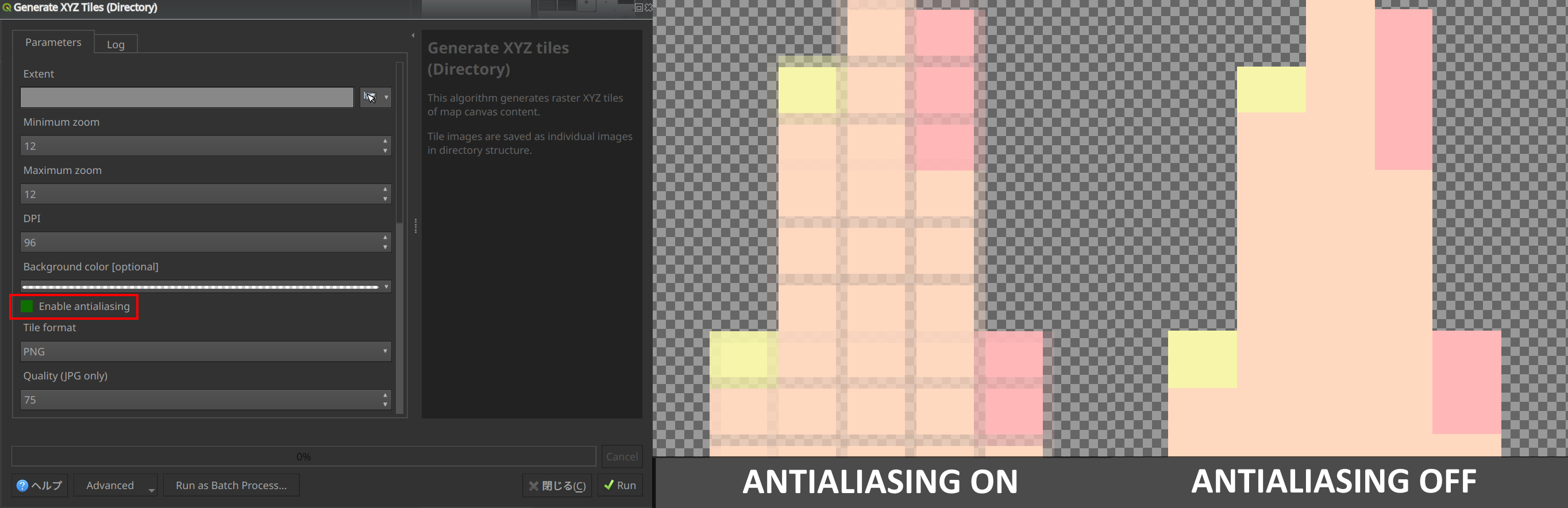
This feature was developed by ASAI Hitoshi
Feature: Create Grid row_index and col_index fields
Fields for the row_index and col_index have been added to the output of the ”Create Grid” processing algorithm. The fields are added to all outputs of type point, rectangle, and hexagon.
Field values are integers for which the count begins at 0 and increments from left to right (column index) and top to bottom (row index).
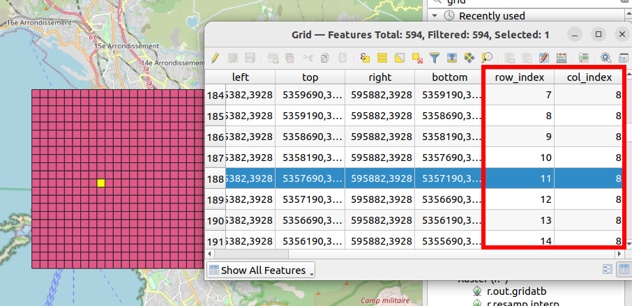
This feature was developed by Valentin Buira
Feature: New ’Calculate expression’ algorithm for use in models
The new ”Calculate expression” algorithm will calculate the results of a QGIS expression and make the result available for use in other parts of the model.
It avoids the need to use the same expression multiple times throughout a model if the same result needs to be used more than once and provides additional use cases (such as generating a static timestamp value for use throughout a model).
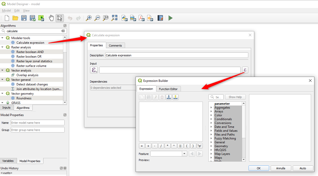
Tämän toiminnon kehitti Nyall Dawson
Feature: Add algorithm to convert content from a GLTF/GLB file to standard vector layer features
QGIS now allows the conversion of 3D tile content in GLTF and GLB formats into editable vector feature formats.
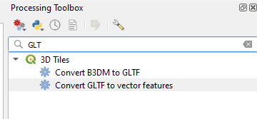
Tämän toiminnon kehitti Nyall Dawson
Feature: Port SAGA ”DTM Filter (slope-based)” tool to a native QGIS algorithm
The SAGA DTM Filter tool has been ported to a native QGIS algorithm.
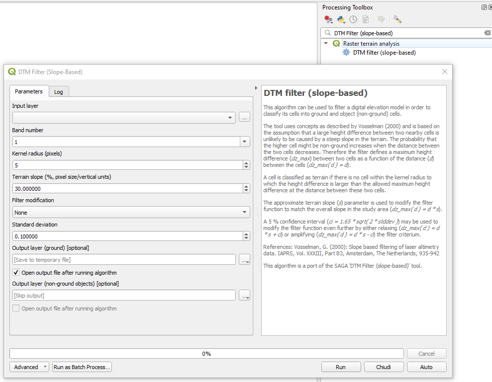
Tämän toiminnon kehitti Nyall Dawson
Application and Project Options
Feature: Clear recently opened project list
A ”Clear Recently Opened” action is now listed at the bottom of the Project → Open Recent menu, which will remove every unpinned project from the menu.
An additional context menu is also available to enable the ability to remove individual projects from the recent project list, as well as ”pin” and ”unpin” items.
The state will be synchronized between the recent projects menu and the QGIS Welcome Page.
Tämän toiminnon kehitti Yoann Quenach de Quivillic
Feature: Set processing defaults from QGIS configuration file
QGIS now supports the capability to configure the default values for GUI tools within the QGIS Processing framework using parameters specified in the QGIS.ini settings file.
This allows for the configuration of user-specific or organization-wide default values for certain algorithms. For example, to set the default value of the GRID_SIZE (precision) parameter on the intersection algorithm, the following configuration may be added to the QGIS/QGIS3.ini in the active user profile directory root:
[Processing]
DefaultGuiParam\native%3Aintersection\GRID_SIZE=0.01
When a user with this configuration opens the relevant toolbox to execute an algorithm, the default value will be specified for them automatically.
This feature was developed by mhugent
Profile Plots
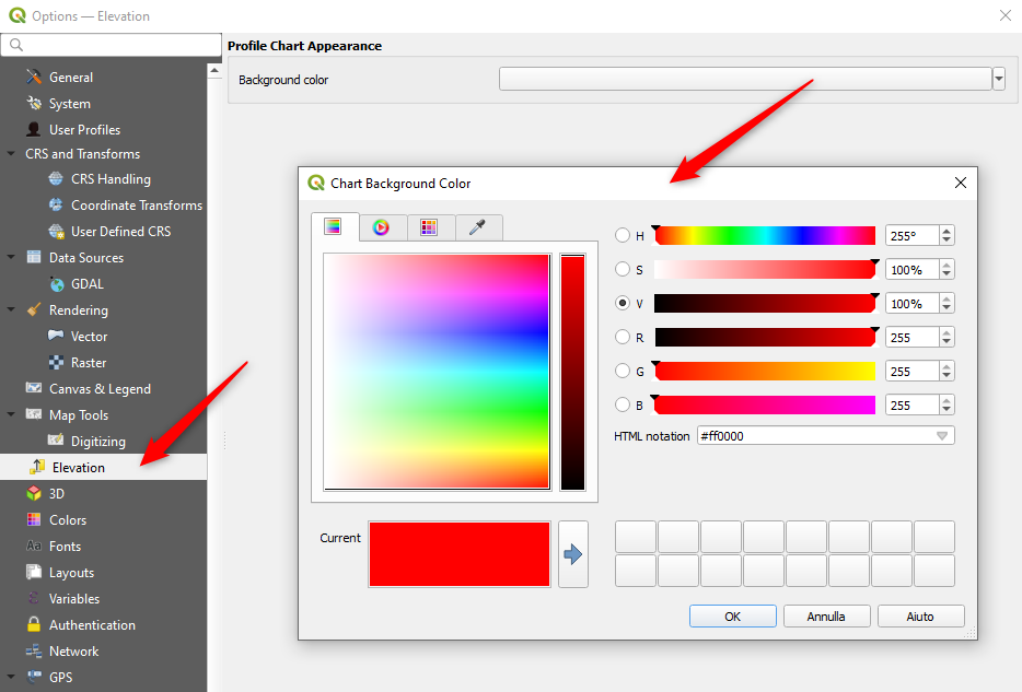
Feature: Add setting to control background color for elevation profile charts
This option (available from the new Settings → Options → Elevation tab) allows users to set a specific color to use as the background color for elevation profiles.
This can make the chart more readable for certain datasets, e.g. point clouds with RGB coloring, where the default background color is too similar to point colors to be easily discernable.
This is an opt-in setting, and by default the elevation profiles will continue to display using the standard system background color.
Tämän toiminnon kehitti Nyall Dawson
Palvelun tarjoajat
Feature: Discover relations for Oracle provider
QGIS now supports the automated discovery of relations for the Oracle data provider.
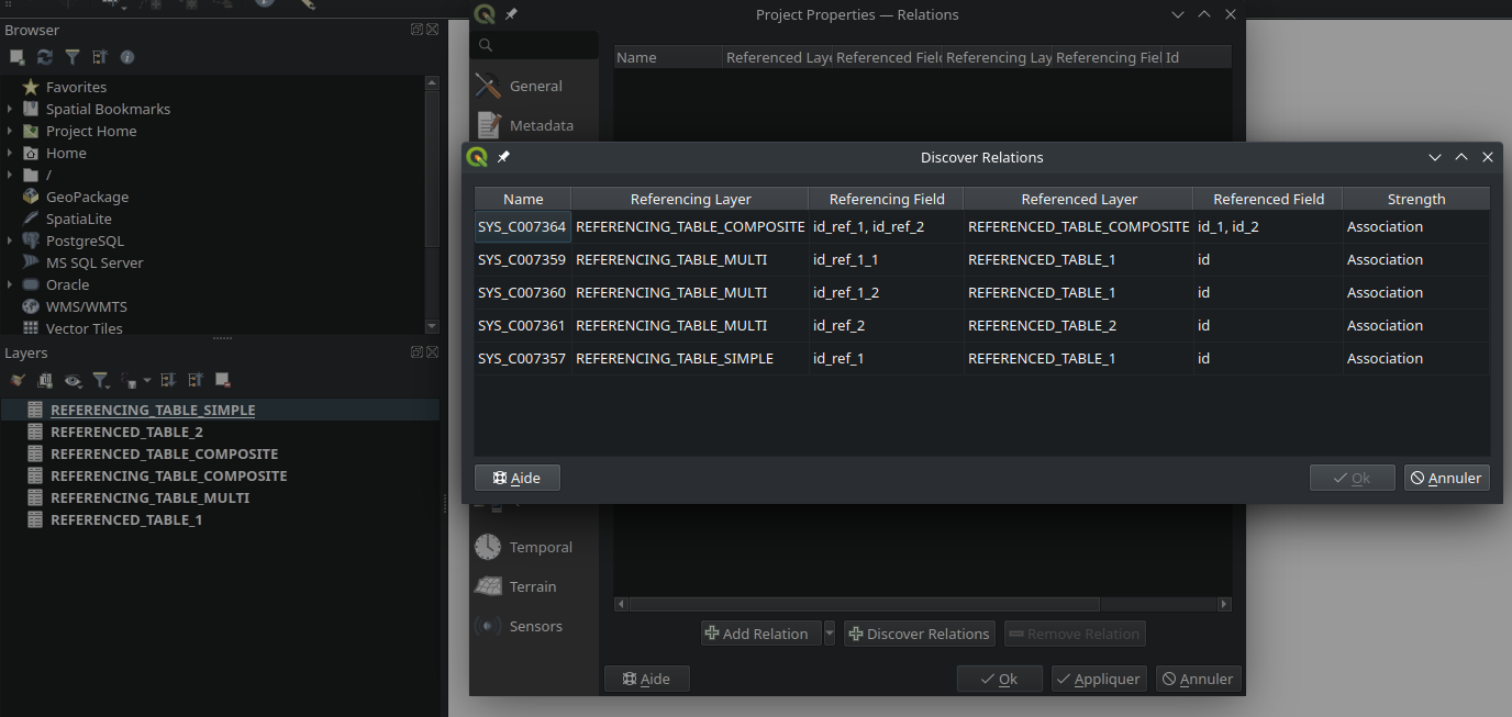
This feature was funded by Métropole de Lille
This feature was developed by Jacky Volpes
Lisäosat
Feature: Drop interactive shell from GRASS C++ Plugin
For maintenance reasons, the interactive shell for the GRASS C++ Plugin, as well as the embedded QTermWidget, have been removed from future releases.
It is expected that the GRASS Processing Plugin will be given priority development and maintenance support going forward, and providing an interactive GRASS shell is not a critical functionality for QGIS itself but rather something that users may manage externally.
Further details on the specifics of this feature cleanup can be found on the feature Pull Request.
Tämän toiminnon kehitti Nyall Dawson
Ohjelmoitavuus
Feature: Function to export runtime profiler model content as text
A new function has been added to allow for the export of the current runtime profiler (QgsRuntimeProfiler) model content as a multi-line text string.
This feature was developed by Mathieu Pellerin
Notable Fixes
Feature: Bug fixes by Alessandro Pasotti (itOpen / qcooperative)
Bug Title |
URL issues.qgis.org (if reported) |
URL Commit (Github) |
3.28 backport commit (GitHub) |
|---|---|---|---|
QGIS cannot connect to MySQL if user’s password contains commas. |
Ei |
||
QGIS WFS server will look for .qgz file in wrong place if ”map” is in path |
|||
Raster layer transparency/opacity not stored in saved style |
|||
WMS GetPrint with ATLAS_PK has incorrect layers visibility in versions >= 3.22 |
|||
Error saving edit on PostGIS geometry when table also contains geography |
|||
Cant subtract or add angles since the degrees symbol has been added |
N/A |
||
WCS Keep Unavailable Layers |
N/A |
||
taxon legend from map whis atlas |
N/A |
||
Spinbox for colum space in legends does not allow to set values above 99.99 units |
N/A |
||
Geometry Error SpatiaLite Database |
N/A |
||
Splitting MultiLineStrings gives awkward results |
|||
Open project, then layer properties, close, close project: qgis thinks something has changed |
N/A |
||
Width field of attribute tables in print layouts only uses locale when being edited |
|||
Data Source Manger - Browser: Close and Help buttons are missing |
N/A |
||
0 port in OAuth2 callback URI |
Cannot reproduce |
N/A |
|
QGIS Crashes when editing multiple features simultaneously that have a Value Relation field |
TODO |
||
Crash when playing with duplicated legends in layout |
|||
QGIS fails to request more than one WMS-Layer |
N/A |
This feature was funded by QGIS.ORG (through donations and sustaining memberships)
This feature was developed by Alessandro Pasotti (itOpen / qcooperative)
Feature: Bug fixes by Even Rouault (Spatialys)
Bug Title |
URL issues.qgis.org (if reported) |
URL Commit (Github) |
3.28 backport commit (GitHub) |
|---|---|---|---|
qgsgeos.cpp: fix a -Wunused-variable warning |
ei-raportoitu |
N/A |
|
qgsvirtualpointcloudprovider.cpp: add a missing variable initialization |
ei-raportoitu |
N/A |
|
OAPIF does not honour the view extent |
|||
Does QGIS require units ”m” for the projection coordinate variables in a netCDF/CF file? |
N/A |
||
Syntactical error with the use of == instead of = for comparison in the WHERE clause |
Already fixed |
Unable to write any additional layers to an existing FGDB |
|
Add minimal CRS information to sqlite exports |
|||
Complex Attributes in OGC API Feature-Items have empty content |
|||
GPX Provider: missing element when importing gpx file |
N/A |
||
Saving edits on larger vector layers is slow |
N/A |
||
QgsVectorLayerSaveAsDialog: uncheck ’Add saved filed to map’ when selecting PGDump driver (refs #54548) |
Not worth it |
||
Spatial filtering of multipart polygons within a shapefile dataset broken |
Not a bug |
||
qgis cannot find/identify a polygon feature by clicking a newly created (multi)polygon part |
|||
qgis cannot find/identify a polygon feature by clicking a newly created (multi)polygon part |
|||
Export to spreadsheet creates an xlsx file with errors when exporting empty tables/layers |
|||
export bbox wrong when feature crosses anti-prime-meridion (180 deg) |
Not worth it |
||
QgsVectorDataProvider.changeAttributeValues() returns True even when it fails |
This feature was funded by QGIS.ORG (through donations and sustaining memberships)
This feature was developed by Even Rouault (Spatialys)
Feature: Bug fixes by Paul Blottiere (Hytech-imaging)
Bug Title |
URL issues.qgis.org (if reported) |
URL Commit (Github) |
3.28 backport commit (GitHub) |
|---|---|---|---|
Fix segfault in coordinate transform |
ei-raportoitu |
N/A |
|
Wrong rendering for HIGHLIGHT_LABEL_ROTATION above 89° |
N/A |
||
Database string connection visible in the message bar/QGIS logs |
N/A |
||
PostGIS Connection’s ”Session ROLE” is not kept |
N/A |
||
Example files are installed by the server build, and additionally they are in a wrong place |
N/A |
||
Point to Path tool causes QGIS to crash |
|||
qgs/qgz project does not save mesh symbology correctly |
N/A |
||
Endless loop if profile is drawn outside layer extent |
N/A |
||
Server: Can’t enable WFS3 API update endpoint (PUT/PATCH) on layers without geometry |
N/A |
||
Add safe guard around -of in gdal command for batch processing |
N/A |
This feature was funded by QGIS.ORG (through donations and sustaining memberships)
This feature was developed by Paul Blottiere (Hytech-imaging)
Feature: Bug fixes by Sandro Santilli (strk)
Bug Title |
URL issues.qgis.org (if reported) |
URL Commit (Github) |
3.28 backport commit (GitHub) |
|---|---|---|---|
Have QgsRectangle null rectangle printed as EMPTY in wkt |
ei-raportoitu |
N/A |
|
Fix aspect ratio computation in QgsLayoutItemMap::zoomToExtent |
ei-raportoitu |
N/A |
|
Do not include a BoundingBox tag in GetFeatureInfo responses, when it is null |
ei-raportoitu |
N/A |
|
Always run the spell and shell checkers if possible, print warning when not possible |
ei-raportoitu |
N/A |
|
Tweak Null rectangle handling |
ei-raportoitu |
N/A |
|
Run spellcheck only on changed files in prepare_commit.sh |
ei-raportoitu |
N/A |
|
Fix prepare_commit.sh |
ei-raportoitu |
N/A |
|
Fix extent computation in QgsSpatiaLiteProvider |
ei-raportoitu |
N/A |
|
Do not force verbose build in mingw build |
N/A |
||
Make QgsBookmark string output more explicit about it being EMPTY |
ei-raportoitu |
N/A |
|
Fix extent computation in QgsAFSProvider |
ei-raportoitu |
N/A |
|
Add |
ei-raportoitu |
N/A |
|
Handle null rectangles in QgsExtentWidget::outputExtent |
ei-raportoitu |
N/A |
|
Handle null in QgsRectangle grow() and include() methods |
ei-raportoitu |
N/A |
|
Add QgsRectangle::setNull(), deprecating setMinimal() |
ei-raportoitu |
N/A |
|
Handle Null rectangle in QgsRectangle::buffered |
ei-raportoitu |
N/A |
|
Fix extent computation in QgsVirtualLayerProvider |
ei-raportoitu |
N/A |
|
Add a QgsRectangle::createNull() temporary static method |
ei-raportoitu |
N/A |
|
Fix testRegisterFeatureUnprojectible - Use valid extent in testRegisterFeatureUnprojectible |
ei-raportoitu |
N/A |
|
Have QgsGeometry::boundingBox return null rect for null geom |
ei-raportoitu |
N/A |
|
Have QgsGeometry::fromRect(NULL RECT) return null geometry |
ei-raportoitu |
N/A |
|
Stop considering Rectangle(0,0,0,0) null - while Rectangle(1,1,1,1) is not null |
N/A |
||
Run doxygen layout checker in prepare-commit script, when possible |
ei-raportoitu |
N/A |
This feature was funded by QGIS.ORG (through donations and sustaining memberships)
This feature was developed by Sandro Santilli (strk)
Feature: Bug fixes by Jean Felder (Oslandia)
Bug Title |
URL issues.qgis.org (if reported) |
URL Commit (Github) |
3.28 backport commit (GitHub) |
|---|---|---|---|
qgs3daxissettings: Correctly read viewport ratio on a saved project |
ei-raportoitu |
This feature was funded by QGIS.ORG (through donations and sustaining memberships)
This feature was developed by Jean Felder (Oslandia)
Feature: Bug fixes by Nyall Dawson (North Road)
Bug Title |
URL issues.qgis.org (if reported) |
URL Commit (Github) |
3.28 backport commit (GitHub) |
|---|---|---|---|
Don’t show help for algorithms which can’t be run in qgis_process |
odottaa |
||
Fix crashes in layout designer |
Too intrusive |
||
Fix layout label adjust size to text logic |
ei-raportoitu |
odottaa |
|
Fix toggling visibility of group layers resets child layer mask blend modes |
N/A |
||
Ensure identify highlight works for very transparent symbols |
|||
Fix layout maps force rasterisation of whole layout when map item has transparency set |
ei-raportoitu |
Too intrusive |
|
Fix crash in merge features dialog when a field has a unique constraint set |
|||
Fix initial zoom level when opening layout designer windows |
|||
Fix hang when exporting 3d maps |
Too risky |
||
Fix layout labels don’t immediately react to changes when semi-transparent |
ei-raportoitu |
||
Fix crash when opening layer properties for raster layer with broken data source |
|||
Fix Execute SQL exeception |
|||
Cleanup all browser layer properties dialog before exiting |
|||
Avoid loss of attributes when calculating fields |
|||
Fix crash when changing layers between editable/non-editable layers |
N/A |
||
Fix QgsField::ConfigurationFlag::None causes syntax error when starting PyQGIS |
ei-raportoitu |
N/A |
|
Handle sql=’’ or sql=”” as empty sql strings instead of ’’ / ”” literals |
|||
Fix crash when certain symbol pages are open in style dock and QGIS is closed or a new project opened |
ei-raportoitu |
Too intrusive |
This feature was funded by QGIS.ORG (through donations and sustaining memberships)
This feature was developed by Nyall Dawson (North Road)
Feature: Bug fixes by Julien Cabieces (Oslandia)
Bug Title |
URL issues.qgis.org (if reported) |
URL Commit (Github) |
3.28 backport commit (GitHub) |
|---|---|---|---|
Masking with SVG symbol doesn’t work |
|||
Bug on graduated symbology on French QGis 3.28.10 |
|||
QGIS crashes when undoing moving of elements in map layout |
|||
QGIS Crashes Upon Exporting Layout to PDF when Using Random Point Fill Symbology |
poly2tri issue https://github.com/jhasse/poly2tri/issues/55 |
||
Label expression with more than 32767 chars becomes invalid when switching from expression dialog back to layer properties |
|||
Activating notify/listen feature crash QGIS |
This feature was funded by QGIS.ORG (through donations and sustaining memberships)
This feature was developed by Julien Cabieces (Oslandia)