QGIS İsviçre’nin Canton Solothurn resmi FOSGIS alanında yer alır
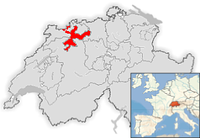
The Canton of Solothurn provides services and infrastructure to 250,000 Solothurn citizens. In the year 2001 the State Parliament decided to migrate from Windows to Linux. The motivations were to be independent from one particular vendor, to encourage free enterprise and reduce license costs. As a result SO!GIS department of the Canton of Solothurn started to deliver the GIS-requirements of more than 3500 employees with a FOSSGIS strategy.
The first step we took was the introduction of UMN MapServer and the creation of a SO!MAP client that offers an easy to use WebGIS client for all the 3500 employees. The second step was the migration of all our geospatial data from Shapefiles to the PostGIS spatial database engine. The introduction was very successful, but an easy to use desktop GIS was lacking.
Farklı CBS masaüstü programının değerlendirilmesinden sonra ESRI ArcInfo ve ArcView3 ün kullanımı 2006 yılnda QGIS ve GRASS birliklte kullanılacak şekilde bırakılmıştır.
Karar aşağıdaki beklentileri karşılamalı:
GIS masaüstü nün Linux Terminal Sunucusu ortamında kullanılması durumunda, Java kullanmak mümkün değildir.
OSGeo Pfoje-Yapısı
GUI Almancaya çevrilmiştir
Dokümentasyon Almanca yazılmıştır
Aktif geliştirici (Marco Hugentobler) İsviçre Solothurn da bulunmaktadır.
Marco Hugentobler ile Harita birleştirme ve Sayısallaştırma gibi kayıp / eksik özelliklerin geliştirilmesi için anlaşıldı.
Pytonla Eklenti ve Uygulama geliştirme
Gelişen kullanıcı topluluğu
Çok aktif geliştirme toplupuğu
Tek bir işletim sisteminden bağımsızlık
QGIS ı nerde kullanırız
In contrast to the interactive maps served by UMN MapServer, the desktop GIS has to offer a flexible view at the geospatial data of Solothurn. QGIS Desktop GIS is in use by more than 50 users for their daily work. But many of them are not GIS experts. They want to visualize and/or capture geospatial data with an intuitive user interface.
One of the most important Desktop GIS issues is the question: “How do I get the information from the PostGIS geodata repository I need?”. Since our end users are unfamiliar with data models and the underlying structures of our spatial database, offering the users a raw connection to the PostGIS DB was not an option. We have a metadata database that stores the descriptions of all production data called ‘SO!DATA’.
SO!DATA contains a human readable inventory of the data models and the non-GIS-Expert user is able to use this database to discover the information they need.
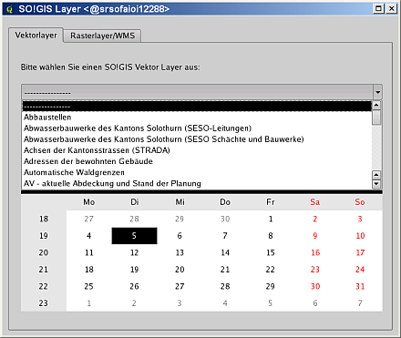
“SO!GIS Katmanı” eklenti Canton Solothurn da geliştirilmiştir
To remove the need for end users to interact directly with PostGIS connections and table selection dialogs, a plugin has been developed in python. The plugin is called “SO!GIS Layer” (see Figure 1). The plugin connects to the SO!GIS PostGIS repository, gets the information of all published geospatial data layers from SO!DATA and offers the user a GUI to find the data layers they need. With this infrastructure in place, our users are happy — they can prepare for geoprocessing, editing and map composing in an individual way.
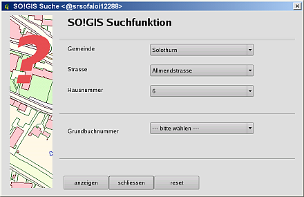
“SO!GIS Suche” eklentisi Canton Solothurn da geliştirilmiştir
Another required QGIS plugin we created is called ‘SO!GIS Suche’. This provides the possibility to search for locations like townships, addresses or cadastral parcels (see Figure 2). As a result the user is able to navigate very easily to an area of interest.
At the moment many other plugins are under development. These will support data manipulation, analysis or mapping for different projects. Our in-development plugins cover topics such as nature reserves, soil conservation, cadastral data verification, crisis management, abandoned sites and so on.
Sonuç
Bugün şunu söyleyebiliriz ki QGIS ı kullanmak bizim için doğru karardı. QGIS kullanıcılarımız tarafından istenilen özelliklerin çoğunu karşılar. Ticari destek sağlayıcıları QGIS
Yazar
Horst Düster
Bu makale Mayıs 2009 yılında Dr.Horst Düster in katkılarıyıla oluşturulmuştur. Kendisi Canton Solothurn da Geoinformasyon bölümünde CBS koordinatördür.