Deneysel ve Uygulamalı Coğrafya Laboratuvarı’nda büyük CBS yazılımı olarak QGIS kullanılmaktadır
Giriş
Laboratory on Experimental and Applied Geography (LEAG) is part of College of Hotel and Business Management, Ltd. In Brno, Czech Republic (Vysoká škola obchodní a hotelová, s.r.o.) which offers higher education at tourism, business and hotel management. LEAG is focused on modeling socio-economic spatial processes, analyzing spatial patterns, describing and monitoring the reality of localities and regions.
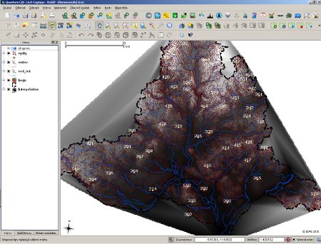
3D nesneleri modellerken QGIS (enterpolasyon), arazi analizi
LEAG plays important role in academic research held in College of Business and Hotel Management. The need of spatial modeling requires also excellent software. The philosophy of minimum cost and maximum efficiency led to choice of open source solutions. This step resulted in using core open source SW such as LibreOffice, GIMP, Inkscape and QGIS. QGIS does not stand alone –– we use MapWindow, OpenJump, gvSIG, SAGA and others. But QGIS plays the major role.
QGIS Kullanımı
QGIS önde gelen yazılımdır ve çeşitli nedenlerden dolayı güncel sürümlerde durmaktadır (LEAG’nin “deneysel” karakterinden dolayı LTS sürümleri yerine en son kararsız sürümleri kullanıyoruz):
Grafik Kullanıcı Arayüzü (ticari ürünlere yakın)
Hızlı gelişme ve kullanıcı tarafından aranan özellikleri entegre etme
Kararlılık ve birlikte çalışabilirlik (Windows ve Ubuntu Linux platformlarını kullanıyoruz)
Diğerleri (örneğin Dr. Horst Düster tarafından yazılan vaka çalışmasında belirtilmiştir)
Spatial analysis are done mainly using basic geoprocessing functions and Python-based plugins. Recent projects where QGIS was used:
Modeling patterns between spatial location and inhabitants
Arazi görselleştirme için (ve daha fazlası tepe gölgeleme) 3D modeller oluşturma
Küçük ve orta boy işletmelerin veritabanlarının saklanması, oluşturulması ve düzenlenmesi (+ daha fazla görselleştirme)
İşletme ve Otel İşletmeciliği Yüksekokulu öğrencileri ve araştırmacıları için ücretsiz kullanılabilen coğrafi bölgelerin homojenleştirilmesi ve “coğrafi veri bankası” oluşturulması
QGIS is used with synergy to other open source products. For example the final layout is mostly create using Inkscape or GIMP (less in LibreOffice Draw). Web-based maps are editing using Inkscape (after SVG export) and raster maps are pre-edited using GIMP.
QGIS is also great educational tool. College of Business and Hotel Management offers students subjects like “Geographical Information Systems I. and II.” or “Selected chapters from geoinformatic literacy” where QGIS is used as main platform for teaching students how to use GIS and how to produce high-quality maps. Recently, the QGIS was used as main product during GIS Day held at our school on November 2010.
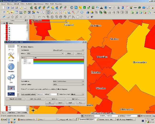
İki nüfus sayımı arasındaki nüfusu karşılaştıran diyagramları kullanma
Sonuç
With no cost and high efficiency the Laboratory on Experimental and Applied Geography produces high-quality analysis, maps and visualizations. Using QGIS large databases are being created and further testing of new functions are being done. Finally, one of the highest impact of using QGIS could be seen in education — QGIS is the first software, which is presented to students. During regular workshops students learn how to legally work with QGIS and how to create their own maps.
Yazar
Jakub Trojan
Bu makale Jakub Trojan tarafından Kasım 2010’da yayınlanmıştır. College of Business and Hotel Management Ltd’de (Brno, CZ) akademik araştırmacı olarak Deneysel ve Uygulamalı Coğrafya Laboratuarını kurdu ve yönetti. Ayrıca Masaryk Üniversitesi Coğrafya Enstitüsü’nde (Brno, CZ) doktora öğrencisi olarak çalışmaktadır.