Список изменений в QGIS 3.14

Release date: 2020-06-19
Еще один великолепный релиз QGIS в серии релизов последних 18 лет разработки. Эта версия переполнена новыми функциями и улучшениями, как большими, так и маленькими. И трудно решить, с чего начать перечисление. Основные нововведения включают поддержку векторных тайлов, огромный прогресс в поддержке mdal / mesh данных, встроенную поддержку временных данных в WMS-T, растровых данные в Postgis, улучшения в векторных провайдерах. Пользователи, занимающиеся картографией и оцифровкой, также не остались без внимания - множество новых возможностей для вас!
Благодарности
Мы хотели бы поблагодарить разработчиков, документаторов, тестировщиков и многих других людей, которые добровольно тратят свое время и усилия (или финансируют людей для этого). От сообщества QGIS мы надеемся, что вам понравится этот релиз! Если вы хотите пожертвовать временем, деньгами или иным образом участвовать в том, чтобы сделать QGIS более мощным, пожалуйста, зайдите на QGIS.ORG и окажите помощь!
QGIS поддерживается меценатами и спонсорами. Текущий список меценатов, которые внесли большой и малый вклад в проект, можно увидеть в нашем списке меценатов. Если вы хотите стать официальным спонсором проекта, пожалуйста, посетите нашу страницу Обзор программы постоянного членства для получения подробной информации. Спонсорство QGIS помогает нам финансировать регулярные встречи разработчиков, поддерживать инфраструктуру проекта и финансировать работы по исправление ошибок. Полный список текущих спонсоров приведен ниже - мы очень благодарны всем нашим спонсорам!
QGIS является свободным программным обеспечением, и вы не обязаны платить за его использование - на самом деле, мы хотим, чтобы люди повсюду использовали его независимо от финансового или социального статуса - мы верим, что расширение прав и возможностей людей с помощью пространственных инструментов принятия решений приведет к улучшению общества для всего человечества.
Общие улучшения
Новые настройки подписей для Сетки Оформления
Подписи сетки оформления карты теперь полностью настраивается, включая цвет шрифта, буфер и т. д.
Спонсорская поддержка - iMHere Asia
Разработчик - Mathieu Pellerin
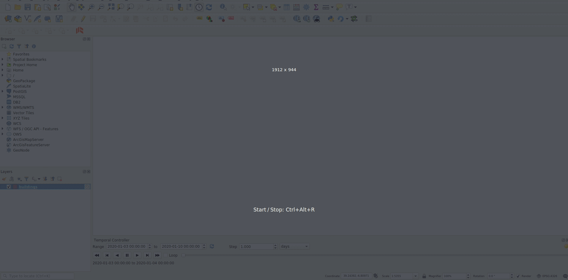
Временны́е данные
Настройка глобального временного диапазона в панели контроля времени
В настройках времени добавлен параметр, позволяющий глобально установить единый временной диапазон анимации. Это означает, что все кадры анимации будут иметь одинаковую дату и время начала, но разные даты и время окончания.
Это полезно, если вы хотите совмещать все данные в визуализации времени, а не показывать скользящее «временное окно» для данных.
Спонсорская поддержка - Метеорологическая служба Канады
Разработчик - Kartoza / Samweli Mwakisambwe
Новый режим «Перерисовывать Только Слой» для временны́х векторных данных
В этом режиме, слой будет автоматически перерисовываться при каждом изменении временного диапазона, но фильтрация по времени к объектам применяться не будет.
Эта конфигурация полезна, когда для слоя установлены настройки символики, которые варьируются в зависимости от временного диапазона. Например, когда слой использует зависящие от времени выражения рендерера на основе правил или определяемые данными выражения символики.
Разработчик - Nyall Dawson
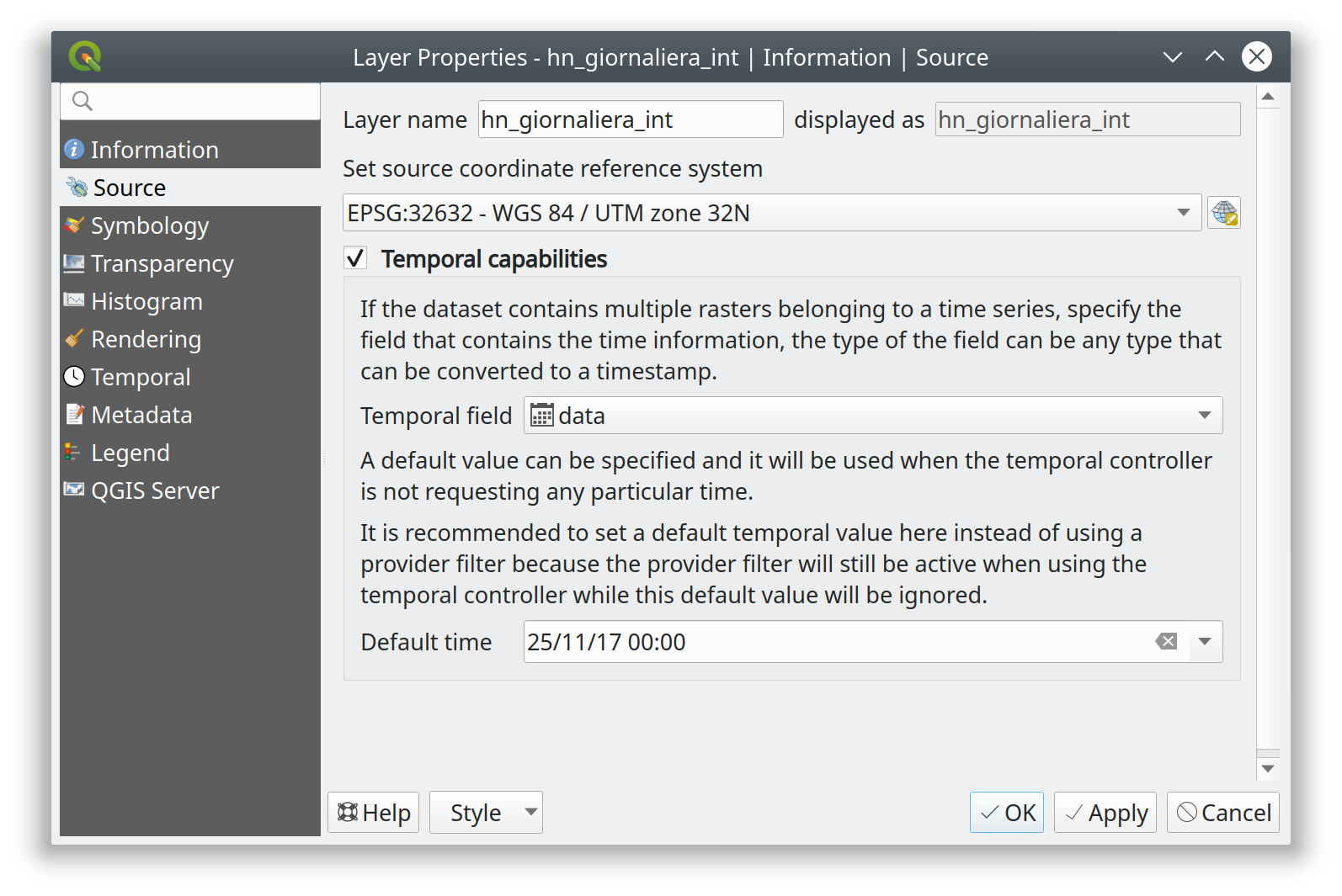
Добавлена базовая поддержка времени для векторных слоев
Это открывает возможность применения для векторных слоев некоторых базовых возможностей временны́х данных:
Статический временной диапазон для слоя (чтобы соответствовать возможностям растрового слоя), это устанавливает один статический временной диапазон, который применяется ко всему слою. Все элементы слоя будут отображаться всякий раз, когда время холста накладывается с временным диапазоном слоя.
«Одно поле с Временем-датой»: позволяет выбрать одно поле Даты или Даты-Времени из слоя. Объекты будут отображаться всякий раз, когда значение этого поля находится в пределах временного диапазона холста
«Отдельные поля для начальной и конечной Даты / Времени»: позволяет выбрать поля для начала и конца диапазона Даты / Даты-Времени для слоя. Элементы будут отображаться всякий раз, когда интервал времени, рассчитанный из этих полей, перекрывает временной интервал холста
Мы предполагаем возможность расширения этого в будущем, например, добавления таких режимов, как «время начала + фиксированная продолжительность», «время начала + длительность из поля», «время начала и окончания через выражения» и т. д.
Некоторые известные ограничения / недоработки:
В настоящее время могут использоваться только поля Date / DateTime. Это было сделано, чтобы упростить обработку формата и избежать необходимости беспокоиться о строковых полях с различными форматами DateTime. В будущем нам следует разрешить выбор строковых полей и разрешить пользователям вводить пользовательскую строку формата DateTime.
В отличие от подхода используемого в плагине Time Manager, мы полностью полагаемся на выражения и функции QGIS для выполнения фильтрации (Time Manager использует строки фильтра слоев и пытается установить нативный синтаксис фильтра SQL, чтобы фильтрация выполнялась на бэкэнде). Это сделано намеренно, поскольку позволяет унифицировать подход к фильтрации независимо от используемого источника (т. е. нам не нужно беспокоиться о различных синтаксисах SQL разных источников данных). Красота выражений запросов объектов должна означать, что выражения QGIS волшебным образом превращаются в собственные внутренние запросы, НОООООООООООО …, поскольку нам пока не хватает поддержки выражений QGIS для форматов DateTime, в настоящее время мы полагаемся на функцию «to _datetime» для приведения всего через строки. Ни один из компиляторов выражений не обрабатывает эту функцию, поэтому в настоящее время *вся* фильтрация выполняется на стороне QGIS. Нам нужно добавить функции для оптимизированного создания DateTime, а затем убедиться, что разные компиляторы правильно переводят это в синтаксис внутреннего фильтра, чтобы вся работа по фильтрации выполнялась на стороне базы данных …
Таким образом, в настоящее время производительность на больших слоях намного хуже по сравнению с Time Manager (и предоставляемый набор функций меньше, например, нет поддержки интерполяции), но преимущество в том, что мы можем использовать собственную временную структуру и анимировать векторные слои вместе с mesh сетками и растровыми слоями!
Разработчик - Nyall Dawson
Поддержка API временны́х растров Postgres
Добавлены возможности интеграции параметра времени для растров Postgres.
Спонсорская поддержка - ARPA Piemonte
Разработчик - Alessandro Pasotti
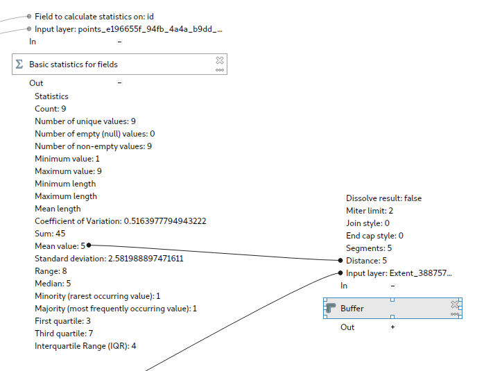
Настройки времени в проекте QGIS
В свойства теперь проекта добавлены настройки времени.
Вы можете установить временной диапазон для проекта посредством ручного ввода, либо путем расчета его из временны́х слоев текущего проекта. Последнее можно сделать, нажав кнопку «Рассчитать из слоёв».
Эта базовая настройка для реализации функций анимации временны́х слоев в QGIS.
Вот пример настройки временного диапазона проекта. 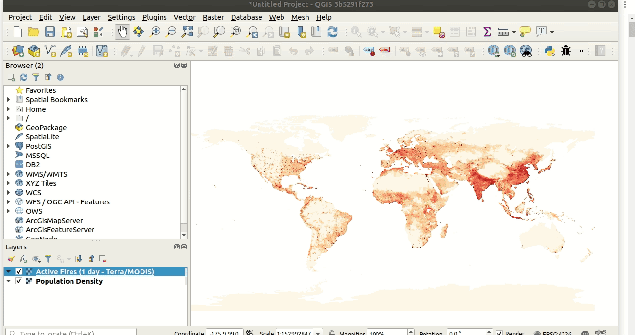
Предыдущие обсуждения о поддержке времени в QGIS можно найти здесь и здесь.
Спонсорская поддержка - Метеорологическая служба Канады
Разработчик - Kartoza / Samweli Mwakisambwe
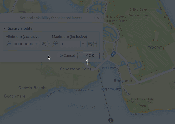
Поддержка временны́х ограничений для WMS-T слоев.
Эта функция добавляет возможность ограничения Временны́х слоев WMS (WMS-T) внутри QGIS. Вы сможете ограничить временной диапазон для любого временно́го слоя из источника WMS-T.
Это позволяет пользователю указать требуемый временной диапазон для слоя на вкладке источника данных в диалоговом окне свойств слоя.
Ниже приведен пример рабочего процесса. 
Примечание: Для запросов определённой точки во времени указание временно́го диапазона с одинаковым началом и концом приведет к использованию указанного момента времени, а не диапазона.
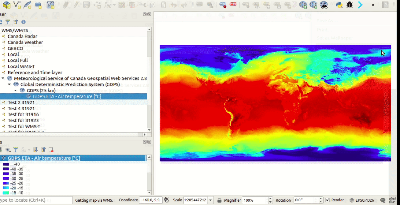
Спонсорская поддержка - Метеорологическая служба Канады
Разработчик - Kartoza / Samweli Mwakisambwe
API временны́х данных
Этот функционал обеспечивает реализацию API для поддержки временны́х данных в QGIS.
Вы можете найти API для Python, выполнив поиск «Temporal» в документации по Python. (ссылка).
Спонсорская поддержка - Метеорологическая служба Канады
Разработчик - Kartoza / Samweli Mwakisambwe
Инструменты карты
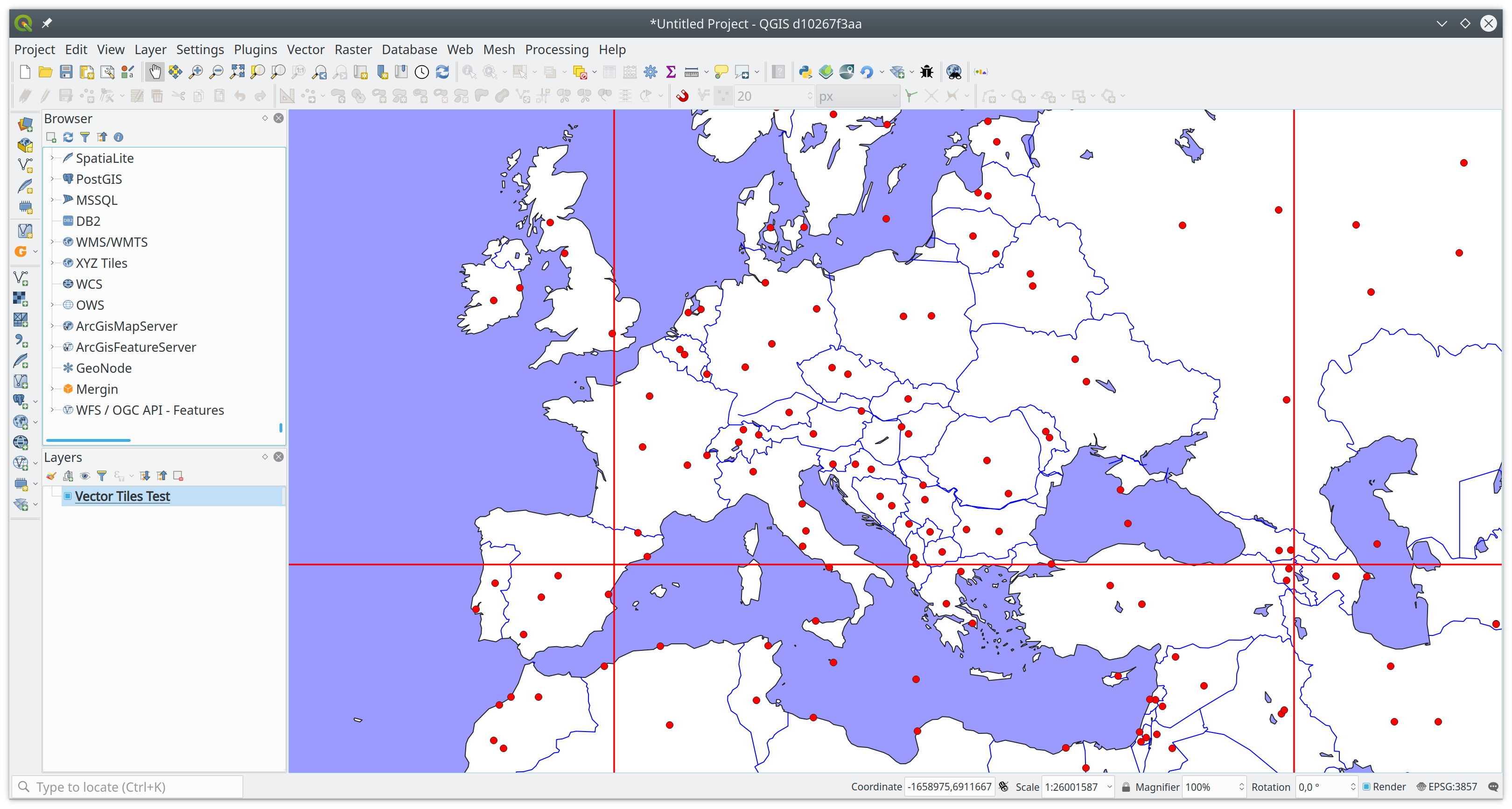
Поддержка Векторных тайлов инструментом Информации об объектах.
Инструмент Информации об объектах теперь умеет показывать атрибуты для объектов на Слое векторных тайлов.
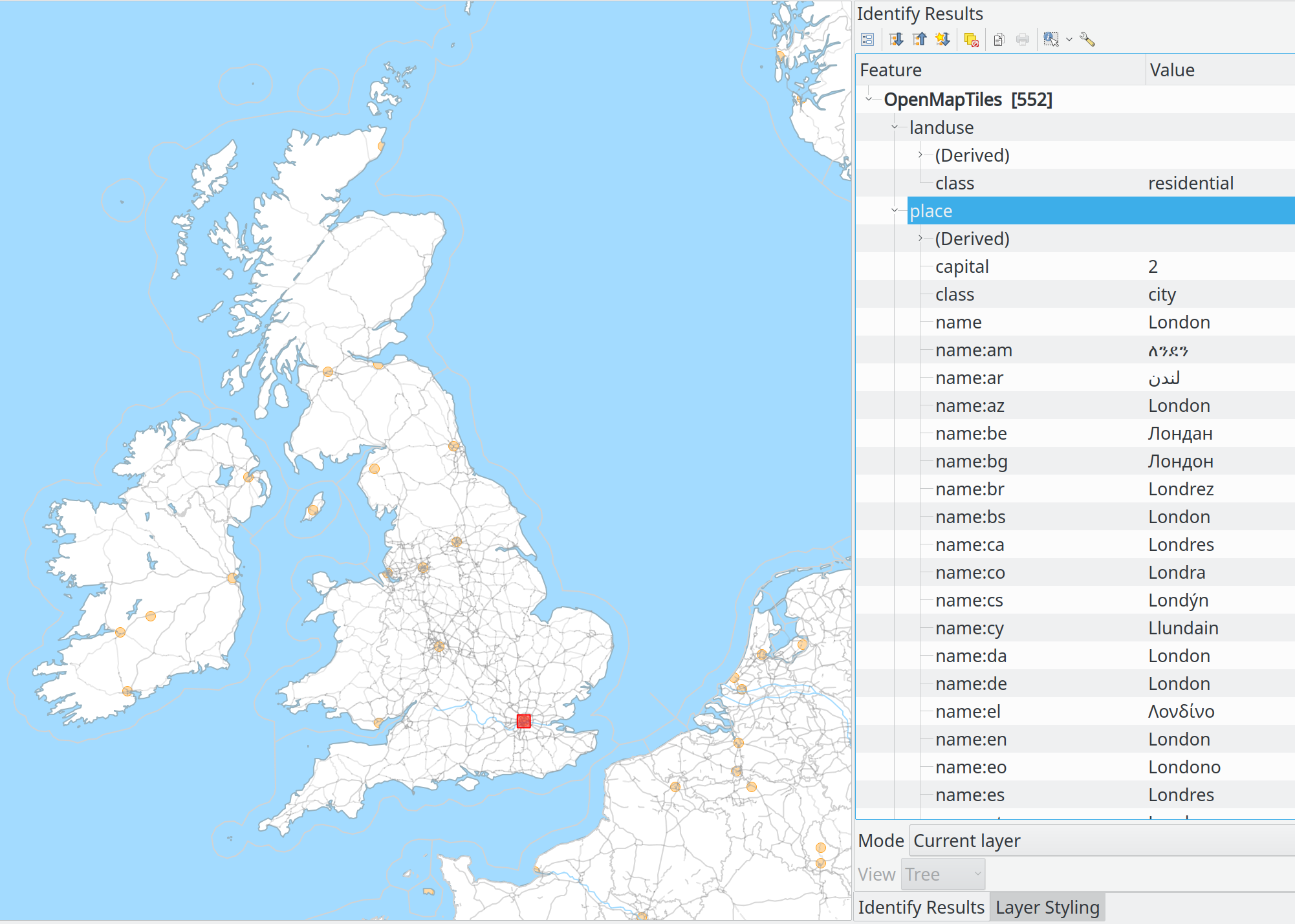
Спонсорская поддержка Множества меценатов
Разработчик - Lutra Consulting (Martin Dobias)
Рядом с кнопками виджета масштаба добавлено меню упрощающее настройку виджета в соответствии с масштабом карты на макете печати.
Наглядная демонстрация вместо тысячи слов:
Разработчик - Nyall Dawson
Добавлена кнопка «Отменить выборку объектов в текущем сло延
Разработчик - Ivan Ivanov
Интерфейс пользователя
Перетаскивание слоёв между разными окнами QGIS
Спонсорская поддержка - Швейцарская группа пользователей QGIS
Разработчик - Denis Rouzaud
Открытие Таблиц Атрибутов в виде вкладок
Если активна опция «Открывать новые таблицы атрибутов как окна док-панели», то они будут открываться в виде вкладок вместе с уже открытыми таблицами.
Разработчик - Germán Carrillo
Оформление
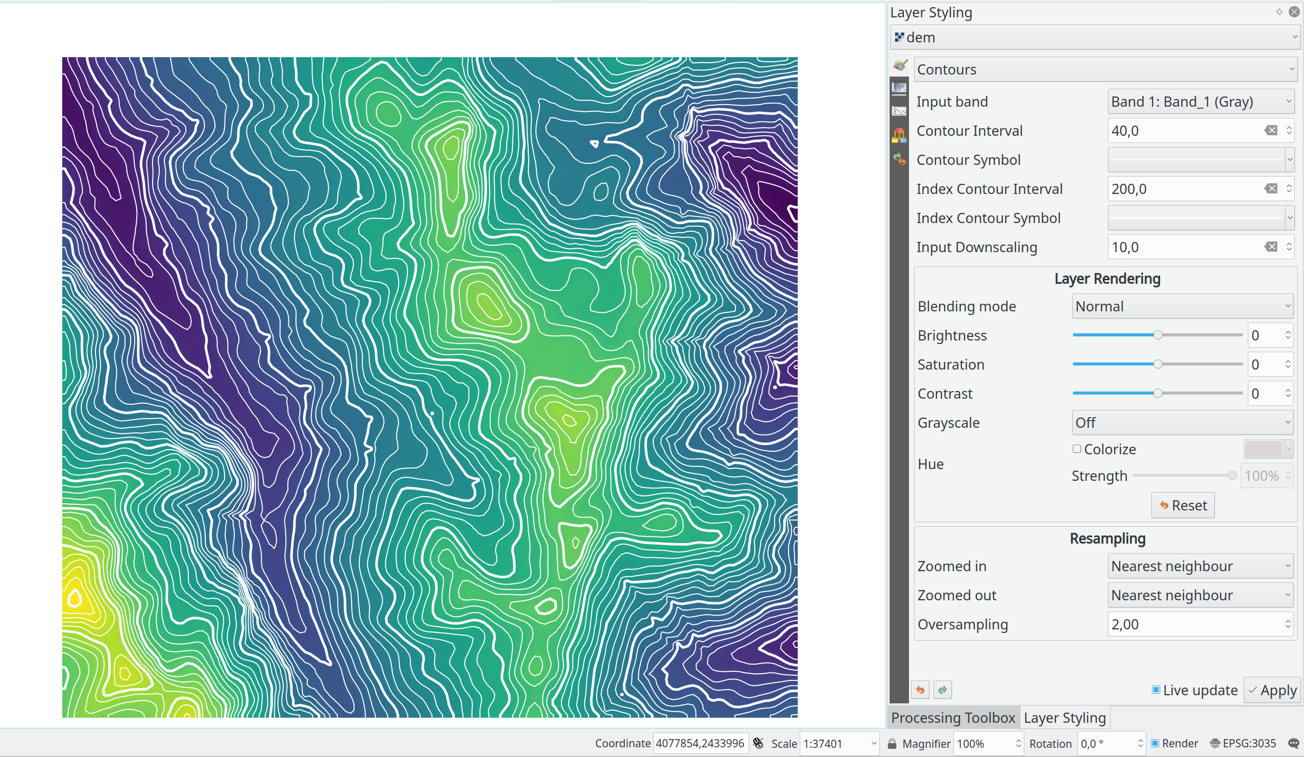
Рендеринг Контуров для Растровых слоёв
Этот новый рендерер рисует контурные линии, которые рассчитываются на лету из исходного растра. Можно установить интервал контурных линий и символ, используемый для рисования.
Кроме того, существует поддержка «утолщённых горизонталей» - контурных линий с более высокими интервалами, как правило, нарисованных с помощью более широкого символа линии.
Если мы сгенерируем контурные линии на входных растровых блоках того же размера, что и наш выходной растровый блок, они будут содержать слишком много деталей. Эта детальность может быть уменьшена фактором «уменьшения масштаба» - это потребует более низкого разрешения исходного растра.
Разработчик - Martin Dobias
Процент добавлен в качестве единицы размера Растрового маркера и Заливки растром.
На основе Запроса этот патч добавляет новое процентное значение (от исходного размера изображения) для единиц размера Растрового Маркера и Растровой Заливки (by nirvn suggestion) слоёв.
Например, слой содержит растровые изображения различных размеров и соотношений сторон:


Если мы используем Растровый маркер с единицами размера по умолчанию, слой будет выглядеть следующим образом (с обычным крокодилом, но огромным жирафом):
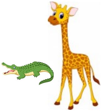
или вот так (с обычным жирафом, но крошечным крокодилом):
Новая процентная единица измерения предназначена для решения этой проблемы.
Оба модульных теста «qgis _rasterfilltest» и «qgis _rastermarkertest» были переписаны с набором новых контрольных изображений для проверки предлагаемого процентного значения единиц измерения.
Разработчик - beketata
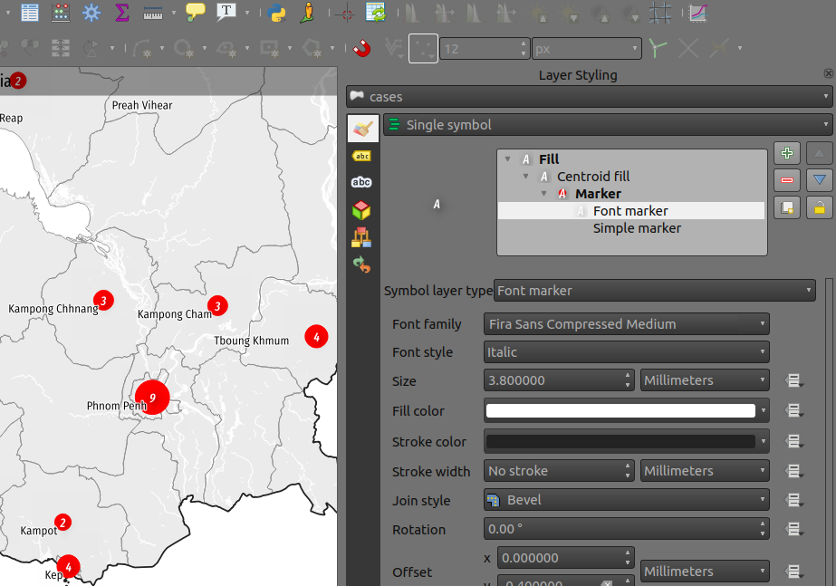
Возможность назначать Семейство шрифтов / Стиль для Символьного маркера на основе формульных данных.
Возможность назначать свойства на основе формульных данных, была добавлена для параметра Семейство шрифтов и нового свойства Стиль шрифта для Символьного Маркера. Это может пригодиться в ряда сценариев, включая многоязычный контекст, где свойство, определяемое данными, может помочь избежать дублирования.
Спонсорская поддержка - iMHere Asia
Разработчик - Mathieu Pellerin
Новое свойство Стиль шрифта для Символьного маркера
Благодаря этой новой настройке Cтиля шрифта пользователи могут выбирать нестандартные семейства шрифтов, ранее недоступные.
Спонсорская поддержка - iMHere Asia
Разработчик - Mathieu Pellerin
Подписывание
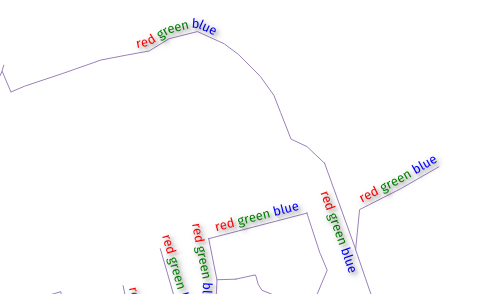
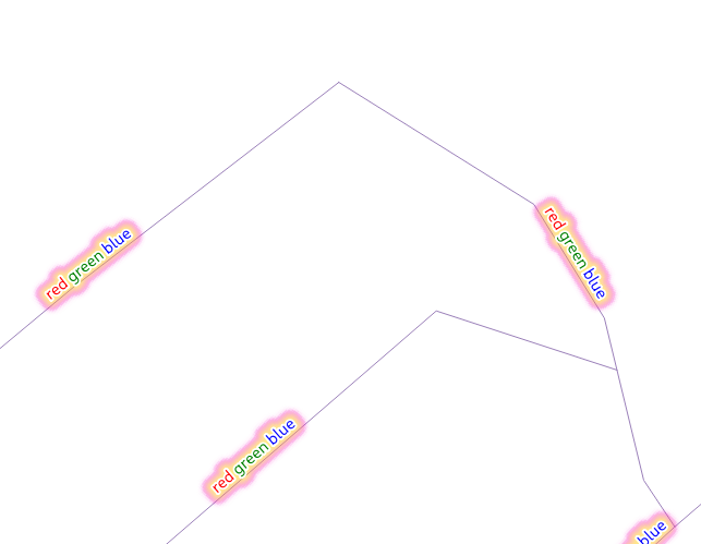
Цвета в нотации HTML в Подписях
Если включен, этот параметр будет обрабатывать содержимое подписи как HTML, и любые свойства форматирования HTML, относящиеся к ЦВЕТУ ОБЪЕКТОВ ПЕРЕДНЕГО ПЛАНА, будут учитываться в отображаемой подписи.
Примечание: ОБРАБАТЫВАЮТСЯ ТОЛЬКО ТЕГИ ЦВЕТА HTML. Это НЕ ошибка, скорее эту опцию надо рассматривать как «первый тест» HTML форматирования в Подписях, и, соответственно, были затронуты только параметры форматирования, которые не изменяют форму шрифта.
С другой стороны, это корректно работает со ВСЕМИ другими настройками подписей, включая тени, буферы, изогнутые метки и т. д.!
И несколько красивых картинок:
Спонсорская поддержка - geoProRegio AG
Разработчик - Nyall Dawson
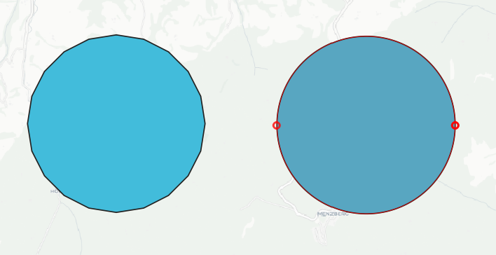
Автоматическое размещение подписей за границами полигонов
Эта функция добавляет возможность автоматического размещения подписей вне полигональных объектов.
Это проявляется несколькими способами:
Новый режим размещения, который всегда располагает подписи полигонов для слоя вне объектов:
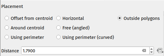
При использовании других режимов размещения подписей для полигонов можно установить новый флажок «Разрешить размещение подписей вне полигонов», чтобы разрешить размещение подписей снаружи, когда их невозможно разместить внутри многоугольника:
Опция «Разрешить размещение подписей снаружи» может быть задана на основе формульных данных, что позволяет пользователям либо разрешать подписи снаружи, либо запрещать размещение подписей снаружи, либо определять возможность размещения подписи снаружи пообъектно.
Алгоритм размещения реализован модификацией алгоритма Rylov & Reimer (2016) «* Практичный алгоритм для внешнего подписывания областей *». Хотя Rylov & Reimer предлагают подход, основанный на горизонтальной линии разметки, для выбора точек-кандидатов, на практике я обнаружил, что это дало худшие результаты (и было медленнее), чем просто обход внешнего кольца многоугольника и генерация точки-кандидата через равные промежутки (особенно для узких, почти горизонтальных полигонов).
Как показано на иллюстрации выше, режим внешнего размещения, как и ожидалось, работает в том числе вместе с опцией многострочного выравнивания «Отслеживать размещение подписей».
Спонсорская поддержка - Швейцарская группа пользователей QGIS
Разработчик - Nyall Dawson
Векторные тайловые слои - часть 4 (подписывание)
Продолжается работа по поддержке векторных тайловых слоёв.
Это добавляет поддержку подписывания для векторных тайловых слоев. Пока это работает только работает на уровне ядра программы… реализация в пользовательском интерфейсе ожидается в ближайшее время. Подписывание строится на тех же принципах, что и рендеринг векторных тайлов: у нас есть список стилей для подписей, каждый из которых определяется именем подслоя, типом геометрии, выражением фильтра, диапазоном масштабирования и, конечно, конфигурацией стиля подписи (QgsPalLayerSettings).
Обратите внимание, что имеется «проблема курицы и яйца» с подписыванием: для векторных тайлов мы создаем QgsFields для подслоя на основе полей, которые отображают и запрашивают подписи, но с подписыванием было невозможно получить обязательные поля, если они не были уже доступны в контексте выражения для подписи (отсюда несколько небольших дополнений к QgsProperty, QgsPropertyCollection, QgsPalLayerSettings, чтобы иметь возможность получать требуемые имена полей, не готовя при этом внутренние выражения одновременно).
Пример того, как включить вышеупомянутое подписывание из консоли Python:
s = QgsVectorTileBasicLabelingStyle()
s.setLayerName("place")
s.setGeometryType(QgsWkbTypes.PointGeometry)
s.setFilterExpression("rank = 1 AND class = 'country'")
ls=QgsPalLayerSettings()
ls.drawLabels=True
ls.fieldName="name"
ls.placement = QgsPalLayerSettings.OverPoint s.setLabelSettings(ls)
labeling = QgsVectorTileBasicLabeling()
labeling.setStyles([s])
iface.activeLayer().setLabeling(labeling)
Спонсорская поддержка Множества меценатов
Разработчик - Lutra Consulting (Martin Dobias)
Дополнительный контроль над узловой точкой для выноски подписи
Это дает пользователям управлять тем, где выноска должна присоединяться к тексту подписи (ранее у вас был только контроль над тем, где выноска будет присоединяться к соответствующей геометрии объекта).
Выбор включает в себя следующие варианты:
Ближайшая точка (ранее реализованное поведение)
Центроид Подписи
Фиксированные углы: Вверху слева/Вверху справа/Внизу слева/Внизу справа/и т. д.
Также возможно управление привязкой подписи на основе формульных данных.
Помогает исправить некоторые неряшливые выноски!
Результат работы старого алгоритма (режим ближайшей точки):
Новый вариант размещения на основе «центроида»:
Разработчик - Nyall Dawson
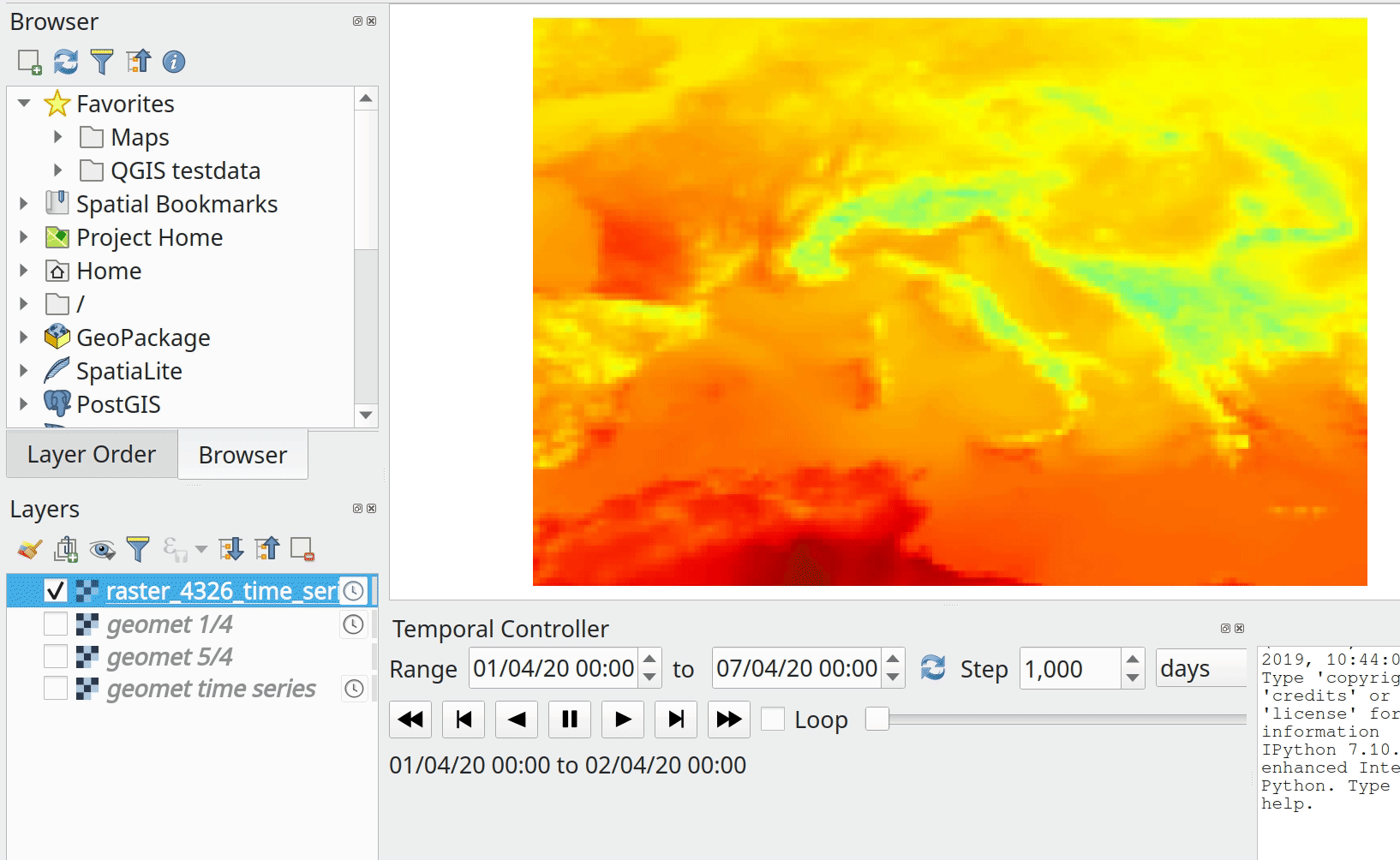
Mesh данные
Feature: Use only specified dataset group
This feature allows the user to choose the dataset groups that are used. This can be done in the mesh layer properties dialog in the source tab.
A new tree view displays all the available dataset groups from the data provider. The dataset groups can be checked/unchecked and renamed.
This widget also provides buttons to load extra dataset groups from files, to expand/collapse the tree, to check/uncheck all items and to reset the defaults from the provider (for now, only the original name).
Only the checked dataset group will be displayed in the active dataset widget in renderer settings.
Спонсорская поддержка - Deltares
Разработчик - Lutra Consulting (Vincent Cloarec)
Скалярные настройки цвета в зависимости от классификации
С помощью этой функции, MDAL считывает классифицированные скалярные значения в наборе данных. Когда значения классифицируются, в настройках скалярного рендеринга по умолчанию используются градиент и метки, установленные в соответствии с классифицированными значениями.
Спонсорская поддержка - Deltares
Разработчик - Lutra Consulting (Vincent Cloarec)
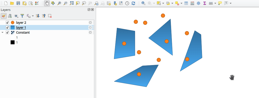
Привязка к элементам mesh
В API добавлены методы для реализации привязки к элементам mesh сетки.
Метод возвращает позицию привязанной точки на ближайшем элементе mesh сетки:
Для вершины позиция привязки - это позиция вершины
Для ребра позиция привязки - это проецируемая точка на ребре, или край ребра, если за пределами ребра
Для грани позиция привязки - это центроид грани
Позиция возвращается в координатах карты.
Спонсорская поддержка - Deltares
Разработчик - Lutra Consulting (Vincent Cloarec)
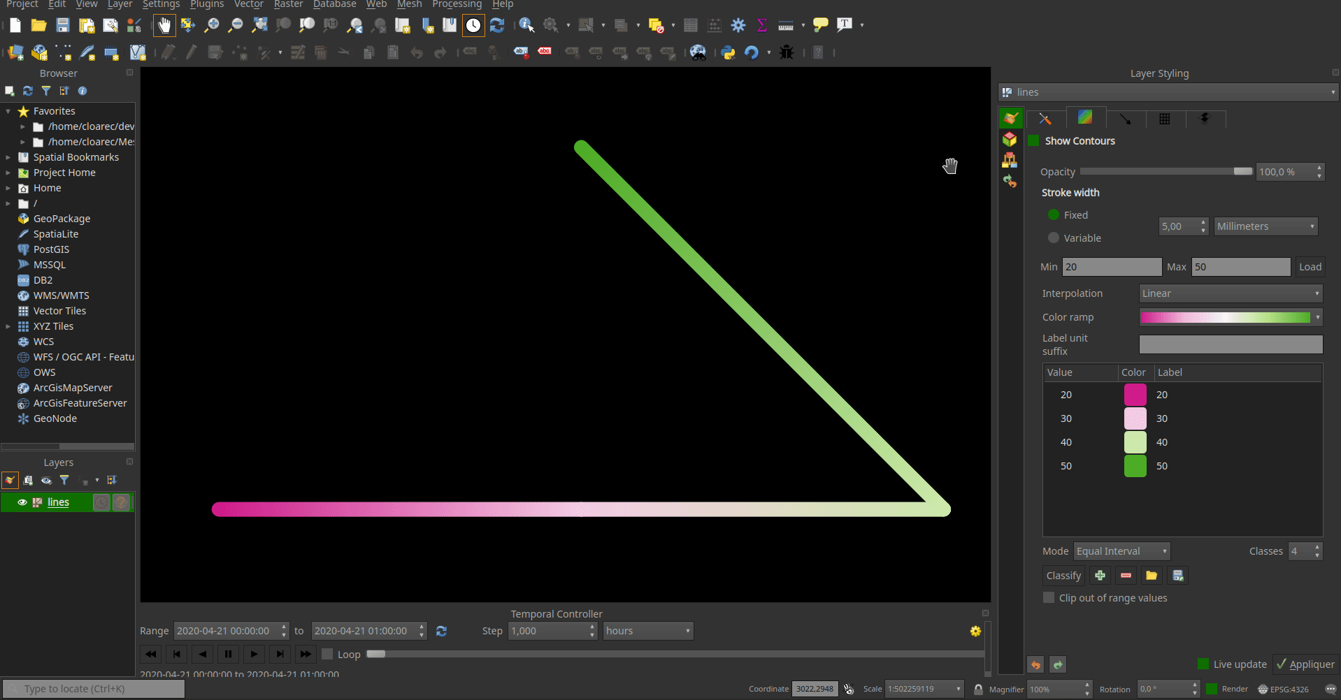
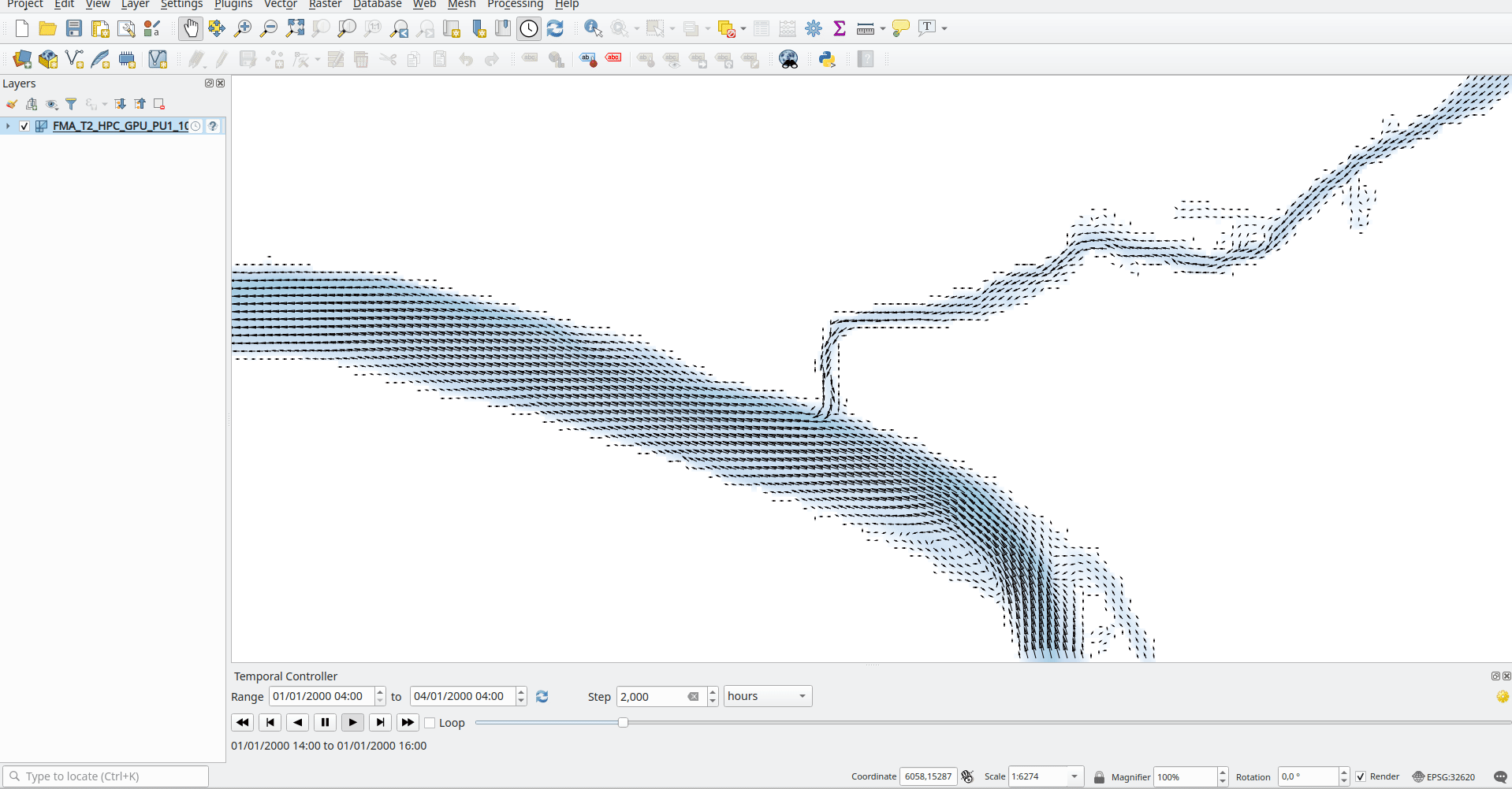
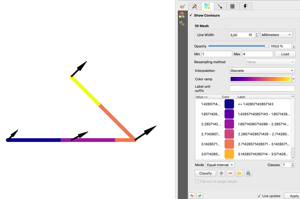
Feature: 1D mesh width/color varying
This feature provides a new way to render a 1D mesh with edge widths that can vary depending on value. So now, width and color vary depending on the value on the edges or on vertices.
The user can define min/max value and min/max width to set the rendering.
For color, the user can define a color ramp shader (as for 2D mesh and raster).
For this new rendering, new generic classes are introduced that could be used outside the mesh framework.
Спонсорская поддержка - Deltares
Разработчик - Lutra Consulting (Vincent Cloarec)
Feature: Support for multiple mesh (since MDAL 0.5.91)
In addition to updating to MDAL 0.5.91, this feature allows several meshes to be loaded from one file.
The file is parsed and a sub layer dialog is launched using the same logic as for vector or raster layers.
Спонсорская поддержка - Deltares
Разработчик - Lutra Consulting (Vincent Cloarec)
Feature: Plug mesh layer to QGIS temporal framework
Time handling in mesh layer
The time in a mesh layer is defined by :
A reference time provided by the data, the project or the user
Each dataset is associated with relative times
Time extent is defined by the first time and the last time of all datasets
Reference time :          AT
Dataset 1 time            o---RT------RT-----RT-----------RT
Dataset 2 time            o-------RT------RT--------RT
Dataset 3 time            o--------------------------RT-------RT------RT
Time extent of layer      o----<---------------------------------------->

-  AT : absolute time (QDateTime)
-  RT : relative time (qint64)
The class QgsMeshDataprovidertemporalCapabilities stores the reference time provided by the data and all the relative times of the dataset. This class has the ability to return dataset index from a dataset group index and a relative time since the reference time. The reference time (which can be different than the provider reference time) and the absolute time extent are stored in the class QgsMeshTemporalProperties
The temporal settings in the properties widget are only the reference time and the provider time unit: 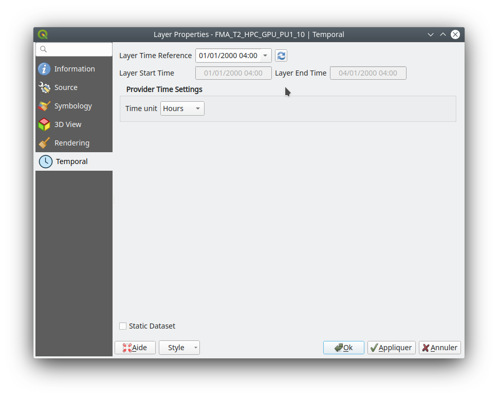
The default reference time of the layer is set by (sorted by priority):
From the data provider if defined in data
From the project if defined
From current date with time 00h00
The user can change it if he wants.
Rendering principle
The 2D and 3D renderers access the active dataset index from the layer with the time range stored in the QgsContextRenderer and in the Qgs3DMapSettings : Relative time is calculated as the difference between the time range of QgsContextRenderer and the reference time stored by QgsMeshTemporalProperties. The dataset index comes from the QgsMeshDataproviderTemporalCapabilities that maps the relative time with dataset index.
The data are brought from the provider with the dataset index.
Static dataset
There is also the option to set a static dataset, that is to choose a dataset that will be rendered independently of the QGIS time controller. To do that the user can check the check box at the bottom of the temporal page of the properties widget: 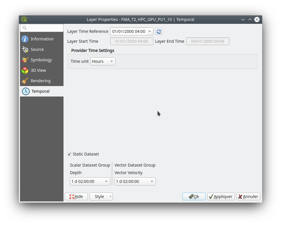 For now, as it was simpler to implement and allows the required dataset to be chosen directly, the user can independently choose scalar dataset and vector dataset from combo boxes with the time associated for each dataset (relative time for data without reference time). If required, a unique time could be implemented but that could lead to inconsistent results with non synchronous datasets. The static dataset settings are in the temporal page but can be easily put in the source page if wanted.
Спонсорская поддержка - Lutra Consulting
Разработчик - Lutra Consulting (Vincent Cloarec)
Feature: Resampling from vertex values to face values
Resampling is available for datasets defined on faces, e.g. the value on vertices is calculated from values on faces.
This feature implements resampling from values on vertices to values on faces using the neighbor average method.
The default method is set to «none» for resampling from vertices to faces and to «neighbor average» for resampling from faces to vertices. Then the default rendering is always smooth. 
Разработчик - Lutra Consulting (Vincent Cloarec)
Feature: Coloring mesh vector dataset with color ramp shader
This feature allows the user to color the mesh layer vector dataset (arrow, stream lines, traces) with the color ramp shader depending on the magnitude of the vector.
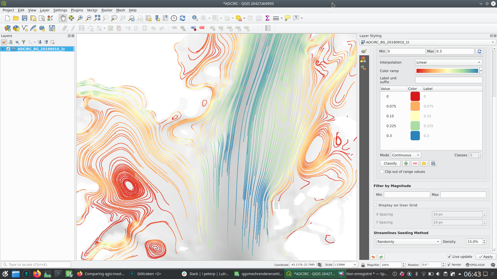
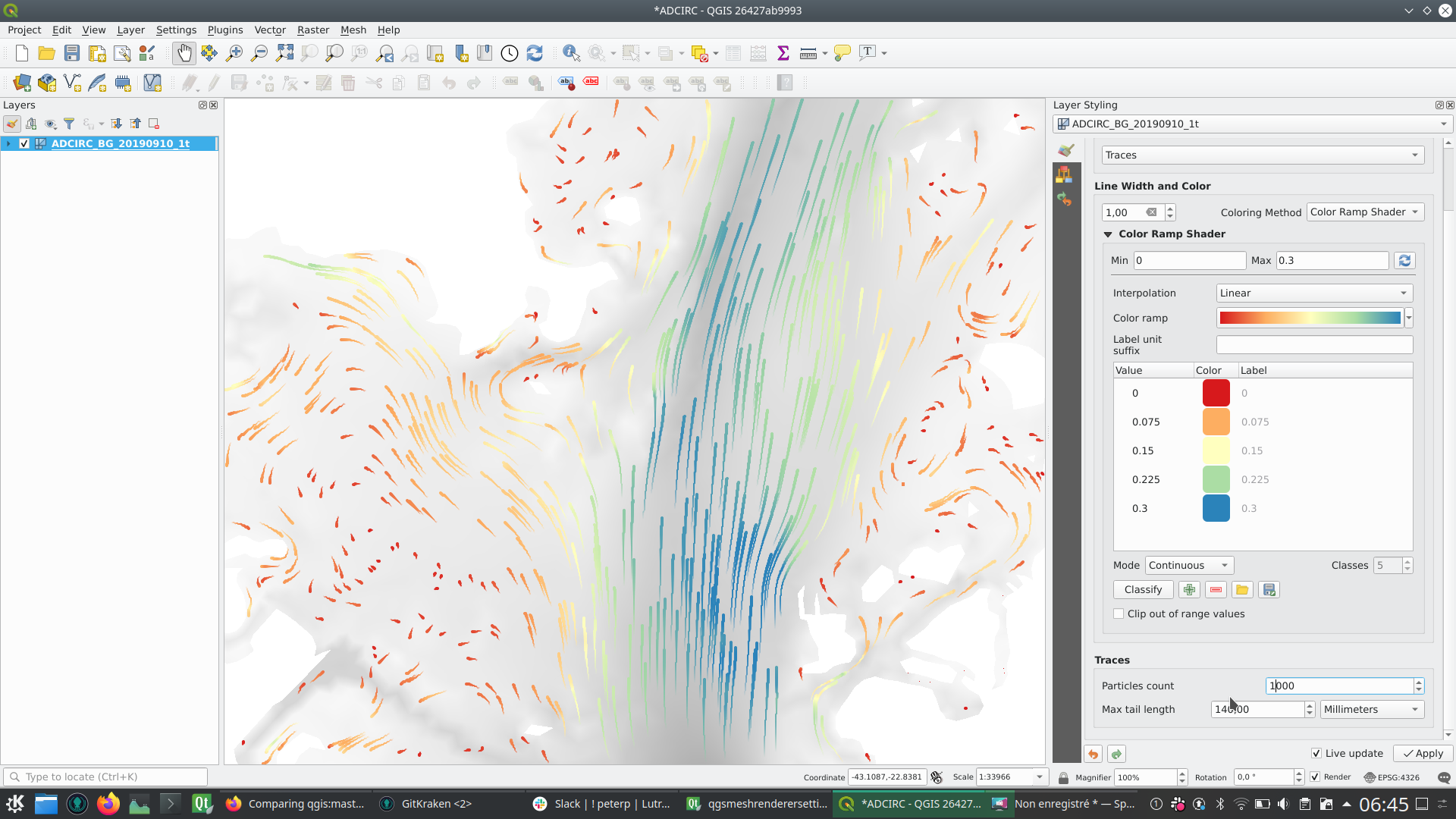
Спонсорская поддержка - Deltares
Разработчик - Lutra Consulting (Vincent Cloarec)
Feature: Save style for mesh layer
This feature adds the option for saving a mesh layer style in a qml file, as utilised for vector and raster layers.
The feature also refactors the raster and vector layer properties menu style. 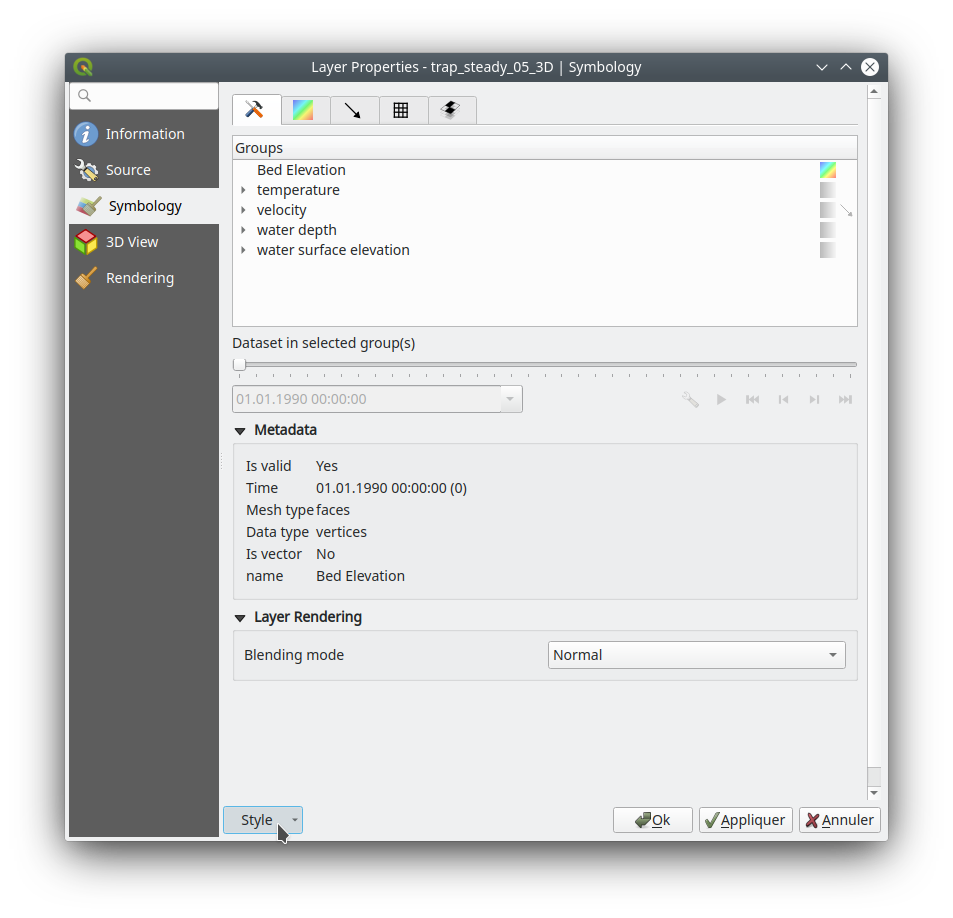
Спонсорская поддержка - Artelia Group
Разработчик - Lutra Consulting (Vincent Cloarec)
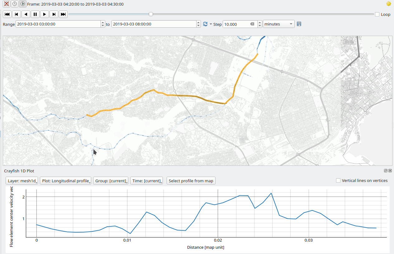
Feature: Mesh 1D Renderer
Обновление MDAL до 0.5.90
Первичная реализация Поддержка 1D элементов в слоях Mesh сетки
1D Meshes consist of vertices and edges. An edge connects two vertices and can have assigned data (scalars or vectors) on it. The 1D mesh network can, for example, be used for modelling an urban drainage system.
There are new options to display 1D mesh (edges) in the mesh frame tab 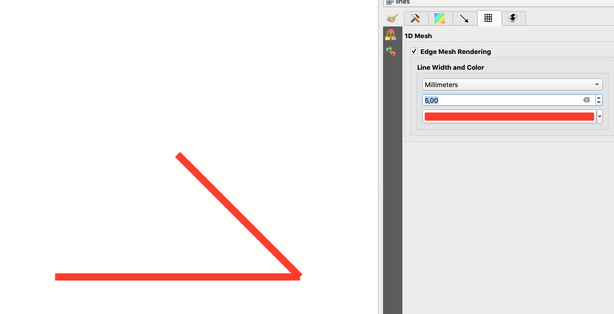
Also for data on 1D mesh (edges or vertices) there are new options in the contours tab
Note that not all functionality available for 2D meshes is available, notably
Support for Mesh Calculator for 1D meshes
3D rendering of 1D meshes
Identify and Plots in Crayfish (will be added later in the following PR)
Some functions are not necessary for 1D meshes, especially
Export of mesh contours
Разработчик - Peter Petrik
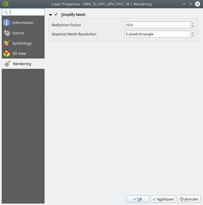
Feature: Mesh simplification
As a mesh layer could have millions of triangles, rendering can be very slow, especially as all the triangles are displayed in the view even when triangles are too small to be seen.
For those situations, this feature provides an option to simplify the mesh. Simplification leads to one or more simplified meshes that represent levels of detail. When rendering the mesh, the appropriate level of detail is chosen to provide an adequate rendering depending on the view.
A new tab in the mesh layer properties widget allows the user to change the settings :
The reduction factor is used to simplify a mesh; the number of triangles for each level of detail is approximately equal to the number of triangles of the previous level of detail, divided by the reduction factor
Maximum mesh resolution: this is the average size (in pixels) of the triangles that are allowed to be displayed; if the average size of the mesh is lower than this value, a mesh with a lower level of detail is displayed, i.e. a mesh with an average size just greater than the maximum mesh resolution.
This feature allows the speeding up of rendering as shown in these tables (result in milliseconds) : 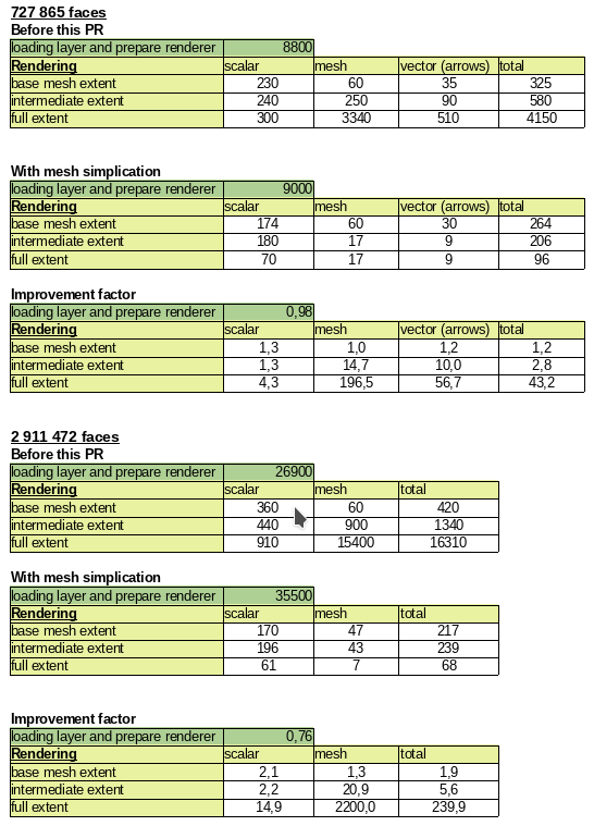
Демо GIF До: 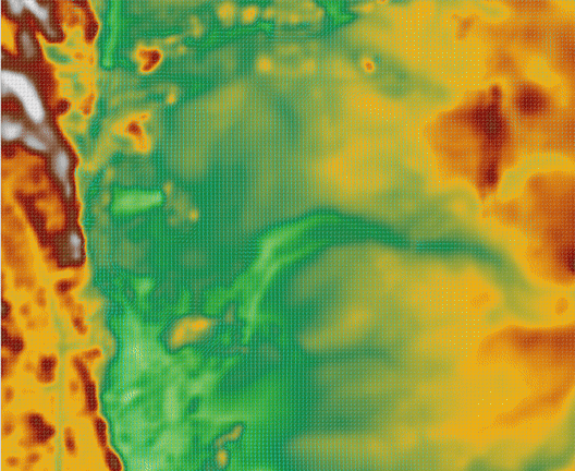
После: 
Спонсорская поддержка - BMT
Разработчик - Lutra Consulting (Vincent Cloarec)
3D функциональность
Feature: Arrows for 3D mesh layer dataset rendering
This feature adds an option for displaying arrows on a mesh layer dataset 3D entity, depending on vector dataset.
The dataset used to render arrows is the one chosen for rendering vectors on 2D rendering.
In the same way, the color of arrows are defined in the 2D rendering settings for vector dataset.
In 3D settings, the user can define the spacing of arrows and if size is fixed or scaled on magnitude.
This spacing setting also defines the maximum size of arrows because arrows can’t overlap. 
Разработчик - Lutra Consulting (Vincent Cloarec)
Print Layouts
Feature: Temporal settings for layout map items
This feature adds a collapsible section to the layout map item widget that allows users to enable and set a temporal range to be used when rendering map content.
The start and end datetime value can be data-defined, which comes in handy when used alongside atlas features.
Спонсорская поддержка - iMHere Asia
Разработчик - Mathieu Pellerin
Feature: Allow sorting attribute table by field not listed in the table
Instead of using the same data model for the displayed and the sorting columns, two data models are now used. They use the same API / base class as they are very similar.
Разработчик - Denis Rouzaud
Feature: Expose control over layer legend splitting behavior on a layer-by-layer basis
This allows users to manually override the legend’s default setting for «split layers» on a layer-by-layer basis, by double clicking a layer in the layout legend panel and choosing whether that layer:
Follows the default legend setting for splitting
Can ALWAYS be split over multiple columns (regardless of the legend’s setting)
или
Can NEVER be split over multiple columns (regardless of the legend’s setting)
Спонсорская поддержка - SLYR
Разработчик - Nyall Dawson
Feature: Allow customisation of division and subdivision symbols as distinct from scalebar tick horizontal symbol
Allows for styling division and subdivision symbols in a different way compared with the horizontal line symbol in a tick scalebar
Спонсорская поддержка - SLYR
Builds off the hard work done by @agiudiceandrea!
Разработчик - Nyall Dawson
Feature: Allow overriding the default symbol for a legend node
This allows users to (optionally) customise the symbol appearance for a legend node, e.g. to tweak the colors or symbol sizes to better provide a «representative» patch symbol compared with how those corresponding features actually appear on the map.
It’s useful for exaggerating symbol widths, or for manually tweaking the colors of semi-transparent symbols so that the colors represent the actual appearance of the symbols when rendered on top of the map content. Or to tweak the marker interval/offset in marker lines so that the markers are nicely spaced in the legend patch.
Разработчик - Nyall Dawson
Feature: Allow placing manual column breaks in legends
Adds the option when configuring a legend item to place a column break before the item, causing it to be placed into a new column.
This allows user control over the column content, for cases when the automatic column generation doesn’t result in the desired results.
Разработчик - Nyall Dawson
Feature: Add subdivisions in ticks scalebar right segments
Adds the ability to create subdivisions for segments included in the right part of the ticks scalebar.
Line Ticks Up 
Line Ticks Middle 
Line Ticks Down 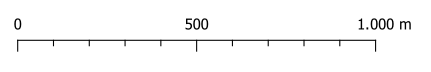
Scalebar item properties - Segments groupbox 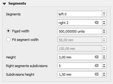
The behaviour related to the segments on the left side of the scalebar is unchanged.
Разработчик - Andrea Giudiceandrea
Feature: Allow overriding the legend patch size on a per-item basis
Allows users to override the symbol patch size for individual legend nodes, by double clicking the node
Width and height can be individually overridden, with the node falling back to the default width or height when the override isn’t set.
Спонсорская поддержка - SLYR 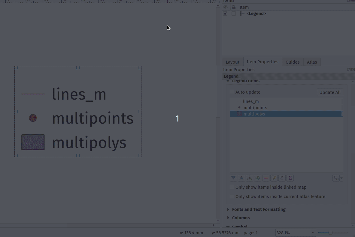
Разработчик - Nyall Dawson
Feature: Allow control over the horizontal spacing before legend group/subgroup/symbols
Gives flexibility to allow «nesting» legend groups/subgroups/symbols and much greater control over legend item placement.
Спонсорская поддержка - SLYR
Разработчик - Nyall Dawson
Feature: Manage legend patch shapes through style manager
This update finalises the recent legend patch shape customisation work, by adding in support for custom legend patch shapes to style manager!
Now we just need a really nice set of default patch shapes to ship!!
Разработчик - Nyall Dawson
Feature: Allow configuring legend patch shapes by double-clicking on legend items
Allows users to set custom legend patch shapes for items by entering a WKT string representing the patch geometry.
Спонсорская поддержка - SLYR
Разработчик - Nyall Dawson
Возможность вставки изображений непосредственно в макеты
Встраивание вставленной картинки в макет.
Разработчик - Nyall Dawson
Feature: Allow marker items to sync rotation with maps
This allows creation of north arrows from marker symbols, exposing the same options as exist for picture items acting as north arrows.
When a marker acts as a north arrow, the map rotation is ADDED to any existing marker symbol rotation (e.g. if you have to rotate the triangle marker 90% to get it pointing straight up, it will still work nicely in north arrow mode!)
Спонсорская поддержка - SLYR
Разработчик - Nyall Dawson
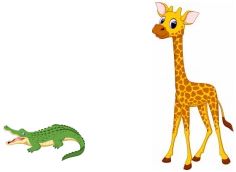
Feature: New item type for marker symbols
Allows marker symbols to be placed directly on layouts, e.g. for manually placing markers over a map item or for creation of advanced custom legends.
Previously you had to hack support for these, e.g. by drawing rectangles using centroid fill symbols. Much nicer to have a dedicated item type for it, allowing more specific customisation options (coming soon!)
Спонсорская поддержка - SLYR
Разработчик - Nyall Dawson
Feature: Add import content from clipboard for fixed table items
A new import content from clipboard feature has been added to QGIS“ table editor to enable quicker layout fixed table item editing and creation.
Спонсорская поддержка - iMHere Asia
Разработчик - Mathieu Pellerin
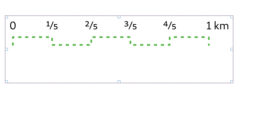
Feature: Add numeric formatter «fraction» style
This style represents decimal numbers as vulgar fractions, e.g. «3/4» instead of 0.75.
Options include using Unicode superscript and subscript characters for nicer typography, e.g. ¹⁷/₂₃ (this is the default mode, disabling this option uses the «17/23» format). An option also exists for using dedicated unicode characters for specific fractions (where a unicode character exists), e.g. ½ or ¾.
Ultimately this allows for creation of scalebars with fractional representations of distances, e.g. 0 —– ½ —– 1 km (instead of 0 —— 0.5 —— 1km)
Спонсорская поддержка - SLYR
Разработчик - Nyall Dawson
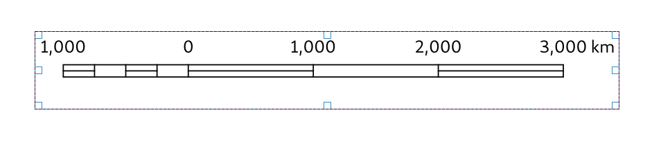
«Ступенчатая линия» и «Пустотелый» Стили масштабной линейки.
Добавляет два новых стиля масштабной линейки (которые доступны в ArcMap, но ранее было невозможно воспроизвести в QGIS)
Ступенчатая линия:
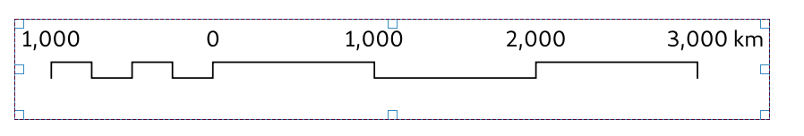
Пустотелый («Южно-Африканский») стиль:
Спонсорская поддержка - SLYR
Разработчик - Nyall Dawson
Feature: Allow scalebar line style to be set using standard QGIS line symbols
Instead of the previous settings of scalebar line color/width/cap styles, we now expose the option as a full line symbol for more advanced styling.
Код немного подчищен.
Спонсорская поддержка - SLYR
Разработчик - Nyall Dawson
Feature: Rework picture item UI and behavior
Adds an explicit choice between SVG or raster image sources, which allows us to clean up the configuration panel for layout pictures by hiding options which don’t apply to a certain picture source. Also permits us to:
Reuse the standard SVG selector tree widget, which loads images in a background thread
Uses the standard SVG and image selector line edit, which permits drag and drop of images and exposes options to embed images and link to online sources
Ultimately this is motivated by a desire to allow users to embed images in layouts and layout templates
Спонсорская поддержка - SLYR
Разработчик - Nyall Dawson
Управление Системой Координат через переменную
Это даёт возможность управлять Системой Координат Карты посредством переменной
Относится к #34547
Разработчик - Alex
Выражения
Новые выражения
asciimake_intervalAllows direct construction of interval values from years/months/weeks/days/hours/minutes/second values, without having to construct a string representation of the interval firstmaptiplayer_property('distance_units')display_expressioneval_templatemake_datemake_timemake_datetimeclose_lineis_multipartgeometry Z and M minimum and maximum
@frame_number@frame_rate@frame_duration@map_start_timeStart of the map’s temporal time range (as a datetime value)@map_end_timeEnd of the map’s temporal time range (as a datetime value)@map_interval:Duration of the map’s temporal time range (as an interval value)@animation_start_time@animation_end_time
Разработчики - Etienne Trimaille, Jan Caha, Julien Monticolo, Nyall Dawson
Feature: Feature browser for preview in expression builder
В конструктор выражений добавлен браузер объектов, чтобы можно было предварительно просматривать просматривать результат вычислений функции для конкретных объектов |Рисунок 65|
A new widget is added: QgsFeaturePickerWidget. For the moment, it’s a simple combobox (but inherits widget so we can add a map picker button later on). It behaves the same way than the one in the relation reference widget (an editable combobox).
It relies on the same base model (QgsFeatureFilterModel). A new abstract class QgsFeaturePickerModelBase regroups the logic of the, and the new model is called QgsFeaturePickerModel. Basically the QgsFeaturePickerModel used the feature id to identify the features while QgsFeatureFilterModel use a list of attributes (the foreign keys of a relation). It declutters a bit the former model which was quite…cluttered.
As a side note, I tried to use templates for QgsFeaturePickerModelBase, but since templates cannot be mixed with Q_OBJECT, the alternatives sounded like the code would be less readable.
Tests have been added.
Sponsored by the QGIS Swiss User Group!
Разработчик - Denis Rouzaud
Feature: Ability to remove custom functions
Adds a remove button to the Functions Editor tab in the Expression builder dialog to allow the removal of user functions from QGIS without needing to navigate to the user profile directory.
Разработчик - Alexander Bruy
Feature: Add ability to edit, import and export user expressions
A new button is added that allows editing of saved expressions. It is only active when a user expression is selected in the expressions tree. When pressed, it opens a window that allows the currently selected user expression to be edited. Changing the label of the expression makes a copy of the currently existing one. Demo
Import/Export
A new button with a menu is added, that allows the import/export of user expressions to/from a JSON file. Clicking on either of the menu entries opens a file selector dialog for the expressions JSON file source/destination. In the case of label conflicts, an additional dialog asks how to proceed - either to overwrite or to skip the current expression. Import/Export Demo
Разработчик - Ivan Ivanov
Оцифровка
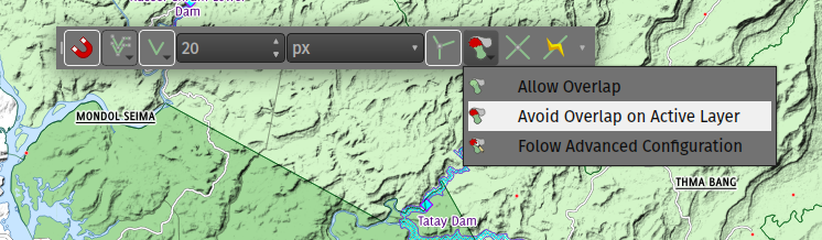
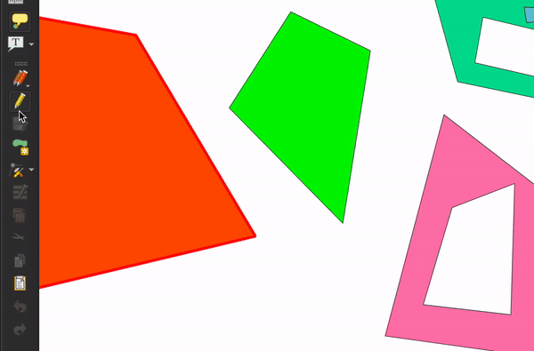
Feature: Dedicated avoid geometry intersection/overlap mode
This version of QGIS comes with a new dedicated avoid geometry intersection/overlap mode setting when digitizing features.
Allow intersections/overlaps
Avoid intersections/overlaps on active layer
Avoid intersections/overlaps on user-defined layers list.
The third mode’s layers list is setup by the user via the advanced snapping configuration widgets.
Спонсорская поддержка - OpenGIS.ch
Разработчик - Mathieu Pellerin
Feature: New snapping modes: Centroid and middle of a segment (midpoint)
Эта функция нацелена на улучшение режимов привязки в QGIS <https://github.com/qgis/QGIS-Enhancement-Proposals/issues/107>`__ путем приближения к опыту инструментов CAD.
It adds two new modes. Snapping on the center of a geometry (centroid) and the middle of a segment.
To allow the selection of these new modes, several snapping modes can be selected at the same time.
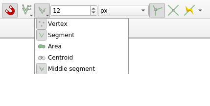
The order of preference for snapping is as follows: - Vertex, Intersection - Middle - Centroid - Edge - Area
Sponsored by: Qwat group / Ville de Lausanne ( @ponceta @dsavary ) / Oslandia and some spare time
Разработчик - lbartoletti
Feature: Snapping to the currently digitized feature
Snapping can now also supports snapping to the feature currently being digitised. This option is enabled/disabled a new button in the snapping toolbar.
This enables some really nice CAD-like editing abilities, such as closing features at a 90° angle or precisely aligning segments inside a feature. It’s very efficient once one is accustomed to using the alt+a shortcut to lock the angle.

Спонсорская поддержка - Кантон Золотурн и федеральная земля Форарльберг
Разработчик - Olivier Dalang
Feature: Tracing now supports curved geometries
The tracing tool now creates curved geometries when working on a layer that supports curved geometries.

The support is still experimental, so this feature must be enabled in the digitizing options.
Спонсорская поддержка - ecoptima и Planteam
Разработчик - Olivier Dalang (OPENGIS.ch)
Forms and Widgets
Feature: Allow editing of links in file widget
In a form, links can now be edited in the file widget (when the widget is not readonly).
Sponsored by the QGIS Swiss user group
Разработчик - Denis Rouzaud
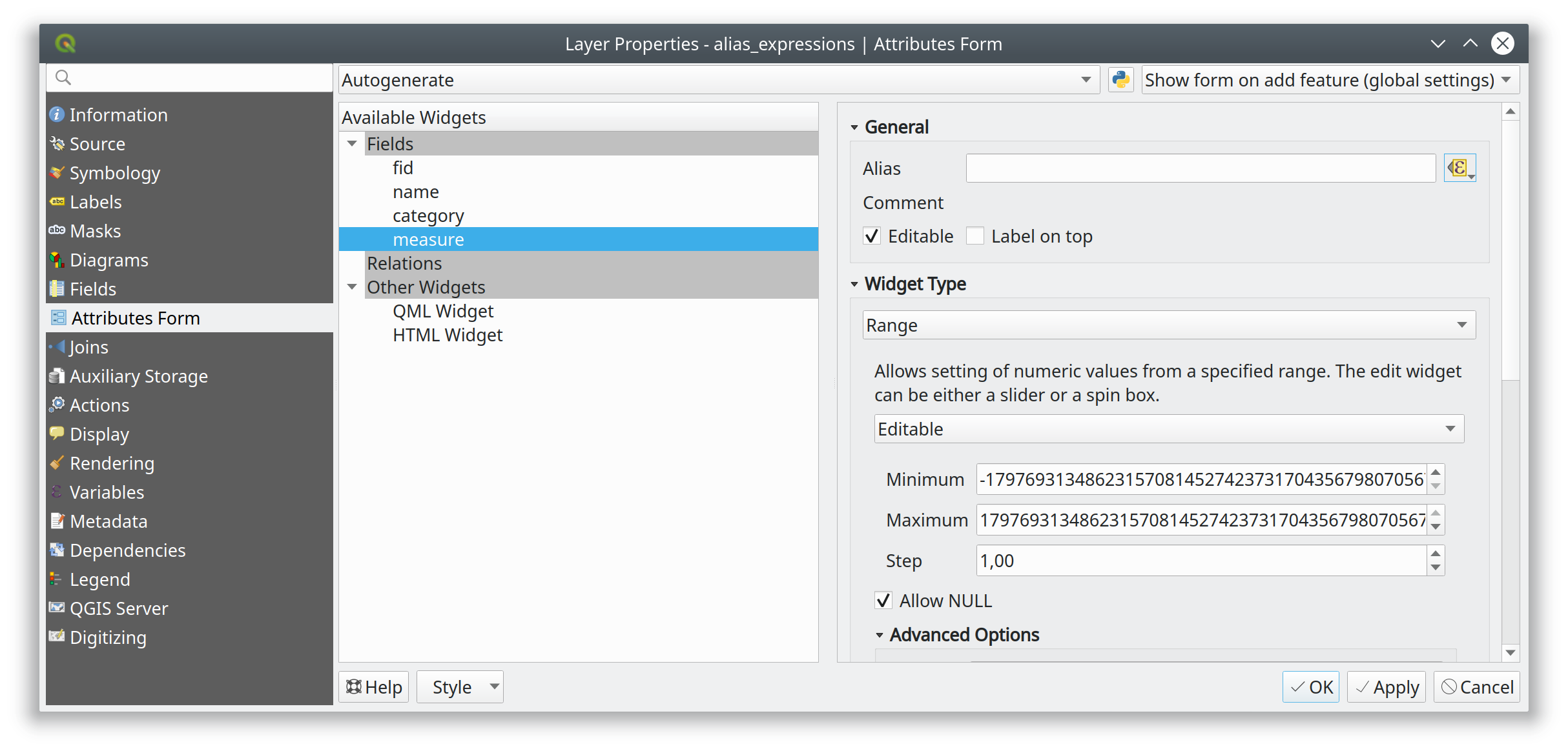
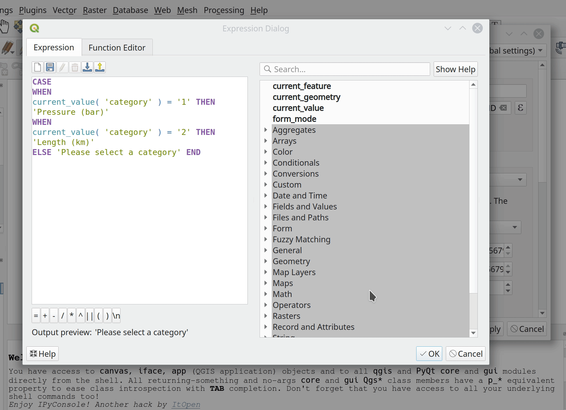
Feature: Expression controlled labels (aliases)
This new feature allows form labels (aliases) to be evaluated in the form context.
Спонсорская поддержка - A.R.P.A. Piemonte
Разработчик - Alessandro Pasotti
Feature: Add description to value relation widget
Adds an option for adding a description to each value in a value relation widget. The description will show up as tooltip
Please excuse the different languages in the demo video.
Разработчик - Matthias Kuhn
Feature: New database table name widget
A new widget was added to QGIS to select a new table from an existing DB connection:
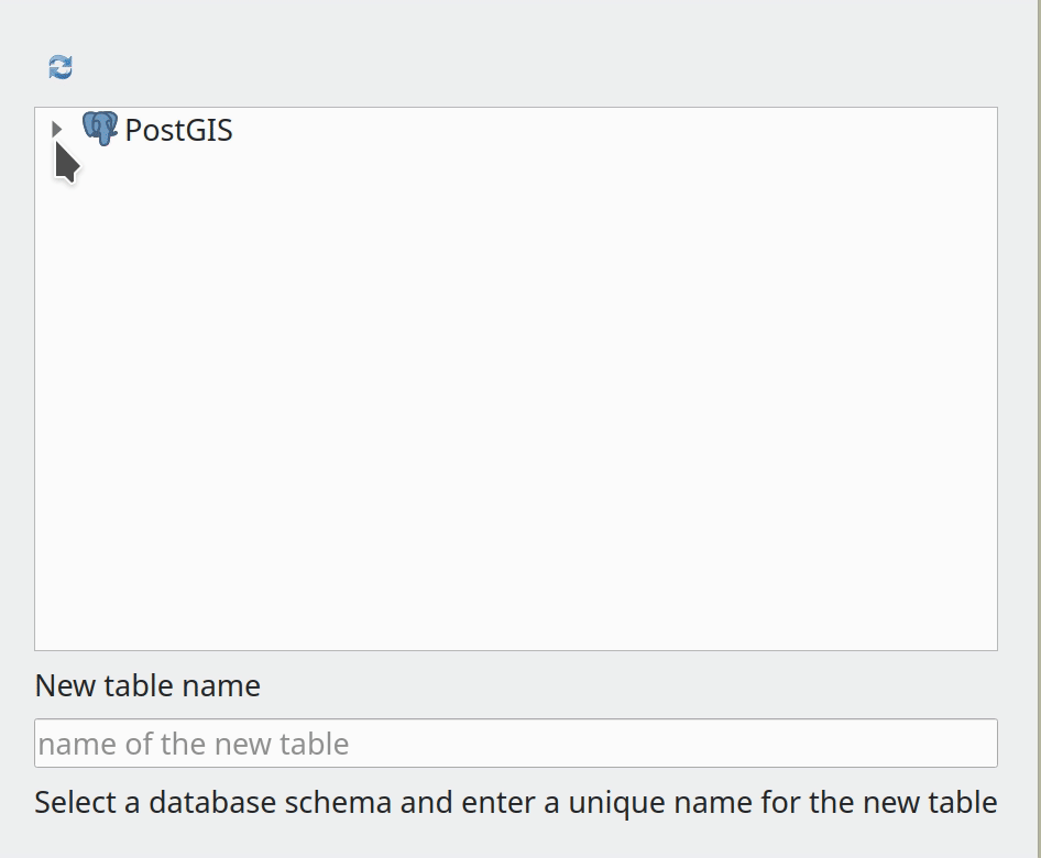
Разработчик - Alessandro Pasotti
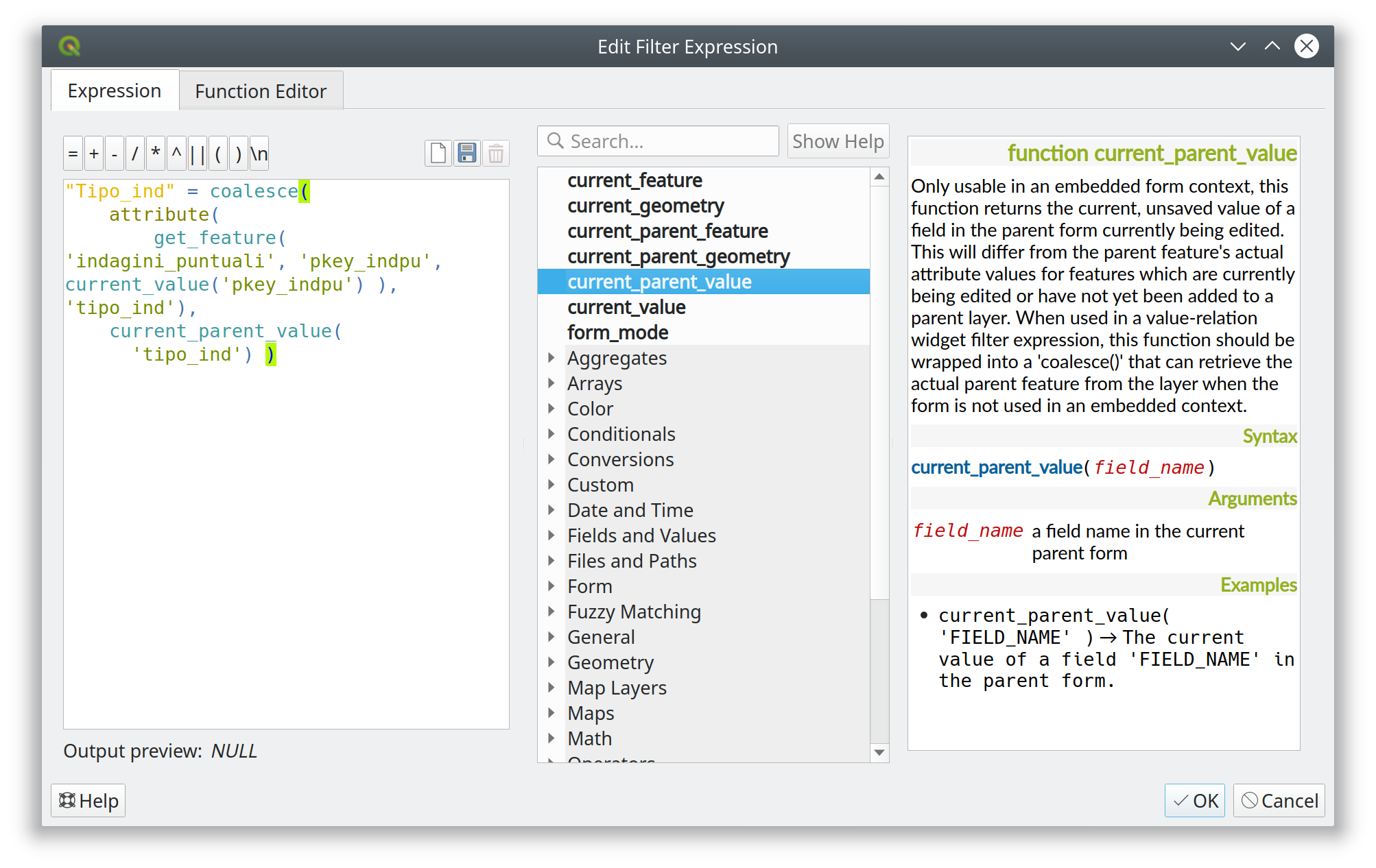
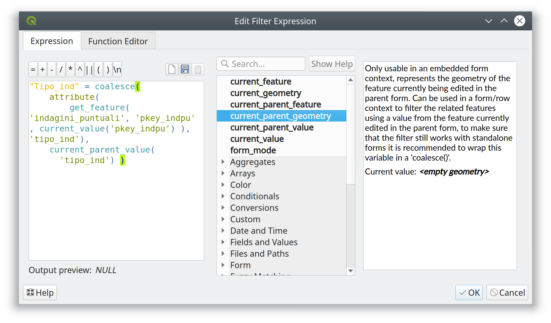
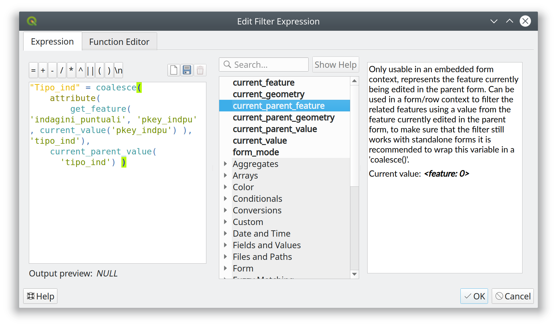
Feature: Get current parent form values in child forms
This feature adds the option of using current values from the «parent» form in filter expressions (for now only in value-relation widgets: to be used in drill-down filters).
A new «parentForm» scope was added as well as a new set of functions and variables to access the parent from within an embedded child form. The new functions and variables were modelled on the existing «current_value», «current_feature» etc.
The new functions and variables are also available when the parent form is opened from a new (unsaved, unbuffered) feature, making it easier to create drill-down filters based on the parent’s values when adding children from an unsaved parent form.
Example
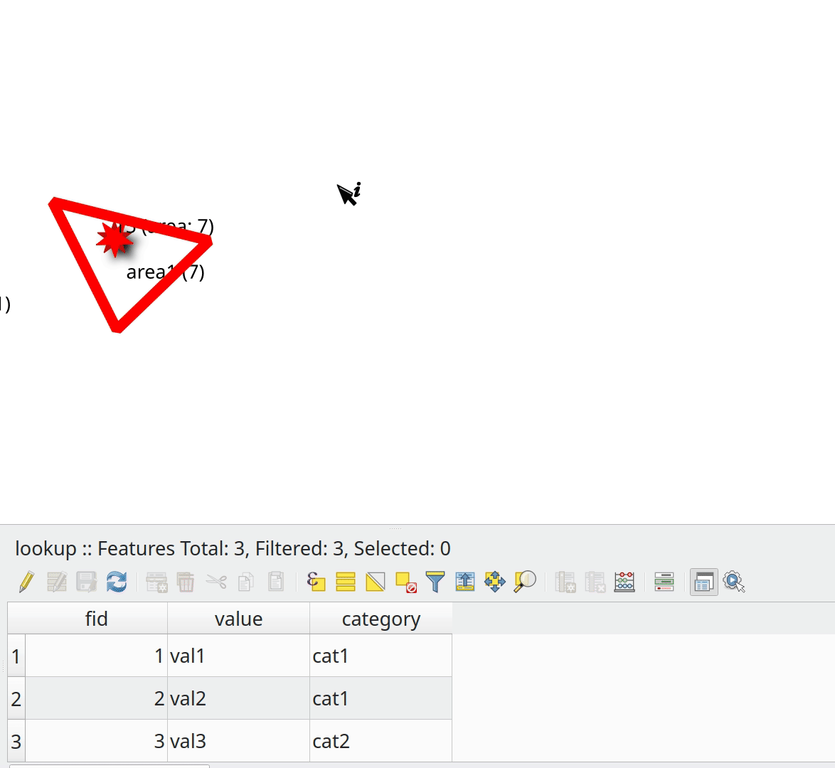
New functions and variables
Спонсорская поддержка - ARPA Piemonte
Спонсорская поддержка - A.R.P.A. Piemonte
Разработчик - Alessandro Pasotti
Feature: Relation widget: add checkbox to hide save child edits button
This is very useful for embedded forms.
Спонсорская поддержка - ARPA Piemonte
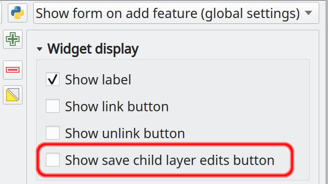
Спонсорская поддержка - A.R.P.A. Piemonte
Разработчик - Alessandro Pasotti
Feature: Relation widget force suppress popup
Adds an option to the relation widget configuration to suppress form popup open when new features are added in an embedded form context.
This option overrides the form-level option (that might still be the desired behavior when the form is used as a standalone form).
Note: the final label is Force hide form on add feature
Спонсорская поддержка - A.R.P.A. Piemonte
Разработчик - Alessandro Pasotti
Легенда слоя
Feature: Allow renaming of the current map theme
This adds the option of renaming a map theme from the map theme drop-down menu.
Разработчик - Harrissou Sant-anna
Инструменты анализа
Feature: Network logger - more functionality
Adds some more useful tools to the network logger:
Копировать URL
Copy request as JSON
Save log to file (after a big warning to users that the log may contain sensitive information and should be treated as confidential)
Разработчик - Nyall Dawson
Feature: Inbuilt network logging tool
This tool, which is available from the new F12 «dev tools» panel, is a native port of @rduivenvoorde’s network logger plugin.
It shows a list of ongoing and completed network requests, along with a whole load of useful detail like request and reply status, headers, errors, SSL configuration errors, timeouts, cache status, etc.
Also has loads of polish and useful capabilities, such as the ability to filter requests by URL substrings and status, and you can right-click requests to open the URL in a browser or copy them as a cURL command.
Why do we want this as a native tool instead of a plugin? Well:
It’s extremely useful, so is nice to have available out-of-the-box
By moving it to c++, we can startup the logging process much earlier than a plugin gets the opportunity to. This allows the log to include additional information, such as requests fired off by other plugins which occur before the network logger plugin has been loaded (also other in-built requests, e.g. news feed)
Performance has been an ongoing struggle with the Python plugin. While this is about as close as a 1:1 port as you can get, the performance issues have all been magically solved. The classes have some very intensive list operations, which is likely the cause of the poor performance under Python.
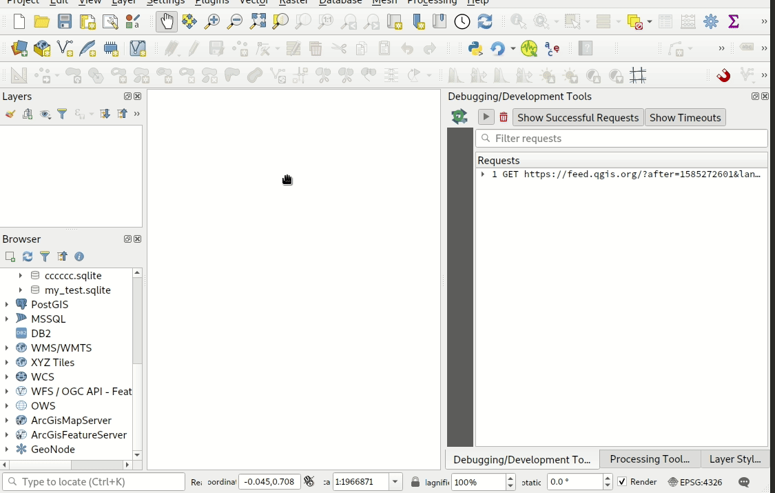
Спонсорская поддержка - Метеорологическая служба Канады
Разработчик - Nyall Dawson (for Kartoza)
Анализ
Feature: Collection of random raster generation algorithms
With this feature we added a large collection of random number raster generation algorithms. The algorithms are capable of outputting random rasters following specific random number distributions. The following distributions are available:
Создать случайный растровый слой (биномиальное распределение)
Создать случайный растровый слой (экспоненциальное распределение)
Создать случайный растровый слой (гамма распределение)
Создать случайный растровый слой (отрицательное биномиальное распределение)
Создать случайный растровый слой (нормальное распределение)
Создать случайный растровый слой (распределение Пуассона)
Создать случайный растровый слой (равномерное распределение)
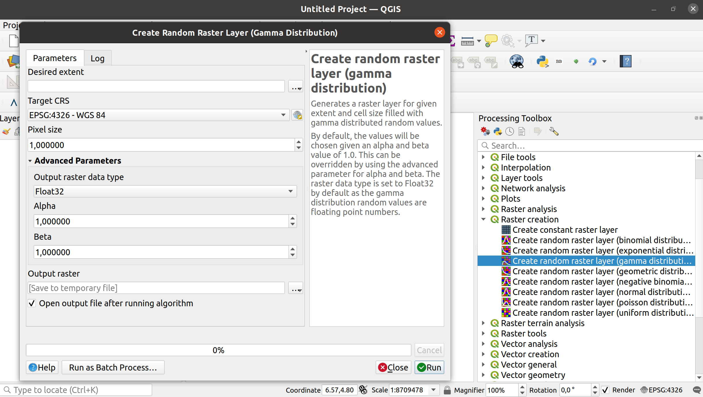
Разработчик - Clemens Raffler
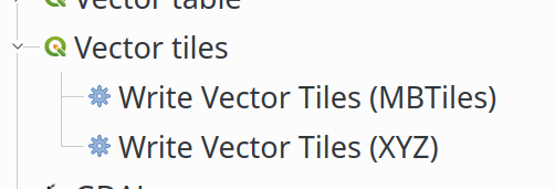
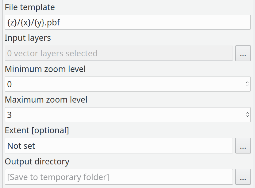
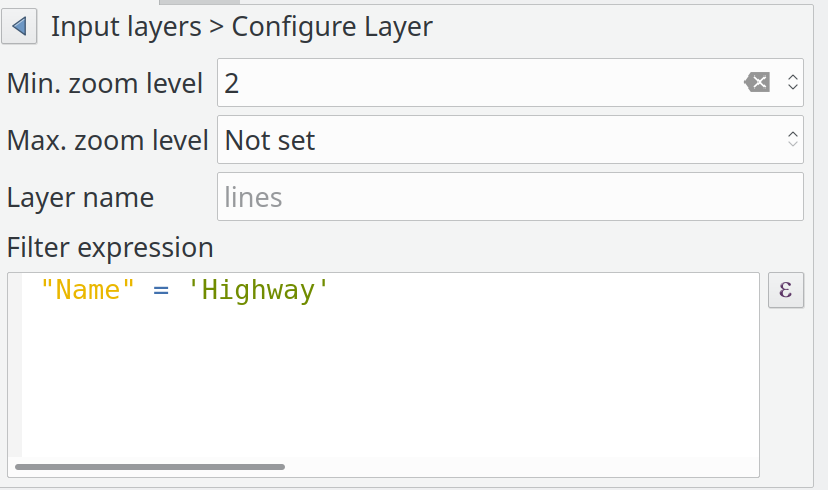
Feature: Vector tile layer - part 8 (writer in Processing)
This feature adds Processing integration for vector tile writing. It is just a wrapper around the existing QgsVectorTileWriter class.
New algorithms in the Processing toolbox:
Algorithm’s parameters for XYZ:
Algorithm’s parameters for MBTiles:
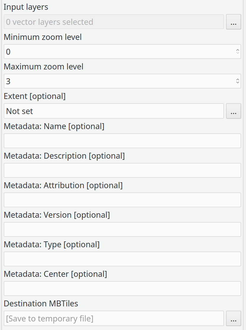
List of input layers:
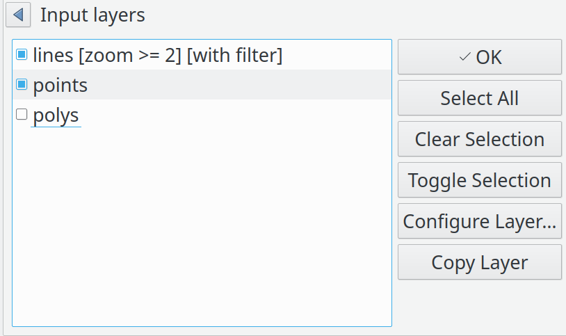
Input layer details:
Спонсорская поддержка - Сообщество QGIS
Разработчик - Lutra Consulting (Martin Dobias)
Feature: New modeler algorithm for creating conditional branches
This algorithm allows users to setup multiple conditions (via qgis expressions), which cause their corresponding branch of the model to be run or skipped depending on the result of the expression evaluation.
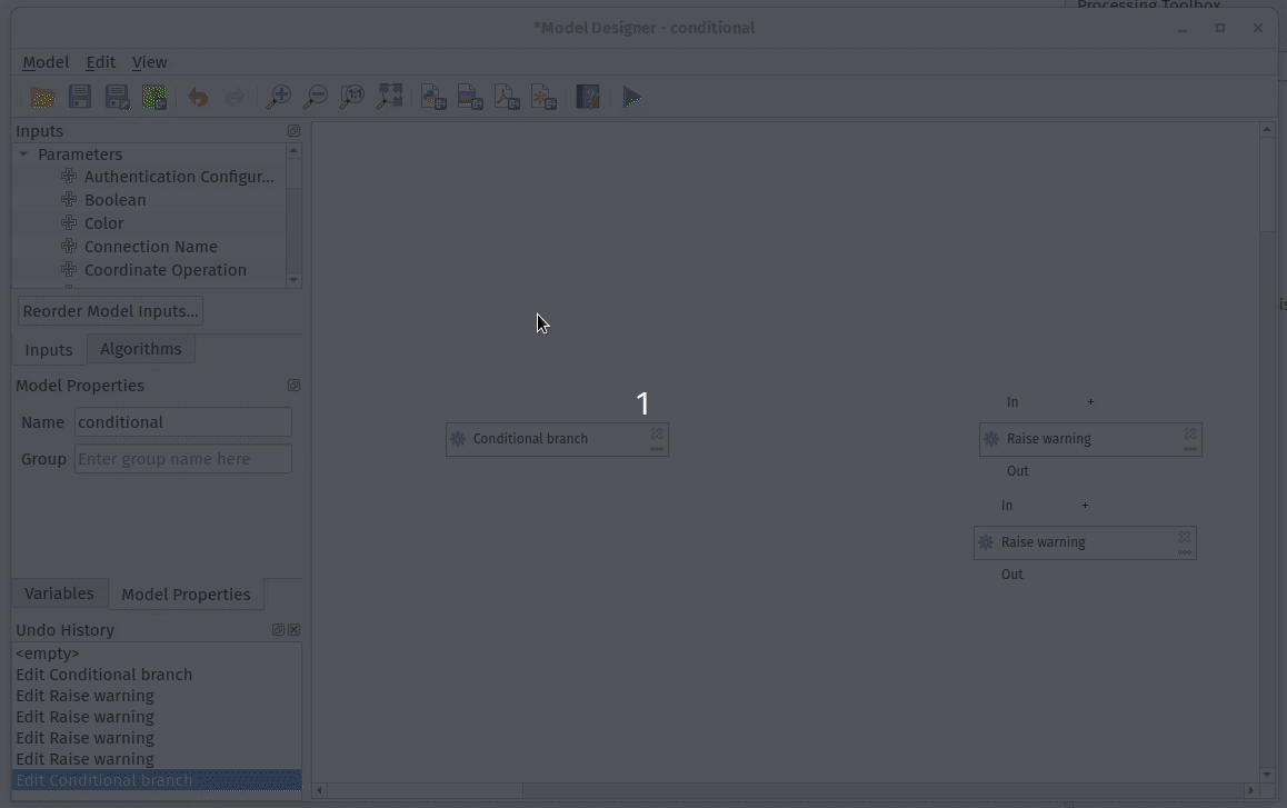
Спонсорская поддержка - Andreas Neumann
Разработчик - Nyall Dawson
Feature: Allow reordering model inputs
Instead of forcing a quasi-random ordering of inputs for models, this feature exposes a new «Reorder Model Inputs» option in the model designer which allows users control over the exact order of inputs to show users for their model.
No more illogical ordering like showing a field choice before the layer choice it’s based on!
Sponsored by NaturalGIS
Разработчик - Nyall Dawson
Feature: Defer model validation
Instead of forcing all child algorithms to be immediately valid and have all parameters correctly filled, this feature defers model validation until run time or when a new «Validate model» action is triggered.
A common frustration with the QGIS model designer is that it constantly forces models to be valid, even work-in-progress models. This means it’s impossible to add a component to a model and only partially populate its settings — you have to fill in everything upfront. If you realise mid way through this that you need to make a change somewhere else in your model, it’s impossible to do without canceling and losing all the settings you’ve already configured.
This change sees the model validation deferred until run time. Models can be temporarily invalid (e.g. having algorithm components which are only partially configured). The missing required values can now be filled at a later stage, without losing any existing settings. If a non-valid model is run, the user gets a descriptive warning informing them of the changes they need to make in order to finish configuration of the model.
Разработчик - Nyall Dawson
Feature: Added support for different raster data types in Create constant raster layer algorithm
With this feature we added a new advanced OUTPUT_TYPE parameter for the Create constant raster layer algorithm. Via this parameter, you can now specify an output data type for your constant raster layers.
Byte
Integer16
Unsigned Integer16
Integer32
Unsigned Integer32
Float32
Float64
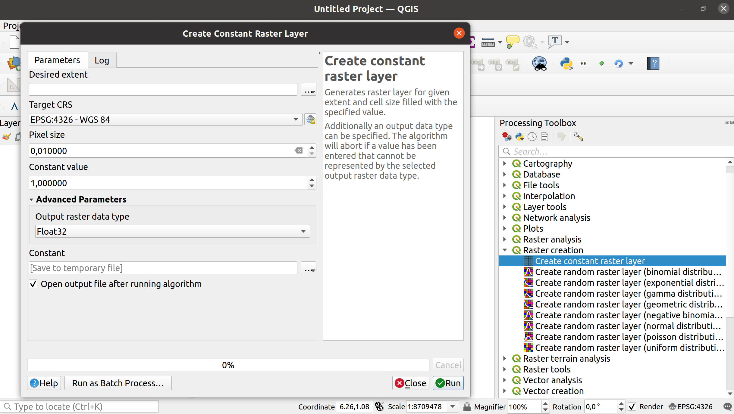
Разработчик - Clemens Raffler
Feature: Added Round raster algorithm
With this new processing algorithm we enable QGIS to round Raster values.
The main functionality of the algorithm is either standard up/nearest/down-rounding of floating point cell values or rounding to powers of a user specified base n. The algorithm can be used with rasters of all types (even byte/integer rasters when rounding to powers of n) and outputs the same raster data type. A standard floating point rounding of an integer raster will copy it and raise a warning.
The example shows an output raster rounded to multiples of 10
Разработчик - Clemens Raffler
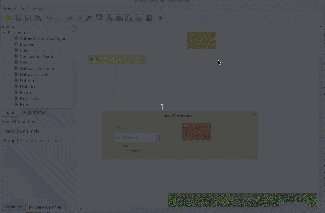
Feature: Allow copying/cut/paste of model components
This feature allows users to copy and paste model components, both within the same model and between different models
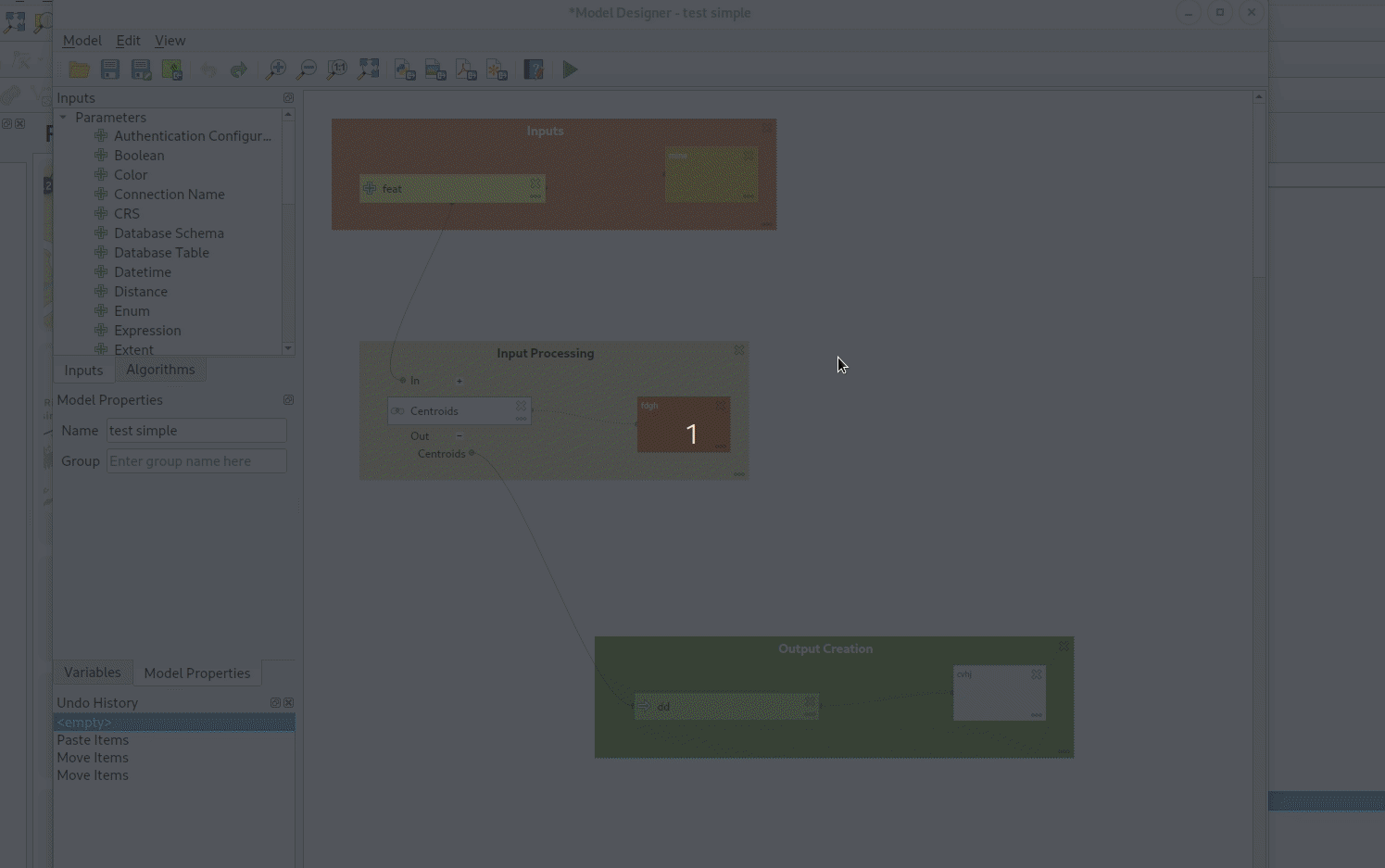
Refs NRCan Contract#3000707093
Разработчик - Nyall Dawson
Feature: Allow appending processing results to existing layers
When appending results, users are given a field mapping panel choice to allow them to manually set how fields are mapped to the destination layer’s fields:
Refs NRCan Contract#3000707093
Разработчик - Nyall Dawson
Feature: Allow creation of group boxes in models
Adds the following functions to the model designer:
The ability to customise the color of individual comments in a model
Allow creation of «Group Boxes» in models, which are a visual indicator of logically linked model components (e.g. „Data Preparation Steps“, „NDVI Calculation Steps“, … etc). Users can customise the color and title for group boxes.
Allow navigation direct to group boxes from the View menu, aiding navigation of complex models.
Refs NRCan Contract#3000707093
Разработчик - Nyall Dawson
Feature: Processing: show input and output values for children after running model through designer
A picture explains this best! After running the algorithm through the designer, you now see the values calculated for the inputs and outputs for each child algorithm:
This is very useful for debugging models – you can see a much clearer visual picture of the flow of values through the model.
Refs NRCan Contract#3000707093
Разработчик - Nyall Dawson
Feature: Add «Save Log to File» algorithm for models
This algorithm saves the contents of the execution log (right up to the point in the model at which the „save log“ algorithm executes) to a file.
It can be used to automatically store the debugging log when running models for later reference and transparency.
Refs NRCan Contract#3000707093
Разработчик - Nyall Dawson
Feature: Allow running algorithms directly on database (and other non-disk) sources without loading into projects first
This change allows users to directly browse to non disk-based layer sources for any processing feature source inputs. It allows these inputs to be taken direct from postgres, sql server, oracle, wfs, afs, etc layers directly without having to first load them into a project!
We take full advantage of the QGIS browser to enable this:
Refs NRCan Contract#3000707093
Разработчик - Nyall Dawson
Feature: Expose per-feature-source advanced options for processing inputs
This feature exposes per-feature-source advanced options, such as:
The ability to limit the number of features read from the source. (Useful in model development, you can easily test run models using a small subset of an input layer)
The ability to override on a per-input basis the global processing option for how to handle invalid geometries. Now you can safely leave the default processing setting at the conservative «Stop algorithm execution when a geometry is invalid» setting while easily temporarily overriding this for one particular input!
Refs NRCan Contract#3000707093
Разработчик - Nyall Dawson
Feature: Enable snapping to grid for models in designer
This update implements two «snapping» features in the Processing model designer:
Users can enable a new «Enable Snapping» option from the view menu, which will cause all component moving or resizing operations to automatically snap to grids
After selecting some components, users can select Edit -> Snap Selected Components to Grid to manually snap just those selected components.
Additionally, I’ve added a helpful «select all» action for quickly selecting all components in a model.
Refs NRCan Contract#3000707093
Разработчик - Nyall Dawson
Feature: Add «filter by geometry type» and «filter by layer type» algorithms to processing
This update adds two new algorithms to processing:
«Filter by geometry type»: This algorithm filters features by their geometry type. Incoming features will be directed to different outputs based on whether they have a point, line or polygon geometry. It allows for model creation which responds to different input layer geometry types by applying different logic depending on the input geometry type.
«Filter by layer type»: This algorithm allows conditional model branching based on an input layer type. For instance, it allows a model to adapt to the actual layer type of a generic «map layer» parameter input, and decide which branch of the model to run as a result.
It also adds in the required API to allow algorithms to «prune» model branches based on their calculated results. For example, a model which returns the new FlagPruneModelBranchesBasedOnAlgorithmResults flag will cause any remaining parts of the model which are dependent on the outputs of that algorithm to be entirely skipped IF the algorithm does not return that particular output. (This is a prerequisite component for a future generic «conditional branching by expression» algorithm, and also used by «filter by layer type» to control the model flow based on the input layer type)
Refs NRCan Contract#3000707093
Разработчик - Nyall Dawson
Feature: «Remove Null Geometries» algorithm can also remove EMPTY geometries
Empty geometries do not contain coordinates. Thus, like null geometries, empty geometries are not spatial data in a strict sense. To make it easier for users to clean a vector layer, the Remove Null Gometries algorithm now has an «Also remove empty geometries» option.
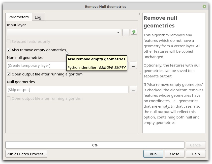
Спонсорская поддержка - SwissTierras Colombia
Разработчик - Germán Carrillo
Feature: Add multi-selection handling to model designer, interactive resizing
Adds:
The ability to select multiple items at once in the model designer
The ability to resize individual or multiple items
The ability to delete multiple selected items
Improved model designer «tool» interaction, following the layout designer approach (e.g. alt + space = zoom drag mode, and selection tools follow their counterparts in layouts so shift+selection adds to selection, ctrl+selection removes, etc)
Selected items can be moved by the cursor keys
Refs NRCan Contract#3000707093
Here’s how it looks in action (with a particular ugly looking test model I use!)
Разработчик - Nyall Dawson
Feature: Add undo/redo support to model designer
Makes QGIS more forgiving for users!
Refs NRCan Contract#3000707093
Works just like you’d expect:
Note that we save the whole model definition in the undo stack, not just the affected component changes.
Разработчик - Nyall Dawson
Feature: Remember parameter values between model designer runs
When designing a model, users typically will need to run the model many times as they tweak its structure.
This change causes the parameters used when running the model from the designer to be remembered and saved into the model, so that each time you run the model from the designer you don’t have to re-set all the input parameter values to the desired test ones.
Makes iterative model design SO much easier!
Sponsored by Alta Ehf
Also includes a partial port of the model designer dialog from Python to c++, because c++ >> Python.
Разработчик - Nyall Dawson
Feature: Comments in Processing Models
This allows users to create comments attached to model components (inputs, algorithms or outputs). Comments are shown linked to the associated component, and can be freely moved around the model.
Спонсорская поддержка - Fisel + König
Разработчик - Nyall Dawson
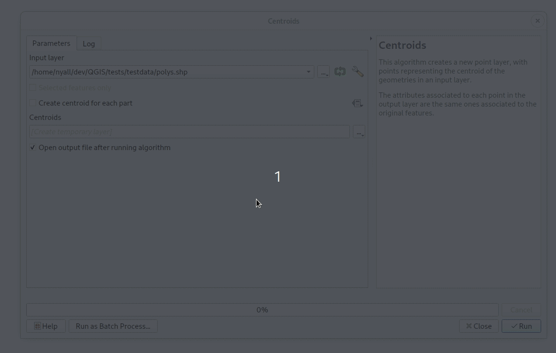
Feature: New standalone console tool for running processing algorithms
This new qgis_process tool allows users to run processing algorithms (both built-in, and those provided by plugins) directly from the console.
Running:
qgis_process listwill output a complete list of all available algorithms, grouped by provider.qgis_process pluginslists available and activated plugins which advertise the hasProcessingProvider metadata option (only these plugins are loaded by the tool)qgis_process help algidoutputs the help and input descriptions for the specified algorithm, e.g.qgis_process help native:centroids
qgis_process run: runs an algorithm. Parameters are specified by a --param=value syntax. E.g.
qgis_process run native:centroids --INPUT="my_shapefile.shp" --OUTPUT="centroids.kml"
или
qgis_process run native:buffer --INPUT=/home/me/my.shp --DISTANCE=20 --OUTPUT=/home/me/buffered.shp
While running an algorithm a text-based feedback bar is shown, and the operation can be cancelled via CTRL+C
Sponsored by the Swedish User Group
Разработчик - Nyall Dawson
Feature: New parameter type for datetime (or date, or time) values
Adds a new parameter type QgsProcessingParameterDateTime for handling date/datetime/time values.
Разработчик - Nyall Dawson
Feature: Add algorithms for raising warnings and exceptions from models
These algorithms raise either a custom warning in the processing log OR raise an exception which causes the model execution to terminate.
An optional condition expression can be specified to control whether or not the warning/exception is raised, allowing logic like «if the output layer from another algorithm contains more than 10 features, then abort the model execution».
Sponsored by Fisel + König
Разработчик - Nyall Dawson
Feature: Add Fill NoData cells algorithm
In the new QGIS version we introduce a new processing algorithm for filling NoData cells in a raster dataset with a constant numerical input.
The algorithm scans an input raster dataset for NoData cells and fills them with the user defined fill value. Doing so, the algorithm respects the data type of the input raster so that e.g. floating point numbers will be dealt with appropriately for an integer raster. The resulting dataset will not contain any NoData cells.
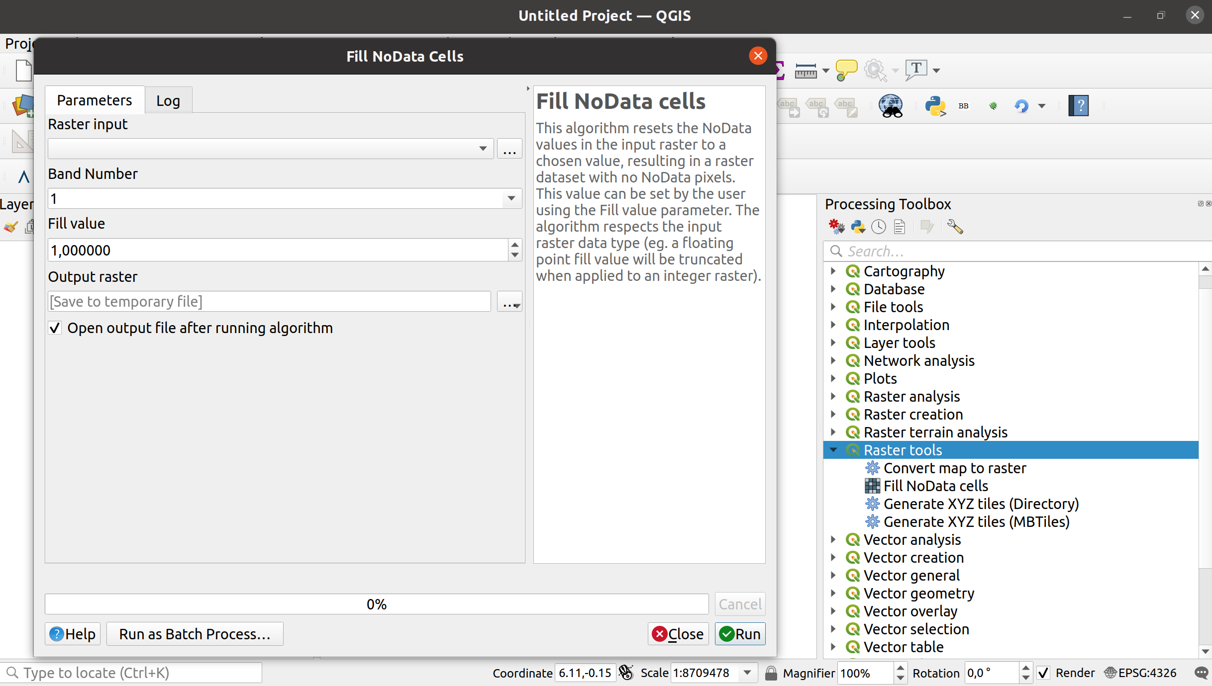
Разработчик - Clemens Raffler
Различные исправления в Инструментах Анализа
Finalize work on range parameters support in GRASS algorithms;
Исправлен неработающий алгоритм r.series
Небольшие исправления в алгоритмах r.rescale и r.rescale.eq
Исправление Инструмента Растеризации
GRASS GIS tests cleanup
Разработчик - Alexander Bruy
Feature: Show «template layer» field constraints in the «Refactor Fields» algorithm interface
When you are migrating data, it is important to be aware of constraints on target (a.k.a. template) layers.
The «Refactor Fields» algorithm now highlights constraints, and even lets you know more about them via tool-tips.
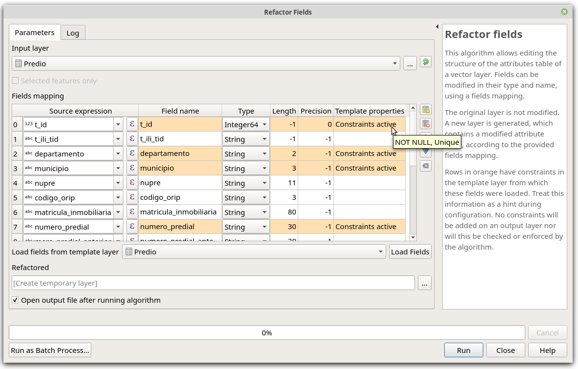
Спонсорская поддержка - SwissTierras Colombia
Разработчик - Germán Carrillo
Feature: New convert to curves algorithm
We added a new algorithm to convert segmentized geometries to curved geometries.
The algorithm considers successive points to represent a curve if they are evenly spaced and within a tolerance.
Разработчик - Nyall Dawson
Настройки приложения и проекта
Feature: Add @layers, @layer_ids project scope variables
Add @layers, @layer_ids project scope variables which contain lists of map layers and map layers ids for all layers from the current project
This mimics the existing @map_layers, @map_layer_ids, but unlike the @map variants these return ALL project layers, not just those associated with the current context’s map settings.
Спонсорская поддержка - SLYR
Разработчик - Nyall Dawson
Провайдеры данных
Feature: Allow adding attributes in the New Scratch Layer dialog
Позволяет пользователю добавлять атрибуты непосредственно в диалог Нового временного слоя, делая его более совместимым с другими диалогами, такими как Новый Shapefile / Geopackage. 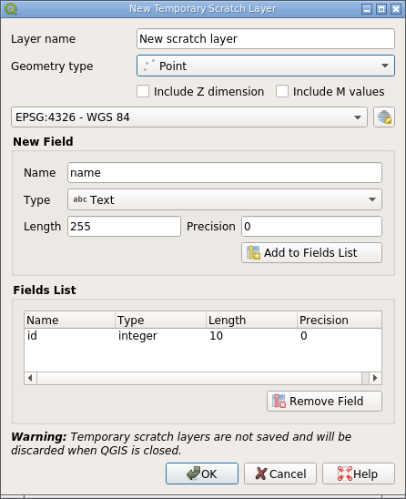
It is still possible to create a scratch layer without any attributes by not adding any fields to the list.
Разработчик - Alexander Bruy
Feature: Allow creating geometryless DBF tables from the New Shapefile dialog
Allow creating «plain» DBF files without associated geometries from the New Shapefile dialog.
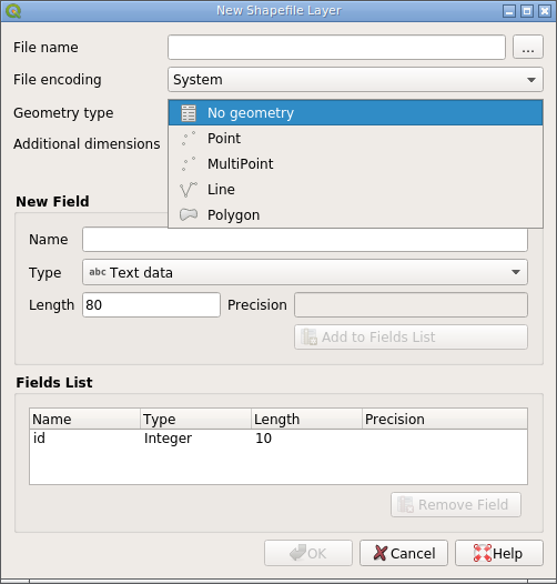
Creating DBF tables can be useful in some cases and having to use third-party tools for this instead of doing it from within QGIS is inconvenient. This also makes the New Shapefile dialog more consistent with the New Geopackage dialog, which already allows «geometryless» tables to be created.
Разработчик - Alexander Bruy
Feature: Allow filtering WM(T)S list in source dialog
Add ability to filter between lists of WMS or WMTS from the source dialog
WMS 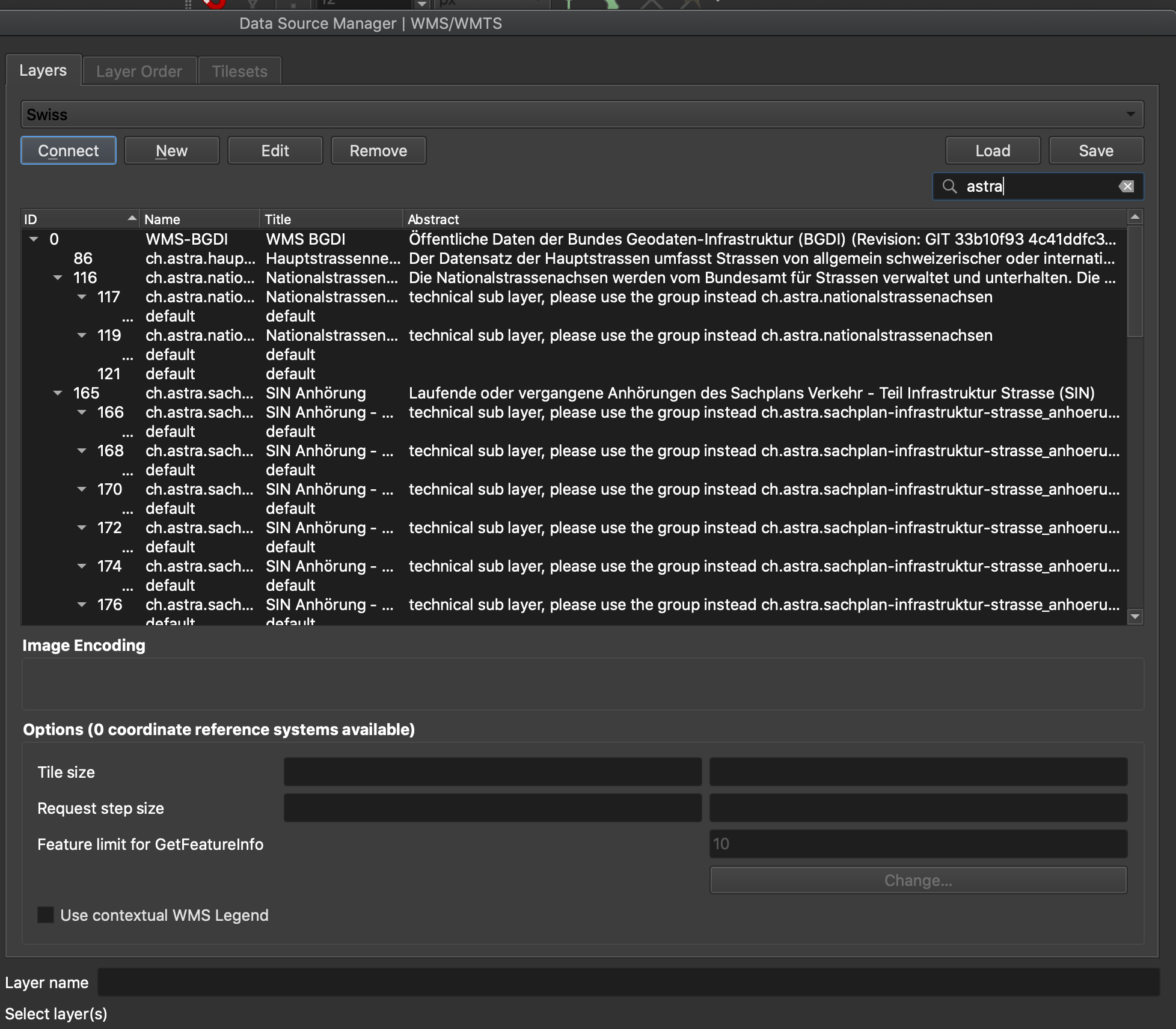
WMTS 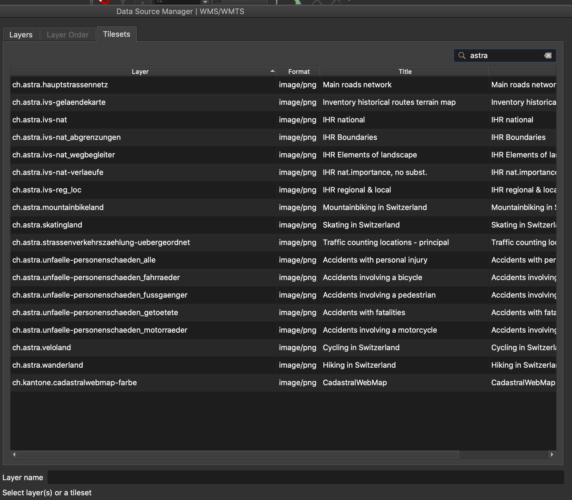
Sponsored by the QGIS Swiss user group
Разработчик - Denis Rouzaud
Feature: Import/export for ArcGIS Map and FeatureServer connections
Add missed import/export functionality for ArcGIS MapServer and FeatureServer connections.
Разработчик - Alexander Bruy
Feature: Spatialite transaction group
Transactions implementation for the native SpatiaLite provider.
Спонсорская поддержка - A.R.P.A. Piemonte
Разработчик - Alessandro Pasotti
Feature: Allowing saving outputs direct to more database formats (and other nice stuff)
This update allows users to save processing vector outputs directly to more database formats.
Previously outputs could only be written directly to postgres databases. With this change, this functionality has been made more flexible and now supports direct writing to any database provider which implements the connections API (currently postgres, geopackage, spatialite and sql server)
Ultimately this exposes the new ability to directly save outputs to SQL Server or Spatialite databases (alongside the previous GPKG+Postgres options which already existed)
(As soon as oracle, db2, … have the connections API implemented we’ll instantly gain direct write support for those too!)
We do this via a nice inline version of the new «new database table name» widget.
Other nice stuff includes:
You can now drag and drop file or folders from explorer or the qgis browser to output parameters in order to easily overwrite these files (or save to the folder), matching the behavior possible with inputs
You can actually write scripts which output direct to ANY qgis data provider (including oracle and db2)… it’s just that these don’t get exposed in the UI because they don’t yet support the connections API
Refs NRCan Contract#3000707093
Разработчик - Nyall Dawson
Feature: Add dedicated parameter type for database connections
Allows selection from the registered database connections for a specific database provider type (the provider must implement the connections API).
Refs NRCan Contract#3000707093
Разработчик - Nyall Dawson
Feature: PG: expose foreign tables
Expose foreign tables to the browser and data source select dialog.
Разработчик - Alessandro Pasotti
Feature: PG raster expose set filter to app
This should be the final change to the PG raster data provider and exposes the set filter options:
Filter can be set in the data source dialog (as for vector layers)
Filter can be set from the legend tree’s context menu (as for vector layers)
The renderer, the extent and the min/max stats are also updated when the filter changes
New tests for the new behavior
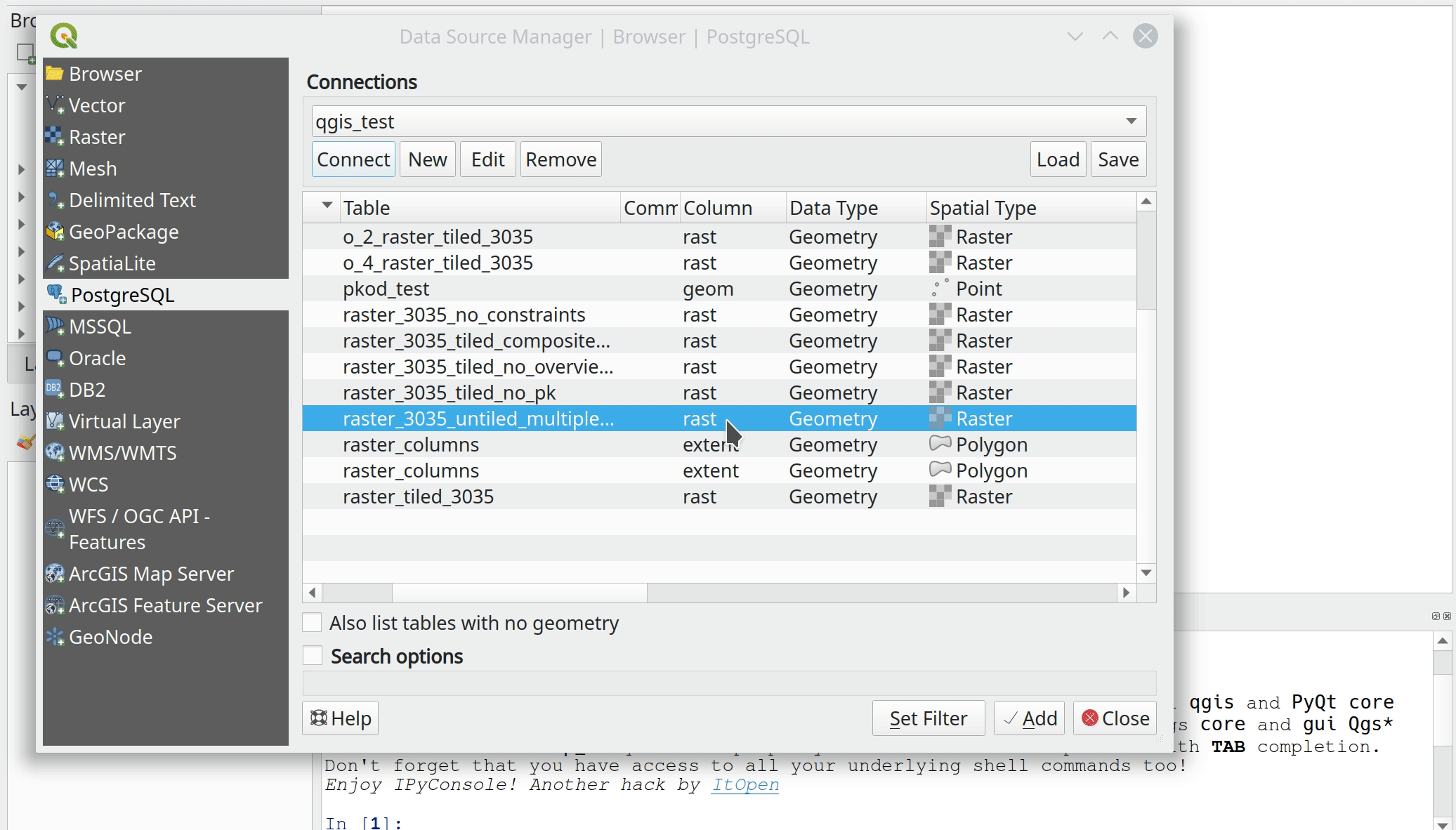
Спонсорская поддержка - A.R.P.A. Piemonte
Разработчик - Alessandro Pasotti
Feature: Postgres: save features into tables with generated fields
Allow updating/inserting features in PostgreSQL tables with generated fields. GENERATED columns is a feature introduced by PostgreSQL 12, which allows column values to be generated from other columns in the same table; this replaces the creation of triggers to, for instance, automatically populate and keep up-to-date a column of centroids or areas for the polygons in the main geometry column.
Разработчик - José de Paula Rodrigues N. Assis
Feature: Date and DateTime field types support added to Spatialite and Delimited Text providers
The Spatialite and Delimited Text providers now support Date and DateTime field types.
Разработчик - Mathieu Pellerin
QGIS Сервер
Feature: Add QGIS_SERVER_IGNORE_BAD_LAYERS config option
Allows the overriding of the default behavior in the case of bad layers (which is to invalidate the whole project).
When set to TRUE, bad layers are skipped and the remainder of the project becomes available.
Спонсорская поддержка - Geoinformatikbüro Dassau GmbH
Разработчик - Alessandro Pasotti
Feature: Server project settings, add „expanded“ attribute
In addition to the „visible“ and „mutuallyExclusive“ attribute, this update adds „expanded“ to the GetProjectSettings response of the server. The update allows a web client to see which layer tree elements are expanded / collapsed and to then present them the same way in the web map layer list.
Разработчик - mhugent
Feature: Add DXF server export params NO_MTEXT and FORCE_2D
QGIS server now supports the new parameters NO_MTEXT and FORCE_2D to control text and line symbology for generated DXF files.
Adds missing parameters to GetDxf request.
Разработчик - Matthias Kuhn
Feature: WMS project validator
The QGIS Server validator has been reviewed. This tool is useful when you want to publish a QGIS project using the WMS protocol.
For programmers, the validator is also now callable from PyQGIS, so plugins can now use it too.
Спонсорская поддержка - 3Liz
Разработчик - Etienne Trimaille
Feature: Webp
WebP - это современный формат изображений, который обеспечивает превосходное сжатие без потерь и с потерями для изображений в Интернете. WebP создает меньшие по размеру файла изображения, которые делают Интернет быстрее.
Размеры изображений без потерь в WebP на 26% меньше по сравнению с PNG. Изображения с потерями в WebP на 25-34% меньше, чем сопоставимые изображения JPEG с эквивалентным индексом качества SSIM.
Source: https://developers.google.com/speed/webp
With webp QGIS server now supports a format that provides smaller file sizes for the same quality and even provides transparency.
Спонсорская поддержка - OPENGIS.ch
Разработчик - Matthias Kuhn (OPENGIS.ch)
Модули
Feature: Allow plugins to register custom «Project Open» handlers
These allow plugins to extend the «Open Project» dialog by adding in support for new file filters, which appear in the formats drop down list alongside the existing «QGS Projects» entry.
Custom project open handlers then get first chance at loading project files.
This allows plugins to extend QGIS support by adding integrated support for opening projects from non QGS/QGZ formats, e.g. allowing users to open ArcGIS MXD documents or MapInfo WOR Workspaces direct from the project open dialog.
These non-native projects are also added to the recent projects list and welcome screen, giving them a truly first-class experience within QGIS.
Спонсорская поддержка - SLYR
Разработчик - Nyall Dawson
Feature: Allow users to install stable or experimental plugins
This update improves the plugin manager by allowing users to choose between installing the stable or the experimental version of a plugin.
This makes it possible to have pre-releases of plugins in the repository for power-users to test, while still allowing them to switch back easily to stable versions, without having to untick the global enable experimental option.
This change makes no difference for users who haven’t checked the enable experimental option.
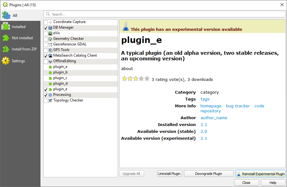
Спонсорская поддержка - Швейцарской группой пользователей
Разработчик - Olivier Dalang
API и изменения для разработчиков
Feature: Support for adding dock widgets as tabs: addTabifyDockWidget()
Dock widgets are great for displaying complex interfaces that extend QGIS functionality.
Now, both core and plugin devs have the option to tabify their dock widgets on top of existing ones. They can even choose on top of which dock widget they want their own dock widget appear.
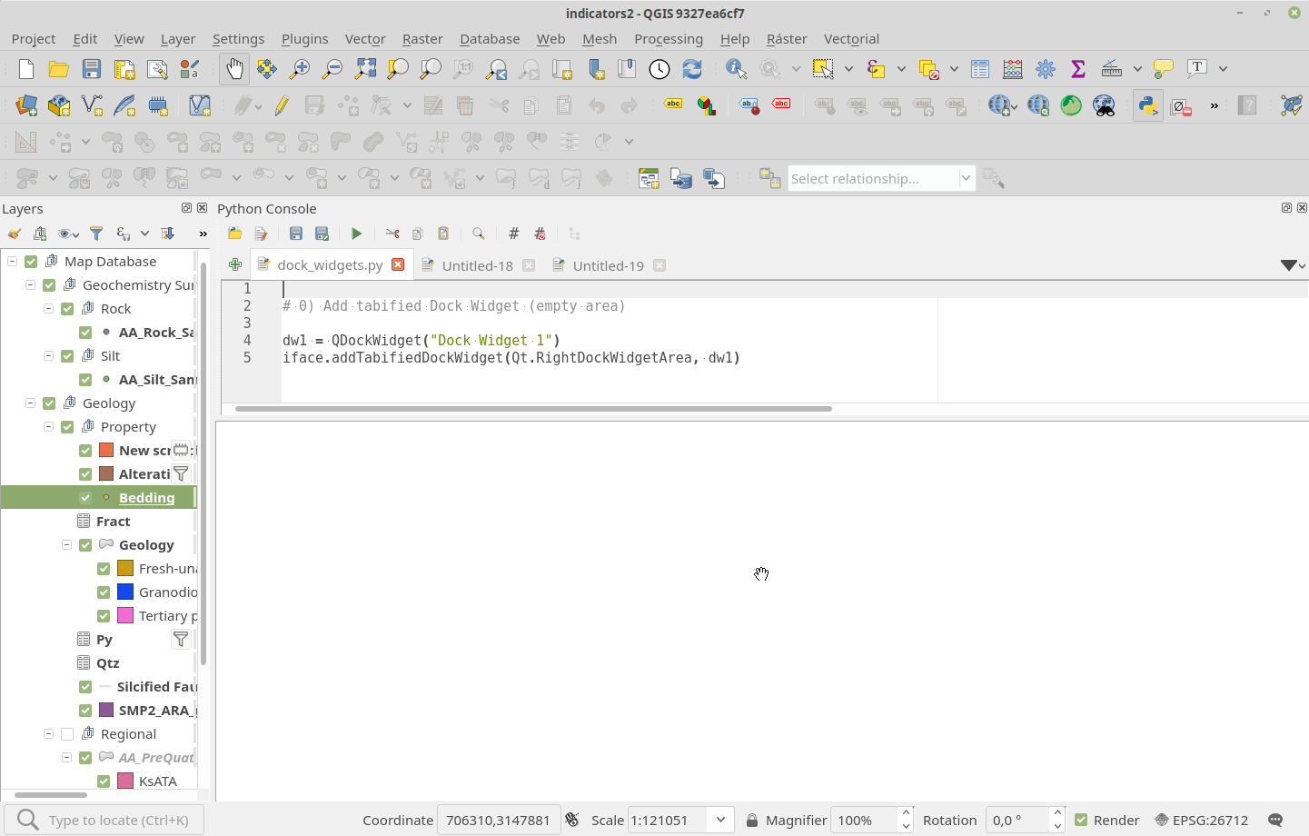
Спонсорская поддержка - SwissTierras Colombia
Разработчик - Germán Carrillo
Feature: Port output parameter wrappers to new API
Ports the output parameter wrappers (sinks, vector, raster, file and folder destinations) to the new c++ API for dialog and modeler.
This allows a range of new possibilities, including:
Models with static outputs for child algorithms, e.g. always saving a child algorithm’s output to a geopackage or postgres layer
Models with expression based output values for child algorithms, e.g. generating an automatic file name based on today’s date and saving outputs to that file
Refs NRCan Contract#3000707093
Разработчик - Nyall Dawson
Feature: Port last remaining input parameters to new API
This update ports the Raster Band input parameter and Multi Layer input parameter to the new C++ API.
Benefits include:
Expression based band/layer lists in models
Inline (non-blocking) lists for multi selection parameters (fields, bands, layer lists, enums)
Rearrangement of inputs for multi-layer parameters in models, to set specific layer orders
Refs NRCan Contract#3000707093
Разработчик - Nyall Dawson
Feature: Port Feature Source, Raster, Vector and Mesh Layer parameters to new API
It’s now possible to use expression-based layer sources in processing models.
Refs NRCan Contract#3000707093
Разработчик - Nyall Dawson
Feature: Vector tile layer - part 1
This is the initial work on vector tile layer support.
 (Красные линии - это не артефакты, они нарисованы специально, чтобы показать границы тайлов.)
Резюме
So far this only includes changes to the qgis_core library.
Main additions to the public API:
QgsVectorTileLayer - the main map layer class
QgsVectorTileRenderer - base class for renderer class implementations for vector tiles
QgsVectorTileBasicRenderer - default renderer implementation
New private classes (may be added to public API if needed):
QgsVectorTileLoader - handles fetching of tiles from network / mbtiles
QgsVectorTileMVTDecoder - handles decoding of raw tile data to features
QgsVectorTileLayerRenderer - takes care of overall rendering (fetch + decode + draw)
QgsVectorTileUtils - various useful functions
Some new classes that may be shared by vector and raster tiles:
QgsTileXYZ - position of a tile in tile matrix set (zoom level, column, row)
QgsTileRange - rectangular selection in a tile matrix (start/end column and row)
QgsTileMatrix - description of a tile matrix (map extent, zoom level, scale, number of rows/columns)
(also QgsTileMatrixSet to be added later when we support other tile matrix sets than just GoogleCRS84Quad)
Testing
You can load a vector tile layer from Python console, e.g.:
ds = QgsDataSourceUri() ds.setParam("type","xyz")
ds.setParam("url", "https://api.maptiler.com/tiles/v3/{z}/{x}/{y}.pbf?key=YOUR_FREE_API_KEY")
uri = bytes(ds.encodedUri()).decode('utf-8')
vtl = QgsVectorTileLayer(uri, "Vector Tiles Test")
QgsProject.instance().addMapLayer(vtl)
It is also possible to load vector tiles from a local MBTiles file - for «type» use «mbtiles» and for «url» use a local path (e.g. «/home/martin/x.mbtiles»).
There is currently no support for labeling.
Благодарности
Huge thanks to all funders who have contributed to the crowdfunding and made this possible - https://www.lutraconsulting.co.uk/blog/2020/04/02/vectortiles-donors
Спонсорская поддержка - Сообщество QGIS
Разработчик - Lutra Consulting (Martin Dobias)
Feature: Port processing extent parameter to new api, many other improvements
This update ultimately ports the extent parameter to the new c++ api, but along the way it:
Refactors the existing gui widget «QgsExtentGroupBox» to move the guts out to «QgsExtentWidget» (allowing it to be used in places where a group box is inappropriate/looks bad). It also adds a new «condensed» mode for the widget, because the default appearance is very space heavy.
The new parameter widget utilises this common QgsExtentWidget, so that we remove all the duplicate code which was previously used by the old python wrapper
Allows drag and drop of project map layers from the layer tree to a QgsExtentWidget to auto-set the extent to match
Allows QgsExtentWidget to be optionally nullable
Allows QgsGeometry values to be set for extent parameter values. This is done to aid use of extent parameters with the «precalculated value» mode in models – you can now use all the expression geometry functions to calculate a geometry and the bounding box of this is used for the parameter value in the child algorithm
Refs NRCan Contract#3000707093
Разработчик - Nyall Dawson
Feature: Interface and API for unified development/debugging tools
Adds interface hooks to allow plugins (and c++) to register «development/debugging» tools
These tools appear in a new Development/Debugging Tools dock, and provide a unified handling and place for these tools in the UI.
The intention here is that specialised development/debugging tools will be moved to this common interface, e.g.
Network logger
First aid style Python local variables inspector
Startup time debugging tools
Layer load and rendering time debugging tools … ?
Here’s an example demo showing a «Python locals» dev tool:
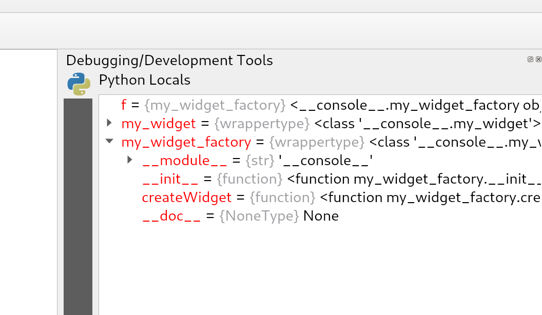
Разработчик - Nyall Dawson
Feature: Data type support for QgsProcessingParameterMapLayer
Allow the definition of accepted layer types for QgsProcessingParameterMapLayer. This is useful when an algorithm can work with different layer types (for example, points and rasters) and avoids duplication of the same algorithm with different inputs.
This is an API improvement and is not visible for the vast majority of users.
Разработчик - Alexander Bruy
Feature: Add processing parameter types for database schema and table name
Replaces the previous ad-hoc Python postgis widget wrappers with proper first class c++ dedicated parameters for schemas and tables, with wrappers built off the core connections api.
Refs NRCan Contract#3000707093
Разработчик - Nyall Dawson
Значительные исправления
Исправления ошибок от Alessandro Pasotti
Название ошибки |
URL адрес на issues.qgis.org (если было сообщено) |
URL адрес Коммита (Github) |
Коммит обратного порта для 3.10 (GitHub) |
|---|---|---|---|
Getfeatureinfo не показывает элементы отношений для QGIS Server |
Переведено в разряд предложений |
не применимо |
|
провайдер OGR QgsOgrProvider::changeAttributeValues возвращает true при ошибках |
не применимо |
||
Группы транзакций GPKG хранятся с пустой второй парой ключей |
|||
Символика, использующая отношения, не работает в QGIS Server |
не воспроизводимо |
не применимо |
|
Загрузка Растра из PostGIS приводит к падению QGIS 3.12.3 |
не применимо |
||
Значение GetFeatureInfo Fid отличается при запросе через application/json и application/vnd.ogc.gml |
|||
Уникальные ограничения уровня базы данных для GPKG (и spatialite) не поддерживаются в OGR (и spatialite) |
не применимо |
||
нет значения в форме атрибута, если значение отсутствует в карте значений |
не применимо |
||
Менеджер баз данных больше не показывает результаты запроса |
не применимо |
||
Менеджер баз данных больше не показывает результаты запроса |
не применимо |
||
Перетаскивание в браузере не работает для GPKG |
не зарегистрировано |
||
невозможно сохранить проект в geopackage |
не применимо |
||
Используя виджет редактирования даты/времени, можно было сохранить текст в числовом поле, что не правильно |
не применимо |
||
Создание объектов очень медленно при использовании связей |
не применимо |
||
Сервер QGIS: WFS Request не использует SrsName для геометрии |
не критично |
||
Невозможно удалить сохраненное соединение для geopackage из браузера |
|||
Ограничения: уникальное ограничение не корректно оценивается, когда 0 |
не применимо |
||
PyQgis: поля OriginJoin не представлены в контейнере QgsLayerVector QgsFields для слоев GeoPackage |
не воспроизводимо |
не применимо |
|
Связанные таблицы нельзя редактировать, даже если установлен флажок «редактируемый связанный слой» |
не воспроизводимо |
не применимо |
|
Удаление неиспользуемого метода allowMethod из qgisservice/qgisserverapi |
не применимо |
||
Гомогенизация заголовка окна |
не применимо |
||
Подписывание: невозможно активировать опцию формульных данных для настройки выравнивания |
|||
QGIS сообщает об отсутствии слоев в GeoPackage, когда каталог в котором он находится защищен от записи |
не критично (только интерфейс пользователя) |
||
Связанные таблицы нельзя редактировать, даже если установлен флажок «редактируемый связанный слой» |
не будет исправлено |
не применимо |
|
Отметки времени Postgis из запроса в Менеджере Баз данных отображаются как `PyQT5.QTCore.QDateTime (2020, 3, 17 |
не применимо |
||
Неправильный предпросмотр изображения и размер предварительного просмотра изображения в форме |
|||
не возможно изменить значение в редакторе вершин, если в настройках локали в качестве десятичного разделителя используются запятые |
|||
Идентификация слоя WMS с форматом «объект» аварийно завершает работу QGIS |
|||
Попытка создать новый объект в Spatialite с группой транзакций и ограничением NOT NULL завершается неудачей |
не будет исправлено |
не применимо |
|
Использование «Добавить объект» для создания объекта и дочернего объекта с группой транзакций приводит к ошибке внешнего ключа |
не критично |
||
В векторном слое spatialite отсутствуют объекты и неправильно считается их количество |
TODO |
Спонсорская поддержка - QGIS.ORG (через пожертвования и помощь постоянных членов)
Разработчик - Alessandro Pasotti
Исправления ошибок от Loïc Bartoletti
Название ошибки |
URL адрес на issues.qgis.org (если было сообщено) |
URL адрес Коммита (Github) |
Коммит обратного порта для 3.10 (GitHub) |
|---|---|---|---|
Исправлена ошибка, когда у векторного слоя есть Z координата |
|||
Исправлено построение прямоугольника по 3-м точкам |
|||
Разрешён поиск qmlplugindump по разным путям |
не применимо |
не применимо |
|
Исправлено отсутствие слов в расширенном виджете конфигурации |
PR #35643#issuecomment-610215386 |
не применимо |
|
Исправления интерполяции для Разбитой геометрии |
не применимо |
Спонсорская поддержка - QGIS.ORG (через пожертвования и помощь постоянных членов)
Разработчик - Loïc Bartoletti
Исправления ошибок от Even Rouault
Название ошибки |
URL адрес на issues.qgis.org (если было сообщено) |
URL адрес Коммита (Github) |
Коммит обратного порта для 3.10 (GitHub) |
|---|---|---|---|
Неправильная интерпретация кода EPSG из файла PRJ в QGIS-dev (proj v7.1.0) |
не применимо: проблема в PROJ |
||
Сбой QGIS при добавлении файла в geopackage -> слой -> поле (BLOB) |
|||
Плохое сообщение об ошибке при сбое подключения WFS |
|||
Сбой QGIS во время повторного рендеринга карты после переключения Системы координат |
не воспроизводимо |
не применимо |
|
QGIS аварийно завершает работу, если в контекстном меню последних проектов выбрать «открытый каталог» |
|||
Проблема перепроецирования растров в Системах координат 54019 и 54042 |
не применимо: проблема в PROJ |
||
ПРЕДУПРЕЖДЕНИЕ от провайдера WFS - Невозможно создать временный кэш SpatiaLite при установке через flatpak. |
не применимо |
||
Транзакция WFS с использованием URI GetCapabilities |
не применимо |
||
QGis 3.10.2 аварийно завершает работу при попытке отображения двух растровых слоев из PostGIS |
не применимо |
||
Сбой QGIS 3.4.10 - Python |
Уже исправлено в последней версии |
||
Провайдер WMS ожидает, ключевое слово SERVICE=WMTS в верхнем регистре для обнаружения WMTS |
|||
Ответ WCS DescribeCoverage всегда пуст |
|||
Неправильный экстент, если слой содержит точку в 0,0 |
Ошибка не связана с QGIS. Исправлено в GDAL 3.1 |
не применимо |
|
Проекция не распознается из конвертации из Mapinfo |
|||
QGIS падает/зависает при добавлении большого CSV-файла в виде текстового слоя с разделителями |
|||
QGIS 3.12 неизвестная Система координат или выбор Преобразования |
|||
Ошибка BIGTIFF не очевидна в журнале обработки |
Спонсорская поддержка - QGIS.ORG (через пожертвования и помощь постоянных членов)
Разработчик - Even Rouault
Исправление ошибок - Paul Blottiere
Название ошибки |
URL адрес на issues.qgis.org (если было сообщено) |
URL адрес Коммита (Github) |
Коммит обратного порта для 3.10 (GitHub) |
|---|---|---|---|
Исправлена ошибка при добавлении слоя |
не применимо |
||
Исправлен сигнал подключения |
О проблеме не сообщалось |
не применимо |
|
Обновление API для экспорта легенды в JSON |
Проблема привязки о которой не сообщалось |
не применимо |
|
Дамп ядра, если Слой векторных тайлов (файл) становится недоступным |
не воспроизводимо |
не применимо |
|
Сбой при открытии проекта, когда mapcanvas extents = nan |
не воспроизводимо |
не применимо |
|
Использование некоторых функций в растровом калькуляторе ведёт к сбою в QGIS |
не применимо |
||
Вспомогательное хранилище невозможно использовать в нередактируемом слое |
Уже исправлено. |
не применимо |
|
Исправления для корректной компиляции в GCC 10, Qt/PyQt 5.15.0 и SIP 4.19.23 |
Спонсорская поддержка - QGIS.ORG (через пожертвования и помощь постоянных членов)
Разработчик - Paul Blottiere
Исправления ошибок от Julien Cabieces
Название ошибки |
URL адрес на issues.qgis.org (если было сообщено) |
URL адрес Коммита (Github) |
Коммит обратного порта для 3.10 (GitHub) |
|---|---|---|---|
Воспроизводимый сбой с использованием QgsMapCanvas.items () со слоями Oracle |
|||
Разрывы строк игнорируются в панели справки пользовательских выражений |
|||
«Редактировать пользовательское выражение» не позволяет его переименовать |
не применимо |
||
Невозможно изменить подписи классов растровых символов |
|||
Сбой, когда слой недоступен |
не воспроизводимо |
не применимо |
|
Выборка по выражению возвращает ошибочные результаты с целочисленным делением поля для шейп-файлов |
не применимо |
||
Использование concat(field1, field2) объединяет 0 вместо пустой строки („“), если любое из полей имеет значение NULL |
|||
Зависание в окне последних проектов при открытии пустого файла в 3.10.3 |
не воспроизводимо |
не применимо |
|
Сбой QGIS при получении элементов сцены mapCanvas, если объекты определены |
|||
сортировка по столбцу, с настроенным отношением, является непоследовательной |
|||
Потеря точек (в зависимости от масштаба холста) в виртуальном слое на основе файла sqlite |
|||
Проект считается изменённым, как только вы перемещаете курсор |
|||
Установка фильтра, приводит к неправильной «версии» таблицы, когда в слое используется несколько типов геометрии |
Спонсорская поддержка - QGIS.ORG (через пожертвования и помощь постоянных членов)
Разработчик - Julien Cabieces
Исправления ошибок от Bertrand Rix
Название ошибки |
URL адрес на issues.qgis.org (если было сообщено) |
URL адрес Коммита (Github) |
Коммит обратного порта для 3.10 (GitHub) |
|---|---|---|---|
Инструмент редактирования вершин переопределяет глобальные параметры привязки |
не применимо |
||
Сбой QGIS при попытке использования метода QgsGeometry на пустой коллекции |
не применимо |
||
Выборочное маскирование: фантомные линии на темном фоне |
не применимо |
||
Выборочное маскирование: проблема с непрозрачностью маски |
не применимо |
Спонсорская поддержка - QGIS.ORG (через пожертвования и помощь постоянных членов)
Разработчик - Bertrand Rix
Исправления ошибок от Sebastien Peillet
Название ошибки |
URL адрес на issues.qgis.org (если было сообщено) |
URL адрес Коммита (Github) |
Коммит обратного порта для 3.10 (GitHub) |
|---|---|---|---|
[Oracle]Error on save geometries because wrong default values #34482 |
не применимо |
||
Неверный запрос для значения по умолчанию столбца даты слоя Oracle |
не применимо |
||
Поля, отсутствуют в списке выбора для «Видимости по выражению» для группы в форме перетаскивания |
не применимо |
||
Пользовательские масштабы проекта отформатированы в научной нотации |
не применимо |
||
Oracle: таблицы перечислены один раз для полигонов и один раз для мультиполигонов, но обе показывают всю геометрию |
не применимо |
||
Невозможно установить минимальные/максимальные значения в десятичных для растровой символики в QGis на Linux |
не применимо |
Спонсорская поддержка - QGIS.ORG (через пожертвования и помощь постоянных членов)
Разработчик - Sebastien Peillet
Исправления ошибок от Alexander Bruy
Название ошибки |
URL адрес на issues.qgis.org (если было сообщено) |
URL адрес Коммита (Github) |
Коммит обратного порта для 3.10 (GitHub) |
|---|---|---|---|
При копировании усеченной переменной копируется усеченный текст, а не оригинал |
|||
Отключение режима Мультиправки не возвращает к режиму просмотра таблицы |
|||
Инструменты GRASS: отсутствует название параметра |
|||
Исправлено перенаправление результатов стандартного вывода во временные файлы в алгоритмах обработки GRASS. |
не зарегистрировано |
||
Исправлен алгоритм GRASS r.tileset |
не зарегистрировано |
||
QgsRasterTerrainAnalysisPlugin: проверка значения возвращаемого QgsRelief::processRaster() |
|||
Гистограмма для градуированного стиля в свойствах слоя исчезает, когда окно свойств слоя слишком маленькое |
|||
Экспорт изображения с параметром атласа «Сохранить файл привязки» приводил к неправильному именованию файла привязки (отсутствует текст после точки) |
|||
Кнопка «Перезапустить QGIS» из диалогового окна отчета о сбое не может открыть проект заново |
|||
Экспорт стиля растра в SLD работает только тогда, когда выходной файл имеет суффикс .sld |
|||
[Диспетчер стилей] Отсутствует категория «Избранное» в диалоговом окне «Выбор по группе» в разделе «Экспорт символов» |
не критично |
||
TIN Интерполяция - проблемы с форматом и размером выходного растра |
|||
Панель Слоёв: «Редактировать символ» ничего не делает, если для правила не определен символ (при рендеринге на основе правил) |
не критично |
||
Смещение атрибутов в результатах алгоритма «Область обслуживания» |
не зарегистрировано |
не применимо |
|
Среда тестирования не применяет округление к значениям, приведенным к числам |
не зарегистрировано |
не применимо |
Спонсорская поддержка - QGIS.ORG (через пожертвования и помощь постоянных членов)
Разработчик - Alexander Bruy
Исправления ошибок от Nyall Dawson
Название ошибки |
URL адрес на issues.qgis.org (если было сообщено) |
URL адрес Коммита (Github) |
Коммит обратного порта для 3.10 (GitHub) |
|---|---|---|---|
Исправить утечку в рендерере 3d mesh сетки |
не зарегистрировано |
не применимо |
|
Исправлено зависание при рендеринге символов с использованием размера в Метрах в Масштабе карты |
Нет - слишком комплексно |
||
Исправлен шрифт в редакторе кода CSS |
не зарегистрировано |
не критично |
|
Исправлен рендеринг выражений генератора геометрии, которые возвращают Коллекции геометрии в качестве результата |
Нет - слишком комплексно |
||
[Инструменты] Правильное представление входных данных даты (и кучу других) в качестве входных данных для выражений в модели |
не применимо |
||
Исправьте все предупреждения об устаревании Qt 5.14 |
не зарегистрировано |
Нет - слишком комплексно |
|
[символика] Проверка при рендеринге составной геометрии, что символ генератора геометрии отображается только один раз, а не один раз для каждой детали. |
Нет - слишком комплексно |
||
[Листы] Сделайте так, чтобы кнопка «Показывать количество объектов» применялась ко всем выбранным индексам |
Нет - слишком комплексно |
||
Исправлена ошибка, из-за которой параметр «показывать как групповой контейнер» сбрасывался при закрытии диалога свойств слоя |
не применимо |
||
Более настойчиво отговаривать пользователей от создания пользовательских проекций с использованием формата Proj строки |
Нет |
||
Более последовательное использование термина «маркеры» в виджете заливки центроидами |
Нет |
||
Исправлена обработка нумерованных списков в dox/PyQGIS API |
не зарегистрировано |
Нет |
|
Исправление перекрестных ссылок в документах PyQGIS |
не зарегистрировано |
Нет |
|
[макеты] Исправлен порядок сортировки таблицы атрибутов в сочетании с результатами фильтра объектов в пустых таблицах. |
не применимо |
||
Исправлен рендеринг выноски для повернутых подписей |
не применимо |
||
Исправлена обработка вывода grass в Моделях |
|||
Исправление неправильного упрощения векторных данных до прямоугольников в некоторых Системах координат |
Нет - слишком комплексно |
||
Исправлено форматирование элементов списка в документации PyQGIS |
не зарегистрировано |
не применимо |
|
[инструменты анализа] Исправление ручного ввода значений экстентов в виджет |
не применимо |
||
[Оформление] Правильный расчет длины эллипсоида при расчете размера Шкалы масштаба |
|||
Исправлен сбор типов геометрии треугольников после Тесселяции |
Нет - слишком комплексно |
||
Исправлена ошибка при записи типа геометрии треугольника через QgsVectorFileWriter |
Нет - слишком комплексно |
||
Исправлено ухудшение результатов Тесселяции |
не применимо |
||
Исправлено игнорирование строки подмножества слоя, когда OGR отказывается принимать скомпилированное выражение запроса объекта |
|||
[легенда] Исправлено отображения поврежденных легенд на основе формульных данных, в дизайнере макетов. |
Нет - слишком комплексно |
||
Убраны некоторых предупреждений при запуске QGIS |
не зарегистрировано |
не применимо |
|
Перемещение вкладки 3d в свойствах векторного слоя на правильное место |
не применимо |
||
Исправлено: 3d вкладка не активируется при повторном открытии свойств векторного слоя |
не применимо |
||
[подписывание] Исправлено неправильное размещение после перемещения «неразмещенной» подписи |
не зарегистрировано |
||
Возможность создание новых geopackage файлов в диалоге Вектор -> Сохранить как |
не зарегистрировано |
не применимо |
|
[браузер] Переработка метода refreshConnections, чтобы избежать полного обновления всего содержимого браузера. |
Нет - слишком комплексно |
||
[3d] При отображении ребер полигона не учитывались высота заданная формульными данными |
не зарегистрировано |
не применимо |
|
Исправления для режима Подписей «Показать все» |
не зарегистрировано |
не применимо |
|
[3d] Исправлено: объекты не отображаются после перепроецирования |
не применимо |
||
[инструменты] Добавлена настройка метаданных для параметров пути назначения файла, чтобы избежать запроса подтверждения перезаписи файла |
не применимо |
||
Исправление некорректного сглаживания при рендеринге определенных объектов (например, подписей), когда они не нужны |
Нет - слишком комплексно |
||
Проверка, что поля, требуемые для фоновой заливки задника подписей, выбираются при рендеринге |
Нет - слишком комплексно |
||
«Исправлены кнопки «приблизить» и «помигать» которые не работали в режиме фильтра в форме атрибутов» |
не применимо |
||
Избежание риска поврежденных эскизов проекта в некоторых обстоятельствах |
не зарегистрировано |
не применимо |
|
Автофокус на поле поиска при открытии диалога «Добавить слой к легенде» |
не критично |
||
[инструменты] Установка правильного типа выходного слоя для алгоритма Point to Layer |
не применимо |
||
«Ограничение области действия сочетания клавиш Ctrl + C для копирования объектов на холст и для консоли Python в виджет консоли» |
#27035 (many others too) |
Нет - слишком комплексно |
|
Запомнинание расположение окон Дизайнера макетов |
не критично |
||
Исправлено аварийное завершение при слишком большом приближении к подписям |
|||
[инструменты] Разрешить указание родительского слоя для входных данных отображения полей в моделях |
Нет - слишком комплексно |
||
Исправлено размещение стрелки выпадающего меню «очистить все» панели информации на экранах hidpi. |
не зарегистрировано |
не критично |
|
Обновление репозитория плагинов, при ручном запуске пользователем |
|||
[3d] Доступ к провайдеру 3d алгоритмов через Python |
Нет - слишком комплексно |
||
[символика] Убрана принудительная растеризация при экспорте заливок узором |
Нет - слишком комплексно |
||
[макеты] При экспорте атласа холст не будет обновляться несколько раз |
не критично |
||
[инструменты анализа] Исправлена двойная оценка выходного параметра деформации |
|||
Исправлено неверное предупреждающее сообщение при отключении предварительного просмотра атласа |
не зарегистрировано |
не применимо |
|
Ускорение работы панели сообщений, когда их отображается много |
Нет - слишком комплексно |
||
Исправлен расчет минимальной ограничительной рамки, который в некоторых случаях давал неверный результат |
|||
Проверка что непрозрачность символа всегда игнорируется при выделении |
|||
Исправлен случайный порядок сортировки символов в диалоге Экспорта Символов |
|||
Разрешено обнулять поле весов тепловой карты |
|||
Алгоритм SAGA „Merge Layers“ помечен как «имеющий известные проблемы» |
не применимо |
||
Обход проблемы в библиотеке Qt , когда для полупрозрачной заливки без сплошного узора неправильно применяется прозрачность к контуру при отправке на принтер |
|||
Улучшения в контроллере плагинов и его интерфейсе |
не зарегистрировано |
Нет - слишком комплексно |
|
«[макеты] Вывод предупреждения при предварительном просмотре атласа в котором встречается объект без геометрии, когда одна или несколько карт настроены на управление объектом атласа» |
Нет - слишком комплексно |
||
Подавление предупреждений proj «object is not a concatenated operation» |
не зарегистрировано |
||
«Исправление Временных слоёв, которые в некоторых случаях теряли информацию о заданной Системе координат» |
|||
Реализовано обнаружение пространственного индекса для провайдера OGR |
|||
Исправлен неверный заголовок диалога Свойств растрового слоя |
|||
Исправлена ошибка, когда Определения созданные для эллипсоидов, идентифицировались как Системы координат |
не зарегистрировано |
Нет - слишком комплексно |
Спонсорская поддержка - QGIS.ORG (через пожертвования и помощь постоянных членов)
Разработчик - Nyall Dawson
Исправления ошибок от Denis Rouzaud
Название ошибки |
URL адрес на issues.qgis.org (если было сообщено) |
URL адрес Коммита (Github) |
Коммит обратного порта для 3.10 (GitHub) |
|---|---|---|---|
Разрешена сортировка таблицы атрибутов по полю, не отображаемому в таблице |
не применимо |
||
исправлены зависимости дерева слоев (символы showinf и основной слой) |
не зарегистрировано |
не применимо |
|
исправлен редактор выражений: проверка синтаксиса завершается неудачно, если таблица пуста |
не применимо |
||
исправлена настройка функции в виджете предварительного просмотра выражений |
не применимо |
||
Исправлено зависание при отображении таблицы атрибутов слоя WFS |
ещё не исправлено |
не применимо |
|
Поиски в таблицах с более чем 100 записями показывал неправильные значения в Связанных отношением частях формы |
Спонсорская поддержка - QGIS.ORG (через пожертвования и помощь постоянных членов)
Разработчик - Denis Rouzaud
Исправления ошибок от Audun Ellertsen
Название ошибки |
URL адрес на issues.qgis.org (если было сообщено) |
URL адрес Коммита (Github) |
Коммит обратного порта для 3.10 (GitHub) |
|---|---|---|---|
Поддержка бинарными полями при импорте SpatiaLite слоёв |
не применимо |
||
PostGIS support for importing layers with binary fields |
Спонсорская поддержка - Kongsberg Digital
Разработчик - Audun Ellertsen