Jurnalul schimbărilor pentru QGIS 3.24
Data lansării: 2022-02-18
In memoriam: Această versiune poartă numele «Tisler» după o mică insulă norvegiană, locul pe care prefera să-l viziteze Håvard Tveite, cel care a murit în mai 2021. Håvard, un membru foarte activ al comunității QGIS, a oferit contribuții valoroase la documentație, a dezvoltat numeroase plugin-uri și a avut grijă de Depozitul de Partajare a Resurselor QGIS, pentru a numi doar câteva dintre contribuțiile sale. Harta de pe ecranul QGIS 3.24 este o hartă de orientare pe care a creat-o Håvard. Îi plăcea să petreacă ceva timp în fiecare an făcând hărți la Tisler.
Dorim să mulțumim dezvoltatorilor, creatorilor documentației, testerilor și voluntarilor pentru timpul dedicat și pentru efortul depus (sau pentru că au finanțat anumite persoane în scopurile enumerate) făcând aceste versiuni posibile. Din partea comunității QGIS, vă urăm să vă bucurați de această versiune! Dacă doriți să contribuiți cu efort, bani sau să vă implicați într-un mod care ar putea îmbunătăți QGIS, vă rugăm să vizitați QGIS.ORG și să oferiți o mână de ajutor!
Pentru o trecere în revistă al tuturor noilor funcționalități introduse, puteți viziona videoclipul evidențiat pe youtube la https://youtu.be/gVgR4Oxqtkk
QGIS este susținut din donații și prin programul membrilor susținători. Lista curentă a celor care au contribuit financiar la acest proiect poate fi consultată aici. Dacă doriți să deveniți un membru susținător oficial al proiectului, vă rugăm să vizitați pagina membrilor susținători. Sponsorizările QGIS ne ajută să finanțăm întâlnirea dezvoltatorilor o dată la șase luni, să menținem infrastructura proiectului și să finanțăm eforturile de eliminare a erorilor. În continuare este prezentată lista completă a sponsorilor actuali - acestora le transmitem mulțumirile noastre!
QGIS este un soft gratuit iar dvs. nu aveți obligația de a plăti pentru folosirea lui - de fapt, vrem să încurajăm oamenii de pretutindeni să-l folosească, indiferent de starea financiară sau socială - având convingerea că, oferind utilizatorilor posibilități de decizie spațială, vom obține o societate mai bună.
Interfața cu Utilizatorul
Funcționalitate: Preluarea extinderilor hărții direct din compoziții și din repere spațiale
Această facilitate aduce multă economie de timp! Controlul grafic al extinderii din QGIS permite, de acum, preluarea extinderilor hărților direct din compozițiile și reperele spațiale ale proiectului.
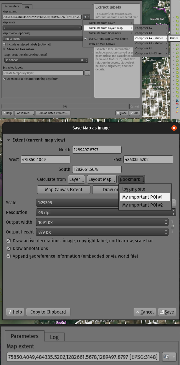
Această funcționalitate a fost dezvoltată de Mathieu Pellerin
Funcționalitate: Personalizarea mai ușoară a sistemelor de referință a coordonatelor
Am adăugat o nouă opțiune atunci când selectați un Sistem de Referință a Coordonatelor (CRS), care vă permite să introduceți direct o definiție CRS (din șirurile proj sau WKT), în loc să vă ceară să adăugați mai întâi CRS-ul personalizat în baza de date a proiecțiilor.
De acum, este mult mai ușoară definirea unei proiecții personalizate pentru o utilizare cu un singur scop, de ex.: o hartă de ansamblu cu o proiecție concepută pentru o locație cu latitudine și longitudine particulare.

Această funcționalitate a fost dezvoltată de Nyall Dawson
Simbologie
Funcționalitate: Marker/Linie hașurată: decalare în lung de linie cu un „procentaj” din lungimea liniei (pot exista și decalaje negative!)
De acum puteți specifica decalajul în lung de linie, în procente, atât pentru markere cât și pentru liniile hașurate. (Aceste decalaje sunt calculate ca procente din lungimea totală a liniei).
În plus, atunci când decalajul în lung de linie, pentru un marker sau o hașură liniară, depășește dimensiunea unui inel închis, QGIS va continua decalarea de-a lungul inelului, cu valoarea care depășește 100%. De exemplu, setarea decalajului la 150% conduce la tratarea decalării la 50% din lungimea inelului închis.
De asemenea, este posibilă specificarea unui decalaj negativ în lung de linie pentru un inel închis. Decalajele negative sunt calculate în sens invers, de-a lungul inelului.
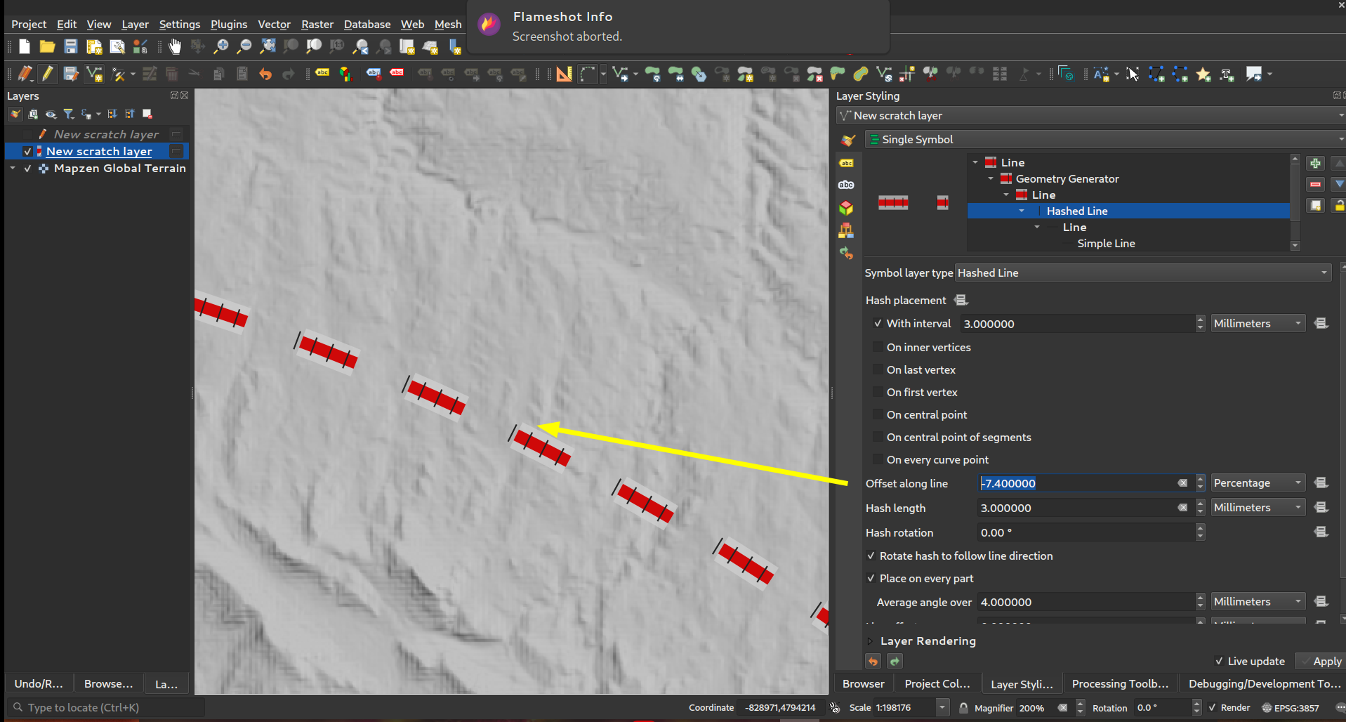
Această funcționalitate a fost finanțată de North Road cu sprijinul SLYR
Această funcționalitate a fost dezvoltată de Nyall Dawson
Funcționalitate: Posibilitate de poziționare pe primul/ultimul vertex al fiecărei părți dintr-o geometrie cu părți multiple
Această nouă opțiune de simbolizare permite poziționarea Markerelor și Liniilor Hașurate pe Primul și pe Ultimul Vertex al fiecărei părți dintr-o linie (ori poligon) cu părți multiple, sau numai pe primul sau pe ultimul vertex din întreaga geometrie cu părți multiple.
Această funcționalitate a fost finanțată de North Road cu sprijinul SLYR
Această funcționalitate a fost dezvoltată de Nyall Dawson
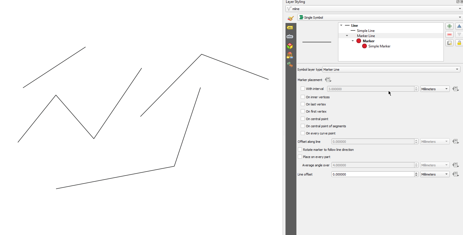
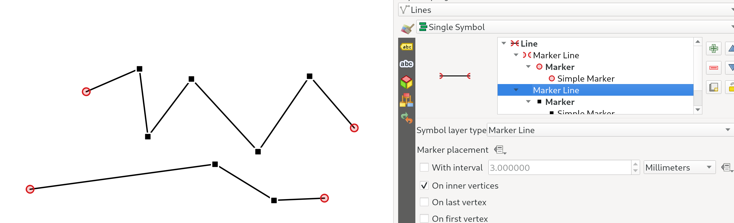
Funcționalitate: Posibilitate de înlocuire a poziționării „pe vertecșii” Markerelor/Liniilor hașurate cu poziționarea „pe vertecșii interiori”
Noul mod Pe Vertecșii Interiori plasează simbolurile doar pe vertecșii interiori (adică toți vertecșii, cu excepția primului sau ultimului).
Anterior, vechiul mod „Vertex” poziționa simbolurile pe primul și pe ultimul vertex, făcând practic imposibilă stilizarea unei linii cu un marker diferit pe primul sau ultimul vertex comparativ cu restul vertecșilor liniei. Noua opțiune de poziționare Pe Vertecșii Interiori, permite crearea unui stil în care o linie are un marker diferit pe primul sau pe ultimul vârf comparativ cu restul vertecșilor!
(Această modificare se îmbină în mod armonios cu utilizarea casetelor de bifare pentru opțiunile de plasare – pentru a obține un marker care să se afișeze pe toate nodurile, asigurați-vă că sunt bifate opțiunile pentru vertecșii interiori, primul și ultimul).
Această funcționalitate a fost finanțată de North Road cu sprijinul SLYR
Această funcționalitate a fost dezvoltată de Nyall Dawson
Funcționalitate: Controlarea modelului culorii utilizate la interpolarea rampelor gradienților
La momentul generării rampei unui gradient, unele combinații de culori vor face ca rampa să treacă prin tonuri medii de gri obscure, dacă interpolarea este efectuată folosindu-se în mod independent canalele roșu/verde/albastru. O abordare alternativă este de a interpola culorile prin canalele de nuanță/saturație/luminozitate sau valoare. În acest fel se pot evita tonurile medii desaturate, rezultând gradienți mai plăcuți.
De acum, specificarea culorii poate fi setată per stop într-un gradient de culoare cu mai multe opriri, pentru a oferi utilizatorilor control asupra tehnicii interpolării de folosit. Există, de asemenea, opțiunea de a controla direcția interpolării pentru componenta Hue a specificațiilor de culoare HSL/HSV, evitând, în unele circumstanțe, parcurgerea întregului spectru de nuanțe!
Acest video arată tonurile medii ale unei rampe de culoare, unde interpolarea RGB are ca rezultat culori tulburi, în timp ce interpolarea HSL/HSV rămâne frumoasă și vibrantă.
Această funcționalitate a fost finanțată de North Road cu sprijinul SLYR
Această funcționalitate a fost dezvoltată de Nyall Dawson
Funcționalitate: Miniaturi redimensionabile în dialogul managerului de stiluri
Am adăugat un nou glisor pentru a controla dimensiunea miniaturilor din fereastra managerului de stiluri, întrucât uneori dimensiunile miniaturilor sunt prea mici pentru a se obține o bună reprezentare!
Această funcționalitate a fost finanțată de North Road cu sprijinul SLYR
Această funcționalitate a fost dezvoltată de Nyall Dawson
Funcționalitate: Simboluri „Lineburst”
Am adăugat un nou tip de strat pentru simboluri, „Lineburst”, care generează un gradient de-a lungul lățimii unei linii (spre deosebire de Linia Interpolată, care redă un gradient de-a lungul lungimii unei linii). Este ceva similar tipului de umplere Shapeburst, dar pentru linii!
Această funcționalitate a fost finanțată de North Road cu sprijinul SLYR!
Această funcționalitate a fost dezvoltată de Nyall Dawson
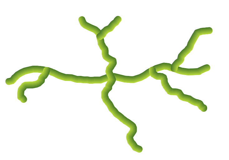
Funcționalitate: Simboluri de tip „Linie Raster”
Suntem foarte încântați să vă oferim acest nou tip de simbol liniar, care permite generarea unei imagini raster prin urmărirea formei unei entități liniare. Acest tip de simbol deschide un domeniu cu totul nou de posibilități pentru simbologia QGIS, fiind util mai ales atunci când se creează hărți în stilul unui desen sau al unei picturi clasice.
Există opțiuni pentru a controla:
calea imaginii (inclusiv calea definită de date)
lățimea liniei
opacitatea
stilurile de îmbinare a liniilor
Această funcționalitate a fost finanțată de North Road cu sprijinul SLYR
Această funcționalitate a fost dezvoltată de Nyall Dawson
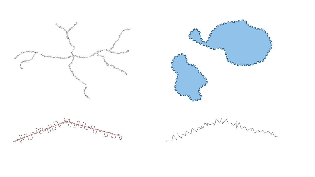
Funcționalitate: Alegerea comportamentului de tăiere pentru umplerile cu modele liniare
De acum se poate controla modul în care sunt tăiate la forma unui poligon, liniile dintr-un simbol de umplere cu model liniar. Opțiunile disponibile sunt:
Decupare doar pe durata randării: se creează linii de acoperire a întregii casete de încadrare a entității, care ulterior sunt tăiate în timpul desenării. Extremitățile liniilor (începutul și sfârșitul) nu vor fi vizibile (același comportament din versiunile QGIS anterioare).
Decupare linii înainte de randare: liniile sunt tăiate la forma exactă a poligonului înaintea randării. Extremitățile liniei (stilurile capetelor de linie, markerele de la începutul/sfârșitul liniilor etc.) vor fi vizibile și uneori se pot extinde în afara poligonului (în funcție de setările simbolului liniar).
Fără tăiere: nu se efectuează nicio tăiere - liniile vor acoperi întreaga casetă de încadrare a entității
Această funcționalitate a fost finanțată de North Road cu sprijinul SLYR
Această funcționalitate a fost dezvoltată de Nyall Dawson
Funcționalitate: Randare îmbunătățită a umplerilor cu modele liniare
De acum, la exportarea într-un format vectorial (cum ar fi PDF sau SVG) sau atunci când un sub-simbol liniar are proprietăți dinamice (definite de date), are loc o abordare de umplere automată, linie-cu-linie. (Anterior, s-a utilizat umplerea cu plăcuțe a modelului, ceea ce a produs adesea artefacte nedorite și cusături vizibile în cadrul modelului).
Unele dintre numeroasele beneficii ale acestei schimbări sunt următoarele:
Dimensiuni mai mici ale fișierelor de ieșire PDF/SVG – umplerile modelului de linii nu sunt stocate ca imagini raster la ieșire, astfel încât dimensiunea generală a fișierului va fi adesea mult mai mică
Pentru post-producție, fișierele PDF/SVG exportate sunt mai ușor de modificat în aplicații externe (cum ar fi Inkscape sau Adobe Illustrator), întrucât fiecare linie individuală a modelului poate fi modificată.
Fișiere PDF/SVG de calitate mai bună, deoarece umplerea nu depinde de DPI, iar pixelii arată perfect, indiferent de nivelul de mărire
Nu există artefacte vizibile la diverse unghiuri, distanțe sau la folosirea anumitor stiluri de simboluri liniare
Și chiar mai interesant, se deschide ușa unei serii noi de stiluri pentru simboluri, cum ar fi:
modele linare în care fiecare linie își schimbă culoarea/lățimea/forma/ etc.
modele liniare cu markere plasate pe punctul central/etc
efecte în generatorul de geometrie pentru fiecare linie, cum ar fi modele de linii ondulate, stil de linie desenată manual etc
Această funcționalitate a fost finanțată de North Road cu sprijinul SLYR
Această funcționalitate a fost dezvoltată de Nyall Dawson
Funcționalitate: Unghiul de rotație pentru umplerile cu modele de puncte
Acum puteți specifica un unghi de rotație opțional pentru umplerile cu modele de puncte, ceea ce face ca orice model să poată fi înclinat. Acest lucru poate fi extrem de util atunci când sunt suprapuse mai multe umpleri cu modele de puncte!
Această funcționalitate a fost finanțată de North Road cu sprijinul SLYR
Această funcționalitate a fost dezvoltată de Nyall Dawson
Funcționalitate: Decalaje aleatorii ale punctelor pentru umplerea modelului de puncte
Această setare (opțională) permite ca fiecare punct dintr-un model de umplere să se deplaseze aleatoriu până la distanța maximă specificată, în direcția x sau y. Se poate specifica decalajul maxim în milimetri, puncte, unități de hartă sau chiar „procentaje” (procentajul fiind raportat la lățimea sau înălțimea modelului).
Se poate stabili o valoare de inițializare, opțională, pentru generatorul de numere aleatorii, pentru a evita ca modelul să se „piardă” la reîmprospătarea hărții. De asemenea, sunt acceptate suprascrieri definite de date.
Principala diferență dintre această nouă setare și tipul de umplere aleatorie a markerului existent este că decalarea aleatorie a unui model de puncte permite poziționarea cvasi-„regulată” a markerelor – întrucât punctele din model sunt limitate efectiv la o grilă, permițând crearea de umpleri semi-aleatorii care nu au zone goale sau markere suprapuse. (Spre deosebire de umplerea aleatorie a markerului, care va plasa întotdeauna punctele complet aleatoriu… rezultând uneori aglomerări de puncte sau zone goale nedorite).
Această funcționalitate a fost finanțată de North Road cu sprijinul SLYR
Această funcționalitate a fost dezvoltată de Nyall Dawson
Funcționalitate: Setarea modului de referință a coordonatelor pentru straturile simbolurilor umplute cu modele liniare sau cu modele de puncte
Straturile simbolurilor umplute cu modele liniare și modele de puncte au o nouă setare pentru modul de referință a coordonatelor, care permite ajustarea ancorării modelelor. Practic vorbind, acest lucru permite modelelor să se alinieze armonios între entitățile adiacente și cele suprapuse.

Această funcționalitate a fost dezvoltată de Mathieu Pellerin
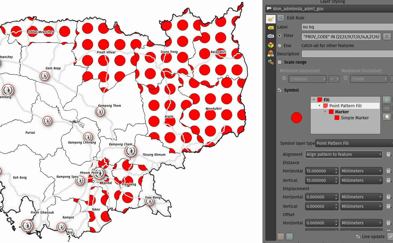
Funcționalitate: Control asupra decupării modelului de puncte care umple un marker
Această nouă opțiune oferă control asupra modului în care este decupat modelul de puncte care umple markerele. Opțiunile disponibile sunt:
Decupare după formă: modelele vor fi decupate la limita formei, astfel încât „decuparea” va fi evidentă (același comportament din versiunile QGIS anterioare)
Centroidul markerului în interiorul formei: punctele vor fi desenate numai dacă centroidul lor se încadrează în formă, punctele nefiind tăiate la limita formei
Marker complet inclus în formă: punvtele vor fi desenate numai dacă se potrivesc complet în formă
Fără tăiere: punctele vor fi desenate dacă orice parte a acestora, indiferent cât de mică, intră în cadrul formei
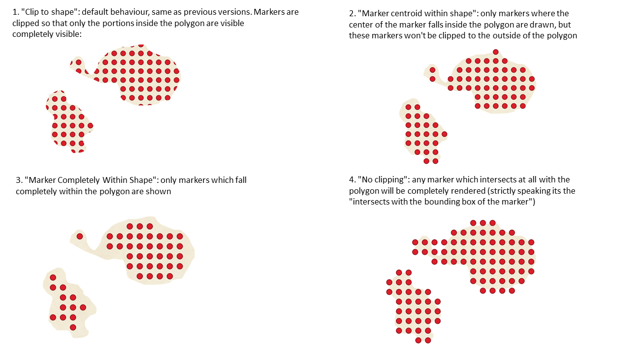
Această funcționalitate a fost finanțată de North Road cu sprijinul SLYR
Această funcționalitate a fost dezvoltată de Nyall Dawson
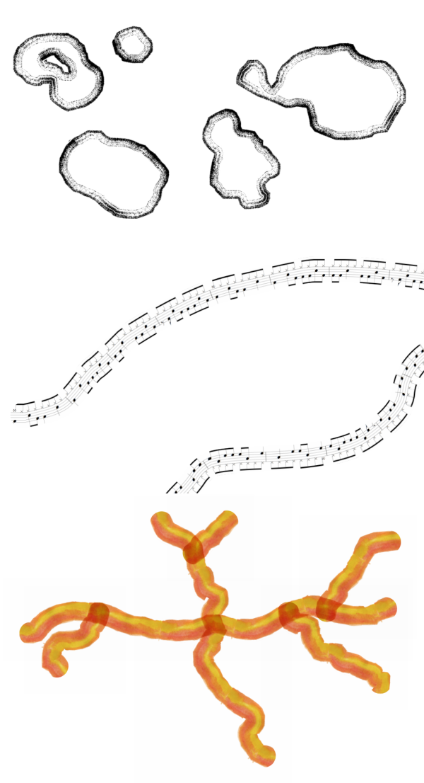
Funcționalitate: Funcții dedicate creării undelor triunghiulare/pătrate/curbe
S-au adăugat unele funcții care produc „linii ondulate” de-a lungul limitelor unei geometrii. Printre formele undelor sunt incluse:
Unde (similare celor sinusoidale)
Triunghiulare
Pătratice
În plus, au fost adăugate și funcții dedicate creării undelor într-o manieră clasică sau cu randomizare.
Atunci când sunt utilizate cu generatoare de geometrie, aceste expresii pot fi folosite pentru unele efecte cartografice foarte avansate!
Această funcționalitate a fost finanțată de North Road cu sprijinul SLYR
Această funcționalitate a fost dezvoltată de Nyall Dawson
Etichetare
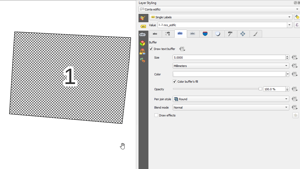
Funcționalitate: unități de tip „Procentaj” pentru dimensiunea zonei tampon din jurul textului, pentru decalarea umbrelor și raza efectului de estompare
De acum, este permisă stabilirea ca procent din dimensiunea fontului în cazul dimensiunilor pentru zona tampon din jurul textului de text, pentru decalarea umbrei și a razei de estompare. Acest lucru este de dorit pe măsură ce dimensiunea textului este schimbată, deoarece permite crearea unor formate de text în care componentele se scalează aspectuos, în loc să aibă o zonă tampon/umbră cu dimensiuni fixe care trebuie ajustate independent.
Această funcționalitate a fost finanțată de North Road cu sprijinul SLYR
Această funcționalitate a fost dezvoltată de Nyall Dawson
Funcționalitate: Poziții definite de date pentru etichete, în funcție de geometriile de tip punct
De acum, poziționarea definită de date a etichetelor se poate lega de câmpul unei geometrii de tip punct sau printr-o expresie. (Versiunile anterioare de QGIS permiteau poziționarea definită cu ajutorul datelor prin intermediul a două câmpuri numerice x și y separate).
Această modificare permite, de asemenea, utilizarea instrumentului de Mutare a etichetei, orice schimbare a poziției etichetei stocându-se într-un atribut, sub formă de geometrie de tip punct.
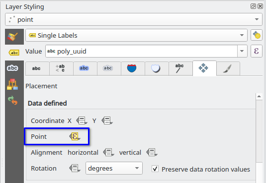
Această funcționalitate a fost finanțată de Grupul Utilizatorilor Elvețieni de QGIS
Această funcționalitate a fost dezvoltată de Damiano Lombardi
Feature: Stretched text for labels and text formats
This improvement allows your text to be horizontally stretched or condensed by a percentage factor. It’s often handy for tweaking the widths of fonts to fit a bit of extra text into labels (when used sparingly, that is… you can certainly abuse font stretching with some horrendous results!)
Note: This improvement requires Qt 6.3+ or KDE’s 5.15 fork. (On other builds the stretch options are hidden and can’t be set)
Această funcționalitate a fost finanțată de North Road cu sprijinul SLYR
Această funcționalitate a fost dezvoltată de Nyall Dawson
Randare
Feature: Rendering layers as groups
This is another exciting cartographic enhancement which opens up a whole new arena of symbology and map visualisation in QGIS!
Prior to this improvement, QGIS supported grouping layers within the layer tree as a means of structuring projects, but these groups had no impact on how the component layers were rendered. In QGIS 3.24 we’ve introduced a new option allowing these layer groups to „Render as Group”, which causes all the component layers to be rendered as a single flattened object during map renders.
This option is available within the layer styling dock whenever a group layer is selected. This panel also allows you to control the appearance of the group as a whole, with options for the overall group opacity, blend mode, and layer effects!
Additionally, when a layer is contained in a group which has the new Render as Group option activated, new blending modes will be available which perform „clipping” style operations during the render. These allow you to achieve some very powerful results, such as clipping the render of one layer’s content by the content in a second „mask” layer!
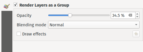
Această funcționalitate a fost finanțată de Andrew Fletcher.
Această funcționalitate a fost dezvoltată de Nyall Dawson
Feature: Support for „Line pattern” when converting Mapbox GL vector tile layer styles
Making use of the brand new raster line symbol layer, QGIS 3.24 now properly renders Mapbox GL line pattern styling for newly-added vector tile layers.
Această funcționalitate a fost dezvoltată de Mathieu Pellerin
Feature: Support background styles for Mapbox GL-styled vector tile layers
We now correctly render any predefined background styling present in Mapbox GL-styled vector tile layers. This dramatically improves the appearance of vector tile layers with dark styles!
Această funcționalitate a fost dezvoltată de Mathieu Pellerin
Caracteristici 3D
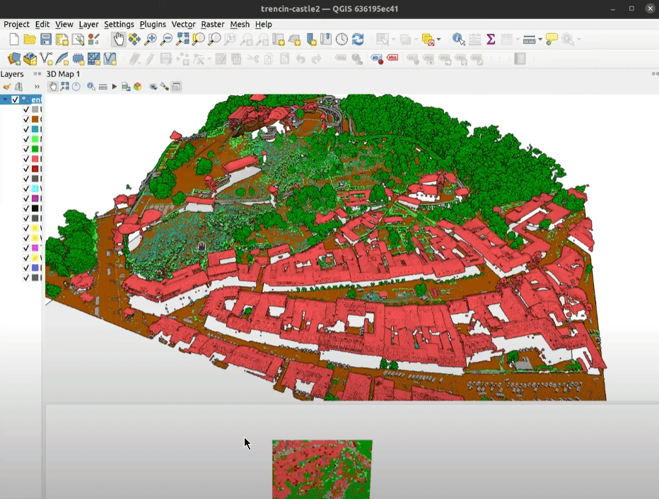
Feature: Respect Z ordering when rendering point clouds in 2D
We’ve added an option to render point clouds according to their Z-order in 2D map views. With the new bottom-to-top ordering option enabled, points with larger Z values will cover lower points – resulting in the appearance of a true orthographic photo. There’s also an option for reverse sorting (top-to-bottom), where the scene appears as if viewed from below.
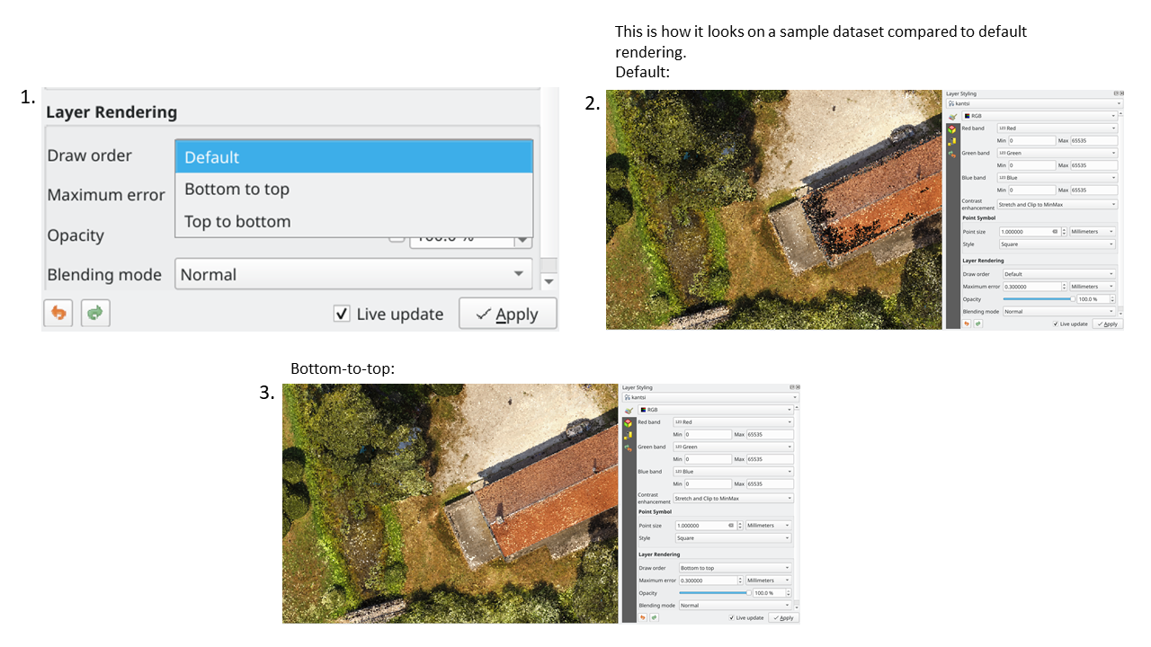
Această funcționalitate a fost finanțată printr-o Strângere de fonduri în scopul îmbunătățirii lucrului cu elevația și norii de puncte în QGIS
Această funcționalitate a fost dezvoltată de Stefanos Natsis (Lutra Consulting)
Feature: Dock/Undock 3D views
We’ve been aware that using dock widgets for 3D maps can be inconvenient, and in many situations these are frustrating to resize and move as they are prone to re-dock as you adjust their sizes! With QGIS 3.24 we added the ability to switch 3D maps from a dockable widget to a top-level window (and back to a dock widget), so that these map views can now be managed, resized and moved just like a standard application window.
Această funcționalitate a fost finanțată printr-o Strângere de fonduri în scopul îmbunătățirii lucrului cu elevația și norii de puncte în QGIS
Această funcționalitate a fost dezvoltată de Nedjima Belgacem (Lutra Consulting)
Feature: 3D map view manager
Previously, if you closed a 3D map view and then saved your project, the 3D map view and all its settings would be lost when you reopen that project. So in QGIS 3.24 we’ve added a „3D map view manager” that takes care of listing, removing, renaming and duplicating 3D map views in your projects!
We’ve also added a new „3D Map Views” menu, which contains all your created 3D map views for easy access!
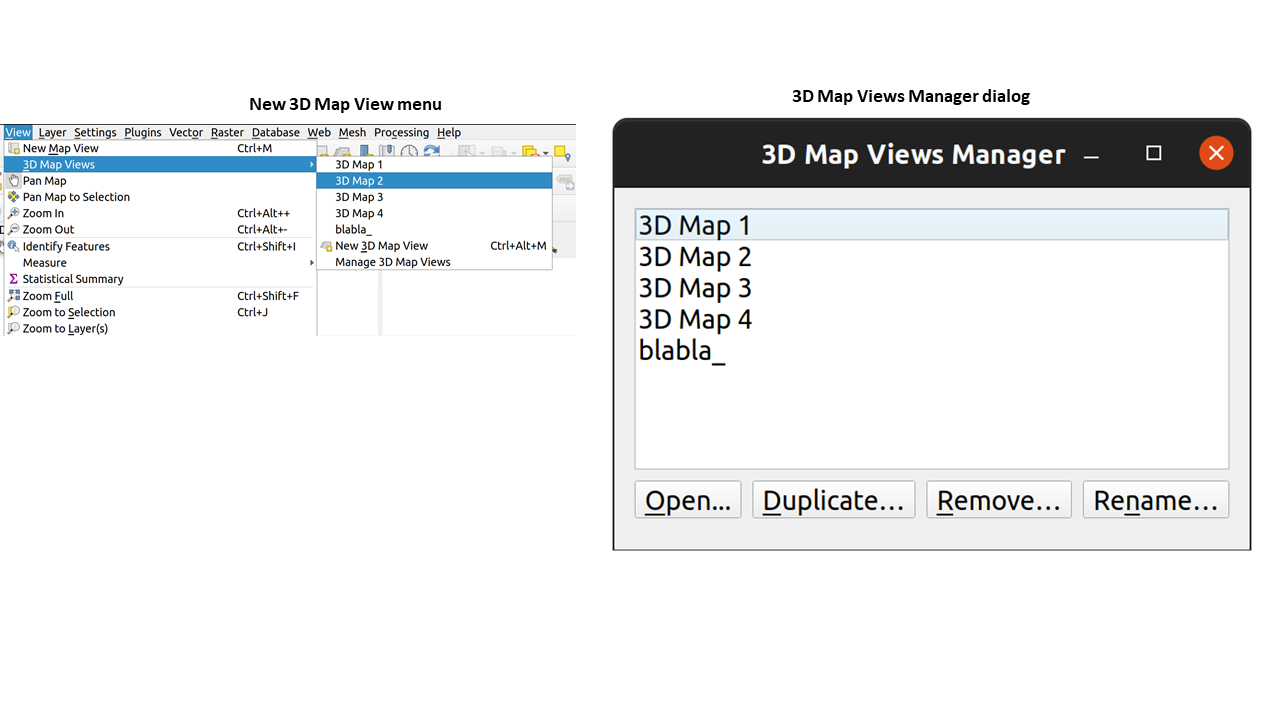
Această funcționalitate a fost finanțată printr-o Strângere de fonduri în scopul îmbunătățirii lucrului cu elevația și norii de puncte în QGIS
Această funcționalitate a fost dezvoltată de Nedjima Belgacem (Lutra Consulting)
Compoziții Cartografice
Feature: Full text rendering capabilities for layout text labels
In older QGIS releases you had to revert to hacky tricks like using HTML and CSS to add effects like drop shadows to text in your map layouts. Hack no more! In 3.24 we now allow you to use the familiar properties from the labeling text options for text on layouts too! This means you can now add shadows, text buffers, backgrounds, letter and word spacing, etc. all on the text items in your layouts.
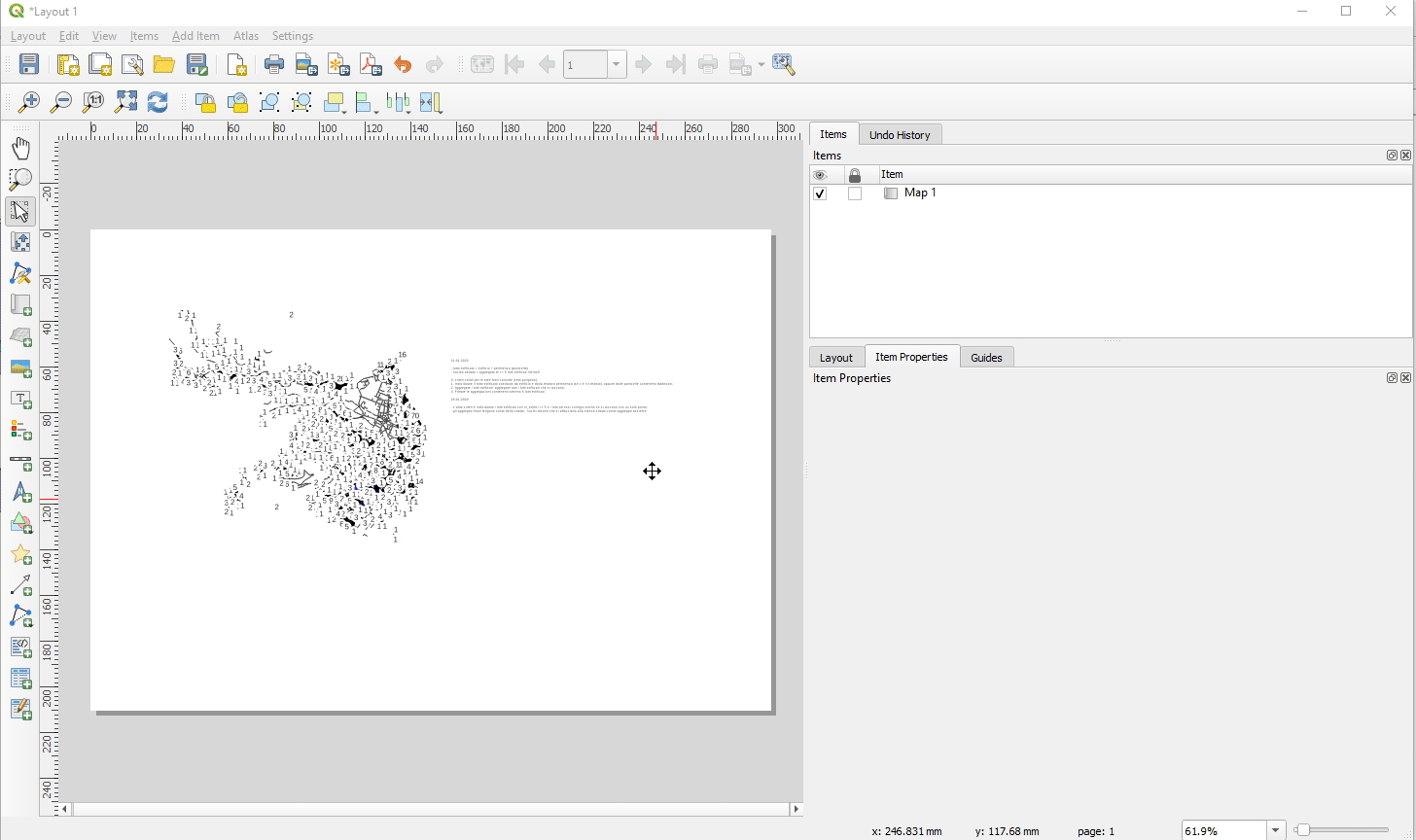
Această funcționalitate a fost finanțată de North Road cu sprijinul SLYR
Această funcționalitate a fost dezvoltată de Nyall Dawson
Expresii
Feature: geometry_type function
The new geometry_type function returns the high-level type of a geometry (i.e. «Point», «Line» or «Polygon»).
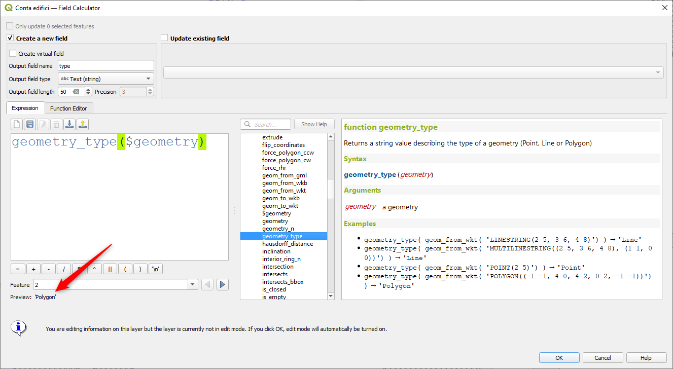
Această funcționalitate a fost finanțată de North Road cu sprijinul SLYR
Această funcționalitate a fost dezvoltată de Nyall Dawson
Feature: Overlay intersects sort by intersection size
We have added further enhancements to the overlay_intersects function. The change adds two new optional arguments to the existing function:
return_details: only valid when used with an expression, set this to true to return a list of maps containing (key names in quotes) the feature «id», the expression «result» and the «overlap» value, the «radius» of the maximum inscribed circle is also returned when the target layer is a polygon.
sort_by_intersection_size: only valid when used with an expression, set this to true to return the results ordered by the overlap value in descending order.
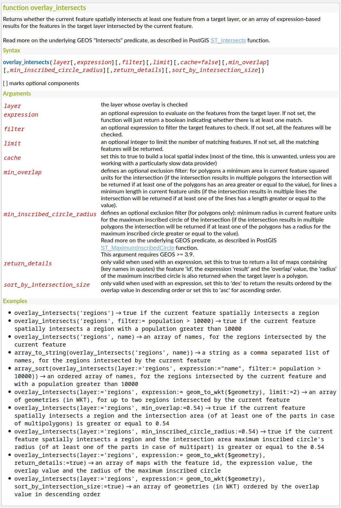
Această funcționalitate a fost finanțată de Kanton Solothurn, Amt für Geoinformation
Această funcționalitate a fost dezvoltată de Alessandro Pasotti
Feature: Show all layer field names when building expressions
As a handy time-saver, we now make a list of all field names from all layers in your project available directly in the expression builder. If you double-click any of these field names, they’ll be added to your expression as string values ('field_name').
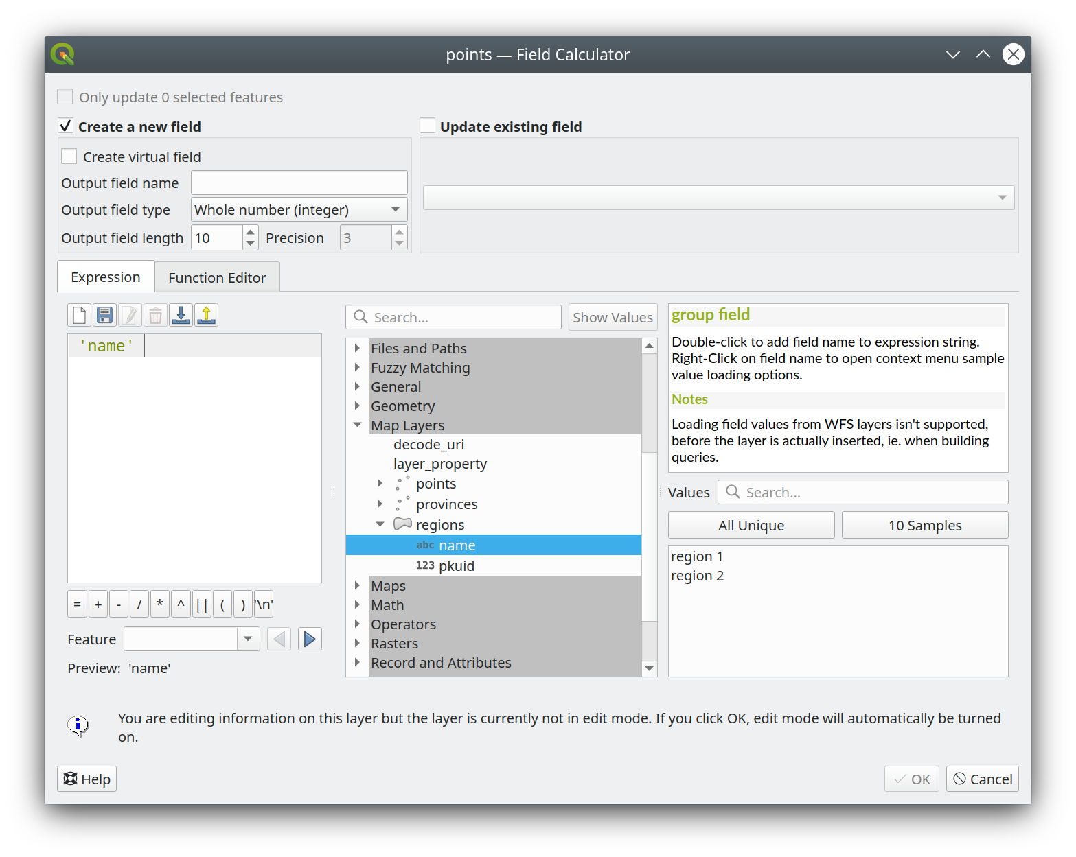
Această funcționalitate a fost finanțată de ARPA Piemonte
Această funcționalitate a fost dezvoltată de Alessandro Pasotti
Feature: represent_attributes function
This new function returns a map with all attribute (field) names as the keys and the configured representation values as values. The representation value for the attributes depends on the configured widget type for each attribute.
The function can be used with zero, one, or more arguments:
If called with no parameters, the function will return the representation of the attributes of the current feature in the current layer.
Dacă este apelată doar cu un parametru «entitate», funcția va returna reprezentarea atributelor entității specificate din stratul curent.
Dacă este apelată cu un parametru «strat» și «funcție», funcția va returna reprezentarea atributelor entității specificate din stratul specificat.
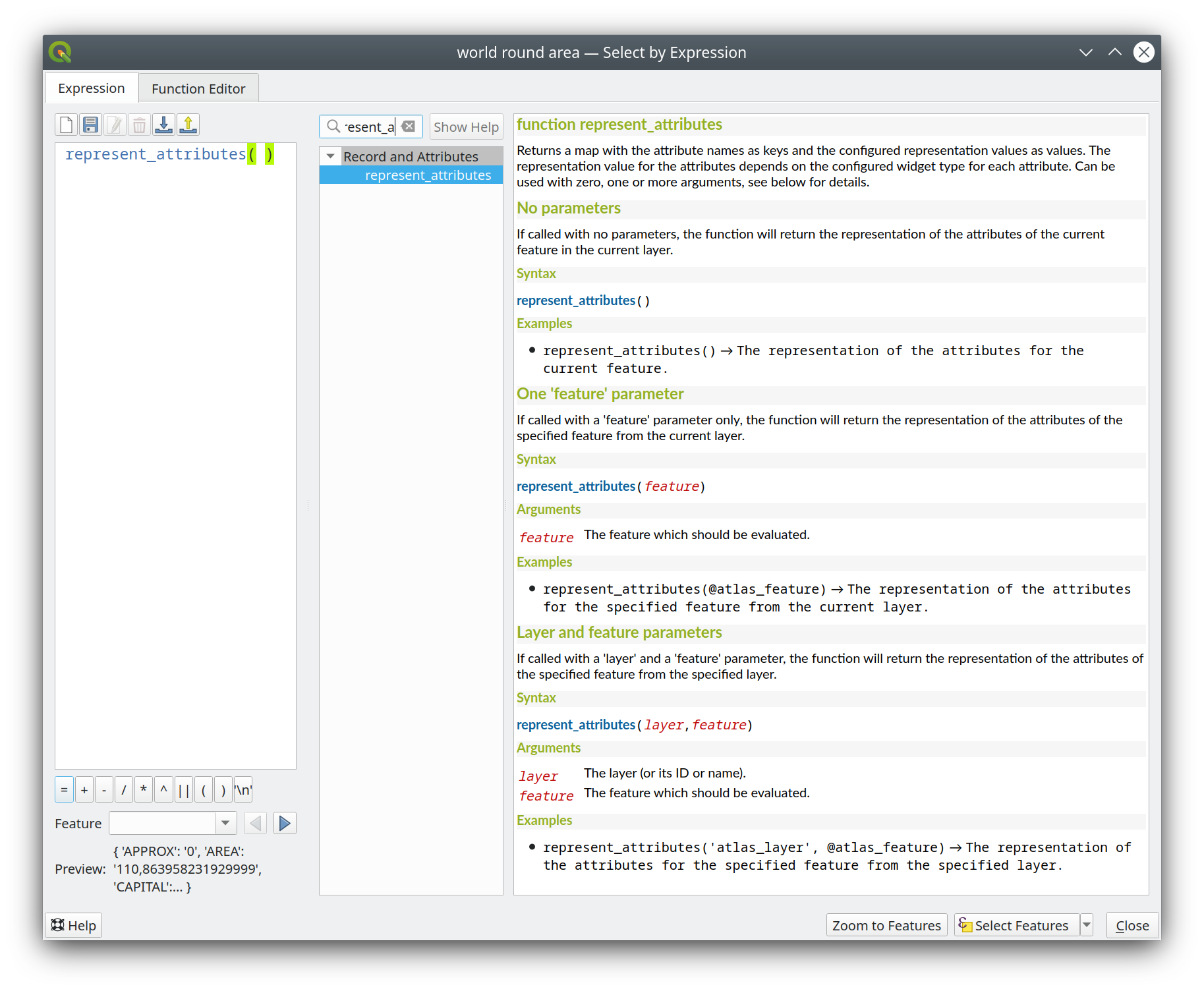
Această funcționalitate a fost finanțată de Cantonul Solothurn
Această funcționalitate a fost dezvoltată de Alessandro Pasotti
Feature: Optional minimum overlap area and circle radius for overlay_intersection
We have added two optional arguments to the overlay_intersection() expression function:
min_overlap: for polygons an optional minimum area in current feature squared units for the intersection (if the intersection results in multiple polygons the intersection will be returned if at least one of the polygons has an area greater or equal to the value), for lines an optional minimum length in current feature units (if the intersection results in multiple lines the intersection will be returned if at least one of the lines has a length greater or equal to the value)min_inscribed_circle_radius: for polygons only an optional minimum radius in current feature units for the maximum inscribed circle of the intersection (if the intersection results in multiple polygons the intersection will be returned if at least one of the polygons has a radius for the maximum inscribed circle greater or equal to the value). Read more on the underlying GEOS predicate, as described in PostGIS ST_MaximumInscribedCircle function.
Această funcționalitate a fost finanțată de Cantonul Solothurn
Această funcționalitate a fost dezvoltată de Alessandro Pasotti
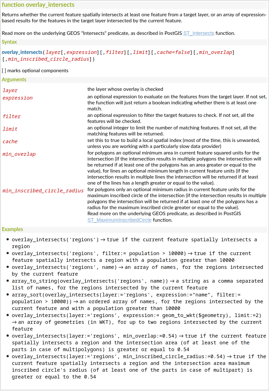
Feature: map_prefix_keys function
In QGIS 3.24 we’ve added a new map_prefix_keys function that takes a map and a prefix, the function returns a map with all keys prefixed by the prefix.
Exemplu: map_prefix_keys(map('1','one','2','two'), 'prefix-')
returnează: { 'prefix-1': 'one', 'prefix-2': 'two' }
Această funcționalitate a fost finanțată de Cantonul Solothurn
Această funcționalitate a fost dezvoltată de Alessandro Pasotti
Feature: densify_by_count and densify_by_distance functions
This functionality, which was previously only available through the Processing toolbox, is now available for use in expressions!
Această funcționalitate a fost finanțată de North Road cu sprijinul SLYR
Această funcționalitate a fost dezvoltată de Nyall Dawson
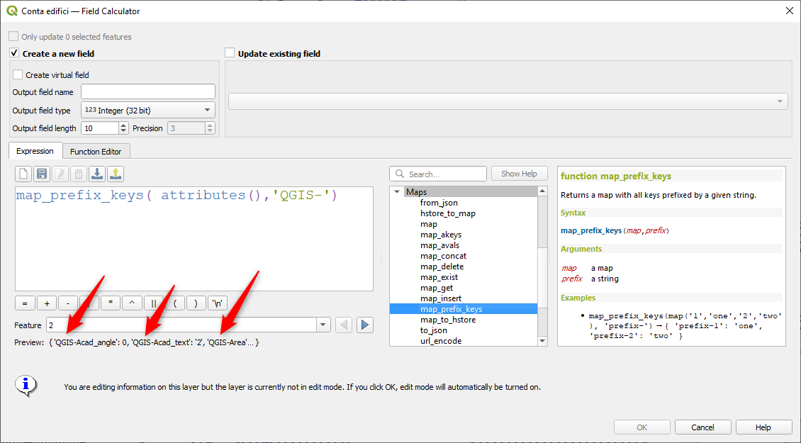
Feature: Rotate parts of multi-part geometries independently with „rotate” expression function
The new „per_part” option for the „rotate” expression function allows you to rotate each part of a multi-part geometry around the center of each part (instead of the center of the geometry as a whole). This enhancement is designed to help out symbology when the rotate function is used as a cartographic tool as part of a geometry generator symbol layer.
Această funcționalitate a fost finanțată de North Road cu sprijinul SLYR
Această funcționalitate a fost dezvoltată de Nyall Dawson
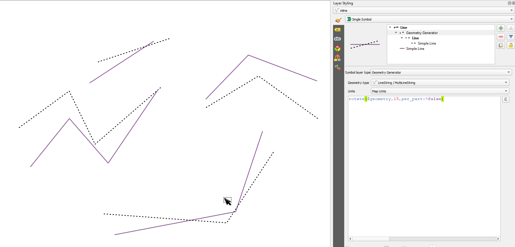
Feature: apply_dash_pattern function
This exciting new expression function applies a dash pattern to a geometry, returning a MultiLineString geometry which is the input geometry stroked along each line (or ring) using a dashed line pattern.
Rules can be set to control how the dash pattern is adjusted at line endings. If you specify a start rule or end rule, then the „adjustment” option defines whether both dash and gaps, or only dash or gap sizes are adjusted to apply these rules.
You can also set an optional pattern offset to specify how far along the pattern the result should start at.
Această funcționalitate a fost finanțată de North Road cu sprijinul SLYR
Această funcționalitate a fost dezvoltată de Nyall Dawson
Feature: scale function
This new expression function allows you to scale (resize) a geometry. Just like the «rotate» function, the function accepts an optional point position to apply the scaling from. If no anchor point is not specified then scaling is done from the center of the geometry’s bounding box.
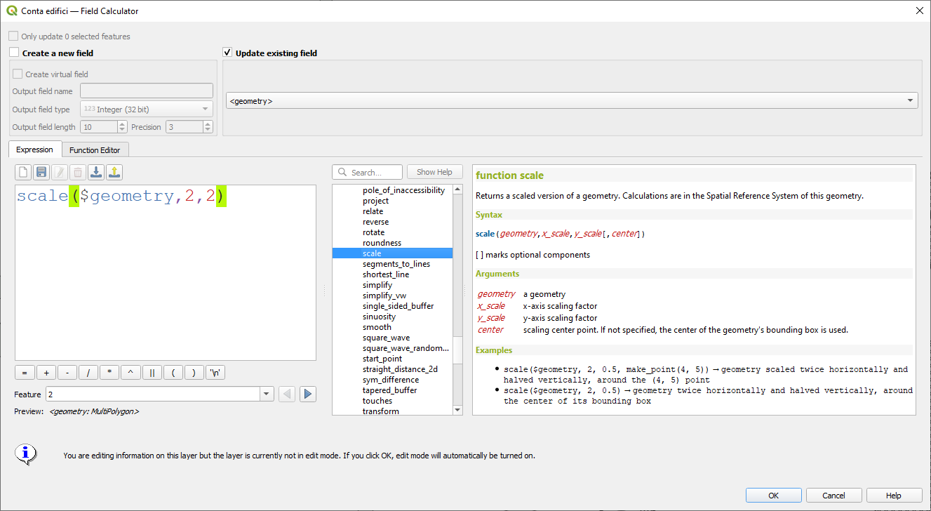
Această funcționalitate a fost finanțată de North Road cu sprijinul SLYR
Această funcționalitate a fost dezvoltată de Nyall Dawson
Feature: Filter by multiple attributes for get_feature function
We extended the get_feature function to allow multi-attribute filtering, by adding an option to pass an array of filter values to the input.
Această funcționalitate a fost dezvoltată de Alex
Gestiunea Datelor
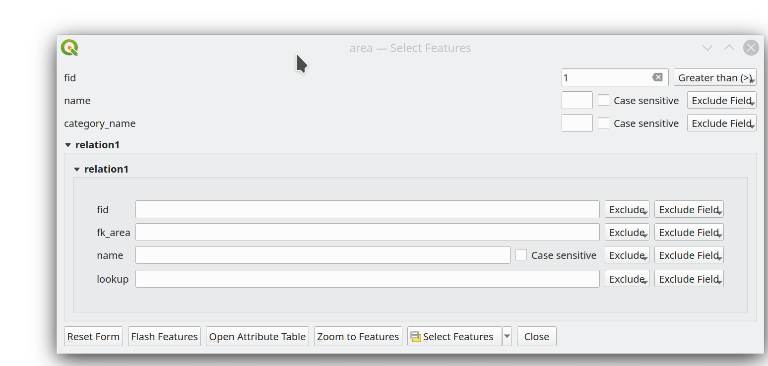
Feature: Multiedit support for relation editor
We’ve added a new multi edit mode for the relation editor, which allows the rapid addition of child features to multiple parent features. This improves efficiency for data management operations, such as the ability to select multiple trees and adding a maintenance item to all of them in one click.
Această funcționalitate a fost finanțată de QGIS Model Baker
Această funcționalitate a fost dezvoltată de Damiano Lombardi, OPENGIS.ch
Metadate și Metacăutare
Feature: Support for OGC API - Records in MetaSearch
We updated the MetaSearch tool to provide support for the OGC API - Records (OARec) standard. As part of the OGC API evolution, OGC API - Records is the successor to OGC:CSW (like OGC API - Features is to WFS, etc.).
The OGC API - Records standard is currently in development and the current timeline for a public RFC by OGC is Q1 2022. This we ask you to take note of the draft status of the specification so you are aware that the specification may change a bit more over the next few months. We still need to flesh out how actionable links are handled over the next few months (which should be a significant improvement compared to the CSW publish/find/bind workflow).
Adding this feature to QGIS is a huge win for easier search and will help both users and providers for the long term.
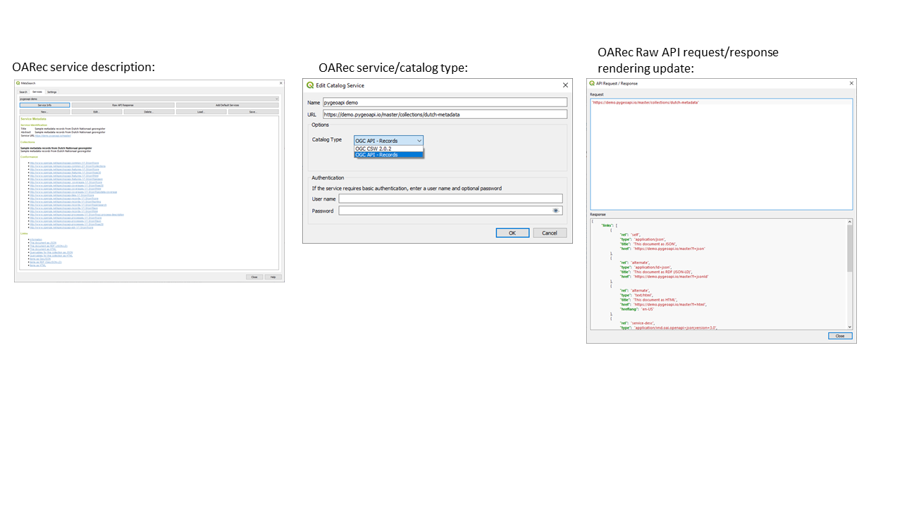
Această funcționalitate a fost dezvoltată de Tom Kralidis
Formulare și Controale grafice
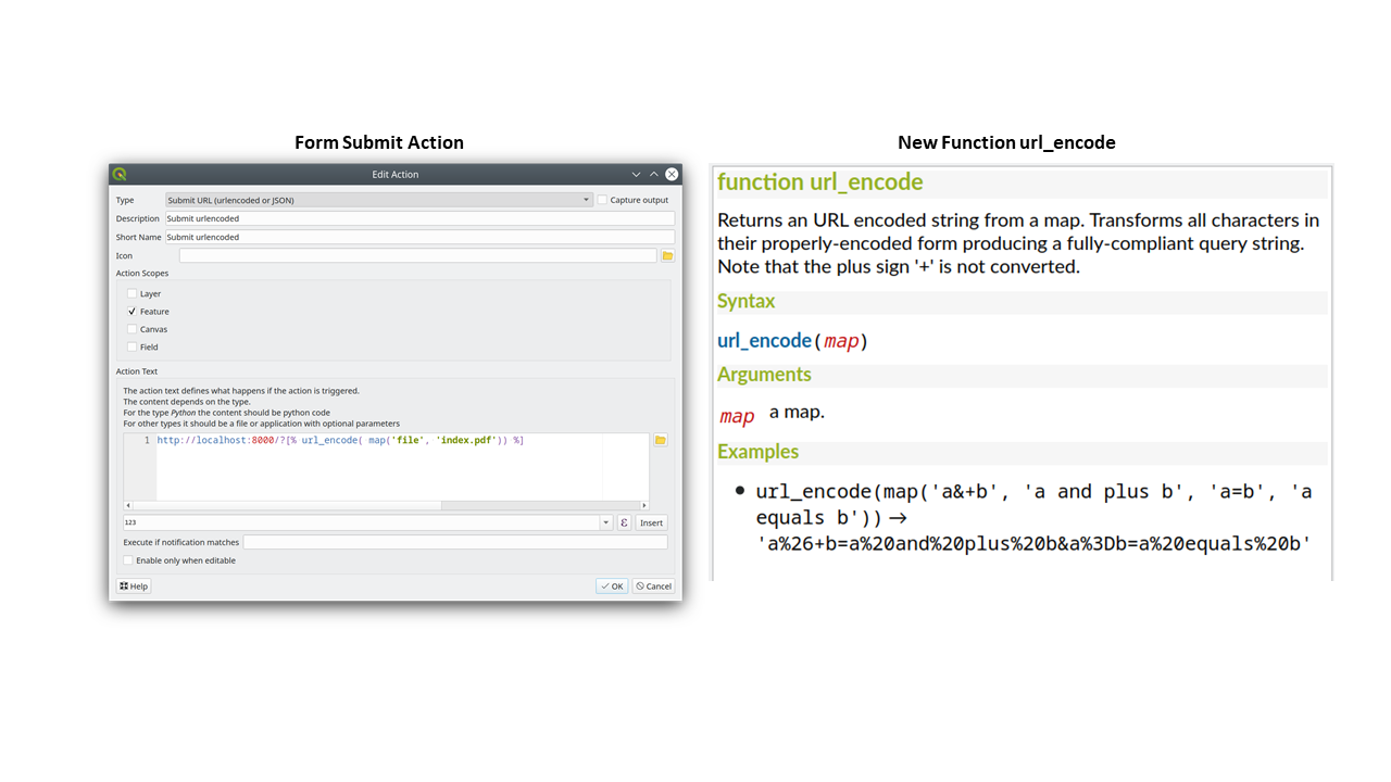
Feature: Form submit actions with HTTP POST
In QGIS 3.24 we added two new HTTP POST actions, similar to the existing Open action which uses an HTTP GET request.
The two actions differ in the way the form data are encoded:
application/x-www-form-urlencoded
multipart/form-data
In both cases, data are passed to the action in a URL encoded URL.
A new function url_encode(<map>) is provided to convert a dictionary (a map) to the encoded format.
The response from the submitted URL is opened by delegating to the operating system QDesktopServices::openUrl() after the payload has been stored in a temporary file.
Această funcționalitate a fost finanțată de Cantonul Solothurn
Această funcționalitate a fost dezvoltată de Alessandro Pasotti
Feature: New button to open attribute table on filtered features
We’ve added a new button to the attribute form (when in search mode) which enables you to open an attribute table filtered to only show the matching features.
Această funcționalitate a fost finanțată de ARPA Piemonte
Această funcționalitate a fost dezvoltată de Alessandro Pasotti
Instrumentele de Analiză
Feature: Add roundness method to curve polygon
We added a „roundness” method to QgsCurvePolygon, allowing the calculation of the „roundness” of an area feature based on the formula Roundness = (4 * pi * Area) / Perimeter^2.
This includes the addition of a new expression and a processing tool for calculating roundness. The processing tool creates a new layer with the roundness of each feature in a new field.
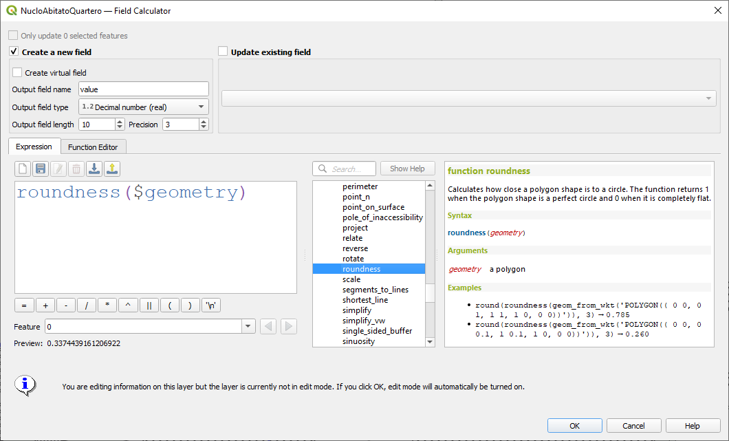
Această funcționalitate a fost dezvoltată de Antoine Facchini
Processing
Feature: Extract labels algorithm
For 3.24 we added a new tool to QGIS» processing toolbox: „Extract labels”. As its name hints at, this algorithm extracts label information from a rendered map at a specific extent and scale.
Extracted label information include its position (as point geometries), the associated layer name and feature ID, as well as label appearance properties such as rotation, text, alignment, font family, size, weight, etc.
The algorithm also generates a default symbol-less & labelled style for the output layer which allows for those saved layers to be drag and dropped into projects and have the label drawn exactly as they were exported.
If a map theme is specified when extracting labels, the exported labels will match the visibility and symbology of that theme. If left blank, the project’s current visible layers will be used.
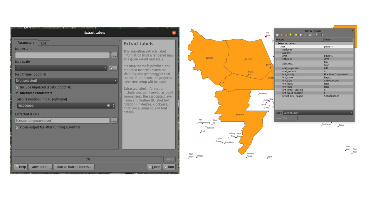
Această funcționalitate a fost finanțată de TEKSI
Această funcționalitate a fost dezvoltată de Mathieu Pellerin
Feature: Optional output extent parameter for the GDAL Raster Calculator algorithm
When running against GDAL 3.3 or newer, QGIS processing toolbox’s GDAL Raster Calculator algorithm now allows you to specify an optional „output extent” parameter. This can be quite useful when working with large datasets, often avoiding the need to create an intermediary clipped raster prior to running the calculator algorithm.
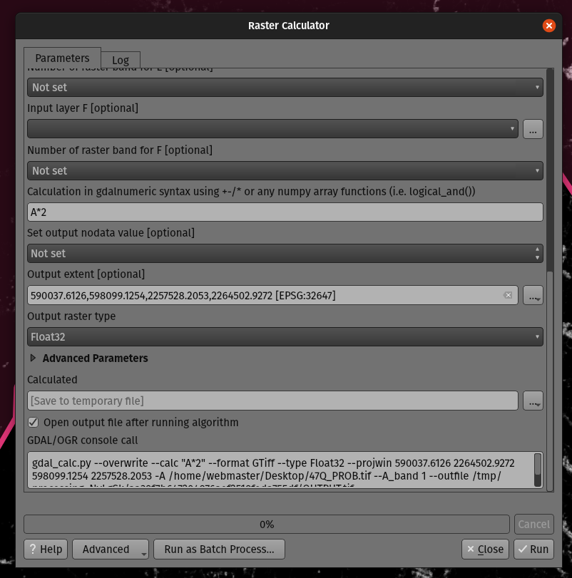
Această funcționalitate a fost dezvoltată de Mathieu Pellerin
Feature: Optional extent parameter for the GDAL clip raster by mask algorithm
We added an optional extent parameter to the GDAL „clip raster by mask” algorithm, which can come in handy when working with large raster datasets.
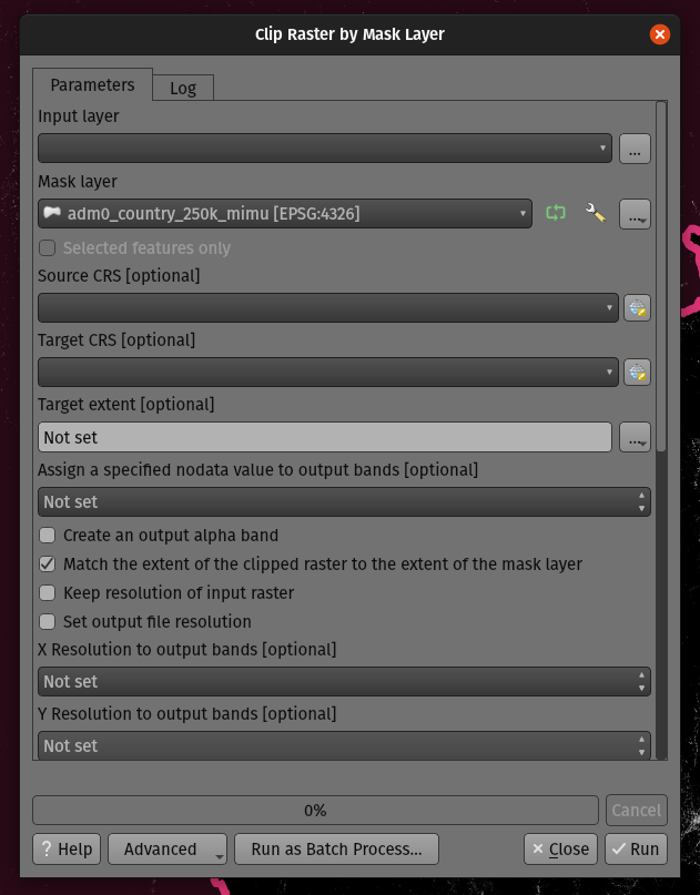
Această funcționalitate a fost dezvoltată de Mathieu Pellerin
Feature: Processing history rework
QGIS 3.24 includes a partial implementation of the framework described in QEP 130, and ports the Processing history log over to this framework.
This is a much more flexible approach to storing Processing history, as it allows us to store unlimited additional information about the executed tool (including all the input parameters, output results, and the full text log too!). The history log is now stored in a sqlite database instead of the text file previously used, which allows for more efficient storage/retrieval/filtering.
The new framework potentially extends to more than just Processing - it could also be used to store the history of other user operations, such as project edits, layout exports etc!
We’ll be using this framework in future to further extend the Processing history dialog. For 3.24, we’re using it to expose a number of helpful additions to the history dialog:
Right clicking an entry in the log has a new option to copy the execution parameters as a „qgis_process” command line equivalent, giving you a super-easy way to generate qgis_process commands for execution in a CLI.
Right clicking an entry also shows a new „Copy as JSON” option, which copies a JSON string of the input parameters and algorithm settings
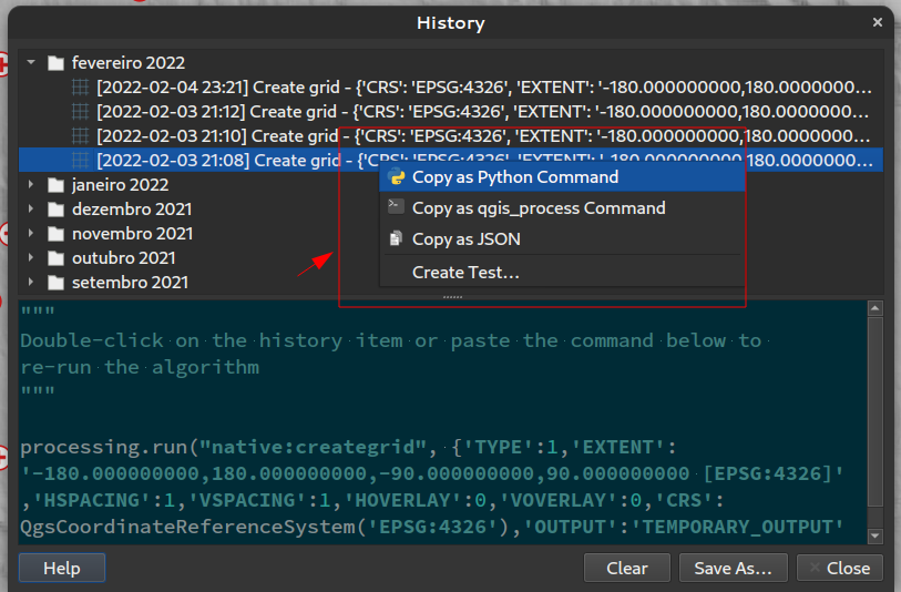
Această funcționalitate a fost finanțată de Institutul de Cercetare pentru Natură și Pădure, al Guvernului Flamand
Această funcționalitate a fost dezvoltată de Nyall Dawson
Feature: Advanced actions in Processing dialogs
We have added new actions on the processing dialog including copy as qgis_process command, and copy/paste as JSON. Together these actions:
Allows for easy copying of the equivalent PyQGIS command to run the tool using the parameters defined in the dialog
Allow for easy generation of qgis_process commands via the QGIS GUI, including any tricky parameter values like GeoPackage outputs with specific layers
Provide a way for you to copy the settings defined in the dialog in a text format, so that you can store these easily and then restore them later by pasting the values.
Provides an easy way for you to copy the settings into the JSON format consumed by qgis_process, so that it is easy to see the expected format even for complex parameters (like TIN interpolation parameters).
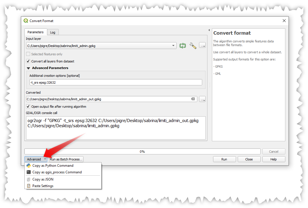
Această funcționalitate a fost finanțată de Institutul de Cercetare pentru Natură și Pădure, al Guvernului Flamand
Această funcționalitate a fost dezvoltată de Nyall Dawson
Feature: Single file exports from Atlas to PDF algorithm
You can now export an atlas layout to a single (collated) PDF file using the „Export atlas layout as PDF” processing algorithm.
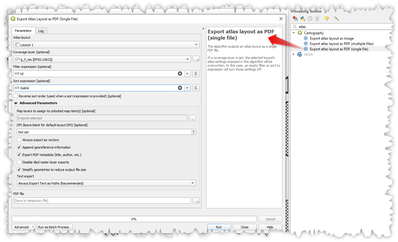
Această funcționalitate a fost dezvoltată de Nyall Dawson
Feature: Project Models are shown in the Project menu
We added a new submenu to the „Project” menu, which will list any Processing models stored within the current project. This gives you a quick way to launch these project-specific models, in either a single or batch mode!
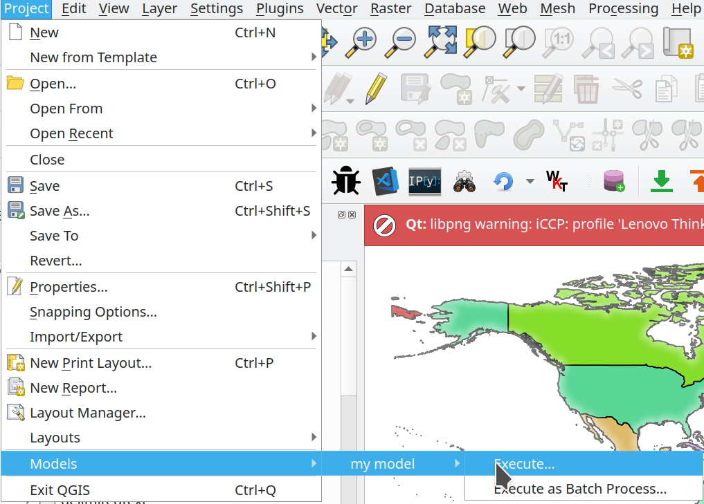
Această funcționalitate a fost finanțată de Cantonul Solothurn
Această funcționalitate a fost dezvoltată de Alessandro Pasotti
Feature: Add point cloud destination parameter and output to Processing
We have extended and improved point cloud support in Processing, namely by:
Fixing the filtering of point cloud layers in
QgsProcessingMapLayerComboBox-based widget used for parametersAdding a destination point cloud parameter type and point cloud output types with corresponding widgets. (Currently these are useful for 3rd party providers and plugins which create point cloud outputs.)
Exposing the newly added point cloud output and destination parameters to the
algfactorywrapper
Această funcționalitate a fost dezvoltată de Alexander Bruy
Feature: Array field support
In QGIS 3.24, we’ve made array field types first-class citizen in the Processing toolbox! The following algorithms have all been updated to support array fields:
Refactor algorithm;
Algoritm de agregare;
Add field to attributes table algorithm;
Field calculator algorithm; and
Advanced (i.e. python) field calculator algorithm
Această funcționalitate a fost finanțată de SwissTierras Colombia
Această funcționalitate a fost dezvoltată de Mathieu Pellerin
Opțiunile Aplicației și ale Proiectului
Feature: qgis_process –no-python argument
This new, optional command line parameter for the qgis_process command-line tool allows you to skip launching Processing with Python support when it is not required. This can result in a significant improvement in qgis_process startup times!
Această funcționalitate a fost finanțată de North Road
Această funcționalitate a fost dezvoltată de Nyall Dawson
Feature: Suppress „bad layers” handler on startup
We’ve added support for a new command line flag for the qgis executable, which allows you to disable the default dialog which shows when opening a project with missing/broken layers:
[--skipbadlayers] don't prompt for missing layers
Example invocation: ./qgis --skipbadlayers or ./qgis -B
The use case for this is that sometimes users have automation or other post-startup processes happen and do not want to have the startup process interrupted if there are bad layers present in the project. After startup, QGIS will ignore any missing layers, but they will still be marked as broken in the layers list.
Această funcționalitate a fost sugerată și codificată în direct de către Giuseppe Baiamonte, în cadrul QGIS Open Day din 17 decembrie 2021.
Această funcționalitate a fost finanțată de Tim Sutton
Feature: Parameter values for qgis_process can be specified as a JSON object via stdin
We now provide a mechanism to support complex input parameters for algorithms when running the qgis_process command line tool.
To indicate that parameters will be specified via stdin then the qgis_process command must follow the format
qgis_process run algid -
(with a trailing - in place of the usual arguments list).
The JSON object must contain an „inputs” key, which is a map of the input parameter values.
echo "{"inputs": {\"INPUT\": \"my_shape.shp\", DISTANCE: 5}}" | qgis_process run native:buffer -
Additionally, extra settings like the distance units, area units, ellipsoid and project path can be included in this JSON object:
{
    'ellipsoid': 'EPSG:7019',
    'distance_units': 'feet',
    'area_units': 'ha',
    'project_path': 'c:/temp/my_project.qgs'
    'inputs': {'DISTANCE': 5, ..... }
}
(Specifying input parameters via stdin implies automatically the –json output format for results.)
One big motivation behind this enhancement is to provide a way for the qgis_process R libraries to support parameter types such as aggregates!
Această funcționalitate a fost finanțată de Institutul de Cercetare pentru Natură și Pădure, al Guvernului Flamand
Această funcționalitate a fost dezvoltată de Nyall Dawson
Feature: Run Python script algorithms directly via qgis_process
The qgis_process command-line tool now supports running a Python script algorithm directly by specifying the path to the .py file, in place of an algorithm ID or model file path!
Această funcționalitate a fost dezvoltată de Nyall Dawson
Furnizorii de Date
Feature: Friendlier errors from XYZ raster tiles, WMS and vector tiles
Server errors which occur during XYZ, vector tile or WMS network requests are now shown directly in the QGIS window via the message bar. We’ve made these error messages much more descriptive and helpful, by including the original response error text wherever possible!
Această funcționalitate a fost finanțată de MapTiler
Această funcționalitate a fost dezvoltată de Lutra Consulting (Vincent Cloarec)
Feature: Add out-of-the-box connection to Mapzen Global Terrain tiles
QGIS now sports built-in support for the Terrarium DEM format for WMS/XYZ layers. In addition, we now have out-of-the-box ability to add Mapzen Global Terrain Tiles hosted on AWS. You can find the new MapZen option in the XYZ section of the browser panel. Users now have an immediately accessible global DEM source for their projects!! See also https://registry.opendata.aws/terrain-tiles/
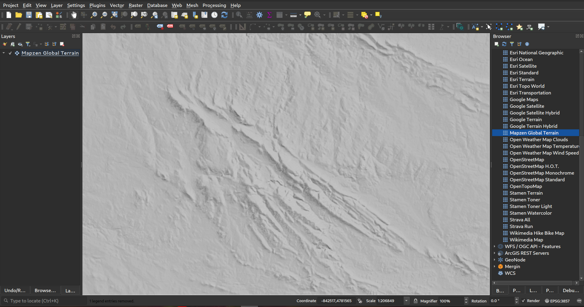
Această funcționalitate a fost dezvoltată de Nyall Dawson
Feature: HMAC SHA256 auth method for MapTiler
We’ve added a new authentication method specific for MapTiler which allows you to use a token encrypted with HMAC-SHA256.
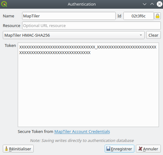
Această funcționalitate a fost finanțată de MapTiler
Această funcționalitate a fost dezvoltată de Lutra Consulting (Vincent Cloarec)
Feature: Template parameter {usage} for XYZ raster and vector tiles
For XYZ tile-based raster layers and for vector tile layers, we now allow the possibility to insert {usage} template parameters (in addition to {x}, {y}, {z}). If present, this parameter will be replaced by the context in which the request is being made.
The possible context values are:
view - when the request comes from 2D or 3D map canvas
export - when the request comes from exporting a layer or exporting a print layout for high-quality output (map previews in print layout designer are classed as “view”)
unknown - when coming from some other context, but the source is unknown
This functionality is useful for MapTiler clients, where they need to recognize the context in which tiles are used in order to bill users accordingly.
Această funcționalitate a fost finanțată de MapTiler
Această funcționalitate a fost dezvoltată de Lutra Consulting (Vincent Cloarec)
Feature: Convert WMTS/XYZ raster tiles to terrain (DEM)
In QGIS 3.24 we’ve introduced the possibility to convert WMTS/XYZ raster datasets to a raster layer of single band float type following a predefined encoding scheme.
You can activate this option and choose an encoding scheme (for now, „MapTiler Terrain RGB” or „Terrarium Terrain RGB” are available) in the source settings of the XYZ connection or in the Data Source Manager when adding a WMST layer.
The selected converter will translate the RGB source values to float values for each pixel. After loading, the layer will be presented as a single band floating point raster layer, ready for styling using a pseudocolor or hill shade renderer!
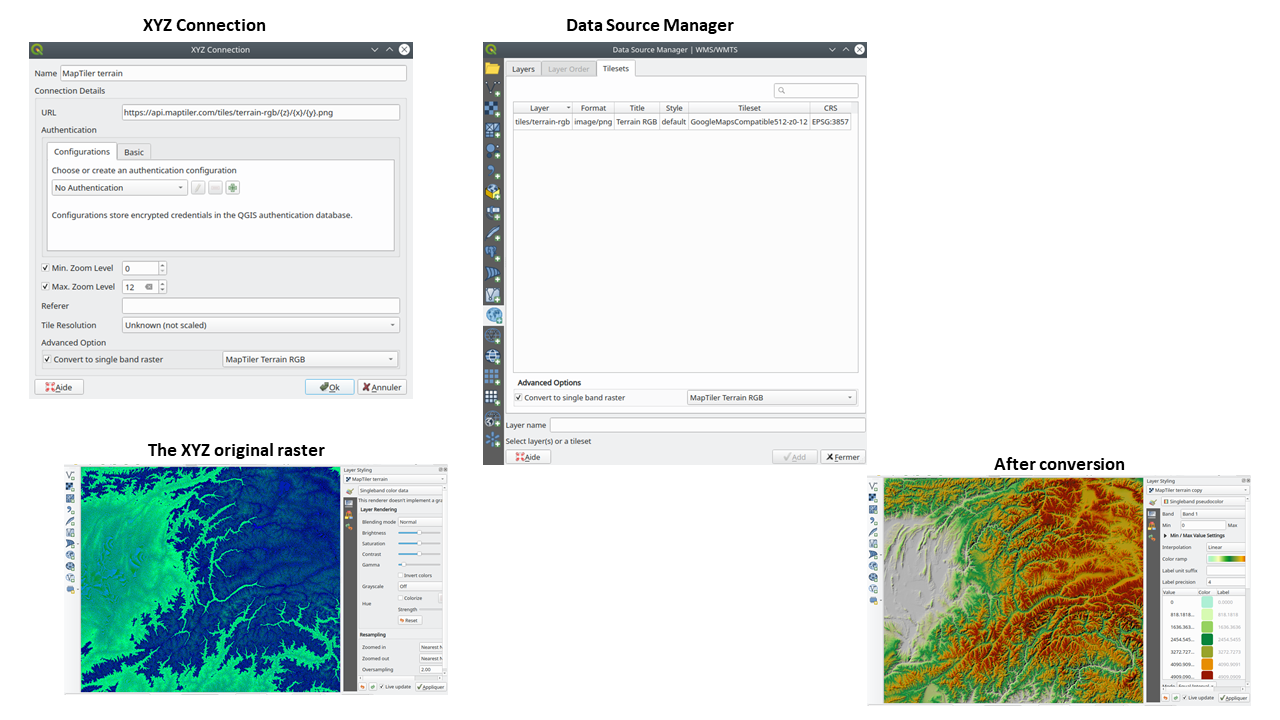
Această funcționalitate a fost finanțată de MapTiler
Această funcționalitate a fost dezvoltată de Lutra Consulting (Vincent Cloarec)
Feature: Array field types for scratch layers
You can now add array field types directly to newly created scratch layers. (While array field types have previously been supported by scratch layers, there was no way for users to add them when creating a new scratch layer.)
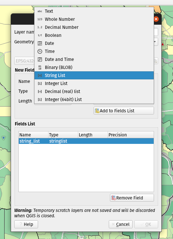
Această funcționalitate a fost dezvoltată de Mathieu Pellerin
Feature: JSON field types for new GeoPackage layers
We’ve added support for creating JSON fields directly to newly created GeoPackage layers. (While JSON field types have previously been supported by GeoPackage layers, there was no way for users to add them when creating a new layer.)
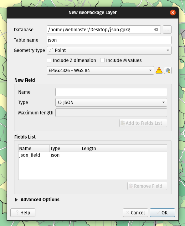
Această funcționalitate a fost dezvoltată de Mathieu Pellerin
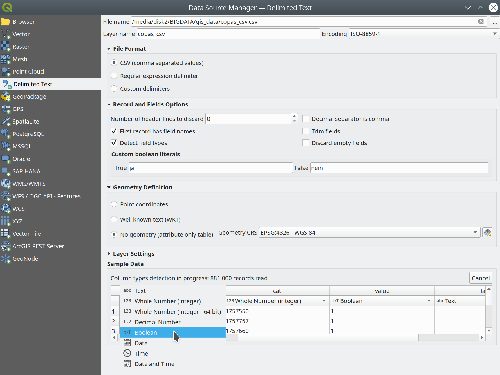
Feature: Delimited text type overrides and other improvements
We’ve given some love to the delimited text data provider in 3.24, with several enhancements which include:
Boolean type support and automatic detection
Boolean data types are now first-class citizens, which are automatically recognized when all records in a column contain one of the following values (case insensitive):
t/f
true/false
yes/no
0/1
Boolean fields are also detected from a CSVT file, a GDAL/GeoCSV format e.g.
Integer(Boolean)
You can also add custom string representations for TRUE/FALSE (for example a localized „yes”/”no” value).
Column type override
Column types are automatically determined (by an initial limited scan of the file for immediate feedback followed by a full scan of the file which happens in a separate thread to not block the GUI and is user-interruptible), the types are exposed to the GUI as combo boxes and the user can override the automatically determined types.
Enhanced CSVT support.
CoordX, CoordY, Point(X/Y), WKT are now recognized as specified in https://giswiki.hsr.ch/GeoCSV
Această funcționalitate a fost finanțată de Stadt Freiburg im Breisgau
Această funcționalitate a fost dezvoltată de Alessandro Pasotti
Feature: New authentication method for HTTP header based authentication
A new authentication method is available for network requests which that supports user defined HTTP header authentication. Multiple custom headers can be included in these requests.
This is useful in various scenarios, such as when a WMS requires an API key that is to be used in a HTTP header with the header key being X-API-KEY, which can now be included in requests from QGIS to authenticate against the WMS endpoint.
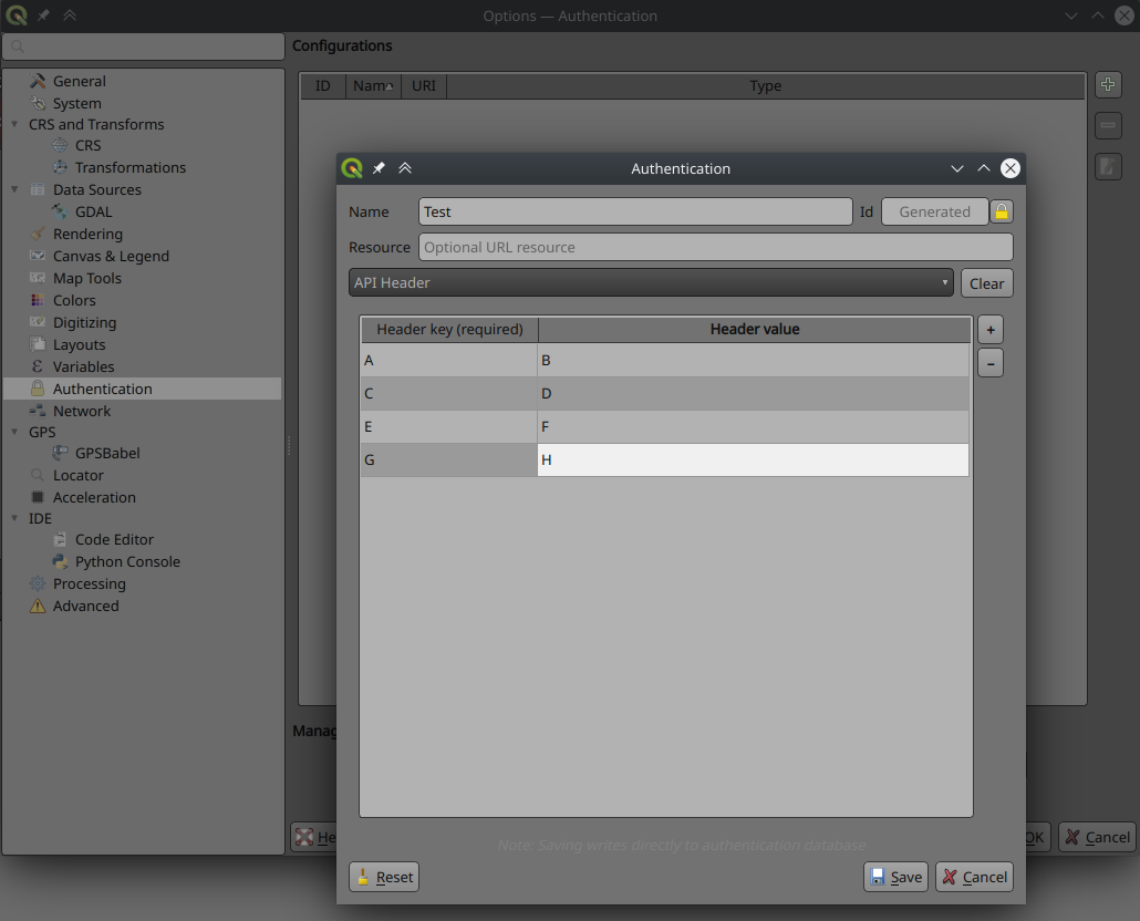
Această funcționalitate a fost finanțată de Tom C
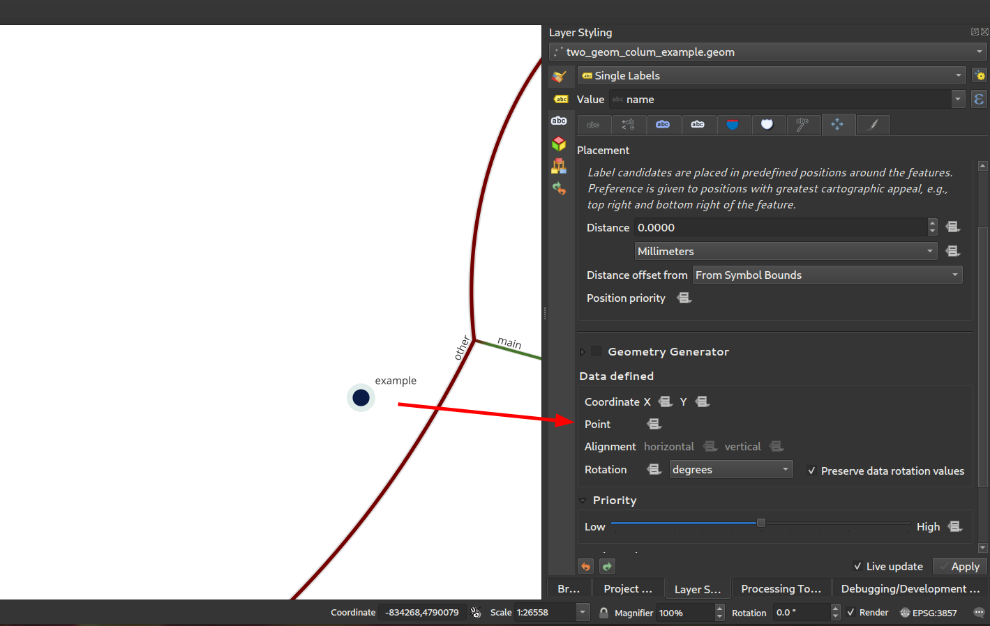
Feature: Expose secondary PostGIS geometry columns as referenced geometries
As discussed in this issue, we have added support for exposing additional geometry columns from the Postgres provider as QgsReferencedGeometry. This allows more efficient interaction with additional geometry columns through the API. For example, in label placement, the additional geometry column can be used instead of the feature geometry. The fields will be represented as WKT [CRS User-Friendly Identifier] in the attribute table.
This can be used in expressions and in the label placement properties tab where you can link the label placement to the second geometry column using the Point property. In the case where you using it for labelling, the second geometry column will be updated automatically if you use the move tool and the columnt type is Geometry. If the column type is text, you could also use that as a second geometry by doing e.g.
geom_from_wkt("my wkt string field")
In this case however, the column will be read only.
So e.g. now in expressions if you have secondary geometry column you can do:
buffer("my_second_geom_column", 10)
and it will work.
Atenționare
This changes the behavior of existing projects.
Această funcționalitate a fost finanțată de OPENGIS.ch
Această funcționalitate a fost dezvoltată de Matthias Kuhn, OPENGIS.ch
QGIS Server
Feature: Allow better control of the response flow chain from server filters
New filters allow control of the call chain by implementing new filter callbacks that allow returning a control value for stopping propagation. This allows for the better control of streamed data and response flow.
Au devenit învechite
bool QgsFilter::onRequestReady(),bool QgsFilter::onSendResponse(),bool QgsFilter::onResponseComplete()Add new methods
bool QgsFilter::onRequestReady(),bool QgsFilter::onSendResponse(),bool QgsFilter::onResponseComplete()which return boolean values for controlling data flowHandle flow control in
QgsFilterResponseDecorator::flush()
Această funcționalitate a fost dezvoltată de David Marteau
Corecții Importante
Corecții efectuate de Alessandro Pasotti
Titlul Erorii |
URL issues.qgis.org (dacă a fost raportată) |
URL Commit (Github) |
3.22 backport commit (GitHub) |
|---|---|---|---|
Wrong raster projection on HIDPI screens |
DE EFECTUAT |
||
Data Source Manager title not translatable |
DE EFECTUAT |
||
QGIS 3.22 - Identical map names in print composer |
Funcționează pentru mine |
||
Bold and italic attributes of labels that reinitialize |
Funcționează pentru mine |
||
NameError: name «QGISAPP» is not defined when using stop_app() |
Works for me on Linux/master, might be windows only |
||
Virtual layer not loaded correctly after re-opening a project |
DE EFECTUAT |
||
QGIS crashes while calling readLayerXml() |
Funcționează pentru mine |
||
Crash when changing orientation of page in layout |
DE EFECTUAT |
||
„sort” funcionality of attributes table sort numeric fields as text |
DE EFECTUAT |
||
OAPIF: api-key not included when requesting /collections endpoint |
DE EFECTUAT |
||
XML notation if missing from tooltips in vector file writer dialog |
DE EFECTUAT |
||
Ignore out of range option in interpolated symbol renderer creates artifacts if start value is out of range |
DE EFECTUAT |
||
start width > end width is ignored when using the „exact” color interpolation method |
DE EFECTUAT |
||
QGIS Layouts: using „Data defined override” for HTML Source URL not working |
la mine funcționează (închisă - nu este o eroare) |
||
(Un)force hide form in relation widget |
DE EFECTUAT |
||
Oauth2 authentication protocol does not honors the defined port number in redirect URL in QGIS 3.22.1 |
la mine funcționează (rămâne deschisă) |
||
HTML/String-ish QByteArray as result of expression function breaks expression preview display |
DE EFECTUAT |
||
Raster layer exported to GeoPackage with the character «ß» in the name is not immediately loaded in the project |
la mine funcționează (închisă) |
||
Layout Attribute Table sorting does not work in Print Layouts when column name has spaces |
DE EFECTUAT |
||
Incorrect scale range legend after applying logarithmic graduated symbology to a vector layer |
Riscant? |
||
fix server crash |
neraportat |
DE EFECTUAT |
|
Load QGIS project from command line from a PostgreSQL project |
DE EFECTUAT |
||
Aggregate function with filter doesn’t work in layout manager |
Works for me (closed) |
||
Value map widget: „value”/”description” inconsistency when table added to print layouts |
DE EFECTUAT |
||
Missing entries in attributetable in layout with atlas at page break |
DE EFECTUAT |
||
Server OAPIF: bbox filter isn’t working if data source CRS is not EPSG:4326/WGS84 |
DE EFECTUAT |
||
Drag & Drop designer control visibility by expression with field IS NOT NULL doesn’t work if the field is configured with html |
Riscant? |
Această corecție a fost finanțată de QGIS.ORG (prin programul de donații și susțineri)
Erori remediate de Alessandro Pasotti
Corecții efectuate de Sandro Santilli
Titlul Erorii |
URL issues.qgis.org (dacă a fost raportată) |
URL Commit (Github) |
3.22 backport commit (GitHub) |
|---|---|---|---|
DistanceWithin algorithm failing with PostgreSQL provider |
|||
GH_WORKSPACE -> QGIS_WORKSPACE |
|||
Improve documentation about running tests |
|||
Use variables to set postgresql connection config in authmanager test |
|||
Re-use possibly cached postgis_version from pgsql description method |
|||
Trust primary key of layers setup by DBManager TopoViewer plugin |
|||
Improved debugging output in QgsPostgresConn class |
Această corecție a fost finanțată de QGIS.ORG (prin programul de donații și susțineri)
Erori remediate de Sandro Santilli
Corecții efectuate de Even Rouault
Titlul Erorii |
URL issues.qgis.org (dacă a fost raportată) |
URL Commit (Github) |
3.22 backport commit (GitHub) |
|---|---|---|---|
QGIS 3.21.0: preset transform required „nehpgn.gsb” but downloads „nehpgn.tif” which does not work |
|||
Raster layer misaligns when bbox bigger than projected raster layer |
|||
Filter for WFS layer: The „Tables” button is missing |
Nu este o eroare |
||
Something simpler than SQL to filter a WFS layer |
|||
renaming/deleting columns takes a lot of time on large vectors |
|||
Opening a Vector Geopackage in QGIS alters its file even when no changes are done by user |
|||
MapInfo CRS not correctly recognized |
|||
Crash exporting dxf using „Symbol layer symbology” |
Această corecție a fost finanțată de QGIS.ORG (prin programul de donații și susțineri)
Erori remediate de Even Rouault
Corecții efectuate de Denis Rouzaud
Titlul Erorii |
URL issues.qgis.org (dacă a fost raportată) |
URL Commit (Github) |
3.22 backport commit (GitHub) |
|---|---|---|---|
Trying to add GPKG from data source manager crashes QGIS master |
nerelevant |
||
Display name in layer properties is not automatically filled |
|||
Fixes to QgsGeometry::addPart + new test cases |
neraportat |
Această corecție a fost finanțată de QGIS.ORG (prin programul de donații și susțineri)
Erori remediate de Denis Rouzaud
Erori remediate de Alex Bruy
Titlul Erorii |
URL issues.qgis.org (dacă a fost raportată) |
URL Commit (Github) |
3.22 backport commit (GitHub) |
|---|---|---|---|
Layout picture: data-defined svg parameters should be disabled for incompatible pictures |
|||
TypeError in MetaSearch when adding WFS data |
|||
Split Vector Layer algorithm does not export both null and empty values |
|||
data source manager not opening with correct sub menu for point cloud datasources |
|||
SLD import doesn’t recognize html enconding in ttf font references |
|||
Error opening data loader dialog from MetaSearch |
Funcționează pentru mine |
||
Display name in layer properties is not automatically filled |
|||
No way to add mbtiles file-based MVT package except drag and drop |
|||
„GDAL rasterize overwrite with attribute” does not refresh/reload output |
|||
Delete Column in Matrix Parameter in Graphic Modeler not Working |
|||
Wrong signature of the QgsProcessingParameterMeshDatasetGroups when exporting to Python |
neraportat |
||
Error message when GRASS tools cannot be run is (now) wrong |
|||
„Ignore invalid input features” processing setting location is misleading |
|||
Inconsistent number of decimal places in Identify tool |
|||
qgis_process is not showing algorithm providers installed via a python plugin |
|||
Unable to delete files .shp and .dbf using python code (removeMapLayers, deleteShapeFile) |
Funcționează pentru mine |
||
Opțiunea extinsă QgsProcessingParameterFile |
Nu este o eroare |
||
Make the labels „edit rule” widget a real dialog with buttons |
|||
Edit form python editor tabs/spaces confusion |
|||
Error when making buffer from empty layer with «Dissolve result» option checked |
|||
QGIS does not replace commas in layer names when exporting to DXF (so is incompatible with AutoCAD) |
Această corecție a fost finanțată de QGIS.ORG (prin programul de donații și susțineri)
Erori remediate de Alex Bruy
Corecții efectuate de Paul Blottiere
Titlul Erorii |
URL issues.qgis.org (dacă a fost raportată) |
URL Commit (Github) |
3.22 backport commit (GitHub) |
|---|---|---|---|
Fixes WFS EXP_FILTER parsing in GetFeature request |
Prea riscant |
||
Fix output filename when a raster is saved in a format without extension |
neraportat |
DE EFECTUAT |
|
WFS GetFeature document and exceptions |
neraportat |
DE EFECTUAT |
|
Exluding a print layout in project propteries -> server do not avoid that a GetPrint request can be done for that layout |
DE EFECTUAT |
||
Server: Can’t enable WFS3 API update endpoint (PUT/PATCH) on layers without geometry |
Funcționează pentru mine |
Această corecție a fost finanțată de QGIS.ORG (prin programul de donații și susțineri)
Erori remediate de Pau Blottiere
Corecții efectuate de Matthias Kuhn
Titlul Erorii |
URL issues.qgis.org (dacă a fost raportată) |
URL Commit (Github) |
3.22 backport commit (GitHub) |
|---|---|---|---|
Fix HTTP Post with MultiPart |
nu este necesar |
Această corecție a fost finanțată de QGIS.ORG (prin programul de donații și susțineri)
Erori remediate de Matthias Kuhn
Corecții efectuate de Nyall Dawson
Titlul Erorii |
URL issues.qgis.org (dacă a fost raportată) |
URL Commit (Github) |
3.22 backport commit (GitHub) |
|---|---|---|---|
Add .tsv extension to delimited text supported files filter |
reported on youtube screencast |
pending |
|
Fix line anchor placements are reversed for labels which sit below lines |
neraportat |
||
Fix incorrect return code from QgsProcessingModelAlgorithm::fromFile when file does not exist |
neraportat |
||
Remediere serie de regresii ale georeferențiatorului |
multiplu |
neraportat |
pending |
Evitați casete cu mesajele nedorite „excepție necontrolată”, care pot apărea în timpul mișcării mouse-ului |
reported on youtube screencast |
||
Don’t use custom palette in crash handler dialog, this results in unreadable text on dark themes |
|||
Nu se colorează ușor pictogramele pentru elementele selectate din liste |
nu este adecvat |
||
Remediere excepție Python, generată după rularea algoritmului pe poziție, care nu necesită parametri |
reported on youtube screencast |
||
Fix labelling shown for features out of range of temporal controller dates |
|||
Fix line dependent orientation rendering of curved labels |
|||
When processing is initialized in external scripts, ensure the GRASS, SAGA and OTB providers are included by default |
|||
Show descriptive error when label rotation tool cannot be used because of invalid expressions |
nu este adecvat |
||
QgsRasterDataProvider.block() returnează QgsRasterBlock nevalid, dacă dimensiunea blocului solicitat depășește un anumit prag |
|||
Fix missing icons for array field types |
nu este adecvat |
||
Use correct approach to unset data defined field for label position when auxiliary column is removed |
|||
Fix atlas sorting with complex field names |
|||
improve field handling when converting to rule-based |
|||
Fix «Save all Styles/Save current Style» only appears after close/reopen the layer properties window |
nu este adecvat |
||
Fix readability of text when using dark themes |
|||
Fix sqlite errors on startup caused by default style database import logic |
neraportat |
nu este adecvat |
|
Fix color widgets incorrectly change colors when mouse is hovered over widget |
neraportat |
||
Avoid crs definition errors when closing options dialog |
nedisponibil |
||
Fix duplicate shortcut registered warning on startup |
neraportat |
nu este adecvat |
|
Fix scroll wheel events get „stuck” when scrolling to bottom of areas |
neraportat |
||
Flag a lot of situations where ballpark transforms are appropriate so warnings are not shown |
|||
Fix crashes when saving layer styles |
nu este adecvat |
||
Fix broken merge features tool |
neraportat |
nedisponibil |
|
[mssql] Fix provider on case-sensitive database locales |
|||
[mssql] Fix inserting features when pk attribute name contains special chars |
Această corecție a fost finanțată de QGIS.ORG (prin programul de donații și susțineri)
Erori remediate de Nyall Dawson
Corecții efectuate de Damiano Lombardi
Titlul Erorii |
URL issues.qgis.org (dacă a fost raportată) |
URL Commit (Github) |
3.22 backport commit (GitHub) |
|---|---|---|---|
Fix #47089 wrong rotation point for rotate label tool preview |
Această corecție a fost finanțată de QGIS.ORG (prin programul de donații și susțineri)
Erori remediate de Damiano Lombardi