Lynx habitat analysis in the Southern Carpathians
Um caso de estudo para promover a compreensão básica da modelação de habitats da vida selvagem para alunos utilizando dados de código aberto.
Introdução
Desafiado com uma tarefa do SIG, baseado num modelo feito pela primeira vez, um grupo de trabalho de estudantes universitários de silvicultura da Universidade de Desenvolvimento Sustentável de Eberswalde (UDSE) conduziu a pesquisa para a adequação e comportamento do Lince euro-asiático (Lynx lynx). No módulo ‘Utilização do GIS na Gestão dos Recursos Naturais’, sob a orientação do Prof. Mund, os estudantes rapidamente descobriram a complexidade do assunto, especialmente em relação à adaptação das espécies às alterações ambientais. Com a limitada pesquisa publicada em inglês sobre o habitat do lince no lado romeno, continuamos o projeto, baseado apenas na base de dados e software de livre acesso, desejando estabelecer o conhecimento conceptual do habitat modelo, reforçando as competências, amplamente aplicadas às ferramentas QSIG e para criar um modelo básico especializado no processo.
Metodologia
All collected data was processed with QGIS 2.6 and 2.8, projected into ETRS89 / ETRS-LAEA and stored according to the INSPIRE directive to meet EU standards. An overall discrete index of weights was defined and applied to all input data.
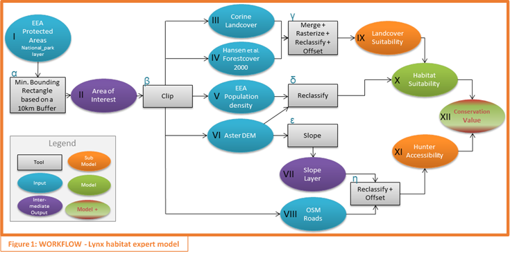
Figura 1: Fluxo de Trabalho - Modelo avançado de habitat Lynx
Descrição do fluxo de trabalho
Area of Interest [Step I – II]: Based on selected national park areas and adding a 10 kilometer buffer, a minimum bounding box [α] was created and clipped with the outline of the river Danube (derived from Corine Land Cover 2006). Further clipping tools [β] were applied to all additional data as an initial preparation step (Figure 2)
Land Cover Suitability Model [Step IX]: [γ] Input III and IV were transformed into shape files using the inbuilt #Polygonize function. Corine Landcover (2006) data was reclassified using the field calculator to group land use classes and assign respective index values. Similar processing was applied to Hansen Forestcover data (2000), extracting only areas of cover equal or higher 75 %. Sub-model IX was produced by using the functions #Merge Shapes to combine III with IV and #Rasterize
Note: Land cover classes were grouped by possible lynx occurrence and human activity. Although technically of older origin, information related to forest cover values were integrated in order to indicate habitat improvement and as a general example for joining spatial data sets
Habitat Suitability Model [Step X]: [δ] An Elevation Suitability Index was derived from the AsterDEM 2.0 [VI] and together with a Population Density Index [V] was integrated into the final habitat suitability model (Figure 3) by using the #Raster calculator
Cover Suitability Model * Population Density Index * Elevation Suitability Index
Note:Defining forest (>= 75 % cover) as best suitable and using the elevation data to reduce index values above assumed tree line is conceptually related to habitat of deer as the main prey
Potential Hunter Accessibility Model [Step XI]: Applying the #Terrain analysis tool [ε], a slope layer was extracted from the DEM data and combined [η] with a road distance layer, which was produced by processing rasterized OSM road data within the #Proximity function and index values assigned using #Reclassify grid values
.
                      Slopelayer
Road distance * ( 1 + ----------- )
                         100
Conservation Value Model [Step XII]: Is the result of the #Raster calculator function: (Figure 4)
(Habitat Suitability Model * Hunter Accessibility Model)
--------------------------------------------------------
                       2
Note: The Hunter Accessibility Model shall indicate the decreasing likelihood of hunters accessing the area by further distance to roads and increasing slope
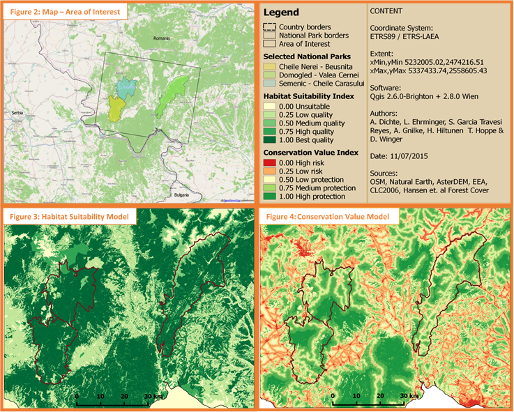
Figura 2, 3 e 4
Conclusão
Looking at the final output (Figure 3), a plausible first potential habitat analysis appeared to be successful, yet more importantly, basic modeling itself turned out to be less difficult than initially expected. Our choice to add a sub-model for hunter accessibility allowed us to implement another dimension in terms of habitat risk assessment, which can be simply nested into the already existing scenario and used to determine protection necessities under aspects of e.g. infrastructure development. However, some crucial habitat information, such as forest structure (our highest habitat suitability) cannot be derived by available data sets and in combination with the complex species behavior, the result must therefore be understood as basic and incomplete. Additional factors not implemented at this stage are road mortality, terrain roughness and detailed prey occurrence.
Besides its open source, free available character, QGIS software has been the subject of major developments in recent years. We made very positive experience with the integration of the tool box, allowing the use of various GRASS and SAGA tools, even for inexperienced users. No compatibility issues occurred despite changing frequently between different versions and the general absence of administrative restrictions can be a powerful advantage when working intuitively with data sets. We are looking forward seeing further improvements, especially in regards to the integrated model builder.
Referências
Kaczensky, P., Chapron, G.,von Avrx, M., Huber, D., Andrén, H. & Linnell, J. (December 2012): Status, management and distribution of large carnivores in Europe. Document European Commission.
Schadt, S., Revilla, E., Wiegand, T., Knauer, F., Kaczensky, P., Breitenmoser, U., Bufka, L., Cerveny, J., Koubek, P., Huber, T., Stanisa, C. & Trepl, L. (2002): Assessing the suitability of central European landscapes for the reintroduction of Eurasian lynx. Article Journal of Applied Ecology.
Salvatori, V. (2004): Conservation areas for large carnivores in the Carpathian Mountains. PhD Thesis.
Podgórski, T., Schmidt, K., Kowalczyk, R. & Gulczyñska, A. (2008): Microhabitat selection by Eurasian lynx and its implications for species conservation. Acta Theriologica 53: 97–110.
Boutros, D. (March 2002): Characterization and assessment of suitability of Eurasian lynx (Lynx lynx) den sites. KORA Report No. 12e, Diploma thesis.