QGIS 3.14 の変更履歴

リリース日: 2020-06-19
私たちが18年間の開発で行ってきたQGISのすばらしいリリースの軌跡の中にまた1つ素晴らしいリリース。このリリースには新機能と改良点が大小さまざまに詰まっているため、どこから始めればよいかわかりません。マーキー機能は、ベクタタイルのサポート、mdal /メッシュサポートの大幅な進歩、WMS-T、PGラスタ、ベクタプロバイダ、メッシュレイヤの一時データのネイティブサポートなどです。地図作成とデジタル化に重点を置いたユーザーも除外されておらず、多くの新しいオプションが用意されています。
謝辞
開発者、ドキュメント作成者、テスター、そして時間と労力を提供してくれる(あるいは人々に資金を提供してくれる)多くの人々に感謝いたします。QGISコミュニティとして、皆様にはこのリリースを楽しんでいただければと望みます。時間やお金を寄付したり、QGISをより素晴らしいものにするのに関わりたいという方がいらっしゃいましたら、 QGIS.ORG に行ってお手を貸してください!
QGISは寄付者と維持会員によってサポートされています。プロジェクトへの大小の献金を行った寄付者の現在のリストは、 寄付者リスト に掲載されています。公式のプロジェクト維持会員になりたい場合は、 維持会員ページ に行って詳細をご覧ください。QGISに出資いただけると、定期的な開発者会議への資金提供、プロジェクトインフラストラクチャの維持、バグ修正作業への資金提供に役立ちます。現在のスポンサーの完全なリストを以下に示します。すべてのスポンサーに大変感謝します。
QGIS はフリーのソフトウェアです。利用する上で金銭を支払う義務はありません。実際、私たちは利用者の財政状況や社会的地位にかかわらず、より多くの人に QGIS を利用して欲しいと思っています。私たちは地理空間的な意思決定ツールによって人々が力を持つことが、全人類の社会をより良くすると信じています。
一般情報
機能: 新しいグリッド地図整飾注記フォントの設定
マップキャンバスのグリッド地図整飾の注記は、フォントの色、バッファなどを含めて完全にカスタマイズ可能になりました。
この機能は iMHere Asia によって資金提供されました
この機能は Mathieu Pellerin によって開発されました
時系列(Temporal)
機能: 時間コントローラの累積的な時系列範囲の設定
時間コントローラに設定を追加して、アニメーションの時系列範囲を累積に設定します。これにより、すべてのアニメーションフレームは同じ開始日時と、異なる終了日時を持つことになります。
これは、データ全体に「移動する時間窓」を表示する代わりに、時間の視覚化でデータを蓄積したい場合に便利です。
この機能は Meteorological Service of Canada によって資金提供されました
この機能は Kartoza / Samweli Mwakisambwe によって開発されました
機能: 一時ベクタレイヤのための新しい「再描画レイヤのみ」モードを追加
このモードに設定すると、時系列範囲が変わったときにレイヤは自動的に再描画されますが、時間ベースのフィルタリングは地物に適用されません。
この設定は、レイヤに時系列範囲に基づくシンボロジ設定がある場合に便利です。例えば、レイヤが時間依存のルールベースのレンダラ式やデータ定義のシンボロジ式を使用している場合です。
この機能は Nyall Dawson によって開発されました
機能: ベクタレイヤに基本的な時間処理サポートを追加する
これは、ベクタレイヤの基本的でネイティブな時間機能を見えるようにします:
レイヤの静的な時間範囲(ラスタレイヤの可能性に合わせるため)は、レイヤ全体に適用される単一の静的な時間範囲を設定します。キャンバスの時間がレイヤの時間範囲と重なる場合、レイヤのすべての地物が表示されます
「DateTimeを持つ単一フィールド」: レイヤから単一のDateまたはDateTimeフィールドを選択することができます。このフィールドの値がキャンバスの時間範囲内にある場合、地物が表示されます
「開始と終了日時の別々のフィールド」: レイヤから開始と終了のDate/DateTimeフィールドを選択することができます。キャンバスの時間範囲とこれらのフィールドから計算される時間間隔が重なる場合、地物が表示されます
将来的には、「開始時刻+固定期間」、「開始時刻+フィールドの期間」、「式を使用した開始と終了時刻」などのモードを追加することを検討する必要があります
いくつかの既知の制限/非効率性:
現在、Date/DateTimeフィールドのみが使用できます。これは、形式の処理を簡素化し、異なるDateTime形式の文字列フィールドについて心配する必要をなくすために行われました。将来的には、文字列フィールドの選択とユーザーがカスタムDateTime形式文字列を入力できるようにする必要があります
ここで採用されているアプローチは、Time Managerプラグインアプローチとは異なり、QGIS式と地物リクエストに完全に依存してフィルタリングを実行します(Time Managerはレイヤフィルタ文字列を使用し、ネイティブSQLフィルター構文を設定して、バックエンドでフィルタリングが実行されるようにします) 。これは意図的です、なぜなら使用されるプロバイダに関係なく、統一されたフィルタアプローチを提供するからです(つまり、さまざまなプロバイダで固有に使用されるさまざまなSQL構文について心配する必要はありません)。地物リクエスト式のコンパイルの美しさは、QGIS式がネイティブバックエンドクエリ、BUUUUUUUUUUUT ...に魔法のように変換されることを意味 すべき です、DateTimeリテラルに対するQGIS式のサポートがないため、現在は「to _datetime」式関数に依存しており、文字列を介してすべてを強制しています。式コンパイラはこの関数を処理しないため、現在 *all* フィルタリングはQGIS側で行われます。最適化されたDateTimeリテラル作成用の関数を追加し、さまざまなコンパイラがこれらのリテラルをバックエンドフィルタ構文に正しくマッピングして、すべてのフィルタリング作業をデータベース側で実行できるようにする必要があります...
現在、大きなレイヤで時間マネージャと比較して、パフォーマンスが非常に悪くなっています(また、例えば補間処理がないなど、見せる地物のセットは小さいです)。しかし、利点として、ネイティブの時間フレームワークを使用し、ベクタレイヤをメッシュとラスタレイヤと一緒にアニメーション化することができます!
この機能は Nyall Dawson によって開発されました
機能: Postgresラスタ時間APIのサポート
Postgresラスタの時間機能の統合を追加。
この機能は ARPA Piemonte によって資金提供されました
この機能は Alessandro Pasotti によって開発されました
機能: QGISプロジェクトの時間設定
この機能はプロジェクトの時間設定機能を追加します。
プロジェクトの時間範囲を手動入力または現在のプロジェクトの時間レイヤから計算することによって設定できます。後者は、提供された「レイヤから計算する」ボタンをクリックすることで行うことができます。
この実装は、QGISの時間レイヤにアニメーション機能を追加するための段階を設定します。
プロジェクトの時系列範囲を設定する例を示します。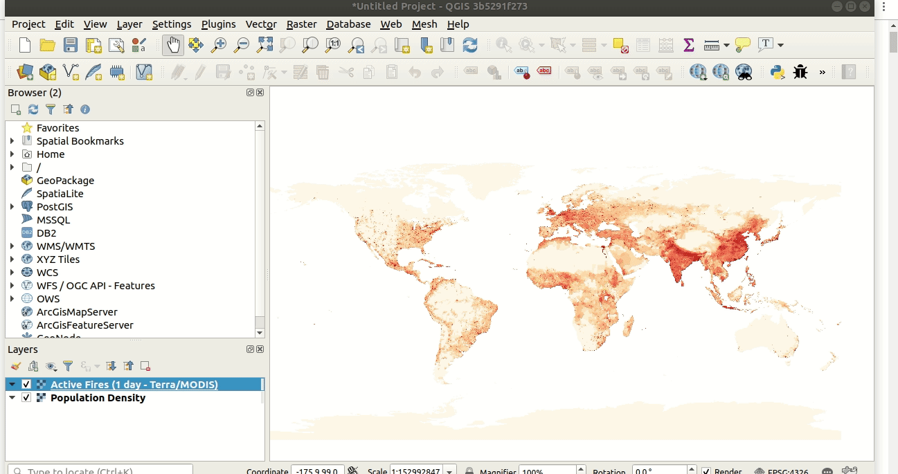
QGISの時間サポートに関する以前の議論は、ここ と ここ にあります。
この機能は Meteorological Service of Canada によって資金提供されました
この機能は Kartoza / Samweli Mwakisambwe によって開発されました
機能: WMS-Tレイヤの時間制約のサポート
この機能により、QGIS内でWMS Temporal(WMS-T)レイヤを制約する機能が追加されます。WMS-Tプロバイダからの任意の時間レイヤの日付時刻範囲を制約することができます。
この実装では、ユーザーはレイヤのプロパティダイアログのソースタブからレイヤの必要なDateTime範囲を指定できます。
以下はワークフローの例です。 
注意: 時間リクエストの瞬間ポイントの場合、開始と終了のDateTimeが等しい範囲を指定すると、範囲ではなく、指定されたDateTime瞬間が使用されます。
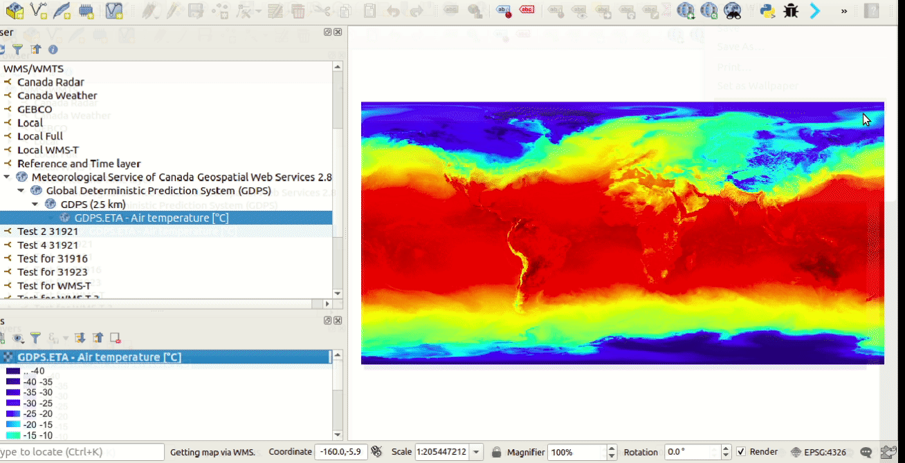
この機能は Meteorological Service of Canada によって資金提供されました
この機能は Kartoza / Samweli Mwakisambwe によって開発されました
機能: 時間API
この機能は、QGISでの時間サポートのためのAPI実装を提供します。
PythonのAPIは、Pythonドキュメントで 'Temporal' を検索すると見つけることができます(link)。
この機能は Meteorological Service of Canada によって資金提供されました
この機能は Kartoza / Samweli Mwakisambwe によって開発されました
ツール
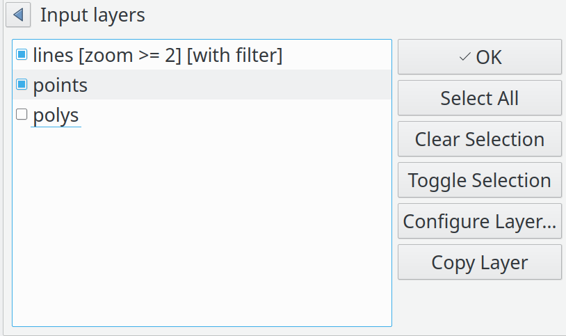
機能: QGISベクタタイルレイヤの識別ツールサポート。
識別マップツールは、ベクタタイルの地物の属性を調査することができるようになりました。
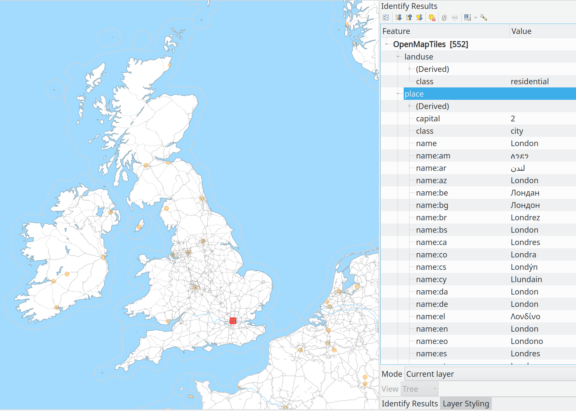
この機能は Many funders によって資金提供されました
この機能は Lutra Consulting (Martin Dobias) によって開発されました
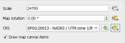
機能: 印刷レイアウトマップからウィジェットを直接スケールに設定するために、スケールウィジェットボタンの隣にメニューを表示する
スクリーンキャストは千の言葉を語ります:
この機能は Nyall Dawson によって開発されました
機能: 「現在のアクティブなレイヤから地物の選択を解除」にツールボタンを追加
この機能は Ivan Ivanov によって開発されました
ユーザーインタフェース
機能: 複数のQGISインスタンス間でレイヤのドラッグ&ドロップができる
この機能は QGIS Swissユーザーグループ によって資金提供されました
この機能は Denis Rouzaud によって開発されました
機能: 属性テーブルをタブとして開く
オプション「新しい属性テーブルをドックウィンドウとして開く」が有効な場合、新しい属性テーブルは既存の属性テーブルの上にタブとして開かれます。
この機能は Germán Carrillo によって開発されました
シンボロジ
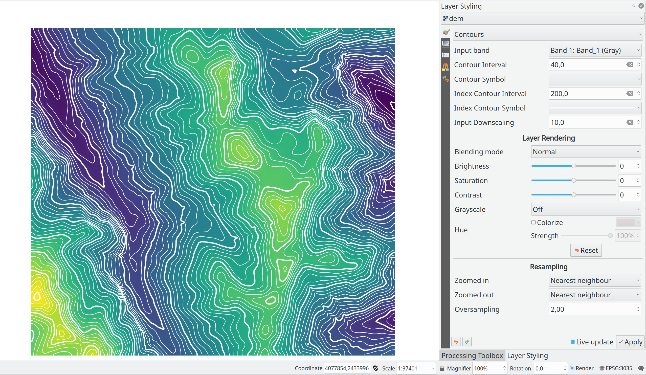
機能: ラスタレイヤの等高線レンダラ
この新しいレンダラーは、ソースラスタバンドからオンザフライで計算された等高線を描画します。等高線の間隔と描画に使用するシンボルを設定することができます。
さらに、「インデックス等高線」 - 幅広の線シンボルでよく描かれる、より高い間隔を持つ等高線も対応します。
もし、私たちの出力ラスタブロックと同じサイズの入力ラスタブロック上に等高線を生成すると、その生成結果の線は細か過ぎます。この細かさは、"downscale" 係数 - これにより、ソースラスタの低解像度が要求されます - によって削減することができます。
この機能は Martin Dobias によって開発されました
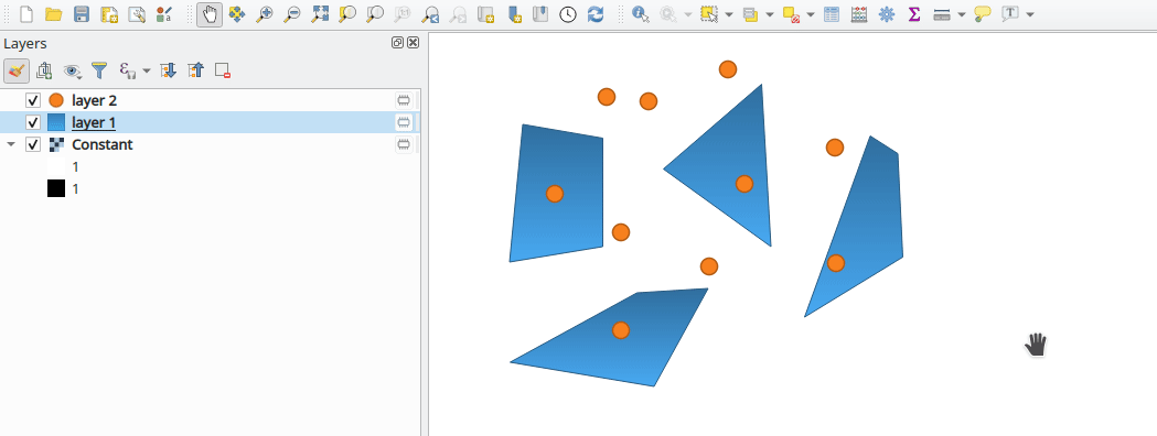
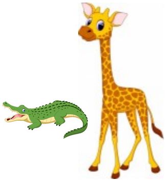
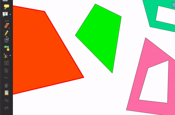
機能: ラスタイメージマーカーとラスタ塗りつぶしレイヤシンボロジにパーセンテージの大きさ単位を追加
機能のリクエスト によると、このパッチは**ラスタイメージマーカー** と ラスタ塗りつぶし のサイズ単位に新しいパーセンテージ(元の画像サイズの)値を追加します(nirvn の提案によるもの)レイヤ。
例えば、様々なサイズとアスペクト比のラスタ画像が含まれているレイヤ:


もし既存のラスタ画像マーカーの サイズ単位 値を使用すると、レイヤは次のようになります(通常のワニと、巨大なキリン):
または、このようになります(通常のキリンと、小さなワニ):
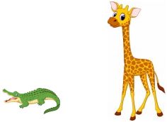
新しい パーセンテージ 値のサイズ単位は、この問題を修正することを意図しています。
単位テスト "qgis_rasterfilltest" と "qgis_rastermarkertest" の両方が、サイズ単位の提案された パーセンテージ 値をテストするために新しいコントロールイメージのセットで書き直されました。
この機能は beketata によって開発されました
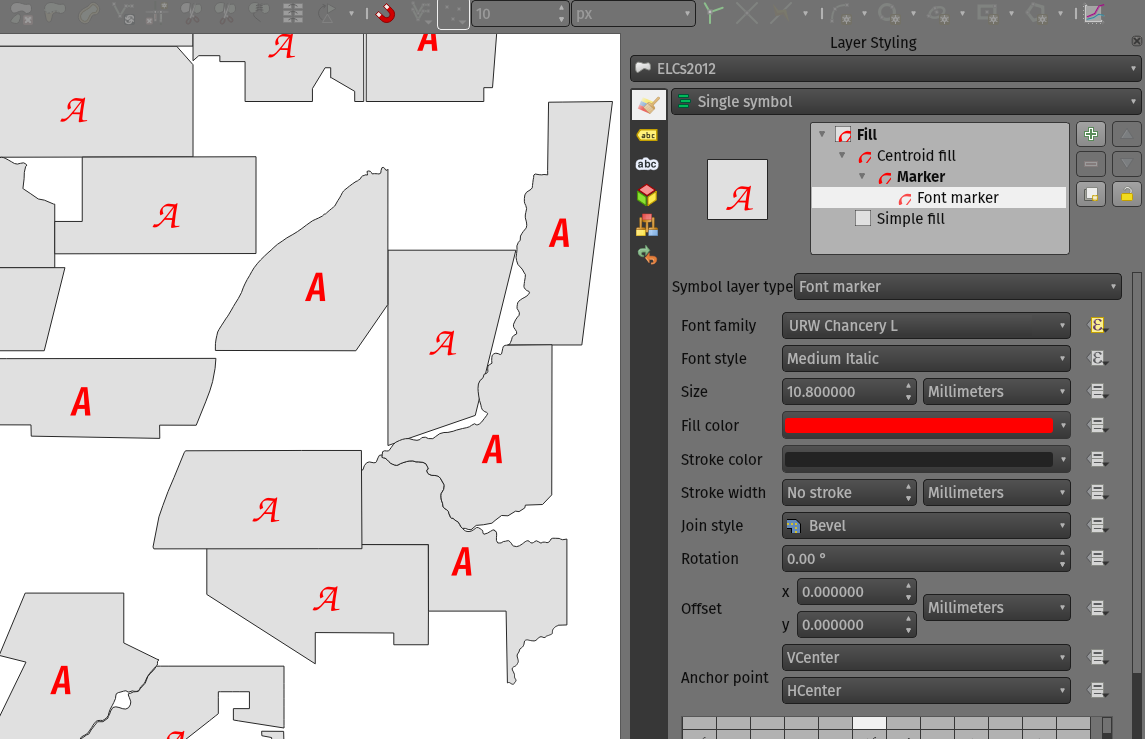
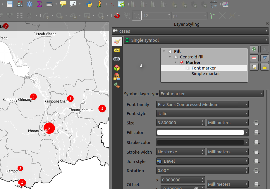
機能: フォントマーカーのフォントファミリ/スタイルにデータ定義型プロパティを追加
フォントマーカーのフォントファミリと新しいフォントスタイルプロパティにデータ定義プロパティが追加されました。これは、データ定義プロパティがデータセットの重複を回避できる多言語コンテキストなど、多くのシナリオで役立ちます。
この機能は iMHere Asia によって資金提供されました
この機能は Mathieu Pellerin によって開発されました
機能: フォントマーカーに新しいフォントスタイルの設定
この新しいフォントスタイル設定により、以前利用できなかった非デフォルトのフォントファミリのスタイルを選択することができます。
この機能は iMHere Asia によって資金提供されました
この機能は Mathieu Pellerin によって開発されました
ラベリング
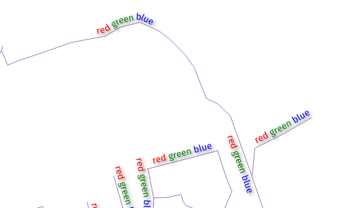
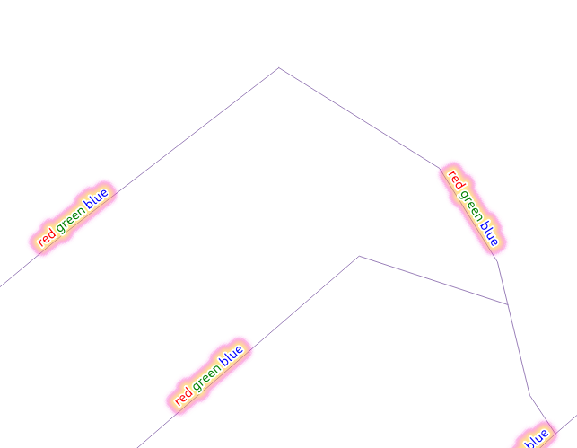
機能: ラベルでHTML色を配慮する
このオプションを有効にすると、ラベルの内容をHTMLとして扱い、レンダリングされたラベルでフォアグラウンドカラーに関連するHTMLの書式設定オプションが適用されます。
注意: HTMLカラータグのみが尊重されます。これはバグではありませんが、ラベルのHTMLフォーマットに関する「下調べ」としてこの機能が設計されたため、フォントの形状を変更しないフォーマットオプションのみが考慮されました。
良い面では、それは影、バッファ、曲線ラベルなど、他の全てのラベル設定と正しく動作します!
いくつかの美しい写真をご覧ください:
この機能は geoProRegio AG によって資金提供されました
この機能は Nyall Dawson によって開発されました
機能: ポリゴンの外側にラベルを自動的に配置する
この機能は、ポリゴン地物の外側にラベルを自動的に配置する能力を追加します。
これはたくさんの方法で見られます:
新しい配置モードは、常にポリゴンのラベルを地物の外側に配置します:
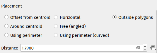
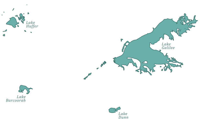
他のポリゴン配置モードを使用する場合、「ポリゴンの外側にラベルを配置することを許可する」新しいチェックボックスをチェックしてポリゴンの内部に配置することができない場合にラベルを外側に配置することができます:
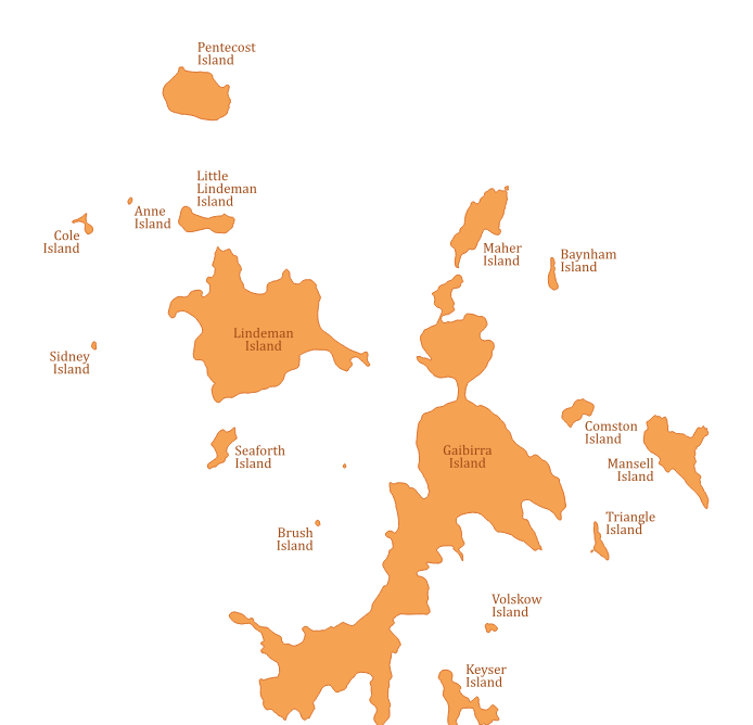
「外側にラベルを配置することを許可する」チェックボックスはデータ定義にでき、ユーザーは地物ごとに外側ラベルを許可、外側ラベルを防止、または外側ラベルを強制することができます。
配置アルゴリズムは、Rylov&Reimer(2016)「 エリア地物の外部注釈のための実用的なアルゴリズム 」の修正に基づいています。 Rylov&Reimerは、候補ラベルポイントを選択するための水平スイープラインベースのアプローチを提案していますが、実際には、ポリゴンの外輪を横断して一定の間隔で候補ポイントを生成するだけで、結果が劣る(そして遅くなる)ことがわかりました(特に狭く、ほぼ水平なポリゴンの場合)。
上記の諸島スクリーンショットに示されているように、「ラベル配置に従う」の複数行配置モードでは、外側配置モードが期待どおりに機能します。
この機能は Swiss QGISユーザーグループ によって資金提供されました
この機能は Nyall Dawson によって開発されました
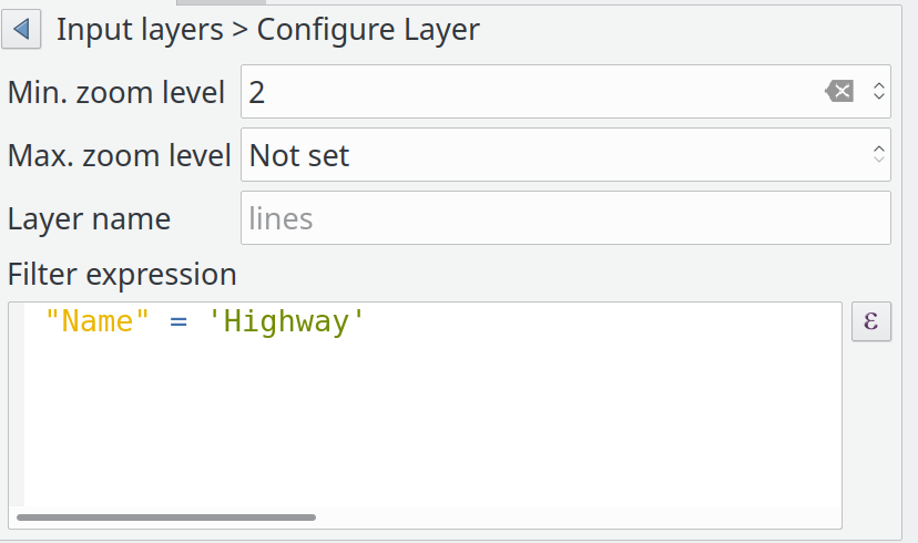
機能: ベクタタイルレイヤ - パート4 (ラベル付け)
ベクタタイルレイヤの実装に関する継続作業。
これにより、ベクタータイルレイヤーのラベル付けサポートが追加されます。これまでのところ、これは qgis_core... で機能しています.GUIサポートは次に来るでしょう。ラベル付けは、ベクタータイルのレンダリングと同じ概念を使用します。ラベル付けスタイルのリストがあり、それぞれがサブレイヤー名、ジオメトリタイプ、フィルター式、ズーム範囲、そしてもちろんラベルスタイル構成(QgsPalLayerSettings)によって定義されます。
ラベル付けには「鶏が先か卵が先か」の問題があることに注意してください。ベクタータイルの場合、レンダラーとラベル付けが要求するフィールドに基づいてサブレイヤーのQgsFieldsを作成しますが、ラベル付けでは、必要なフィールドがない場合は取得できませんでした。式のコンテキストですでに使用可能です(したがって、QgsProperty、QgsPropertyCollection、QgsPalLayerSettingsにいくつかの小さな追加を追加して、内部式を同時に準備しないことで必要なフィールド名を取得できるようにします)。
上記のラベリングをPythonコンソールで設定する例:
s = QgsVectorTileBasicLabelingStyle()
s.setLayerName("place")
s.setGeometryType(QgsWkbTypes.PointGeometry)
s.setFilterExpression("rank = 1 AND class = 'country'")
ls=QgsPalLayerSettings()
ls.drawLabels=True
ls.fieldName="name"
ls.placement = QgsPalLayerSettings.OverPoint s.setLabelSettings(ls)
labeling = QgsVectorTileBasicLabeling()
labeling.setStyles([s])
iface.activeLayer().setLabeling(labeling)
この機能は Many funders によって資金提供されました
この機能は Lutra Consulting (Martin Dobias) によって開発されました
機能: ラベルの引き出し線にアンカーポイントの制御を追加する
ラベルテキストに引出し線付きラベルがどこで結合するかを制御できます(以前は引出し線付きラベルが対応する地物のジオメトリにどこで結合するかの制御しか持っていませんでした)。
選択肢は次のとおり:
最近傍点(以前の動作)
ラベルの重心
固定された角:左上/右上/左下/右下/など
ラベルのアンカーをデータ定義で制御することも可能です。
ある程度引出し線付きラベルの醜さの修正に役立ちます!
以前の結果(最近傍点モード):
新しい「重心」配置:
この機能は Nyall Dawson によって開発されました
メッシュ
機能: 指定されたデータセットグループのみを使う
この機能により、使用するデータセットグループを選択することができます。これは、ソースタブのメッシュレイヤプロパティダイアログで行うことができます。
新しいツリービューは、データプロバイダから利用可能な全てのデータセットグループを表示します。データセットグループは、チェック済み/チェック解除にすること、名前を変更することができます。
このウィジェットは、ファイルから追加のデータセットグループを読み込むためのボタン、ツリーを展開/折りたたむためのボタン、全てのアイテムをチェック済み/チェック解除するためのボタン、および、プロバイダからデフォルトをリセットするためのボタン(現時点では、元の名前のみ)も提供します。
アクティブなデータセットウィジェットのレンダラ設定では、チェック済みデータセットグループのみが表示されます。
この機能は Deltares によって資金提供されました
この機能は Lutra Consulting (Vincent Cloarec) によって開発されました
機能: 分類に応じたスカラの色設定
この機能により、MDALではデータセット内の分類されたスカラ値を読み取ります。値が分類されると、デフォルトのスカラレンダリング設定には、分類された値に従ってカラーランプシェーダとラベルが設定されます。
この機能は Deltares によって資金提供されました
この機能は Lutra Consulting (Vincent Cloarec) によって開発されました
機能: メッシュ要素にスナップする
メッシュ要素にスナップするためのメソッドをAPIに追加します。
メソッドは、最も近いメッシュ要素上のスナップされたポイントの位置を返します:
頂点の場合、スナップされる位置は頂点の位置です
辺の場合にスナップされる位置は、辺上の投影されたポイント、または辺の外側の場合は辺の先端です
面の場合にスナップされる位置は、面の重心です
返す位置は、地図の座標です。
この機能は Deltares によって資金提供されました
この機能は Lutra Consulting (Vincent Cloarec) によって開発されました
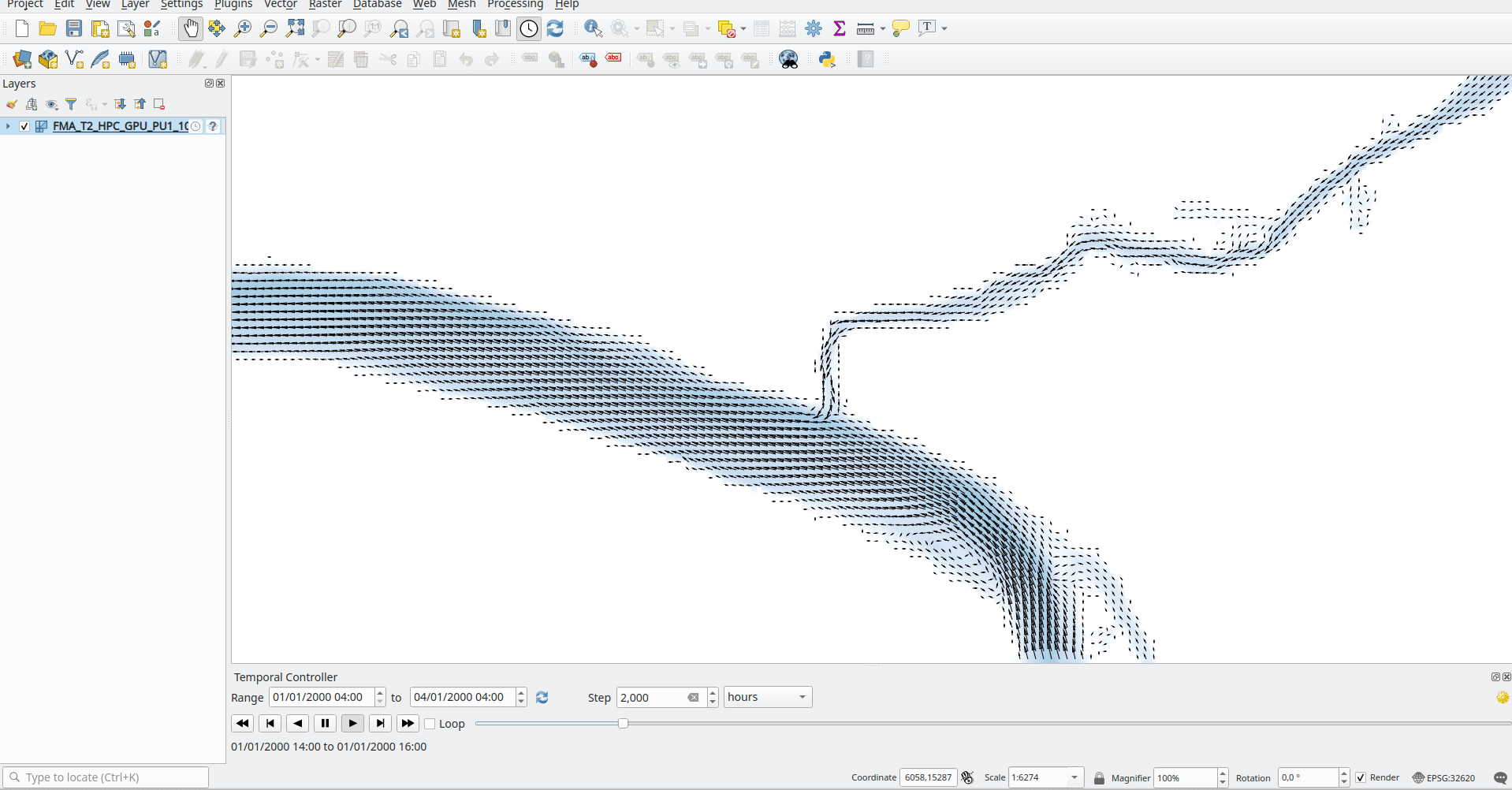
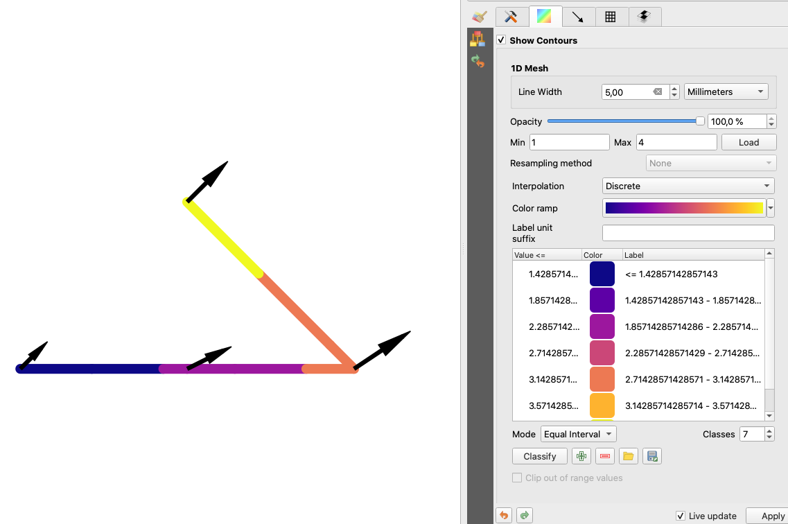
機能: 1D メッシュの幅/色の変化
この機能は、値に応じて変化するエッジの幅を持つ1Dメッシュをレンダリングする新しい方法を提供します。したがって、幅と色は、辺または頂点の値に応じて変化します。
ユーザーはレンダリングを設定するために最小/最大値と最小/最大幅を定義することができます。
色については、カラーランプシェーダー(2Dメッシュとラスタに対して)を定義できます。
この新しいレンダリングには、メッシュフレームワークの外でも使用できる新しい汎用クラスが導入されています。
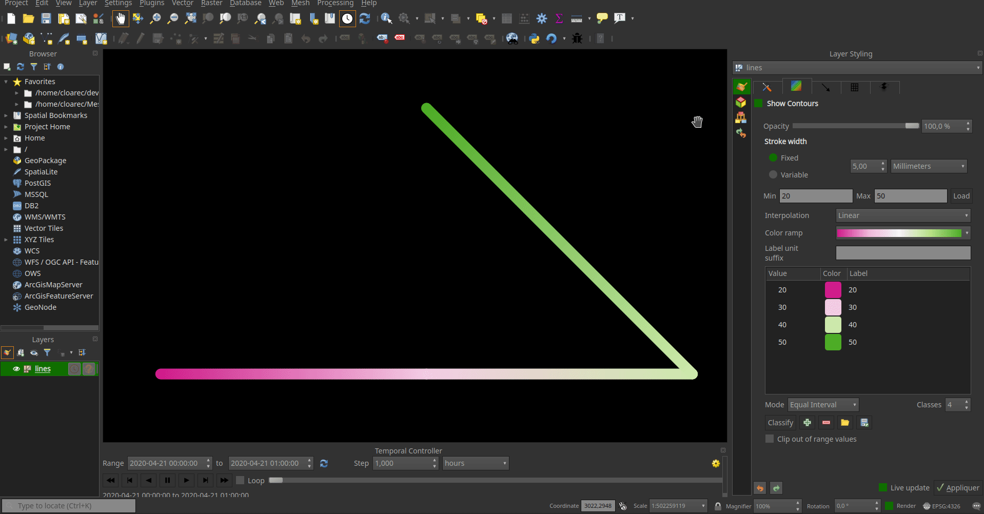
この機能は Deltares によって資金提供されました
この機能は Lutra Consulting (Vincent Cloarec) によって開発されました
機能: マルチパートメッシュのサポート (MDAL 0.5.91以降)
MDAL 0.5.91への更新に加えて、この機能により1つのファイルから複数のメッシュを読み込むことができます。
ファイルは解析され、ベクタまたはラスタレイヤと同じロジックを使ってサブレイヤダイアログが起動されます。
この機能は Deltares によって資金提供されました
この機能は Lutra Consulting (Vincent Cloarec) によって開発されました
機能: QGISの時間フレームワークにメッシュレイヤを接続
レイヤの中での時間の処理
メッシュレイヤの時間は次のように定義されます:
データ、プロジェクトまたはユーザーが提供する参照時間
それぞれのデータセットは相対時間と関連付けられます
時間範囲は、全てのデータセットの最初の時間と最後の時間によって定義されます
Reference time :          AT
Dataset 1 time            o---RT------RT-----RT-----------RT
Dataset 2 time            o-------RT------RT--------RT
Dataset 3 time            o--------------------------RT-------RT------RT
Time extent of layer      o----<---------------------------------------->

-  AT : absolute time (QDateTime)
-  RT : relative time (qint64)
QgsMeshDataprovidertemporalCapabilities クラスは、データによって提供される参照時間とデータセットのすべての相対時間を格納します。このクラスには、データセットグループインデックスからデータセットインデックスを返し、参照時刻からの相対時間を返す機能があります。参照時間(プロバイダの参照時間とは異なる場合があります)と絶対時間範囲は、クラス QgsMeshTemporalProperties に格納されます
プロパティウィジェットの時系列設定は、参照時間とプロバイダ時間の単位のみです: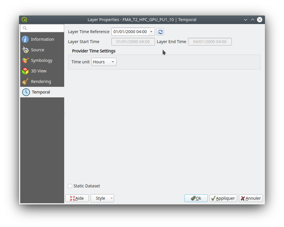
レイヤのデフォルトの参照時間は次によって設定されます(優先順に):
データに定義されていれば、データプロバイダ
定義されていれば、プロジェクト
現在の日付と時刻 00h00
ユーザーは望めば変更できます。
レンダリングの原則
2Dおよび3Dレンダラーは、 QgsContextRenderer と Qgs3DMapSettings に保存された時間範囲を持つレイヤからアクティブなデータセットインデックスにアクセスします:相対時間は QgsContextRenderer の時間範囲と QgsMeshTemporalProperties によって保存された参照時間の差として計算されます。データセットインデックスは、相対時間をデータセットインデックスにマップする QgsMeshDataproviderTemporalCapabilities から取得されます。
データはデータセットインデックスを使ってプロバイダから取得されます。
静的データセット
また、静的データセットを設定するオプションによって、QGISの時間コントローラーに独立してレンダリングされるデータセットを選択することができます。そのために、ユーザーはプロパティウィジェットの時系列ページの下部にあるチェックボックスをチェックすることができます: 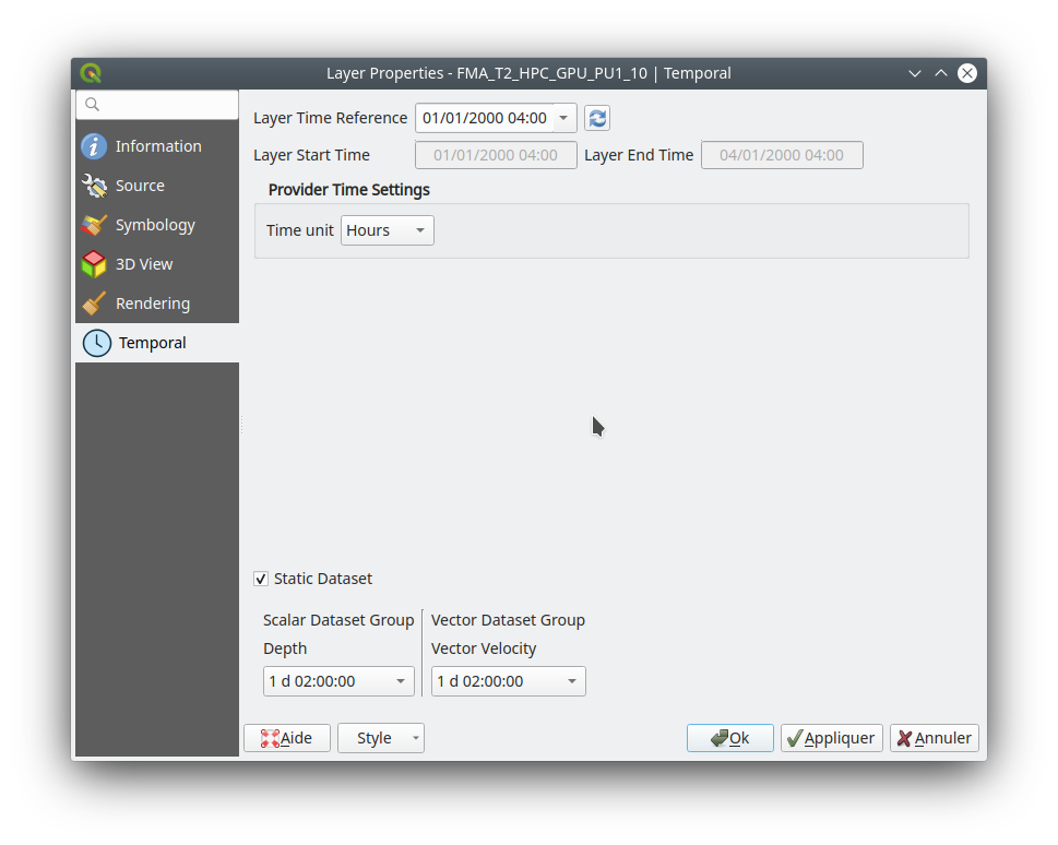 現時点では、実装が簡単で必要なデータセットを直接選択できるため、ユーザーはスカラデータセットとベクタデータセットをそれぞれのデータセットに関連付けられた時間(参照時間のないデータの場合は相対時間)を持つコンボボックスから独立して選択できます。必要に応じて、一意の時間を実装することもできますが、非同期のデータセットとの整合性のない結果になる可能性があります。静的データセットの設定は時系列ページにありますが、必要に応じてソースページに簡単に配置することもできます。
この機能は Lutra Consulting によって資金提供されました
この機能は Lutra Consulting (Vincent Cloarec) によって開発されました
機能: 頂点値から面値へのリサンプリング
面上で定義されたデータセットに対してリサンプリングが可能です。例えば、頂点の値は面の値から計算されます。
この機能はneighbor average methodを使った頂点上の値から面上の値へのリサンプリングを実装しています。
デフォルトで設定される方法は、頂点から面へのリサンプリングは「なし」、面から頂点へのリサンプリングは"neighbor average"です。その結果、デフォルトのレンダリングは常にスムーズです。 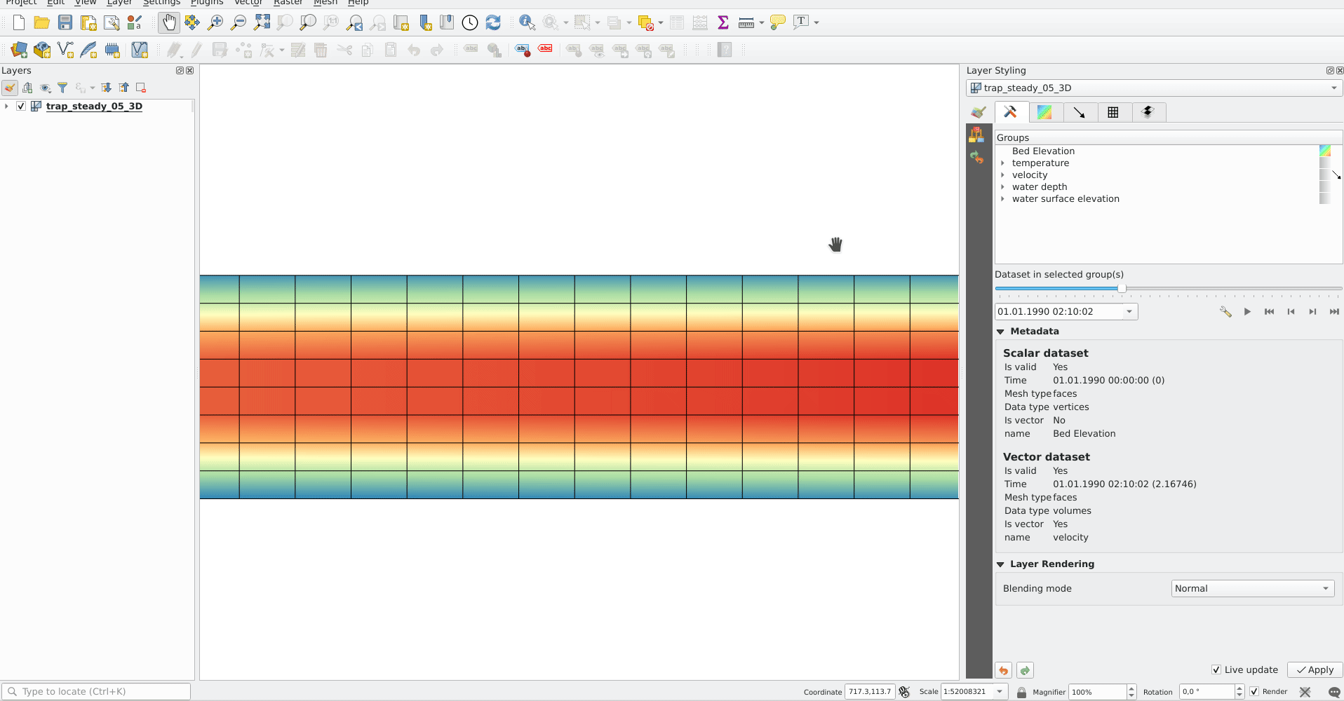
この機能は Lutra Consulting (Vincent Cloarec) によって開発されました
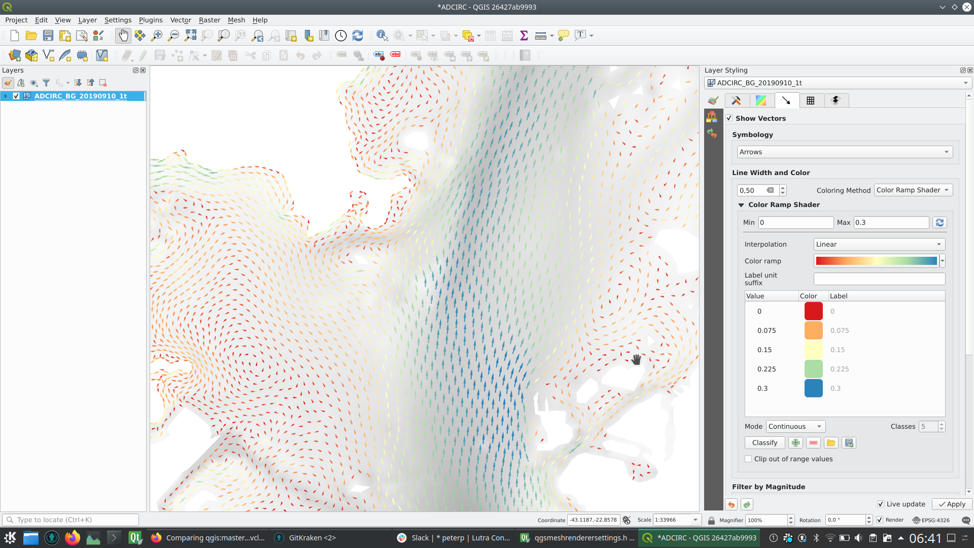
機能: カラーランプシェーダーを使ってメッシュベクタデータセットを着色する
この機能により、ベクタの大きさに応じて、メッシュレイヤベクタデータセット(矢印、流線、トレース)をカラーランプシェーダーで着色することができます。
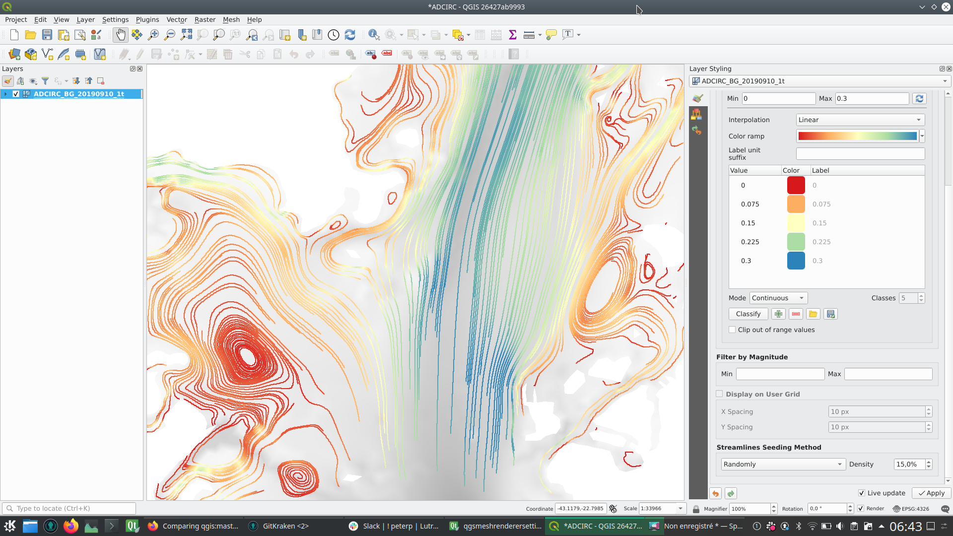
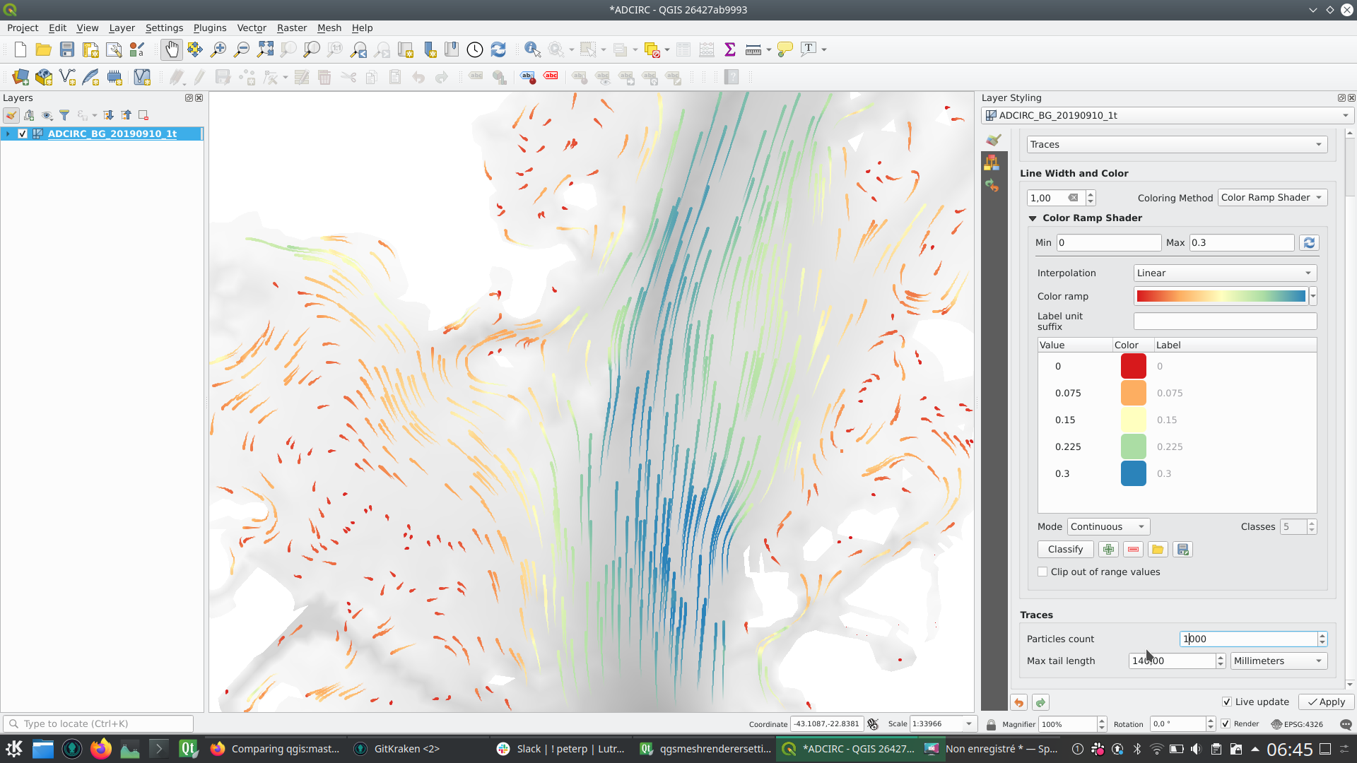
この機能は Deltares によって資金提供されました
この機能は Lutra Consulting (Vincent Cloarec) によって開発されました
機能: メッシュレイヤのスタイルを保存
この機能は、ベクタとラスタレイヤで利用されるqmlファイルにメッシュレイヤスタイルを保存するオプションを追加します。
機能はまた、ラスタとベクタレイヤのプロパティメニューのスタイルを再構築します。 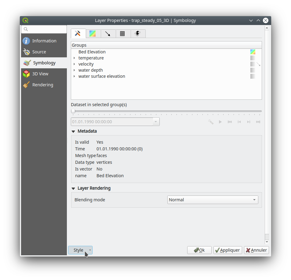
この機能は Artelia Group によって資金提供されました
この機能は Lutra Consulting (Vincent Cloarec) によって開発されました
機能: メッシュ 1D レンダラ
‘MDAL 0.5.90 <https://github.com/lutraconsulting/MDAL/releases/tag/0.5.90>`__ に更新
メッシュレイヤでの1D要素の対応 の初期実装
1Dメッシュは辺と頂点から構成されます。ひとつの辺は二つの頂点を結び、割り当てられたデータ(スカラまたはベクタ)を持つことができます。1次元メッシュネットワークは、例えば、都市の排水システムのモデリングに使うことができます。
メッシュフレームタブで1Dメッシュ(辺)を表示する新オプションがあります 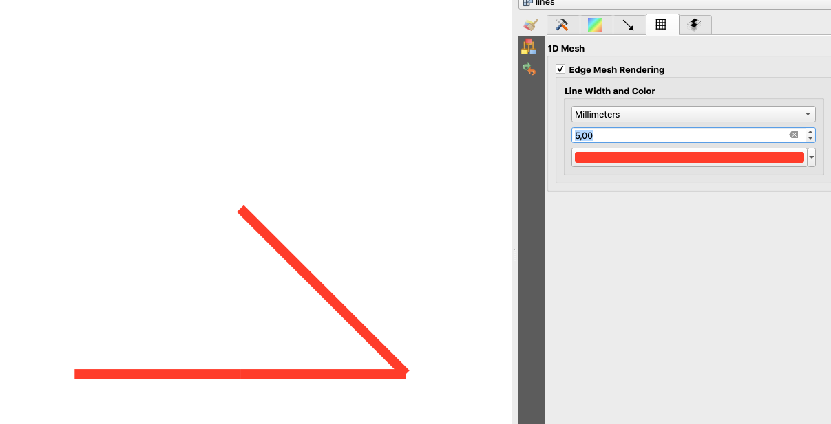
また、1Dメッシュ(辺または頂点)のデータについては、等高線タブに新しいオプションがあります
2Dメッシュで利用可能な機能の全てが利用できるわけではないことに特に注意してください
1Dメッシュのメッシュ計算機の対応
1Dメッシュの3Dレンダリング
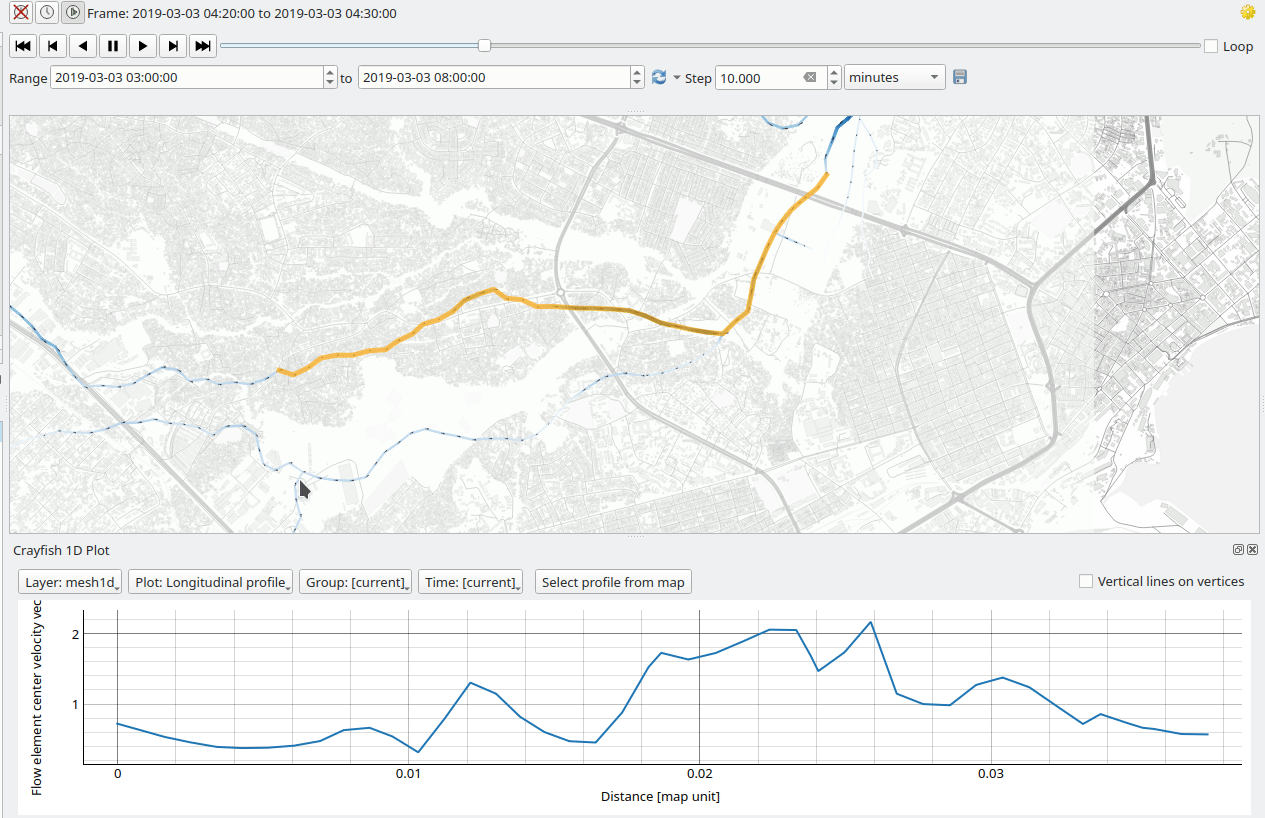
Crayfish内の識別とプロット(後で次のPRに追加されます)
1Dメッシュには必要ない機能がいくつかあります。特に
メッシュ等高線のエクスポート
この機能は Peter Petrik によって開発されました
機能: メッシュの単純化
メッシュレイヤは数百万の三角形を持つことができ、レンダリングは非常に遅くなることがあります。特に、三角形が小さ過ぎて見えないときでも、すべての三角形がビューに表示されるためです。
このような状況では、この機能はメッシュを単純化するオプションを提供します。単純化すると、詳細レベルを表す1つ以上の単純化されたメッシュになります。メッシュをレンダリングする場合、ビューに応じて適切なレンダリングを提供するために、適切な詳細レベルが選択されます。
メッシュレイヤのプロパティウィジェットにある新しいタブで、設定が変更できます:
削減係数は、メッシュを単純化するために使用されます。各詳細レベルの三角形の数は、前の詳細レベルの三角形の数を削減係数で割ったものにほぼ等しくなります。
最大メッシュ解像度:これは、表示できる三角形の平均サイズ(ピクセル単位)です。メッシュの平均サイズがこの値よりも小さい場合、詳細レベルの低いメッシュ、つまり平均サイズが最大メッシュ解像度よりもわずかに大きいメッシュが表示されます。
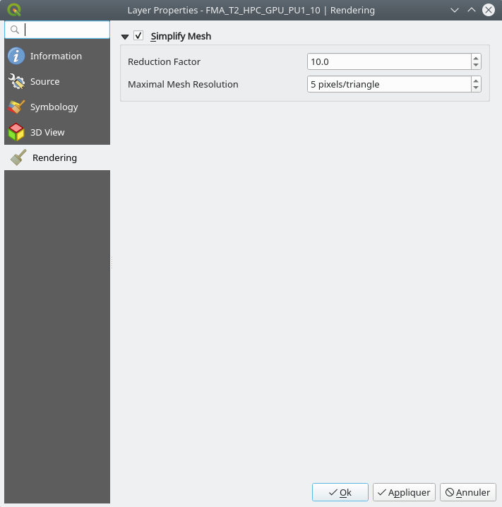
この機能により、以下の表(ミリ秒での結果)に示されるように、レンダリングの高速化が可能になります: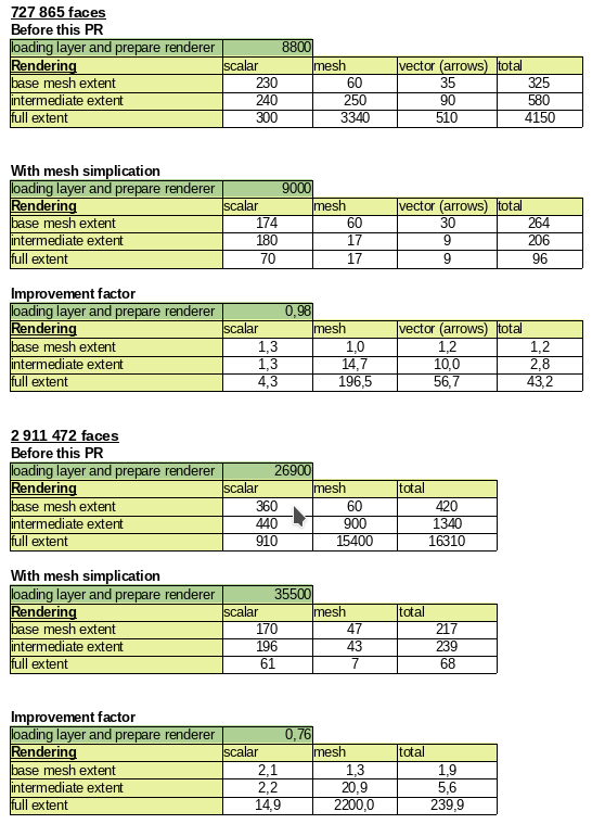
デモGIF 以前: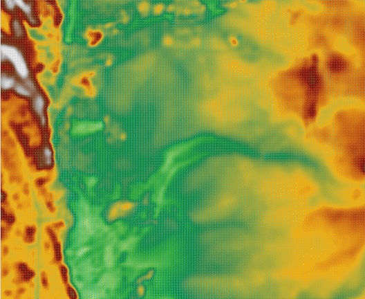
現在:
この機能は BMT によって資金提供されました
この機能は Lutra Consulting (Vincent Cloarec) によって開発されました
三次元機能
機能: 3Dメッシュレイヤデータセットのレンダリングの矢印
この機能は、ベクタデータセットに応じて、メッシュレイヤデータセットの3Dエンティティに矢印を表示するオプションを追加します。
矢印のレンダリングに使われるデータセットは、2Dレンダリング上のベクタをレンダリングするために選択されたものです。
同様に、矢印の色は、ベクタデータセットの2Dレンダリング設定で定義されます。
3Dの設定では、矢印の間隔と、サイズを固定するか、大きさに基づいてスケーリングするかを定義できます。
この間隔の設定は、矢印を重ねることができないため、矢印の最大サイズも定義します。 
この機能は Lutra Consulting (Vincent Cloarec) によって開発されました
印刷レイアウト
機能: レイアウトマップアイテムの一時的な設定
この機能は、ユーザーが地図のコンテンツをレンダリングする際に使用する時系列範囲を有効にし、設定することができる、レイアウトマップアイテムウィジェットに折りたたみ可能なセクションを追加します。
開始日時と終了日時の値はデータによって定義することができ、地図帳地物と一緒に使用すると便利です。
この機能は iMHere Asia によって資金提供されました
この機能は Mathieu Pellerin によって開発されました
機能:テーブルにリストされていないフィールドで属性テーブルをソートできるようにする
表示される列とソートする列に同じデータモデルを使用する代わりに、2つのデータモデルを使うようになりました。非常に似ているため、同じAPI / ベースクラスを使います。
この機能は Denis Rouzaud によって開発されました
機能: レイヤ凡例の分割動作の制御をレイヤごとに見えるようにする
これにより、ユーザーはレイヤごとに、凡例のデフォルト設定である「レイヤの分割」を手動で上書きすることができます。レイアウト凡例パネルでレイヤをダブルクリックし、レイヤが次のいずれかであるかを選びます:
分割のデフォルトの凡例設定に従う
(凡例の設定に拘わらず)常に複数のカラムに分割できる
または
(凡例の設定に拘わらず)複数のカラムに分割しない
SLYRによって後援されました
この機能は Nyall Dawson によって開発されました
機能: チックスケールバーの水平シンボルとは異なる目盛と小目盛シンボルのカスタマイズができる
チックスケールバー内の水平線シンボルとは異なる方法で、目盛と小目盛シンボルのスタイリングができます
SLYRによって後援されました
@agiudiceandrea の熱心な取り組みに基づいています!
この機能は Nyall Dawson によって開発されました
機能:凡例ノードのデフォルトシンボルを上書きできる
ユーザーは、凡例ノードのシンボルの見栄えを(オプションで)カスタマイズすることができます。例えば、地図上で実際に表示される対応する地物と比較して、「代表的な」パッチシンボルを提供するために色やシンボルのサイズを微調整することができます。
シンボルが地図コンテンツの上にレンダリングされたときに、色が実際の見栄えを表すように、シンボルの幅を誇張したり、半透明のシンボルの色を手動で微調整したりするのに便利です。また、マーカーラインのマーカー間隔/オフセットを微調整することで、マーカーが凡例パッチの中できれいに配置されます。
この機能は Nyall Dawson によって開発されました
機能: 凡例に手動で列の改行を配置できる
凡例アイテムを設定する際に、段区切りを配置してアイテムを新しい列に配置されるようにするオプションを追加します。
自動的な列の生成によって望む結果が得られない場合に、これによって列の内容を制御できます。
この機能は Nyall Dawson によって開発されました
機能: チックスケールバーの右セグメントに補助目盛を追加する
チックスケールバーの右側のセグメントに補助目盛を作る機能を追加します。
上向きチック 
中央チック 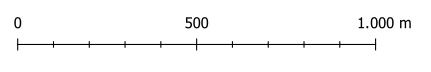
下向きチック 
スケールバーのアイテムプロパティ - セグメントグループボックス 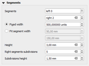
スケールバーの左側のセグメントに関連する動作は変更されていません。
この機能は Andrea Giudiceandrea によって開発されました
機能: 凡例パッチのサイズをアイテムごとに上書きできる
ノードをダブルクリックすることで、個々の凡例ノードのシンボルパッチサイズを上書きすることができます
幅と高さは個別に上書きでき、上書きが設定されていない場合は、ノードはデフォルトの幅または高さにフォールバックします。
SLYR によって後援されました 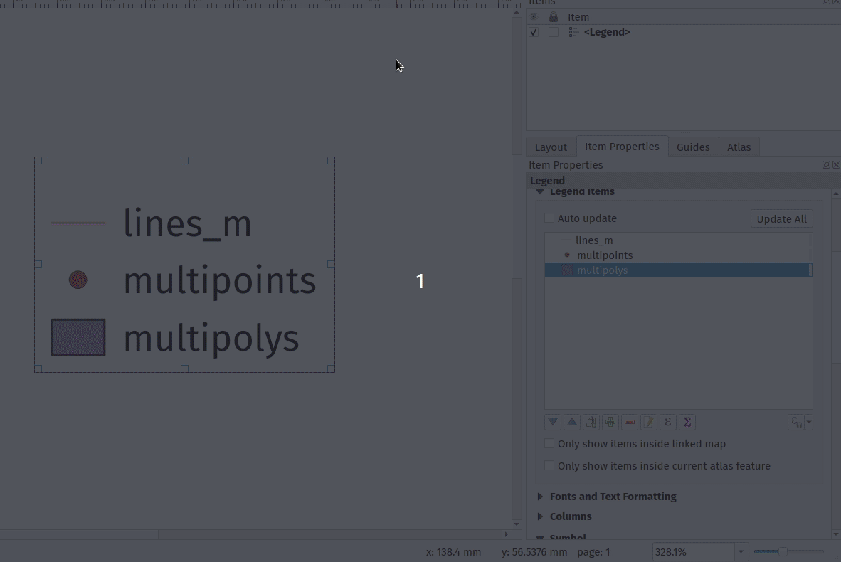
この機能は Nyall Dawson によって開発されました
機能: 凡例のグループ/サブグループ/シンボルの前の水平間隔を制御できる
凡例グループ/サブグループ/シンボルの「入れ子」を可能にする柔軟性と、凡例アイテムの配置をより大きく制御できるようにします。
SLYRによって後援されました
この機能は Nyall Dawson によって開発されました
機能: 凡例パッチのシェイプをスタイルマネージャから管理する
このアップデートでは、最近の凡例パッチのカスタマイズ作業を仕上げ、スタイルマネージャにカスタム凡例パッチのサポートを追加しました!
今は、本当に素敵なデフォルトのパッチセットが出荷に必要なだけです!
この機能は Nyall Dawson によって開発されました
機能: 凡例アイテムをダブルクリックすると凡例パッチの形状を設定できる
パッチのジオメトリを表すWKT文字列を入力することで、アイテムのカスタム凡例パッチを設定できます。
SLYRによって後援されました
この機能は Nyall Dawson によって開発されました
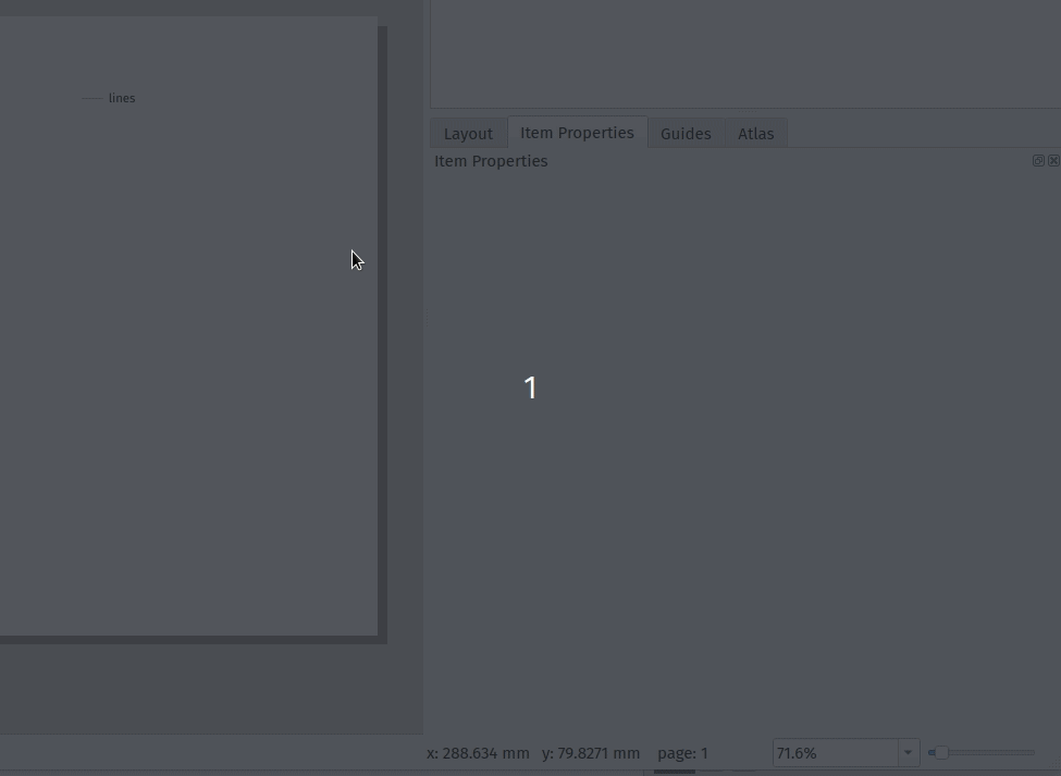
機能: 写真をレイアウトに直接貼り付けることに対応
貼り付けた写真をレイアウトに埋め込みます。
この機能は Nyall Dawson によって開発されました
機能: マーカーアイテムをマップに同期して回転できる
マーカーシンボルから方位記号を作成することができ、方位記号として機能する写真アイテムと同じオプションが利用できます。
マーカーが方位記号として機能する場合、マップの回転は既存のマーカーシンボルの回転に「追加」されます(例えば、三角形のマーカーを90%回転させて真っ直ぐに向ける必要がある場合でも、方位記号モードでうまく機能します!)
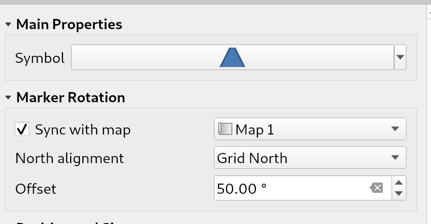
SLYRによって後援されました
この機能は Nyall Dawson によって開発されました
機能: マーカーシンボルに新しいアイテム型
マーカーシンボルをレイアウトに直接配置できるようにします。例えば、マップアイテム上にマーカーを手動で配置したり、高度なカスタム凡例を作成したりできます。
以前は、これらのサポートをハックする必要がありました。例えば、重心塗りつぶしシンボルを使用して四角形を描画することで対応していました。専用のアイテムタイプがあると、より具体的なカスタマイズオプションが可能になります(近日公開予定!)
SLYRによって後援されました
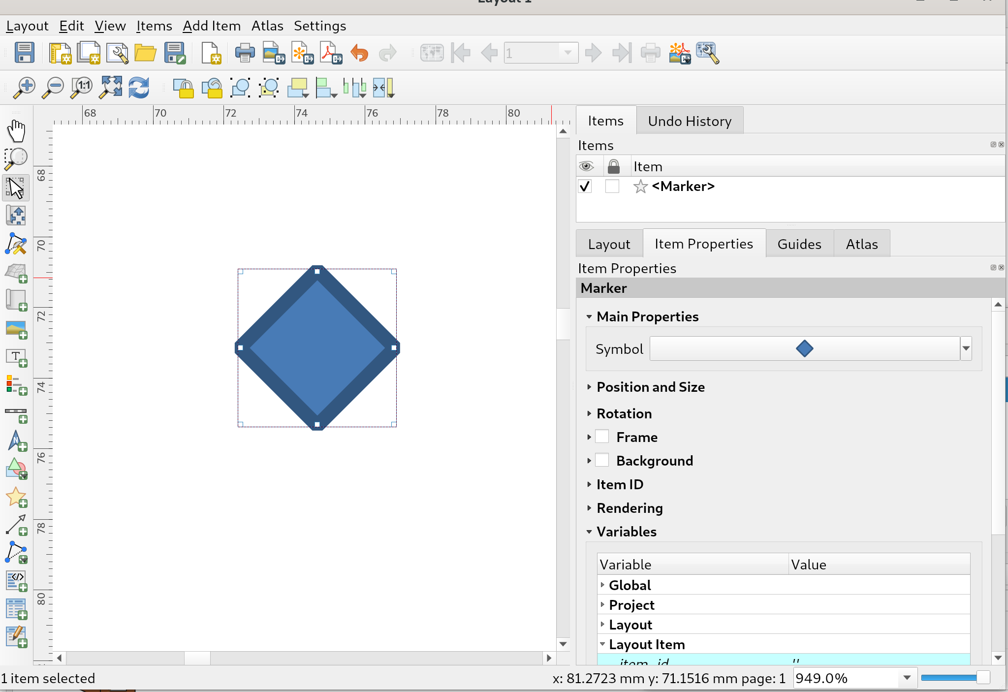
この機能は Nyall Dawson によって開発されました
機能: 固定テーブルのアイテムにクリップボードの内容をインポートを追加
QGISのテーブルエディタに、新しく、クリップボードから内容をインポートする機能が追加され、レイアウトが固定なテーブルアイテムのより迅速な編集と作成が可能になりました。
この機能は iMHere Asia によって資金提供されました
この機能は Mathieu Pellerin によって開発されました
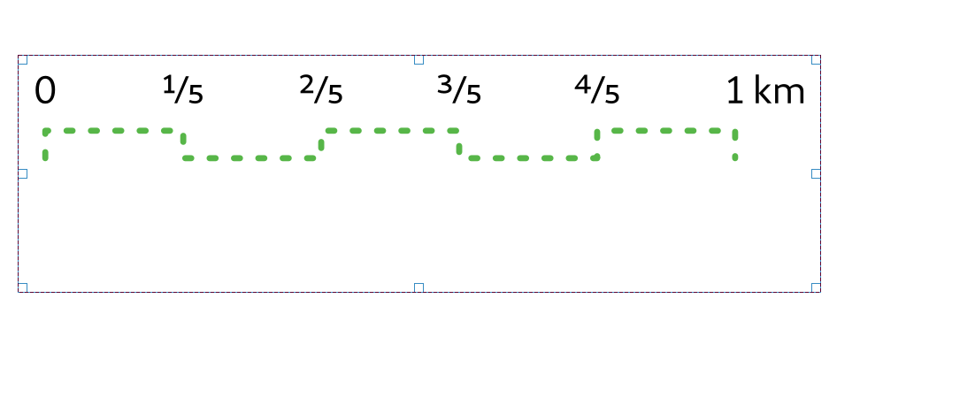
機能: 数値フォーマットに「分数」スタイルを追加
このスタイルは小数を分数で表します。例えば、0.75の代わりに"3/4"。
オプションには、より美しいタイポグラフィのためにUnicodeの上付き文字と下付き文字を使用する方法があります。例えば、¹⁷/₂₃(これがデフォルトモードで、このオプションを無効にすると"17/23"の形式が使用されます)。また、特定の分数に専用のUnicode文字を使用するオプションも存在します(Unicode文字が存在する場合)、例えば½や¾です。
最終的には、距離の分数表現を持つスケールバーの作成が可能になります、例えば、0 ----- ½ ----- 1 km (0 ------ 0.5 ------ 1km の代わりに)
SLYRによって後援されました
この機能は Nyall Dawson によって開発されました
機能: 「ステップ線」と「窪み箱」スケールバースタイルを追加
(ArcMapで利用できるが、これまでQGISでは再現不可能だった)2つの新しいスケールバースタイルを追加
ステップ線スタイル:
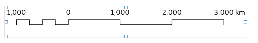
窪み箱(別名「南アフリカ」)スタイル:
SLYRによって後援されました
この機能は Nyall Dawson によって開発されました
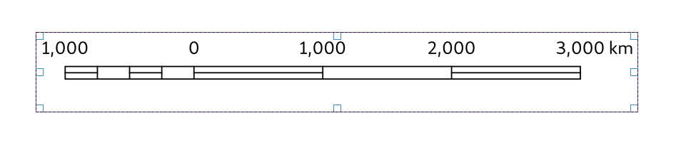
機能: 標準のQGISラインシンボルを使用してスケールバーのラインスタイルを設定できる
以前の、スケールバーの線の色/幅/先端スタイルの設定の代わりに、より高度なスタイリングのために、完全な線のシンボルとしてオプションを提供します。
コードのクリーンアップも行います。
SLYRによって後援されました
この機能は Nyall Dawson によって開発されました
機能: 写真アイテムのUIと動作を再設計
SVGまたはラスター画像ソース間の明示的な選択を追加します。これにより、特定の画像ソースに適用されないオプションを非表示にすることで、レイアウト画像の構成パネルをクリーンアップできます。また、以下を許可します:
標準のSVG選択ツリーウィジェットを再利用し、画像をバックグラウンドスレッドで読み込みます
標準のSVGおよび画像セレクターライン編集を使用し、画像のドラッグアンドドロップを許可し、画像の埋め込みオプションとオンラインソースへのリンクのオプションを公開します。
最終的には、これはユーザーがレイアウトやレイアウトテンプレートに画像を埋め込むことを可能にするという望みによって動機づけられています。
SLYRによって後援されました
この機能は Nyall Dawson によって開発されました
機能: 変数によってCRSを制御できるようにする
マップCRSを変数によって制御できるようにします。
#34547に関係
この機能は Alex によって開発されました
計算式
機能: 新しい式
asciimake_interval年/月/週/日/時間/分/秒の値から、文字列表現を作成せずに、インターバル値を直接構築することができます。maptiplayer_property('distance_units')display_expressioneval_templatemake_datemake_timemake_datetimeclose_lineis_multipartジオメトリのZとMの最小と最大
@frame_number@frame_rate@frame_duration@map_start_timeマップの時系列の時間範囲の開始(datetime値)@map_end_timeマップの時系列の時間範囲の終了(datetime値)@map_interval:マップの時系列の時間範囲の長さ(interval値)@animation_start_time@animation_end_time
この機能は Etienne Trimaille, Jan Caha, Julien Monticolo, Nyall Dawson によって開発されました
機能: 式ビルダでプレビューするための地物ブラウザ
この機能は、式ビルダに地物ブラウザを追加し、式の結果を表示するために地物を閲覧できるようにします 
新しいウィジェットが追加されました:QgsFeaturePickerWidget。現時点では、それは単なるコンボボックスです(ただし、ウィジェットを継承しているため、後でマップピッカーボタンを追加できます)。これは、リレーション参照ウィジェット内のものと同じように動作します(編集可能なコンボボックス)。
それは同じ基本モデル(QgsFeatureFilterModel)に依存しています。新しい抽象クラス QgsFeaturePickerModelBase は、ロジックをまとめ、新しいモデルは QgsFeaturePickerModel と呼ばれます。基本的に、QgsFeaturePickerModel は、地物IDを使用して地物を識別する一方、QgsFeatureFilterModel は属性のリスト(リレーションの外部キー)を使用します。かなり...混雑していた前のモデルを少し整理します。
ちなみに、QgsFeaturePickerModelBase のテンプレートを使用しようとしましたが、テンプレートはQ_OBJECTと混在できないため、代替案ではコードが読みにくくなる可能性がありました。
テストが追加されました。
QGISスイスユーザーグループ によって後援されました!
この機能は Denis Rouzaud によって開発されました
機能: カスタム関数を削除できる
ユーザープロファイルディレクトリに移動する必要なく、QGIS からユーザー関数を削除するために、式ビルダダイアログの関数エディタタブに削除ボタンを追加します。
この機能は Alexander Bruy によって開発されました
機能: ユーザー式を編集、インポート、エクスポートできる
保存された式の編集を可能にする、新しいボタンが追加されます。ユーザーの式が式ツリーで選択されている場合にのみ有効です。押すと、現在選択されているユーザーの式を編集するためのウィンドウが開きます。式のラベルを変更すると、現在存在するもののコピーが作成されます。デモ
インポートとエクスポート
メニュー付きの新しいボタンが追加され、JSONファイルとの間でユーザー式をインポート/エクスポートできるようになりました。メニューエントリのいずれかをクリックすると、式JSONファイルのソース/宛先のファイルセレクタダイアログが開きます。ラベルが競合する場合は、現在の式を上書きするかスキップするか、続行する方法を尋ねる追加のダイアログが表示されます。 デモのインポート/エクスポート
この機能は Ivan Ivanov によって開発されました
デジタイズ
機能: 専用のジオメトリの交差/重複回避モード
このバージョンのQGISには、地物をデジタイズする際にジオメトリの交差/重なりを回避するための新しい専用モード設定が付属しています。
交差/重なりを許容する
アクティブレイヤの交差/重なりを避ける
ユーザーが定義したレイヤリストの交差/重なりを避ける
3つ目のモードのレイヤリストは、高度なスナップ設定ウィジェットを使ってユーザーが設定します。
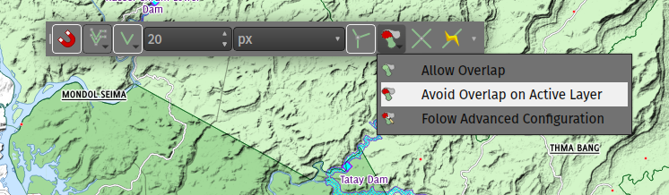
この機能は OpenGIS.ch によって資金提供されました
この機能は Mathieu Pellerin によって開発されました
機能: 新スナップモード: 重心とセグメントの中央(midpoint)
この機能は、CADツールの体験に近づくことで、QGISのスナッピングモード を改善することを目指しています。
ジオメトリの中心(重心)とセグメントの中央にスナップする2つの新しいモードを追加します。
これらの新しいモードが選択できることで、複数のスナップモードを同時に選択することができます。
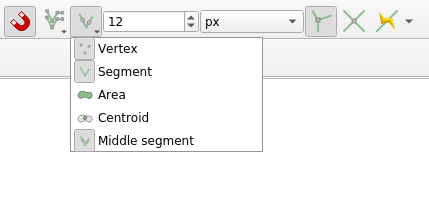
スナップする優先順位は次のとおりです: 頂点、交点、中央、重心、辺、領域
後援: Qwat group / Ville de Lausanne ( @ponceta @dsavary ) / Oslandia そして少しの空き時間
この機能は lbartoletti によって開発されました
機能: デジタイズしている地物にスナップする
スナップは、デジタイズ中の地物へのスナップにも対応するようになりました。このオプションは、スナップツールバーの新しいボタンで有効/無効にできます。
これにより、CADのように精密な編集機能が使えます。例えば、地物を90°の角度で閉じたり、地物内のセグメントを正確に整列させたりすることができます。角度をロックするのにalt+aショートカットを使用することに慣れれば非常に効率的です。

この機能は Kanton Solothurn and Land Vorarlberg によって資金提供されました
この機能は Olivier Dalang によって開発されました
機能: トレースは曲線ジオメトリに対応しました
曲線ジオメトリをサポートするレイヤで作業する際に、トレーシングツールは曲線ジオメトリを作成します。

このサポートはまだ実験的ですので、この機能はデジタイズオプションで有効にする必要があります。
この機能は ecoptima and Planteam によって資金提供されました
この機能は Olivier Dalang (OPENGIS.ch) によって開発されました
フォームとウィジェット
機能: ファイルウィジェットにあるリンクを編集できる
フォームで、(ウィジェットが読み取り専用でない場合、)ファイルウィジェットでリンクを編集することができます。
QGISスイスユーザーグループ によって後援されました
この機能は Denis Rouzaud によって開発されました
機能: 式で制御されたラベル(別名)
この新しい機能により、フォームのラベル(別名)をフォームの文脈で評価することができます。
この機能は ARPA Piemonte によって資金提供されました
この機能は、 Alessandro Pasotti によって開発されました
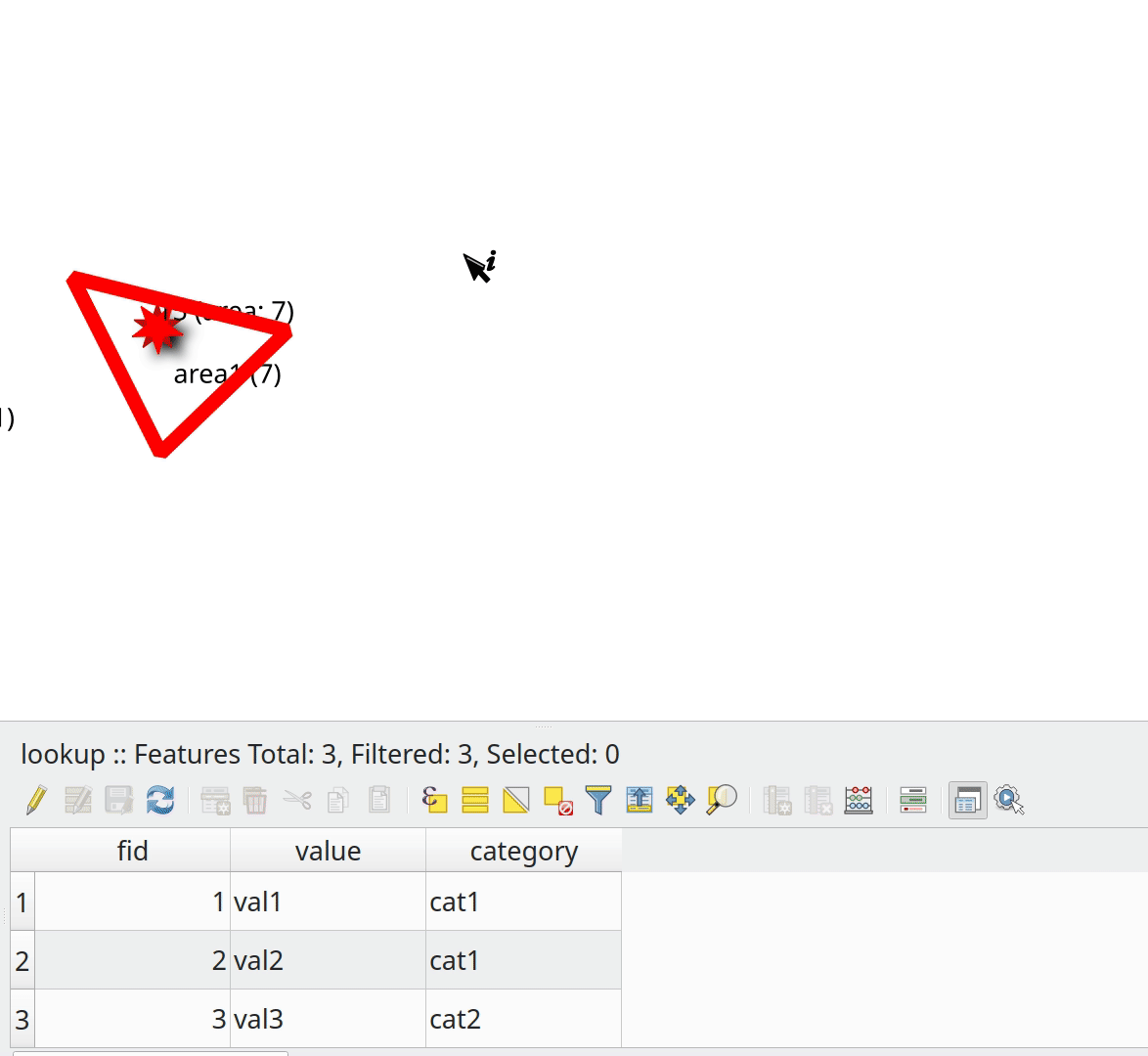
機能: 値のリレーションウィジェットに説明を追加
値のリレーションウィジェットにある各値に説明を追加するオプションを追加します。説明はツールチップとして表示されます
デモビデオの変わった言語をお許しください。
この機能は Matthias Kuhn によって開発されました
機能: 新しいデータベーステーブル名ウィジェット
既存のDB接続から新しいテーブルを選択する新しいウィジェットがQGISに追加されました:
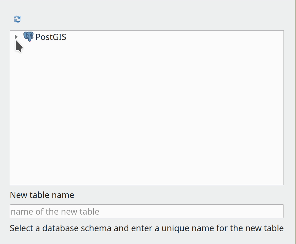
この機能は Alessandro Pasotti によって開発されました
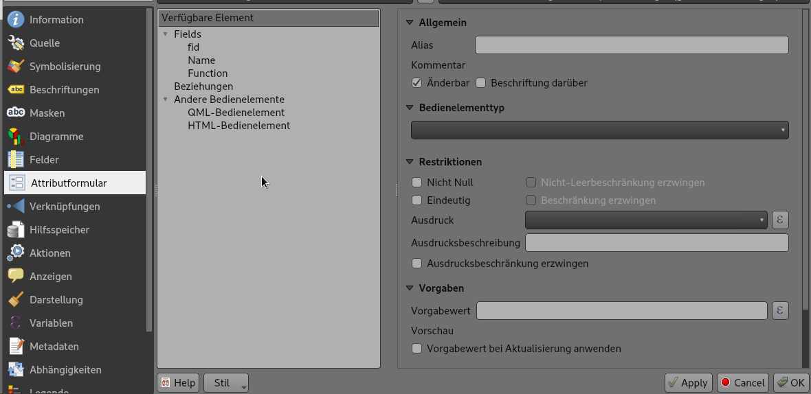
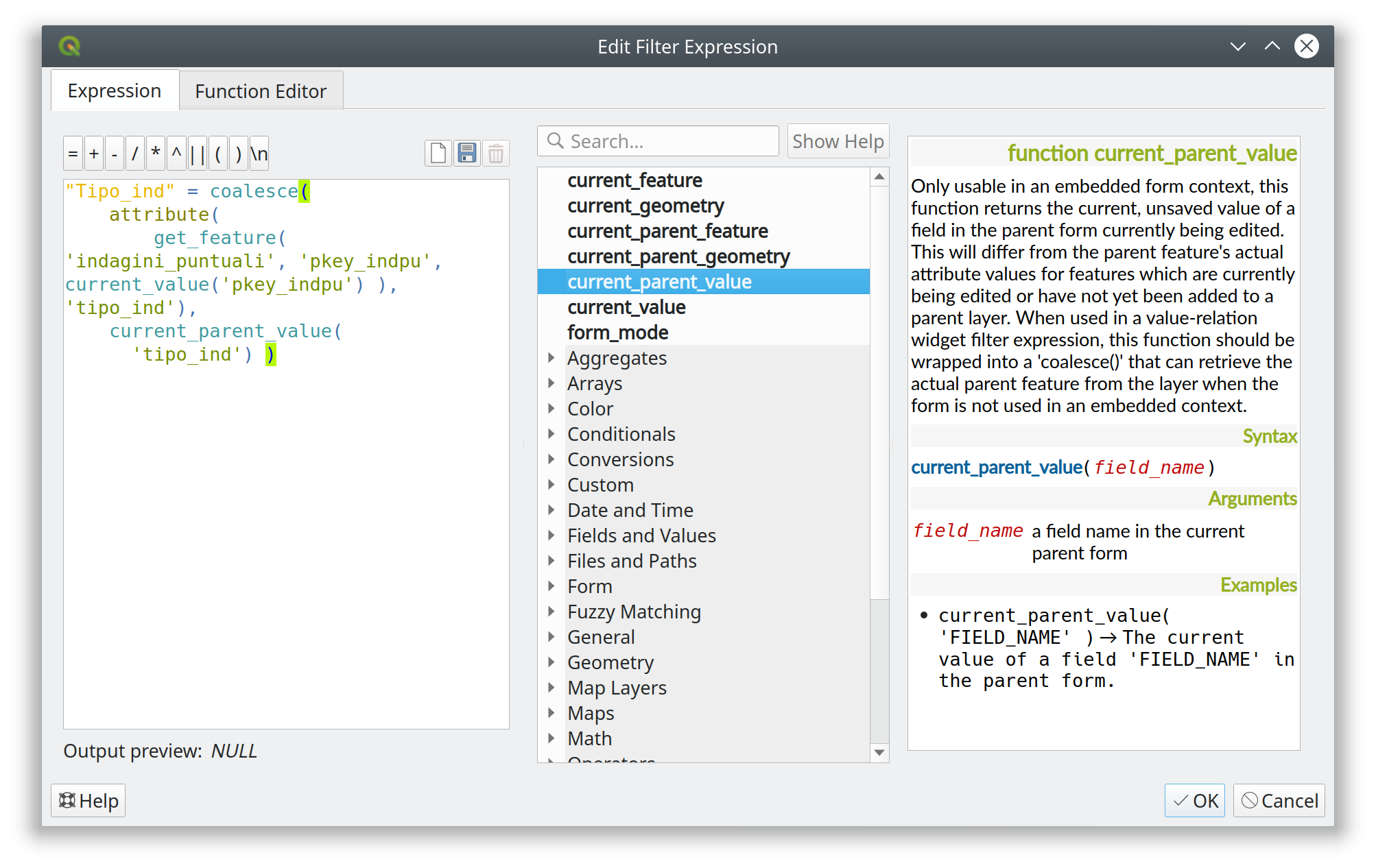
機能: 子フォームで現在の親フォームの値を取得する
この機能は、フィルタ式で「親」フォームの現在の値を使用するオプションを追加します(現時点では値リレーションウィジェットのみ: ドリルダウンフィルタで使用されます)。
埋め込まれた子フォーム内から親にアクセスするための新しい関数と変数のセットと、新しい "parentForm" 範囲が追加されました。新しい関数と変数は既存の "current_value"、"current_feature" などをモデルにしています。
新しい機能と変数は、親フォームが新しい(保存されていない、バッファされていない)地物から開かれた場合にも利用可能であり、保存されていない親フォームから子を追加する際に親の値に基づいたドリルダウンフィルタを作成することが容易になります。
例
新しい関数と変数
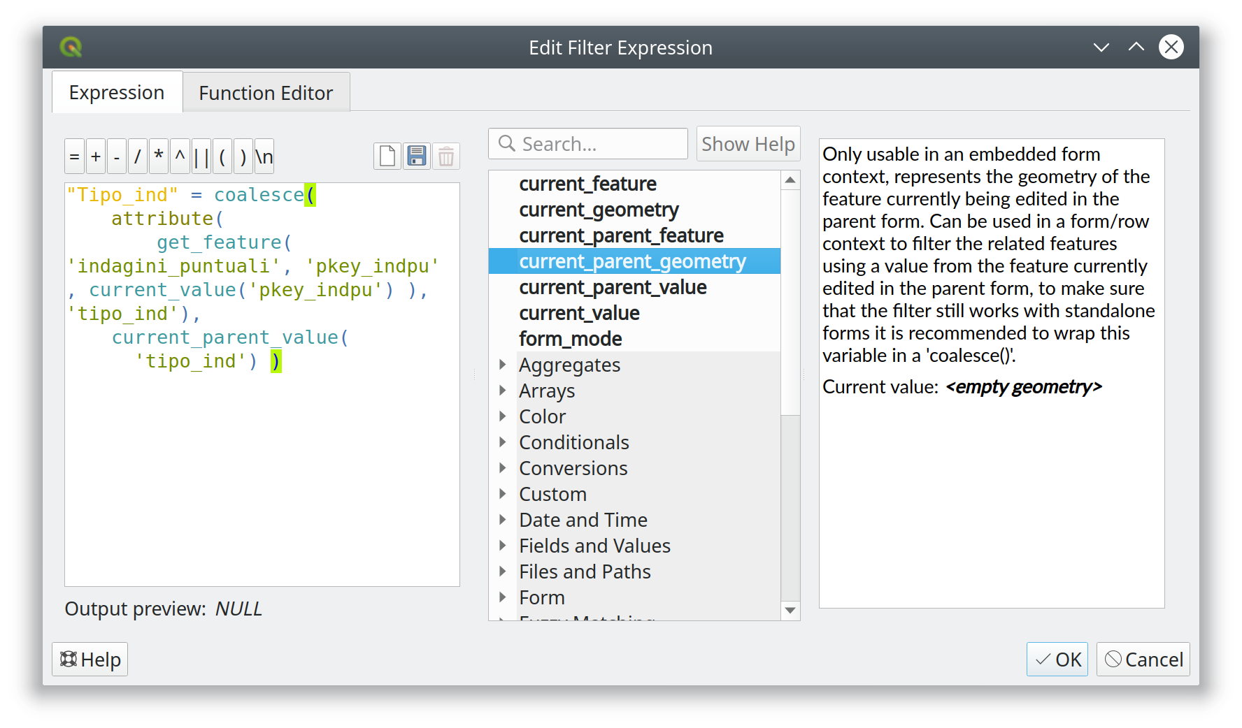
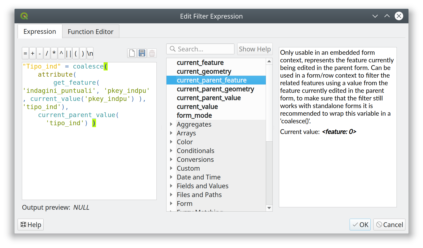
資金提供: ARPA Piemonte
この機能は ARPA Piemonte によって資金提供されました
この機能は、 Alessandro Pasotti によって開発されました
機能: リレーションウィジェット: 保存子編集ボタンを非表示にするチェックボックスを追加
これは埋め込みフォームに非常に便利です。
資金提供: ARPA Piemonte
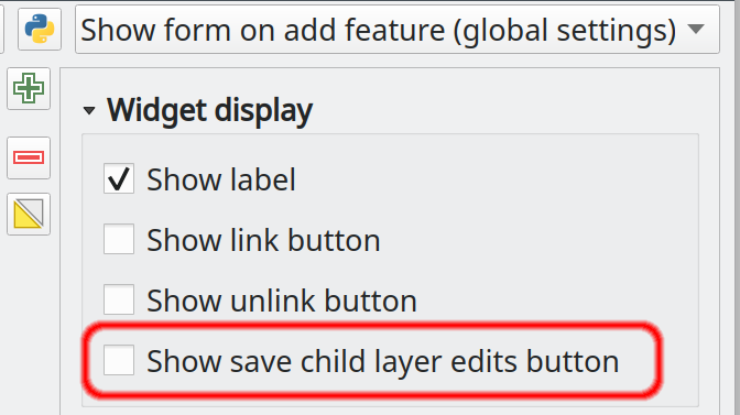
この機能は ARPA Piemonte によって資金提供されました
この機能は、 Alessandro Pasotti によって開発されました
機能: リレーションウィジェットはポップアップの抑制を強制します
リレーションウィジェットの設定に、埋め込みフォームコンテキストで新しい地物が追加されたときにフォームのポップアップを抑制するオプションを追加します。
このオプションは、(フォームがスタンドアロンのフォームとして使われる場合に依然として望ましい動作である可能性がある)フォームレベルのオプションを上書きします。
注意: 最終的なラベルは 地物の追加時にフォームを強制的に非表示にする
この機能は ARPA Piemonte によって資金提供されました
この機能は、 Alessandro Pasotti によって開発されました
レイヤー凡例
機能: 選択したレイヤ>=2の場合、グループ追加ボタンをグループ選択とする
ひとつ以上のレイヤが選択されていて、グループ追加 ボタンを押したとき、新しいグループが作成され、選択されたレイヤもそれに含まれます! 
この機能は uclaros によって開発されました
機能: 現在のマップテーマの名前を変更できる
このオプションは、マップテーマのドロップダウンメニューからマップテーマの名前を変更する機能を追加します。
この機能は Harrissou Sant-anna によって開発されました
機能: 「スペース」 ボタンで選択された全てのレイヤをオン/オフにする
選択されているレイヤまたはグループの表示/非表示をスペースボタンで切り替えます: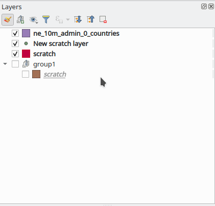
この機能は Ivan Ivanov によって開発されました
分析ツール
機能: ネットワークロガー - より多機能
ネットワークロガーにいくつかの便利なツールを追加します:
URLをコピー
JSONとしてリクエストをコピー
ログをファイルに保存(ログには機密情報が含まれている可能性があり、機密扱いされるべきであるとユーザーに大きな警告を表示した後)
この機能は Nyall Dawson によって開発されました
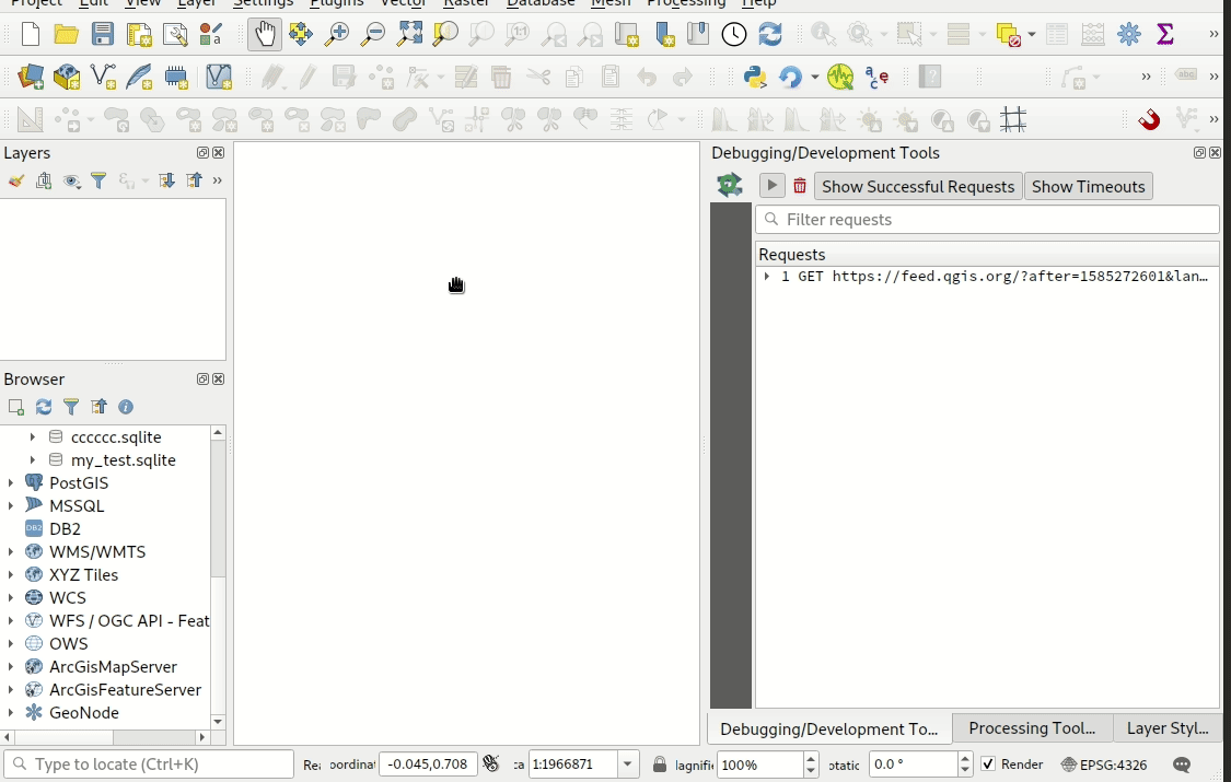
機能:組み込みのネットワークログツール
このツールは、新しいF12「開発ツール」パネルから利用できるもので、@rduivenvoordeのネットワークロガープラグインのネイティブポートです。
進行中および完了したネットワークリクエストのリストと、ネットワークのリクエストとリプライの状態、ヘッダー、エラー、SSL設定エラー、タイムアウト、キャッシュの状態など、非常に便利な詳細が表示されます。
また、URLの部分文字列とステータスでリクエストをフィルタする機能など、多くのポリッシュと便利な機能があり、また、リクエストを右クリックしてURLをブラウザで開くか、cURLコマンドとしてコピーすることができます。
なぜプラグインではなく、ネイティブツールとしてこれを望むのか?それは次のような理由です
非常に便利なので、そのまま使えるのは嬉しい
c++に移動することで、プラグインが機会を得る前にログ処理を開始することができます。これにより、ネットワークロガープラグインがロードされる前に発生する他のプラグインによって発生するリクエストなどの追加情報をログに含めることができます(また、他の組み込みリクエスト、例えばニュースフィードなど)。
パフォーマンスは、Pythonプラグインとの継続的な闘争です。これは可能な限り1:1のポートに近いものですが、パフォーマンスの問題はすべて魔法のように解決されています。クラスには非常に集中的なリスト操作がいくつかあります。これは、Pythonでのパフォーマンス低下の原因である可能性があります。
この機能は Meteorological Service of Canada によって資金提供されました
この機能は Nyall Dawson (for Kartoza) によって開発されました
プロセシング
機能: 乱数ラスタ生成アルゴリズムのコレクション
この機能により、乱数ラスタ生成アルゴリズムの大規模なコレクションが追加されました。これらのアルゴリズムは、特定の乱数分布に従って乱数ラスタを出力することができます。以下の分布が利用できます:
乱数ラスタの作成(二項分布)
乱数ラスタの作成(指数分布)
乱数ラスタの作成(ガンマ分布)
乱数ラスタの作成(負の二項分布)
乱数ラスタの作成(正規分布)
乱数ラスタの作成(ポワソン分布)
乱数ラスタの作成(一様分布)
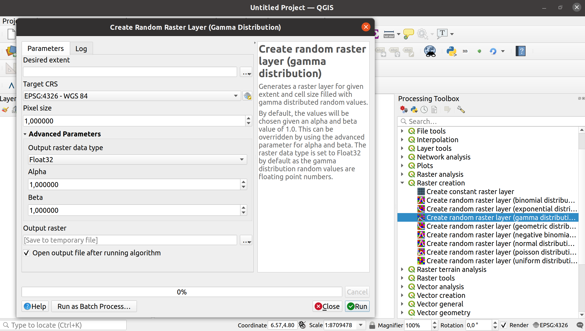
この機能は Clemens Raffler によって開発されました
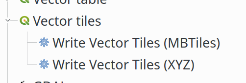
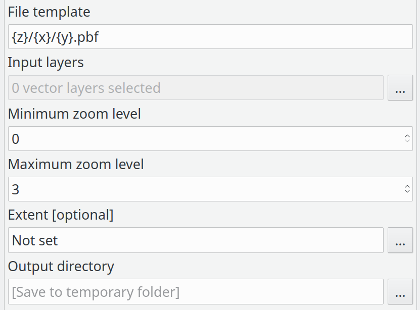
機能: ベクタタイルレイヤ - パート8(プロセシングのライタ)
この機能は、ベクタータイルを書き出すためのプロセシングの統合を追加します。これは既存のQgsVectorTileWriterクラスのラッパーにすぎません。
プロセシングツールボックスの新アルゴリズム:
XYZのためのアルゴリズムのパラメータ:
MBTilesのためのアルゴリズムのパラメータ
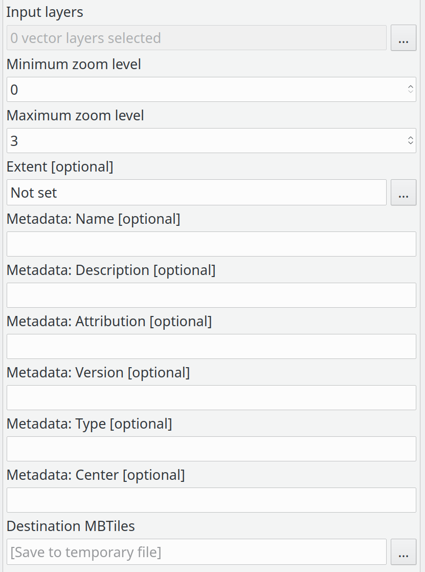
入力レイヤのリスト:
入力レイヤの詳細:
この機能は QGIS Community によって資金提供されました
この機能は Lutra Consulting (Martin Dobias) によって開発されました
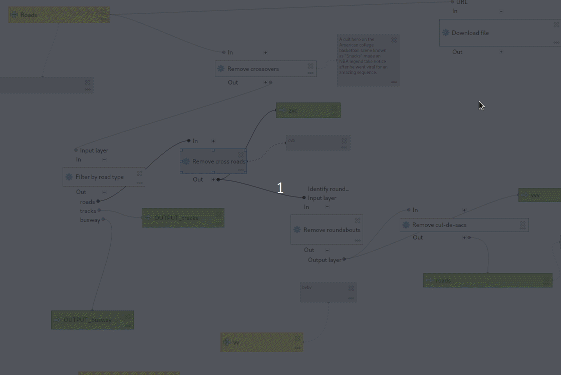
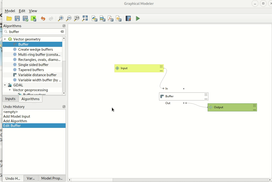
機能: 条件分岐を作成するための新しいモデラーアルゴリズム
このアルゴリズムによって(QGIS式を介した)複数の条件が設定できるようになり、式の評価結果に応じてモデルの対応する枝が実行されるかスキップされます。
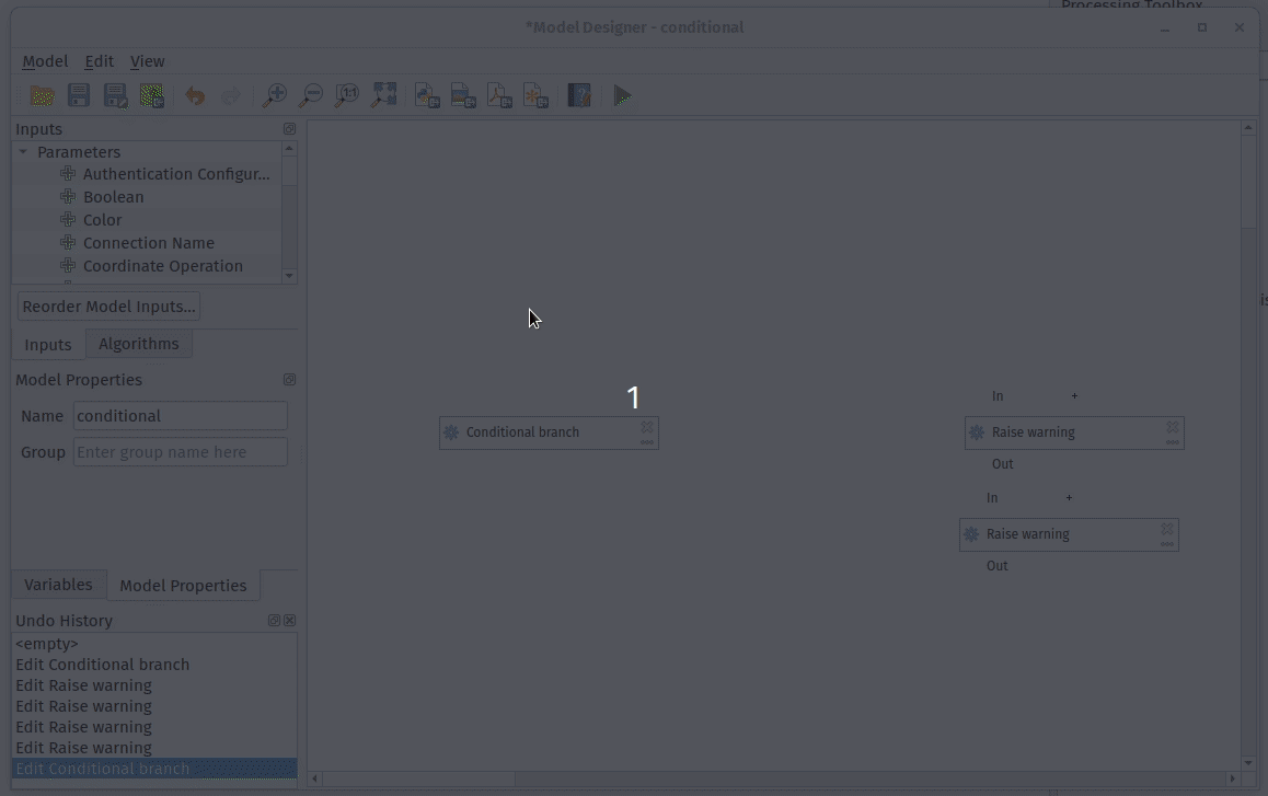
この機能はAndreas Neumannによって資金提供されました
この機能は Nyall Dawson によって開発されました
機能: モデルの入力を並び替えられる
この機能は、モデルの入力の外見上の順不同を強制する代わりに、モデルデザイナーの新しい「モデル入力の並べ替え」オプションを見えるようにします。これにより、ユーザーは入力の正確な順序を制御して、モデルを表示できます。
フィールドの選択がそれに基づくレイヤの選択よりも前に表示されるような、非論理的な順序はもうありません!
NaturalGISによって後援されました
この機能は Nyall Dawson によって開発されました
機能: モデルの検証を延期
全ての子アルゴリズムを即座に有効とし、全てのパラメータが正しく入力されていることを強制する代わりに、この機能はモデルの検証を実行時または新しい「モデルの検証」アクションがトリガーされるまで延期します。
QGISモデルデザイナーの一般的な不満点は、モデルの作成中であっても、常にモデルが有効であることを強制されることです。これは、モデルにコンポーネントを追加し、その設定を一部だけ入力することが不可能であること-全ての設定を最初から埋める必要があることを意味します。もしモデルのどこかで変更が必要なことに気づいたとき、既に設定した全ての設定を取り消して失うことなく変更することは不可能です。
この変更では、モデルの検証が実行時まで延期されます。モデルは一時的に無効になる場合があります(例:部分的に構成されたアルゴリズムコンポーネントを持つ場合)。必要な値が不足している場合、既存の設定を失うことなく後で埋めることができます。有効でないモデルを実行すると、モデルの構成を完了するために変更が必要なことを示す説明的な警告が表示されます。
この機能は Nyall Dawson によって開発されました
機能: 定数ラスタを作成アルゴリズムに別のラスタデータ型のサポートを追加
この機能により、定数ラスタを作成 アルゴリズムの新しい高度な OUTPUT_TYPE パラメータが追加されました。このパラメータを使用することで、定数ラスタレイヤの出力データ型を指定できます。
Byte
Integer16
Unsigned Integer16
Integer32
Unsigned Integer32
Float32
Float64
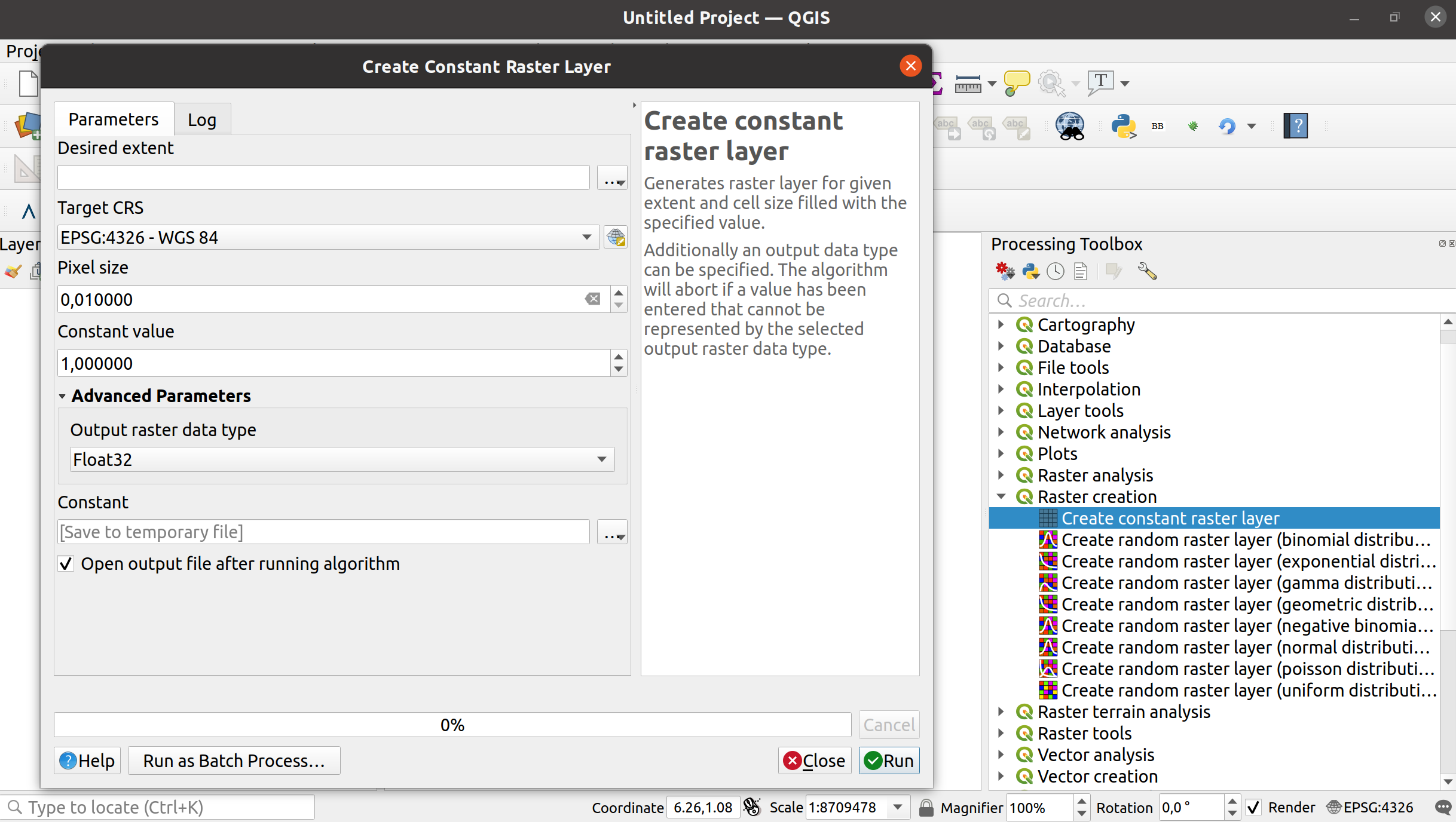
この機能は Clemens Raffler によって開発されました
機能: ラスタ値を四捨五入アルゴリズムを追加
この新しいプロセシングアルゴリズムにより、QGISで ラスタの値を丸める ことができます。
このアルゴリズムの主な機能は、浮動小数点セル値の標準のアップ/ニアレスト/ダウン丸め、またはユーザー指定の底 n の累乗への丸めです。このアルゴリズムは、すべてのタイプのラスタ(nのべき乗に丸めた場合はバイト/整数ラスタも含む)で使用でき、同じラスタデータタイプを出力します。整数ラスタの標準的な浮動小数点丸めは、それをコピーして警告を出します。
この例では10の倍数に丸められた出力ラスタを示しています
この機能は Clemens Raffler によって開発されました
機能: モデル要素をコピー/切り取り/貼り付けできる
この機能を使うと、モデル要素を同じモデル内および異なるモデル間でコピーして貼り付けることができます
Refs NRCan Contract#3000707093
この機能は Nyall Dawson によって開発されました
機能: 既存のレイヤにプロセシングの結果を追加できる
結果を追加する際、フィールドマッピングパネルの選択肢を与えられ、フィールドが宛先レイヤのフィールドにどのようにマッピングされるかを手動で設定することができます。
Refs NRCan Contract#3000707093
この機能は Nyall Dawson によって開発されました
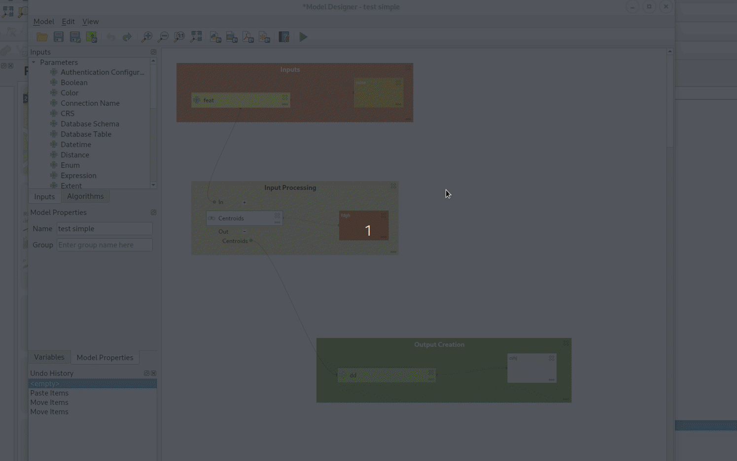
機能: モデルでグループボックスを作成できる
モデルデザイナーに以下の機能を追加します:
モデル内の個々のコメントの色をカスタマイズする機能
モデル内で、論理的にリンクされたモデル要素の視覚的な表示である「グループボックス」が作れます(例「データの準備段階」、「NDVI計算段階」など)。ユーザーはグループボックスの色と表題をカスタマイズできます。
ビューメニューからグループボックスへ直接移動でき、複雑なモデルの移動を助けます。
Refs NRCan Contract#3000707093
この機能は Nyall Dawson によって開発されました
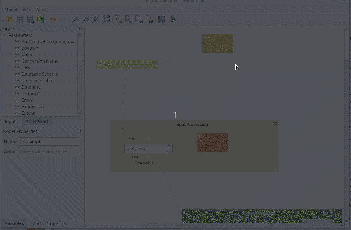
機能: プロセシング: デザイナーからモデルを実行した後、子供の入力値と出力値を表示
図が最もわかり易く説明しています!デザイナーからアルゴリズムを実行した後、各子アルゴリズムのために計算された入力と出力の値が分かります:
これはデバッグするために非常に役立ちます - モデル内の値のフローをより明確で視覚的なイメージを見ることができます。
Refs NRCan Contract#3000707093
この機能は Nyall Dawson によって開発されました
機能: モデルに「ログをファイルに保存」アルゴリズムを追加
このアルゴリズムは、実行ログの内容('save log'アルゴリズムが実行されるモデル内のポイントまで)をファイルに保存します。
後で参照したり透明性のために、モデルを実行する際にデバッグログを自動的に保存するのに使うことができます。
Refs NRCan Contract#3000707093
この機能は Nyall Dawson によって開発されました
機能: プロジェクトに読み込まずに、データベース(およびその他の非ディスク)のソースでアルゴリズムを直接実行できる
この変更により、ユーザーはプロセシング機能の入力としてディスクベースではないレイヤソースに直接ブラウズできるようになります。これにより、これらの入力をプロジェクトに最初に読み込むことなく、postgres、sql server、oracle、wfs、afsなどのレイヤに直接アクセスできます!
QGISブラウザをフルに活用して、これを可能にします:
Refs NRCan Contract#3000707093
この機能は Nyall Dawson によって開発されました
機能: プロセシング入力の高度なオプション「地物ソースごと」を見えるようにする
この機能は、高度なオプション「地物ソースごと」を次のように見えるようにします:
ソースから読み込む地物の数を制限する機能。 (モデル開発に便利で、入力レイヤの小さなサブセットを使ったモデルのテスト実行を簡単に行うことができます)
入力ごとに、無効なジオメトリを処理する方法のグローバル処理オプションをオーバーライドする機能。これで、デフォルトの処理設定を控えめな「ジオメトリが無効な場合はアルゴリズムの実行を停止する」設定のままにして、特定の入力に対して一時的にこれを簡単にオーバーライドできます。
Refs NRCan Contract#3000707093
この機能は Nyall Dawson によって開発されました
機能: デザイナーでモデルをグリッドにスナップできる
This update implements two "snapping" features in the Processing model designer:
Users can enable a new "Enable Snapping" option from the view menu, which will cause all component moving or resizing operations to automatically snap to grids
After selecting some components, users can select Edit -> Snap Selected Components to Grid to manually snap just those selected components.
Additionally, I've added a helpful "select all" action for quickly selecting all components in a model.
Refs NRCan Contract#3000707093
この機能は Nyall Dawson によって開発されました
機能: プロセシングに「ジオメトリ型でフィルタ」および「レイヤ型でフィルタ」アルゴリズムを追加
This update adds two new algorithms to processing:
"Filter by geometry type": This algorithm filters features by their geometry type. Incoming features will be directed to different outputs based on whether they have a point, line or polygon geometry. It allows for model creation which responds to different input layer geometry types by applying different logic depending on the input geometry type.
"Filter by layer type": This algorithm allows conditional model branching based on an input layer type. For instance, it allows a model to adapt to the actual layer type of a generic "map layer" parameter input, and decide which branch of the model to run as a result.
また、必要なAPIを追加して、アルゴリズムが計算結果に基づいてモデルブランチを「枝刈り」できるようにします。たとえば、新しい FlagPruneModelBranchesBasedOnAlgorithmResults フラグを返すモデルでは、アルゴリズムがその特定の出力を返さない場合、そのアルゴリズムの出力に依存するモデルの残りの部分は完全にスキップされます。 (これは、将来の一般的な「式による条件付き分岐」アルゴリズムの前提条件コンポーネントであり、「レイヤータイプによるフィルタ」によって使用され、入力レイヤータイプに基づいてモデルフローを制御します)
Refs NRCan Contract#3000707093
この機能は Nyall Dawson によって開発されました
機能: 「NULLジオメトリを削除」アルゴリズムは、EMPTY ジオメトリも削除できます
空のジオメトリには座標が含まれていません。したがって、 null ジオメトリのように、空のジオメトリは厳密な意味での空間データではありません。ユーザーがベクターレイヤーを簡単にクリーンアップできるように、 NullGometriesの削除 アルゴリズムに[ 空のジオメトリも削除 ]オプションが追加されました。
この機能は SwissTierras Colombia によって資金提供されました
この機能は Germán Carrillo によって開発されました
機能: モデルデザイナーに複数選択の処理を追加、対話的なサイズ変更
追加:
モデルデザイナーで複数の項目を一度に選択する機能
個々の又は複数の項目の大きさを変える機能
選択された複数の項目を削除する機能
Improved model designer "tool" interaction, following the layout designer approach (e.g. alt + space = zoom drag mode, and selection tools follow their counterparts in layouts so shift+selection adds to selection, ctrl+selection removes, etc)
選択された項目はカーソルキーで移動できます
Refs NRCan Contract#3000707093
Here's how it looks in action (with a particular ugly looking test model I use!)
この機能は Nyall Dawson によって開発されました
機能: モデルデザイナーに元に戻す/やり直す対応を追加
QGISを利用者にもっと寛大にします!
Refs NRCan Contract#3000707093
期待したように動作します:
影響を受けるコンポーネントの変更だけでなく、全体のモデル定義を「元に戻す」スタックに保存していることに注意してください。
この機能は Nyall Dawson によって開発されました
機能: モデルデザイナーの実行の後でもパラメータ値を保存
モデルを設計する際、ユーザーは通常、構造を微調整しながらモデルを何度も実行する必要があります。
この変更により、デザイナーからモデルを実行する際に使用されるパラメータが記憶され、モデルに保存されるため、デザイナーからモデルを実行するたびに、すべての入力パラメータの値を再設定する必要がありません。
反復的なモデルの設計がとても簡単になります!
Alta Ehf によって後援されました
また、c++ >> Python なので、モデルデザイナーダイアログの一部がPythonからc++に移植されています。
この機能は Nyall Dawson によって開発されました
機能: プロセシングモデルのコメント
This allows users to create comments attached to model components (inputs, algorithms or outputs). Comments are shown linked to the associated component, and can be freely moved around the model.
Fisel + König によって資金提供されました
この機能は Nyall Dawson によって開発されました
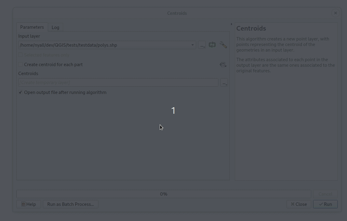
機能: プロセシングアルゴリズムを実行するための新しいスタンドアロンコンソールツールを追加
This new qgis_process tool allows users to run processing algorithms (both built-in, and those provided by plugins) directly from the console.
Running:
qgis_process listwill output a complete list of all available algorithms, grouped by provider.qgis_process pluginslists available and activated plugins which advertise the hasProcessingProvider metadata option (only these plugins are loaded by the tool)qgis_process help algidoutputs the help and input descriptions for the specified algorithm, e.g.qgis_process help native:centroids
qgis_process run: runs an algorithm. Parameters are specified by a --param=value syntax. E.g.
qgis_process run native:centroids --INPUT="my_shapefile.shp" --OUTPUT="centroids.kml"
または
qgis_process run native:buffer --INPUT=/home/me/my.shp --DISTANCE=20 --OUTPUT=/home/me/buffered.shp
While running an algorithm a text-based feedback bar is shown, and the operation can be cancelled via CTRL+C
Swedish User Group によって後援されました
この機能は Nyall Dawson によって開発されました
機能: 日時(または日付または時刻)値の新しいパラメータ型
Adds a new parameter type QgsProcessingParameterDateTime for handling date/datetime/time values.
この機能は Nyall Dawson によって開発されました
機能: モデルから警告と例外を発生させるためのアルゴリズムを追加
These algorithms raise either a custom warning in the processing log OR raise an exception which causes the model execution to terminate.
An optional condition expression can be specified to control whether or not the warning/exception is raised, allowing logic like "if the output layer from another algorithm contains more than 10 features, then abort the model execution".
Fisel + König によって後援されました
この機能は Nyall Dawson によって開発されました
機能: NoDataセルを指定値で埋めるアルゴリズムを追加
In the new QGIS version we introduce a new processing algorithm for filling NoData cells in a raster dataset with a constant numerical input.
The algorithm scans an input raster dataset for NoData cells and fills them with the user defined fill value. Doing so, the algorithm respects the data type of the input raster so that e.g. floating point numbers will be dealt with appropriately for an integer raster. The resulting dataset will not contain any NoData cells.
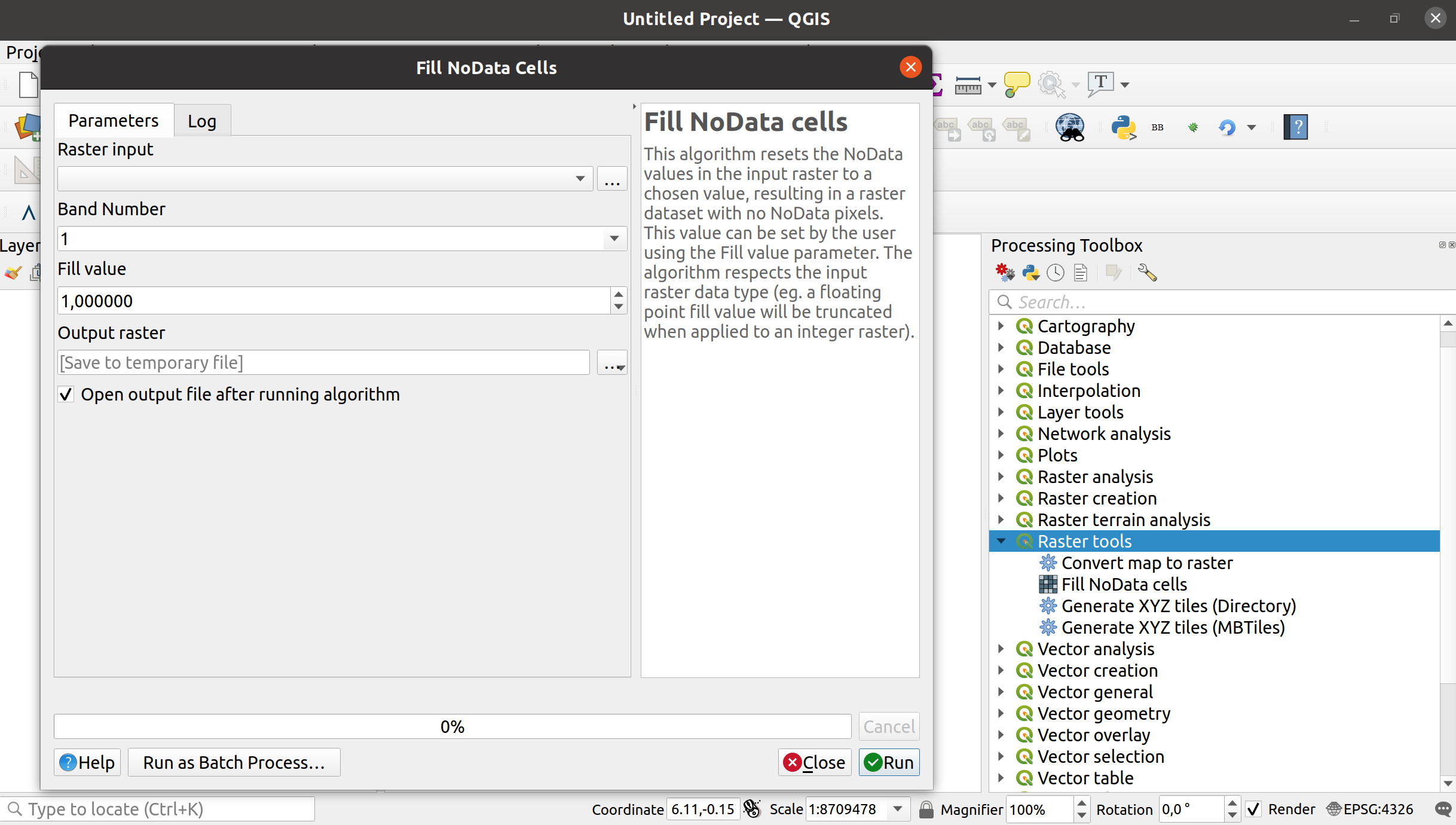
この機能は Clemens Raffler によって開発されました
機能: プロセシングのための様々な修正
Finalize work on range parameters support in GRASS algorithms;
Fix broken r.series algorithm
Minor fixes to r.rescale and r.rescale.eq
Fix for rasterize tool
GRASS GIS tests cleanup
この機能は Alexander Bruy によって開発されました
機能: 「テンプレートレイヤ」のフィールド制約を「属性をのリファクタリング」アルゴリズムのインタフェースに表示
When you are migrating data, it is important to be aware of constraints on target (a.k.a. template) layers.
The "Refactor Fields" algorithm now highlights constraints, and even lets you know more about them via tool-tips.
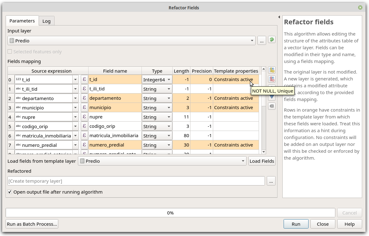
この機能は SwissTierras Colombia によって資金提供されました
この機能は Germán Carrillo によって開発されました
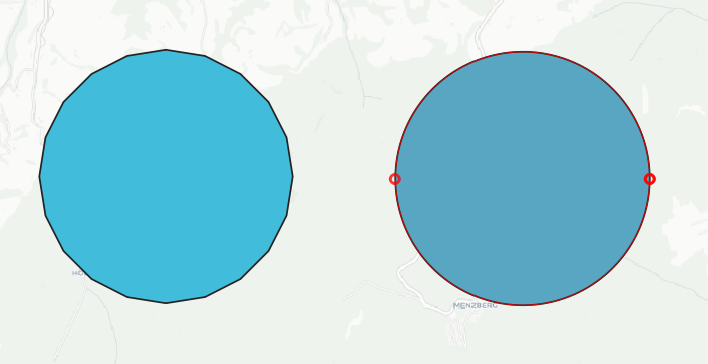
機能: 新しい曲線に変換アルゴリズム
We added a new algorithm to convert segmentized geometries to curved geometries.
The algorithm considers successive points to represent a curve if they are evenly spaced and within a tolerance.
この機能は Nyall Dawson によって開発されました
アプリケーションとプロジェクトのオプション
機能: @layers, @layer_ids プロジェクトスコープ変数の追加
Add @layers, @layer_ids project scope variables which contain lists of map layers and map layers ids for all layers from the current project
This mimics the existing @map_layers, @map_layer_ids, but unlike the @map variants these return ALL project layers, not just those associated with the current context's map settings.
SLYRによって後援されました
この機能は Nyall Dawson によって開発されました
データプロバイダ
機能: 新しいスクラッチレイヤダイアログで属性を追加できる
Allows the user to add attributes directly in the New Scratch Layer dialog making it more consistent with other dialogs like New Shapefile/Geopackage. 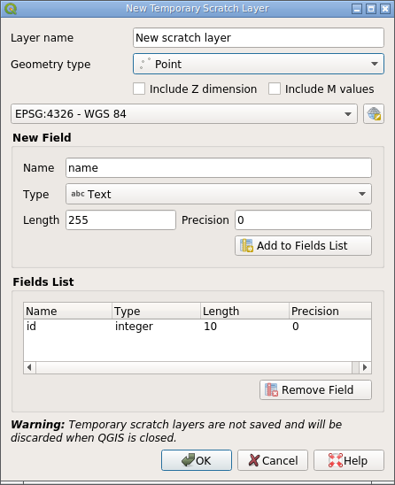
It is still possible to create a scratch layer without any attributes by not adding any fields to the list.
この機能は Alexander Bruy によって開発されました
機能: 新しいシェープファイルダイアログからジオメトリのないDBFテーブルを作成できる
Allow creating "plain" DBF files without associated geometries from the New Shapefile dialog.
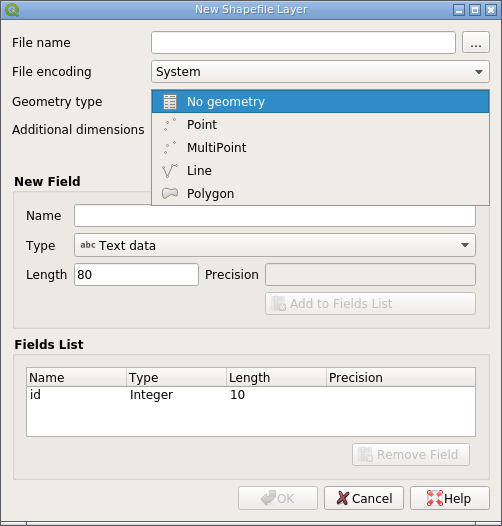
Creating DBF tables can be useful in some cases and having to use third-party tools for this instead of doing it from within QGIS is inconvenient. This also makes the New Shapefile dialog more consistent with the New Geopackage dialog, which already allows "geometryless" tables to be created.
この機能は Alexander Bruy によって開発されました
機能: ソースダイアログでWM(T)Sリストをフィルタできる
Add ability to filter between lists of WMS or WMTS from the source dialog
WMS 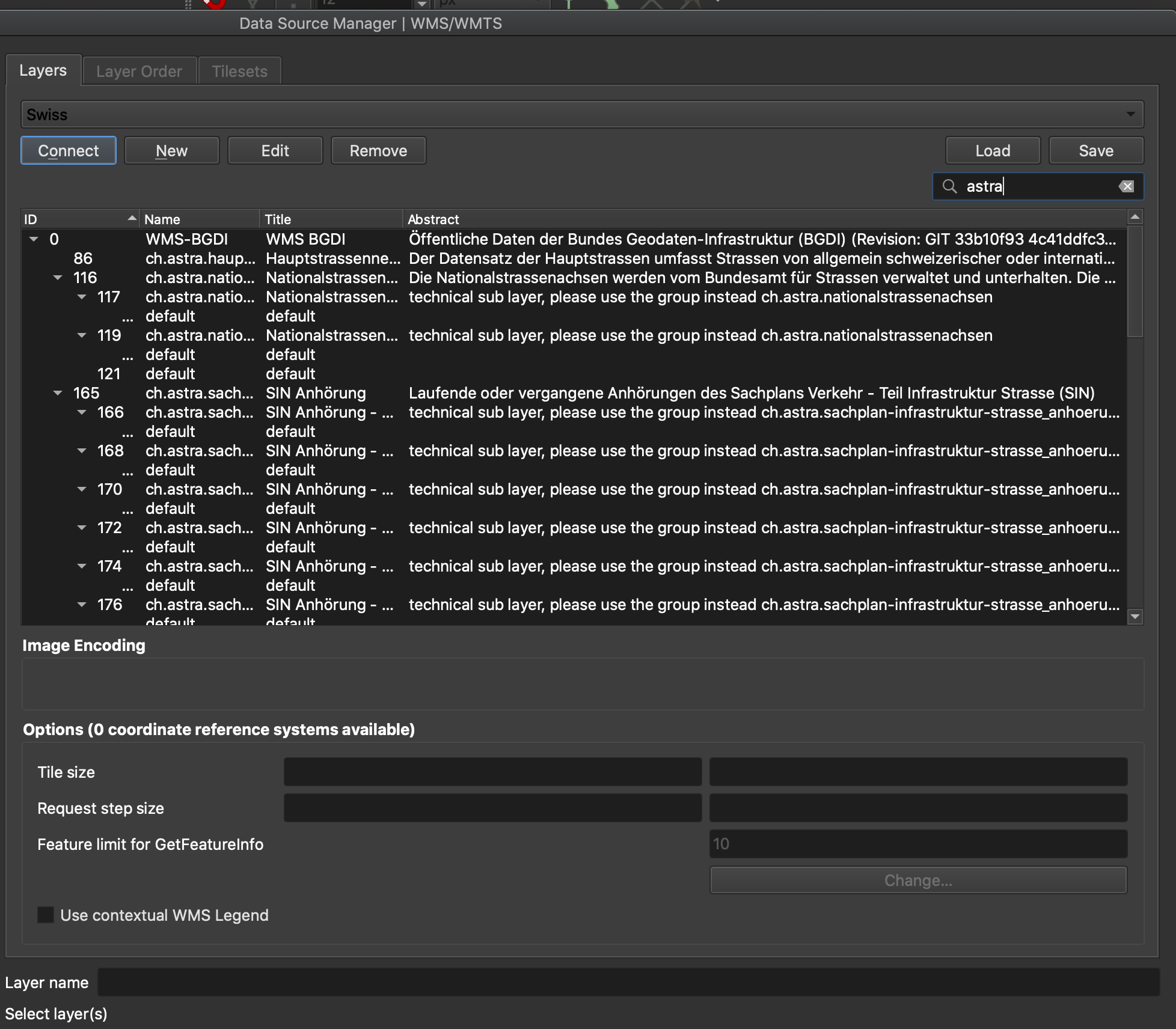
WMTS 
QGISスイスユーザーグループ によって後援されました
この機能は Denis Rouzaud によって開発されました
機能: ArcGIS MapとFeatureServer接続のインポート/エクスポート
Add missed import/export functionality for ArcGIS MapServer and FeatureServer connections.
この機能は Alexander Bruy によって開発されました
機能:SpatiaLiteのトランザクショングループ
Transactions implementation for the native SpatiaLite provider.
この機能は ARPA Piemonte によって資金提供されました
この機能は、 Alessandro Pasotti によって開発されました
Feature: Allowing saving outputs direct to more database formats (and other nice stuff)
This update allows users to save processing vector outputs directly to more database formats.
Previously outputs could only be written directly to postgres databases. With this change, this functionality has been made more flexible and now supports direct writing to any database provider which implements the connections API (currently postgres, geopackage, spatialite and sql server)
Ultimately this exposes the new ability to directly save outputs to SQL Server or Spatialite databases (alongside the previous GPKG+Postgres options which already existed)
(As soon as oracle, db2, ... have the connections API implemented we'll instantly gain direct write support for those too!)
We do this via a nice inline version of the new "new database table name" widget.
Other nice stuff includes:
You can now drag and drop file or folders from explorer or the qgis browser to output parameters in order to easily overwrite these files (or save to the folder), matching the behavior possible with inputs
You can actually write scripts which output direct to ANY qgis data provider (including oracle and db2)... it's just that these don't get exposed in the UI because they don't yet support the connections API
Refs NRCan Contract#3000707093
この機能は Nyall Dawson によって開発されました
機能: データベース接続に専用のパラメータ型を追加
Allows selection from the registered database connections for a specific database provider type (the provider must implement the connections API).
Refs NRCan Contract#3000707093
この機能は Nyall Dawson によって開発されました
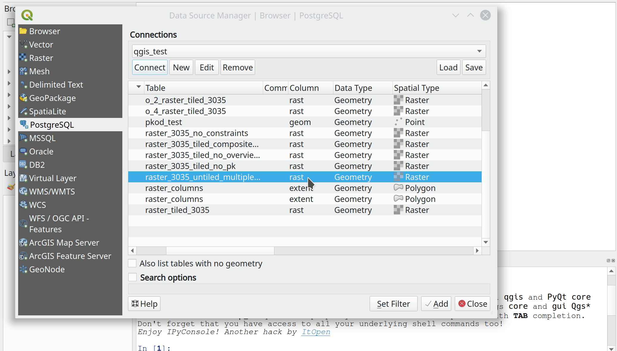
機能: PG: 外部テーブルを見えるようにする
Expose foreign tables to the browser and data source select dialog.
この機能は Alessandro Pasotti によって開発されました
Feature: PG raster expose set filter to app
This should be the final change to the PG raster data provider and exposes the set filter options:
Filter can be set in the data source dialog (as for vector layers)
Filter can be set from the legend tree's context menu (as for vector layers)
The renderer, the extent and the min/max stats are also updated when the filter changes
New tests for the new behavior
この機能は ARPA Piemonte によって資金提供されました
この機能は、 Alessandro Pasotti によって開発されました
機能: Postgres: 地物を生成されたフィールドと共にテーブルに保存する
Allow updating/inserting features in PostgreSQL tables with generated fields. GENERATED columns is a feature introduced by PostgreSQL 12, which allows column values to be generated from other columns in the same table; this replaces the creation of triggers to, for instance, automatically populate and keep up-to-date a column of centroids or areas for the polygons in the main geometry column.
この機能は José de Paula Rodrigues N. Assis によって開発されました
Feature: Date and DateTime field types support added to Spatialite and Delimited Text providers
The Spatialite and Delimited Text providers now support Date and DateTime field types.
この機能は Mathieu Pellerin によって開発されました
QGISサーバー
機能: QGIS_SERVER_IGNORE_BAD_LAYERS 設定オプションを追加
Allows the overriding of the default behavior in the case of bad layers (which is to invalidate the whole project).
When set to TRUE, bad layers are skipped and the remainder of the project becomes available.
この機能は Geoinformatikbüro Dassau GmbH によって資金提供されました
この機能は、 Alessandro Pasotti によって開発されました
Feature: Server project settings, add 'expanded' attribute
この更新では、「visible」および「mutuallyExclusive」属性に加えて、サーバーのGetProjectSettings応答に「expanded」が追加されます。この更新により、Webクライアントは、どのレイヤーツリー要素が展開/折りたたまれているかを確認し、それらをWebマップレイヤーリストに同じように表示できます。
この機能は mhugent によって開発されました
機能: DXFサーバーエクスポートパラメータ NO_MTEXT と FORCE_2D を追加
QGIS server now supports the new parameters NO_MTEXT and FORCE_2D to control text and line symbology for generated DXF files.
Adds missing parameters to GetDxf request.
この機能は Matthias Kuhn によって開発されました
機能: WMSプロジェクト検証機
The QGIS Server validator has been reviewed. This tool is useful when you want to publish a QGIS project using the WMS protocol.
For programmers, the validator is also now callable from PyQGIS, so plugins can now use it too.
この機能は 3Liz によって資金提供されました
この機能は Etienne Trimaille によって開発されました
機能: Webp
WebP is a modern image format that provides superior lossless and lossy compression for images on the web. WebP creates smaller, richer images that make the web faster.
WebP lossless images are 26% smaller in size compared to PNGs. WebP lossy images are 25-34% smaller than comparable JPEG images at equivalent SSIM quality index.
Source: https://developers.google.com/speed/webp
With webp QGIS server now supports a format that provides smaller file sizes for the same quality and even provides transparency.
この機能は OPENGIS.ch によって資金提供されました
この機能は Matthias Kuhn (OPENGIS.ch) によって開発されました
プラグイン
Feature: Allow plugins to register custom "Project Open" handlers
These allow plugins to extend the "Open Project" dialog by adding in support for new file filters, which appear in the formats drop down list alongside the existing "QGS Projects" entry.
Custom project open handlers then get first chance at loading project files.
This allows plugins to extend QGIS support by adding integrated support for opening projects from non QGS/QGZ formats, e.g. allowing users to open ArcGIS MXD documents or MapInfo WOR Workspaces direct from the project open dialog.
These non-native projects are also added to the recent projects list and welcome screen, giving them a truly first-class experience within QGIS.
SLYRによって後援されました
この機能は Nyall Dawson によって開発されました
Feature: Allow users to install stable or experimental plugins
This update improves the plugin manager by allowing users to choose between installing the stable or the experimental version of a plugin.
This makes it possible to have pre-releases of plugins in the repository for power-users to test, while still allowing them to switch back easily to stable versions, without having to untick the global enable experimental option.
This change makes no difference for users who haven't checked the enable experimental option.
この機能は Swiss QGISユーザーグループ によって資金提供されました
この機能は Olivier Dalang によって開発されました
プログラム可能
Feature: Support for adding dock widgets as tabs: addTabifyDockWidget()
Dock widgets are great for displaying complex interfaces that extend QGIS functionality.
Now, both core and plugin devs have the option to tabify their dock widgets on top of existing ones. They can even choose on top of which dock widget they want their own dock widget appear.
この機能は SwissTierras Colombia によって資金提供されました
この機能は Germán Carrillo によって開発されました
機能: 出力パラメータラッパーを新しいAPIに移植
Ports the output parameter wrappers (sinks, vector, raster, file and folder destinations) to the new c++ API for dialog and modeler.
This allows a range of new possibilities, including:
Models with static outputs for child algorithms, e.g. always saving a child algorithm's output to a geopackage or postgres layer
Models with expression based output values for child algorithms, e.g. generating an automatic file name based on today's date and saving outputs to that file
Refs NRCan Contract#3000707093
この機能は Nyall Dawson によって開発されました
機能: 最後の残りの入力パラメータを新しいAPIに移植
This update ports the Raster Band input parameter and Multi Layer input parameter to the new C++ API.
Benefits include:
Expression based band/layer lists in models
Inline (non-blocking) lists for multi selection parameters (fields, bands, layer lists, enums)
Rearrangement of inputs for multi-layer parameters in models, to set specific layer orders
Refs NRCan Contract#3000707093
この機能は Nyall Dawson によって開発されました
Feature: Port Feature Source, Raster, Vector and Mesh Layer parameters to new API
It's now possible to use expression-based layer sources in processing models.
Refs NRCan Contract#3000707093
この機能は Nyall Dawson によって開発されました
機能: ベクタタイルレイヤ - パート1
これはベクタタイルレイヤのサポートの初期の作業です。
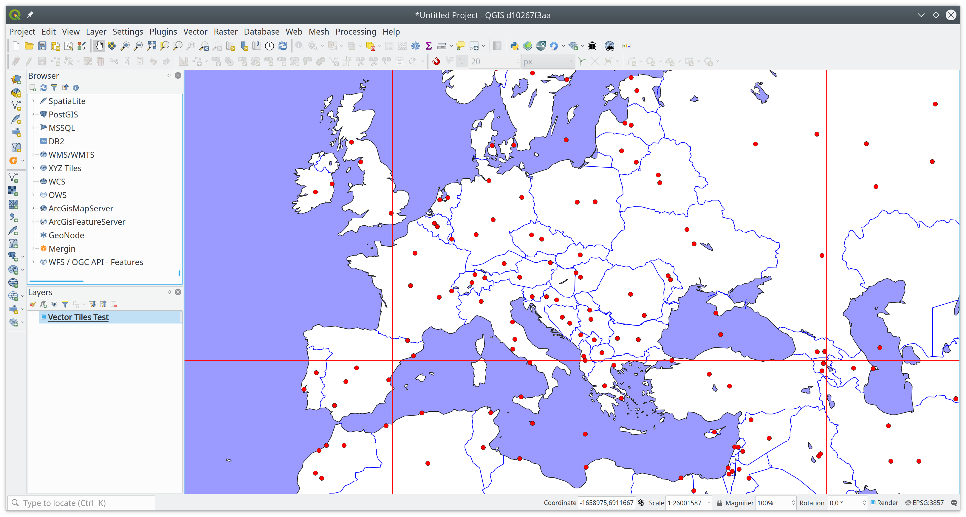 (The red lines are not rendering artifacts, they are drawn intentionally to show tile borders.)
要約(Summary)
So far this only includes changes to the qgis_core library.
Main additions to the public API:
QgsVectorTileLayer - the main map layer class
QgsVectorTileRenderer - base class for renderer class implementations for vector tiles
QgsVectorTileBasicRenderer - default renderer implementation
New private classes (may be added to public API if needed):
QgsVectorTileLoader - handles fetching of tiles from network / mbtiles
QgsVectorTileMVTDecoder - handles decoding of raw tile data to features
QgsVectorTileLayerRenderer - takes care of overall rendering (fetch + decode + draw)
QgsVectorTileUtils - various useful functions
Some new classes that may be shared by vector and raster tiles:
QgsTileXYZ - position of a tile in tile matrix set (zoom level, column, row)
QgsTileRange - rectangular selection in a tile matrix (start/end column and row)
QgsTileMatrix - description of a tile matrix (map extent, zoom level, scale, number of rows/columns)
(also QgsTileMatrixSet to be added later when we support other tile matrix sets than just GoogleCRS84Quad)
Testing
You can load a vector tile layer from Python console, e.g.:
ds = QgsDataSourceUri() ds.setParam("type","xyz")
ds.setParam("url", "https://api.maptiler.com/tiles/v3/{z}/{x}/{y}.pbf?key=YOUR_FREE_API_KEY")
uri = bytes(ds.encodedUri()).decode('utf-8')
vtl = QgsVectorTileLayer(uri, "Vector Tiles Test")
QgsProject.instance().addMapLayer(vtl)
It is also possible to load vector tiles from a local MBTiles file - for "type" use "mbtiles" and for "url" use a local path (e.g. "/home/martin/x.mbtiles").
There is currently no support for labeling.
ありがとうございます
Huge thanks to all funders who have contributed to the crowdfunding and made this possible - https://www.lutraconsulting.co.uk/blog/2020/04/02/vectortiles-donors
この機能は QGIS Community によって資金提供されました
この機能は Lutra Consulting (Martin Dobias) によって開発されました
機能: プロセシング範囲パラメータを新しいAPIに移行し、その他多くの改善を行う
This update ultimately ports the extent parameter to the new c++ api, but along the way it:
Refactors the existing gui widget "QgsExtentGroupBox" to move the guts out to "QgsExtentWidget" (allowing it to be used in places where a group box is inappropriate/looks bad). It also adds a new "condensed" mode for the widget, because the default appearance is very space heavy.
The new parameter widget utilises this common QgsExtentWidget, so that we remove all the duplicate code which was previously used by the old python wrapper
Allows drag and drop of project map layers from the layer tree to a QgsExtentWidget to auto-set the extent to match
Allows QgsExtentWidget to be optionally nullable
エクステントパラメータ値にQgsGeometry値を設定できるようにします。これは、モデルの「事前計算値」モードでエクステントパラメータの使用を支援するために行われます。これで、すべての式ジオメトリ関数を使用してジオメトリを計算でき、このバウンディングボックスが子アルゴリズムのパラメータ値に使用されます。
Refs NRCan Contract#3000707093
この機能は Nyall Dawson によって開発されました
Feature: Interface and API for unified development/debugging tools
Adds interface hooks to allow plugins (and c++) to register "development/debugging" tools
These tools appear in a new Development/Debugging Tools dock, and provide a unified handling and place for these tools in the UI.
The intention here is that specialised development/debugging tools will be moved to this common interface, e.g.
Network logger
First aid style Python local variables inspector
Startup time debugging tools
Layer load and rendering time debugging tools ... ?
Here's an example demo showing a "Python locals" dev tool:
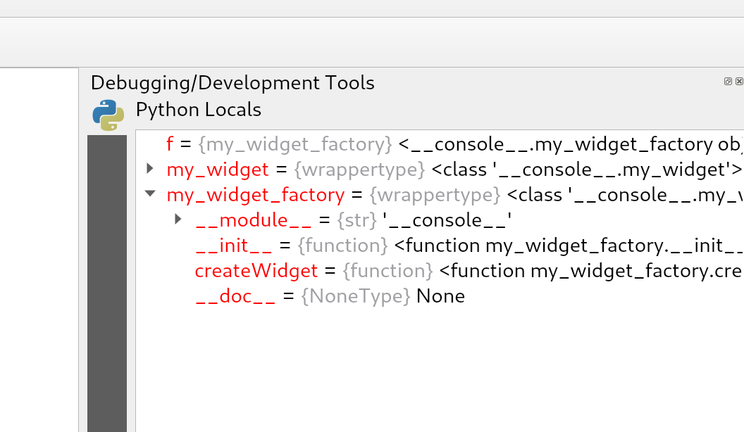
この機能は Nyall Dawson によって開発されました
機能: QgsProcessingParameterMapLayer のデータ型サポート
Allow the definition of accepted layer types for QgsProcessingParameterMapLayer. This is useful when an algorithm can work with different layer types (for example, points and rasters) and avoids duplication of the same algorithm with different inputs.
This is an API improvement and is not visible for the vast majority of users.
この機能は Alexander Bruy によって開発されました
機能: データベーススキーマとテーブル名のためのプロセシングパラメータタイプを追加
Replaces the previous ad-hoc Python postgis widget wrappers with proper first class c++ dedicated parameters for schemas and tables, with wrappers built off the core connections api.
Refs NRCan Contract#3000707093
この機能は Nyall Dawson によって開発されました
注目すべき修正
機能: Alessandro Pasotti によるバグ修正
バグの表題 |
URL issues.qgis.org (報告された場合) |
URL Commit (Github) |
3.10 backport commit (GitHub) |
|---|---|---|---|
Getfeatureinfo does not show relation reference items for QGIS Server |
Turned out to be a feature request |
N/A |
|
OGRプロバイダQgsOgrProvider::changeAttributeValuesは、エラーでtrueを返す |
N/A |
||
GPKG transaction groups are stored with empty second pair of the key |
|||
Symbology using relations does not propagate in QGIS Server |
再現できません |
N/A |
|
「QGIS 3.12.3でPostGISラスタを読み込むとクラッシュする」 |
無関係 |
||
GetFeatureInfoのFid値がapplication/jsonとapplication/vnd.ogc.gmlで異なる |
|||
GPKG (and spatialite) DB-level unique constraints are not supported by OGR (and spatialite) provider |
N/A |
||
no value in the attribute form if value missing in the value map |
N/A |
||
DB Manager does not show anymore query results |
N/A |
||
DB Manager does not show anymore query results |
N/A |
||
GPKG browser drag&drop not working |
未報告 |
||
it is not possible to save a project in the geopackage |
N/A |
||
It is possible to store text into a numeric field, while it shouldn't be, using the Date/Time edit widget |
N/A |
||
Feature creation very slow when using joins |
N/A |
||
QGIS Server: WFS Request does not use SrsName on the geometry |
not critical |
||
Unable to delete a stored geopackage connection from browser |
|||
Constraints: unique constraint not correctly evaluated when 0 |
N/A |
||
PyQgis: OriginJoin fields arte not present into QgsLayerVector QgsFields container for GeoPackage layers |
not reproducible |
N/A |
|
Joined tables cannot be edited even if the "editable join layer" option is checked |
not reproducible/in progress |
N/A |
|
Removal of unused 'allowMethod' from qgisservice/qgisserverapi |
N/A |
||
Omogenize window title |
N/A |
||
Labeling: data-defined alignment grey-out activation issue |
|||
QGIS reports "no layers" in GeoPackage when geopackage directory is write protected |
not critical (UX only) |
||
Joined tables cannot be edited even if the "editable join layer" option is checked |
won't fix |
N/A |
|
Postgis Timestamps from query in DB Manager displayed as `PyQT5.QTCore.QDateTime(2020, 3, 17 |
N/A |
||
Wrong image preview and image preview size in form |
|||
can't change value in vertex editor if "locale" settings use commas as decimal separator |
|||
Identifying a WMS layer with format "feature" crashes QGIS |
|||
Attempting to create a new feature in Spatialite with transaction group and NOT NULL constraint fails |
won't fix |
N/A |
|
Using "Add feature" to create feature and child feature with transaction group causes foreign key error |
not critical |
||
Vectorlayer from spatialite missing features and inconsistent feature count |
TODO |
この機能は QGIS.ORG (through donations and sustaining memberships) によって資金提供されました
この機能は Alessandro Pasotti によって開発されました
機能: Loïc Bartoletti によるバグ修正
バグの表題 |
URL issues.qgis.org (報告された場合) |
URL Commit (Github) |
3.10 backport commit (GitHub) |
|---|---|---|---|
Fix error when vector layer has Z |
|||
Fix rectangle from 3 points |
|||
Allow to search qmlplugindump in different paths |
N/A |
N/A |
|
Fix the absence of words in the advanced configuration widget |
PR #35643#issuecomment-610215386 |
N/A |
|
Fix interpolation on split geometry |
N/A |
この機能は QGIS.ORG (through donations and sustaining memberships) によって資金提供されました
この機能は Loïc Bartoletti によって開発されました
機能: Even Rouault によるバグ修正
バグの表題 |
URL issues.qgis.org (報告された場合) |
URL Commit (Github) |
3.10 backport commit (GitHub) |
|---|---|---|---|
Wrong interpretation of EPSG code from a PRJ file in QGIS-dev (proj v7.1.0) |
N/A: PROJ issue |
||
QGIS crashes when adding file to geopackage -> layer -> field(BLOB) |
|||
Bad error message on WFS connection fail |
|||
QGIS crashes during map re-rendering after CRS switch |
再現できません |
N/A |
|
QGIS crashes when "open directory" is selected from the recent projects contextual menu |
|||
Problem reprojecting rasters in 54019 and 54042 CRSs |
N/A: PROJ issue |
||
WFS Provider WARNING - Cannot create temporary SpatiaLite cache when using flatpak install |
N/A |
||
WFS Transaction operation using GetCapabilities URI |
N/A |
||
二つのPostGISラスタレイヤを表示するとQGIs 3.10.2がクラッシュする |
N/A |
||
QGIS 3.4.10がクラッシュする - Python |
already fixed in master |
||
WMS provider expects SERVICE=WMTS keyword in uppercase to detect WMTS |
|||
WCS DescribeCoverage response origin always empty |
|||
レイヤが0,0にある点を含んでいると範囲を誤る |
QGISのバグではない。GDAL 3.1で修正された |
N/A |
|
Projection not recognised from Mapinfo converstion |
|||
大きなCSVファイルを区切りテキストレイヤとして追加すると、QGISがクラッシュ/フリーズします |
|||
QGIS 3.12 unknown CRS or Select Transformation |
|||
BIGTIFF error is not obvious in processing log |
この機能は QGIS.ORG (through donations and sustaining memberships) によって資金提供されました
この機能は `Even Rouault <http://www.spatialys.com/>`によって開発されました__
機能: Paul Blottiereによるバグ修正
バグの表題 |
URL issues.qgis.org (報告された場合) |
URL Commit (Github) |
3.10 backport commit (GitHub) |
|---|---|---|---|
Fix segfault when adding a layer |
N/A |
||
Fix signal connection |
Unreported issue |
N/A |
|
Update the API to export a legend in JSON |
Unreported binding issue |
N/A |
|
Core dump if vector tile layer (file) becomes unavailable |
再現できません |
N/A |
|
Crash on project open when mapcanvas extents = nan |
再現できません |
N/A |
|
Using some functions in raster calulator crashes QGIS |
N/A |
||
Auxiliary storage not usable in non editable layer |
修正済み。クローズ。 |
N/A |
|
Fix compilation with GCC 10, Qt/PyQt 5.15.0 and SIP 4.19.23 |
この機能は QGIS.ORG (through donations and sustaining memberships) によって資金提供されました
この機能は Paul Blottiere によって開発されました
機能: Julien Cabiecesによるバグ修正
バグの表題 |
URL issues.qgis.org (報告された場合) |
URL Commit (Github) |
3.10 backport commit (GitHub) |
|---|---|---|---|
Reproducible crash using QgsMapCanvas.items() with Oracle layers |
|||
ユーザー式ヘルプパネルで改行が無視される |
|||
「ユーザー式を編集」がユーザー式の名前の変更をできない |
N/A |
||
ラスタシンボロジクラスのラベルを変更できない |
|||
レイヤが利用できないときにクラッシュする |
再現できません |
N/A |
|
Select by expression returns erroneous results with integer field division for shapefiles |
N/A |
||
Using concat(field1, field2) concatenates 0 instead of empty string ('') if any of the fields is NULL |
|||
Stuck at Recent Project window when opening blank file in 3.10.3 |
再現できません |
N/A |
|
QGIS crashes on getting items of mapCanvas scene if features are identified |
|||
sorting on a column that has a value relation is inconsistent |
|||
Missing points (depending on canvas scale) in virtual layer based on sqlite file |
|||
Project is modified as soon as you move cursor on canvas |
|||
Set filter applied to wrong "version" of table when multiple geometry types |
この機能は QGIS.ORG (through donations and sustaining memberships) によって資金提供されました
この機能は Julien Cabieces によって開発されました
機能: Bertrand Rixによるバグ修正
バグの表題 |
URL issues.qgis.org (報告された場合) |
URL Commit (Github) |
3.10 backport commit (GitHub) |
|---|---|---|---|
Vertex tool override global snapping parameters |
N/A |
||
QGIS crashes with QgsGeometry method on empty collection |
N/A |
||
Selective masking: phantom lines on dark background |
N/A |
||
Selective masking: issue with mask opacity |
N/A |
この機能は QGIS.ORG (through donations and sustaining memberships) によって資金提供されました
この機能は Bertrand Rix によって開発されました
機能: Sebastien Peilletによるバグ修正
バグの表題 |
URL issues.qgis.org (報告された場合) |
URL Commit (Github) |
3.10 backport commit (GitHub) |
|---|---|---|---|
[Oracle]Error on save geometries because wrong default values #34482 |
N/A |
||
Invalid query for default value of date column of an oracle layer |
N/A |
||
Fields missing in Visibility by expression for a group in drag/drop form |
N/A |
||
Project custom scales are displayed with scientific notation |
N/A |
||
Oracle : tables are listed once for Polygons and once for MultiPolygons but both show all geometries |
N/A |
||
Can't set min/max values to decimal in raster symbology with QGis Linux versions |
N/A |
この機能は QGIS.ORG (through donations and sustaining memberships) によって資金提供されました
この機能は Sebastien Peillet によって開発されました
機能: Alexander Bruyによるバグ修正
バグの表題 |
URL issues.qgis.org (報告された場合) |
URL Commit (Github) |
3.10 backport commit (GitHub) |
|---|---|---|---|
Copy of truncated variable copies truncated text, not original |
|||
Turning Multi edit mode off does not go back to table view |
|||
GRASS processing: missing parameter name |
|||
Fix redirection of the stdout results to temporary files in GRASS Processing algorithms |
未報告 |
||
GRASSのr.tilesetアルゴリズムを修正 |
未報告 |
||
QgsRasterTerrainAnalysisPlugin: check QgsRelief::processRaster() returned value |
|||
Histogram for graduated style in layer properties disappears when the layer properties window is too small |
|||
Exporting image with atlas option "Save World file" lead to incorrect world file naming (text after dot is missing) |
|||
"Reloading QGIS" from the crash report dialog fails to reopen the project |
|||
Exporting raster style to SLD only works when output file has .sld suffix |
|||
[Style Manager] Missing Favorites category in the "select by group" dialog from "Export symbols" |
not critical |
||
TIN Interpolation - output raster format and size issues |
|||
Layer panel: "Edit Symbol" does nothing if no symbol defined for a rule (in rule-based rendering) |
not critical |
||
Attributes shift in the Service area algorithm results |
未報告 |
N/A |
|
Processing testing framework does not apply rounding to values casted to numbers |
未報告 |
N/A |
この機能は QGIS.ORG (through donations and sustaining memberships) によって資金提供されました
この機能はAlexander Bruyによって開発されました
機能: Nyall Dawsonによるバグ修正
バグの表題 |
URL issues.qgis.org (報告された場合) |
URL Commit (Github) |
3.10 backport commit (GitHub) |
|---|---|---|---|
Fix leak in mesh 3d renderer |
未報告 |
N/A |
|
Fix hang when rendering symbol previews using Meters in Map Unit sizes |
No -- too intrusive |
||
Fix font in CSS code editor |
未報告 |
not critical |
|
Fix rendering of geometry generator expressions which return geometry collection results |
No -- too intrusive |
||
[processing] Correctly expose date time inputs (and a bunch of others) as inputs for in-model expressions |
N/A |
||
Fix all Qt 5.14 deprecation warnings |
未報告 |
No -- too intrusive |
|
[symbology] When rendering a multipart geometry, ensure that geometry generator symbol is only rendered once, instead of once per part |
No -- too intrusive |
||
[layout] Make "show feature count" button apply to all selected indexes |
No -- too intrusive |
||
Fix for container "show as group box" setting is lost when closing layer properties dialog |
N/A |
||
Use even more forceful language to dissuade users from creating custom projections using Proj strings |
No -- string change |
||
Use "markers" terminology consistently in centroid fill widget |
No -- string change |
||
Fixes to numbered list handling in dox/PyQGIS API |
未報告 |
No |
|
Fix cross references in PyQGIS docs |
未報告 |
No |
|
[layouts] Fix attribute table sort order combined with feature filter results in empty tables |
N/A |
||
Fix callout rendering to rotated labels |
N/A |
||
Fix grass output handling in Processing models |
|||
Fix vector datasets incorrectly simplify to rectangles in some CRS views |
No -- too intrusive |
||
Fix list item formatting in PyQGIS docs |
未報告 |
N/A |
|
[processing] Fix manual entry of extent values in widget |
N/A |
||
[decorations] Use a proper ellipsoidal length calculation when calculating the size of the scalebar decoration |
|||
Fix collecting Triangle geometry types after tesselation |
No -- too intrusive |
||
Fix writing triangle geometry type via QgsVectorFileWriter fails |
No -- too intrusive |
||
Fix degradation in Tesselation results |
N/A |
||
Fix layer subset string is ignored when OGR refuses to accept a compiled feature request expression |
|||
[legends] Fix corrupted data defined legend rendering in layout designer |
No -- too intrusive |
||
Avoid some QGIS startup warnings |
未報告 |
N/A |
|
Place 3d tab in vector properties at the correct position |
N/A |
||
Fix 3d tab is not activated when reopening vector layer properties |
N/A |
||
[labeling] Fix incorrect label placement after moving an 'unplaced' label |
未報告 |
||
Don't block creation of new geopackages in vector save as dialog |
未報告 |
N/A |
|
[browser] Refine refreshConnections method to avoid triggering a full refresh of ALL browser content |
No -- too intrusive |
||
[3d] When showing edges, data defined polygon height was not accounted for |
未報告 |
N/A |
|
Fixes for "Show all" labeling mode |
未報告 |
N/A |
|
[3d] Fix reprojection of features shows no features |
N/A |
||
[processing] Add metadata setting for file destination parameters to avoid file overwrite confirmation prompt |
N/A |
||
Avoid incorrectly antialiasing rendering of certain objects (such as map labels) when not wanted |
No -- too intrusive |
||
Ensure that fields required by marker symbol backgrounds for labels are fetched when rendering |
No -- too intrusive |
||
"Fix ""zoom"" and ""flash"" features buttons have no effect when opening filter mode in attribute form" |
N/A |
||
Avoid corrupted project thumbnail images in some circumstances |
未報告 |
N/A |
|
Auto focus search box when opening "add layer to legend" dialog |
not critical |
||
[processing] Set correct output layer type for Point to Layer algorithm |
N/A |
||
"Limit scope of Ctrl+C shortcut for copy features to canvas and for python console to console widget" |
#27035 (many others too) |
No -- too intrusive |
|
Remember layout designer window positions |
not critical |
||
Fix crash when zooming in too far to labels |
|||
[processing] Allow parent layer to be specified for field mapping inputs in models |
No -- too intrusive |
||
Fix placement of message bar 'clear all' menu arrow on hidpi screens |
未報告 |
not critical |
|
Always refresh plugin repositories when manually triggered by user |
|||
[3d] Expose 3d algorithms provider to Python |
No -- too intrusive |
||
[symbology] Don't force rasterized output when exporting point pattern fills |
No -- too intrusive |
||
[layouts] Don't refresh the map canvas multiple times during atlas exports |
not critical |
||
[processing] Fix double-evaluation of warp output parameter |
|||
Fix incorrect warning message when turning off atlas preview |
未報告 |
N/A |
|
Speed up message bar operations when many messages are shown |
No -- too intrusive |
||
Fix oriented minimum bounding box calculation is wrong in some cases |
|||
Ensure symbol opacity is always ignored for selections |
|||
Fix random sort order of symbols in Symbol Export dialog |
|||
Allow clearing heatmap weighting field |
|||
Flag SAGA 'Merge Layers' algorithm as having known issues |
N/A |
||
Workaround odd upstream Qt issue where a painter with a semi-transparent brush with no solid pattern incorrectly applies the brush opacity to the pen when exporting to printer devices |
|||
Improve plugin watchdog message and UX |
未報告 |
No -- too intrusive |
|
"[layouts] Warn when previewing an atlas and a feature with no geometry is encountered, when one or more maps are set to be driven by atlas feature" |
No -- too intrusive |
||
Avoid proj 'object is not a concatenated operation' warnings |
未報告 |
||
"Fix memory layers lose CRS definition if it does not have an authority associated with it" |
|||
Implement spatial index detection for OGR provider |
|||
Fix incorrect dialog title for raster layer properties |
|||
Don't try to identify CRSes created just for ellipsoid definitions |
未報告 |
No -- too intrusive |
この機能は QGIS.ORG (through donations and sustaining memberships) によって資金提供されました
この機能は Nyall Dawson によって開発されました
機能: Denis Rouzaudによるバグ修正
バグの表題 |
URL issues.qgis.org (報告された場合) |
URL Commit (Github) |
3.10 backport commit (GitHub) |
|---|---|---|---|
allow sorting attribute table by field not listed in the table |
N/A |
||
fix layer tree dependencies (showinf symbols and main layer) |
未報告 |
N/A |
|
fix Expression editor: syntax check fails if table is empty |
N/A |
||
fix setting of feature in expression preview widget |
N/A |
||
WFSレイヤの属性テーブルを表示するとフリーズ |
未修正 |
N/A |
|
Lookups in tables with more than 100 entries show wrong value in Relation Reference form parts |
この機能は QGIS.ORG (through donations and sustaining memberships) によって資金提供されました
この機能は Denis Rouzaud によって開発されました
機能: Audun Ellertsenによるバグ修正
バグの表題 |
URL issues.qgis.org (報告された場合) |
URL Commit (Github) |
3.10 backport commit (GitHub) |
|---|---|---|---|
SpatiaLiteでバイナリのフィールドを持ったレイヤのインポートに対応 |
N/A |
||
PostGISでバイナリのフィールドを持ったレイヤのインポートに対応 |
この機能は Kongsberg Digital によって資金提供されました
この機能は Audun Ellertsen によって開発されました