A QGIS 2.14 változásnaplója

Release date: 2016-02-26
Ez a változásnapló a következő QGIS kiadáshoz - 2.14 verzió «Essen» - készült, mely város volt a házigazdája a 2012. és 2014. októberi fejlesztői találkozónak.
Hosszútávú kiadás
Ez egy különleges kiadás mivel «LTR»-nek (hosszú távú kiadás) jelölték. Az LTR kiadásokba egy évig visszavezetik a hibajavításokat és befagyasztják a funkció bővítést (nem adnak hozzá új funkciót, csak hibajavítások és triviális frissítések történnek). Vegye figyelembe, hogy tárgyalunk a LTR kiadások idejének két évre történő kiterjesztéséről, de technikai okokból a QGIS 3.2 kiadásig ez nem történik meg.
Az LTR kiadások célja, hogy egy stabil, kevésbé gyakran változó platformot biztosítson azoknak a vállalatoknak és szervezeteknek, melyek évente egynél többször nem akarnak foglalkozni a felhasználói ismeretek, az oktató anyagok, stb. frissítésével. Az LTR sikere nagyban öntől függ, a kedves felhasználóinktól - szükségünk van a támogatására a hibajavítások finanszírozásában és bizonyosodjon meg róla, hogy a támogatás nyújtó szerződésében vállalja a hibajavítások átvezetését az LTR ágon és a fejlesztési ágon is.
Ha egy LTR fontos önnek, kérjük fontolja meg a QGIS projekt közvetlen támogatását, ösztönözze a kereskedelmi szolgáltatóját, hogy az LTR-t használja a vállalati megoldás alapjául, így mindenkinek előnyös lehet a stabil platform, melyet folyamatosan javítanak és finomítanak. Ne feledje, hogy a négy hónaponkénti kiadások töretlenül folytatódnak azoknak a felhasználóknak és szervezeteknek, akik élen akarnak járni.
Újdonságok a QGIS 2.14 «Essen»-ben
Ha a QGIS 2.8-ról (a korábbi LTR verziónk) frissít nagyon sok új funkciót talál majd ebben a kiadásban. Arra bátorítjuk, hogy olvassa el a közbenső nem LTR 2.10 és 2.12 kiadások változásnaplóját, mivel ez a QGIS 2.14 tartalmazza azokban a kiadásokban publikált funkciókat is. Vegye figyelembe, hogy a 2.14 először az általános csomag könyvtárba kerül és váltja fel a 2.8-at az LTR csomag tárházban. Ez a 2.16 kiadása után történik meg.
Amikor egy új funkciót adnak a szoftverhez azzal az új hibák lehetőségét is bevezetik - ha bármilyen problémával találkozik ebben a kiadásban, kérjük küldjön egy jelzést a QGIS hibakövetőben.
Köszönet
Köszönetet szeretnénk mondani a fejlesztőknek, a dokumentáció készítőknek, a tesztelőknek és sokaknak akik önként felajánlták az idejüket és erőfeszítésüket (vagy adományt adtak, hogy mások tegyék). A QGIS közösség nevében reméljük élvezni fogja ezt a kiadást! Ha idővel, pénzzel vagy más módon támogatást akar nyújtani, hogy a QGIS-t még fantasztikusabbá tegyük, kérjük nézze meg a qgis.org oldalt és segítsen!
QGIS is supported by donors and sponsors. A current list of donors who have made financial contributions large and small to the project can be seen on our donors list. If you would like to become an official project sponsor, please visit our sponsorship page for details. Sponsoring QGIS helps us to fund our six-monthly developer meetings, maintain project infrastructure and fund bug fixing efforts. A complete list of current sponsors is provided below - our very great thank you to all of our sponsors!
A QGIS szabad szoftver és semmi sem kötelezi arra, hogy fizessen használatáért. Valójában a QGIS használatára bátorítjuk az embereket, legyenek bárhol a világon, pénzügyi és társadalmi helyzettől függetlenül. Hiszünk benne, hogy térbeli döntéstámogatási eszközök biztosítása jobb társadalmakat eredményez az emberiség egészének hasznára. Ha lehetősége van a QGIS támogatására, |itt adományozhat|
QGIS szponzorok
|silver| |opw| Office of Public Works, Ireland, Írország (12.2014-12.2016) |
|
|
|
|


Asociación Geoinnova, Spanyolország (2016.03-2017.03) |
Gis3W, Olaszország (2014.01-2017.01) |
GKG Kassel,(Dr.-Ing. Claas Leiner), Németország (2014.03-2017.03) |
CawdorForestry Resource Management, Skócia (2016-02-2017.02) |
ChameleonJohn, USA (2016.02-2017.02) |
2D3D.GIS, Franciaország (2015.12-2016.12) |
Dr. Kerth + Lampe Geo-Infometric GmbH, Németország (2015.12-2016.12) |
MappingGIS, Spanyolország (2015.11-2016.11) |
HostingFacts.com, Észtország (2015.12-2016.12) |
Urbsol, Ausztrália (2014.11-2016.11) |
Lutra Consulting, UK (2015.10-2016.10) |
WhereGroup GmbH & Co. KG, Németország (2015-08-2016.08) |
Nicholas Pearson Associates, UK (2015.07-2016.07) |
QGIS Polska, Lengyelország (2015.07-2016.07) |
www.terrelogiche.com, Olaszország (2015.06-2016.06) |
www.geosynergy.com.au, Ausztrália (2012.05-2013.05+2015.06-2016.06) |
Gaia3D, Inc., Dél-Korea (2015.05-2016.05) |
Royal Borough of Windsor and Maidenhead, UK (2015.04-2016.04) |
Chartwell Consultants Ltd., Kanada (2015.03-2016.03) |
Trage Wegen vzw, Belgium (2015.03-2016.03) |
GFI - Gesellschaft für Informationstechnologie mbH, Németország (2015.03-2016.03) |
GIS-Support, Lengyelország (2015.02-2016.02) |
ADLARES GmbH, Németország (2015-01-2016.01) |
www.molitec.it, Olaszország (2014.01-2016.01) |
www.argusoft.de, Németország (2012.06-2013.06 + 2013.12-2015.12) |
Customer Analytics, USA (2014.12-2015.12) |


Általános
Funkció: az strpos függvény módosult viselkedése
The strpos function behaviour has been altered, so that no match now results in a „0” value and a non-zero value means a match at the specified character position. In older QGIS versions, a „-1” value would mean no-match and other return values represented the character position - 1.
A korábbi QGIS verziókból származó projekt fájlokat aktualizálni kell, hogy ezt a változást tükrözzék.
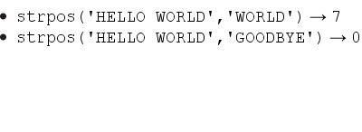
Ezt a funkciót Jürgen Fischer fejlesztette
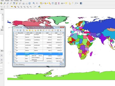
Funkció: Nagyítás az elemre jobb gomb kattintással az attribútum táblában
Bármelyik elemre nagyíthat a az attribútum táblából (anélkül, hogy előbb szelektálná), jobb gomb kattintás után válassza a nagyítás az elemre menüpontot.
Funkció: Sebesség és memória javítások
Szelektált elemek halmazának mentése egy nagy méretű rétegből most sokkal gyorsabb
A szelektált elemek aktualizálása a mező kalkulátor segítségével most gyorsabb
Gyorsabb nagyítás a szelektáltakra nagy rétegeken
Sokkal gyorsabb
get_featurefüggvény (különösen amikor a hivatkozott réteg indexelt oszlopára hivatkozik)SelectByAttributeandExtractByAttributeprocessing algorithms are orders of magnitude faster, and can take advantage of database indices created on an attributePointsInPolygonfeldolgozás algoritmus több nagyságrenddel gyorsabbFiltering the categories in a categorised renderer (eg, only showing some categories and unchecking others) is much faster, as now only the matching features are fetched from the data provider
Significant reduction in the memory required for opening large vector layers
Funkció: Több kifejezés változó
Rajzolás közben új változók használhatók:
@geometry_part_count: Az aktuálisan rajzolt geometria részeinek száma (többrészű elemek esetén érdekes)@geometry_part_num: 1-től kezdődő indexe az aktuálisan rajzolt geometria résznek
Ezek hasznosak, hogy többrészű elemek különböző részeire eltérő stílust alkalmazzuk:
@map_extent_width: Az aktuális rajzolt térkép szélessége térképi egységekben@map_extent_height: Az aktuális rajzolt térkép magassága térképi egységekben@map_extent_center: Az aktuális rajzolt térkép középpontja térképi egységekben
Az operációs rendszer környezettel kapcsolatos változókat is adtunk a rendszerhez:
@qgis_os_name: pl. «Linux», «Windows» vagy «OSX»@qgis_platform: pl. «Desktop» vagy «Server»@user_account_name: aktuális felhasználó operációs rendszerbeli neve@user_full_name: aktuális felhasználó operációs rendszerbeli neve (ha elérhető)
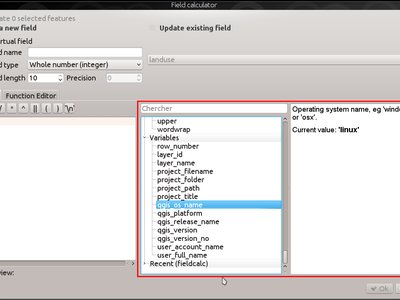
Ezt a funkciót Andreas Neumann támogatta (az operációs rendszerrel és felhasználóval kapcsolatos változók)
Ezt a funkciót Nyall Dawson és Matthias Kuhn fejlesztette
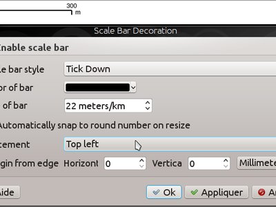
Funkció: Jobb felügyelet a térkép elemek elhelyezésében
QGIS 2.14 has gained finer control over the placement of north arrows, scale bars and copyright notices on the main map canvas. You can now precisely set the position of these elements using a variety of units (including millimeters, pixels and percent).
Funkció: Fizetett hibajavítás program
Prior to each release, we hold a paid bugfixing programme where we fund developers to clean up as many bugs as possible. We have decided to start including a report back on the paid bugfixing programme as part of our changelog report. Note that this list is not exhaustive.
Sandro Santilli: Postgis Connection freeze if you press „Set filter” during loading of data
Sandro Santilli: db_manager is unable to load rasters from connections with no dbname specified
Sandro Santilli: Plugin layers do not work correctly with rotation
Sandro Santilli: Crash in QgsGeomColumnTypeThread stopping connection scan #14140 #13806
Sandro Santilli: Crash after bulk change of attribute value in shapefile
Sandro Santilli: KMZ causes QGIS application crash (Mac)
Sandro Santilli: QGIS 2.8.1 crash opening FileGDB (openGDB-Driver)
Sandro Santilli: QGIS crashes when removing vertex of a multipart geometry
Sandro Santilli: test -V -R qgis_analyzertest segfaults
Sandro Santilli: output/bin/qgis_diagramtest segfaults
Sandro Santilli: Overflow on primary key with negative values; crashes QGIS when editing #13958 #14262
Sandro Santilli: PyQgsPostgresProvider test hangs in absence of test database
Sandro Santilli: TestVectorLayerJoinBuffer hangs if database is not available
Nyall Dawson: BLOCKER: Crash when opening layer properties dialog for geometryless vector layer
Nyall Dawson: Broken server side filtering for OGR, Oracle and Spatialite layers
Nyall Dawson: BLOCKER: Bad polygon digitizing in master
Nyall Dawson: BLOCKER: Heatmap with expression triggers segfault
Nyall Dawson: BLOCKER: unchecking one sub-layer of a categorized symbology leads to no features being drawn
Nyall Dawson: HIGH: A Multiband image(e.g. landsat5,7,8) cannot be displayed in windows8
Nyall Dawson: BLOCKER: CurvePolygons not drawn
Nyall Dawson: BLOCKER: „Merge Attributes” tool doesn’t change values when they are typed
Nyall Dawson: HIGH: Filter legend by content is broken when renderer contains duplicate symbols
Nyall Dawson: Fix issues with conversion of renderers to rule based renderer resulting in broken renderer
Nyall Dawson: Fix categorised renderer does not store changes to the source symbol
Nyall Dawson: HIGH: Avoid crash with raster calculator and huge raster inputs
Nyall Dawson: HIGH: @value variable of simple symbol fill color wrongly gets modified in data-defined expression
Nyall Dawson: HIGH: Editing Composer legend while filtered does not work
Nyall Dawson: NORMAL: Deleting nodes - inconsistent behaviour
Nyall Dawson: Fix handling of time value in attributes
Nyall Dawson: párbeszédablakok fül sorrend javítások
Nyall Dawson: BLOCKER: crash when adding multiple files from browser panel
Nyall Dawson: HIGH: Merge selected features tool corrupts data when columns are defined as „hidden”
Nyall Dawson: Correctly handle LongLong fields in merge attribute dialog
Nyall Dawson: Fix misleading display of calculation details in measure tool dialog (was misleading and inaccurate for many CRS/unit combinations)
Nyall Dawson: NORMAL: max value for option „increase size of small diagrams” not sufficient
Nyall Dawson: BLOCKER: Area not calculated correctly with OTF on
Nyall Dawson: NORMAL: Incoherent lat/lon coordinates in a projected coordinate system project
Nyall Dawson: NORMAL: make the field calculator compute areas and lengths in units other than map units #12939 #2402 #4857
Nyall Dawson: NORMAL: different built-in tools calculate inconsistent polygon areas
Nyall Dawson: NORMAL: In virtual fields $area function computes always values using „None/planimetric” ellipsoid
Martin Dobias: raster layer drawn as garbage
Martin Dobias: HIGH: Multi-threaded rendering and OTF reprojection issues #11441 #11746
Martin Dobias: BLOCKER: Regression in „save as” dialog for shapefiles
Martin Dobias: Attribútum tábla lassú betöltése hibakeresés módban
Martin Dobias: BLOCKER: Crash when changing renderer type
Martin Dobias: HIGH: Custom python renderer issues #1
Martin Dobias: HIGH: Custom python renderer issues #2
Martin Dobias: 2.5d megjelenítés javítása
Martin Dobias: HIGH: Long freeze when initializing snapping
Martin Dobias: NORMAL: Loading of data-defined from xml
Martin Dobias: DB kezelő javítás, hogy SpatiaLite 4.2 előtti verzióval dolgozzon
Martin Dobias: NORMAL: Crash while rendering in debug mode
Martin Dobias: BLOCKER: Fix selection / identification in spatialite views #14232 #14233
Martin Dobias: BLOCKER: Fix drag&drop of spatialite tables
Jürgen Fischer:Zoom to layer works incorrectly while layer editing
Jürgen Fischer:Help viewer process running in the background with no help viewer (or even QGIS) open
Jürgen Fischer:Spatialindex include path missing in some components
Jürgen Fischer:compile fails attempting to generate qgsversion.h
Jürgen Fischer:Edit widget configuration is stored twice
Jürgen Fischer:Extra space in „IS NOT” operator makes the expression return wrong selection
Jürgen Fischer:QGIS greadily allocates memory and crashes when editing moderately large shapefiles with the node tool
Jürgen Fischer:French reprojection use ntf_r93.gsb (IGNF:LAMBE etc ..)
Jürgen Fischer:Digitizing: „Reuse last entered attribute values” should not overwrite primary key column
Jürgen Fischer:Issues in Case expression description
Jürgen Fischer:shapefile vector writer: datetime field saved as date resulting in data loss of time
Jürgen Fischer:Add help for some variable functions
Jürgen Fischer:Virtual layers not working in Processing
Jürgen Fischer:layer definition file load error
Jürgen Fischer:QgsGeometry::fromWkb fails if WKB is different endian representation
Jürgen Fischer:Debian build failure.
Jürgen Fischer:PyQgsPostgresProvider test hangs in absence of test database
Jürgen Fischer:wkb access out of bounds
Jürgen Fischer:QGIS under Windows netCDF import reverses Y axis, Linux doesn’t OSGeo4W #483
Jürgen Fischer:OSGEO4W: Running offline install crashes installer
Jürgen Fischer:OSGEO4W: Dependencies are not tracking on Windows Server 2003 x64
Jürgen Fischer:OSGEO4W: installation from local package don’t check the dependencies
Jürgen Fischer:OSGEO4W: Setup starts downloading and installing packages before showing you a list to choose from
Jürgen Fischer:OSGEO4W: Using -a for Advanced selects two options (command line install)
Jürgen Fischer:OSGEO4W: Infinite license download during quite installation of szip
Jürgen Fischer:Oracle provider deadlock
Jürgen Fischer: saga útvonal beállítás javítása
Funkció: A mező kalkulátos használható az elem geometria aktualizálsára
The field calculator can now be used to update feature geometries using the result of a geometric expression. This is a handy shortcut to do operations such as apply a buffer to a group of selected features, and together with all the newly added geometry functions in 2.14 makes for a very handy way to manipulate your geometries!
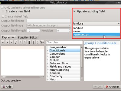
Ezt a funkciót fejlesztette:** Nyall Dawson
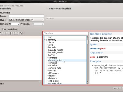
Funkció: Új kifejezés függvények a 2.14-ben
Lots of new expression functions have been added for version 2.14:
relate: performs a DE-9IM geometry relation by either returning the DE-9IM representation of the relationship between two geometries, or by testing whether the DE-9IM relationship matches a specified pattern.the
make_pointfunction now accepts optional z and m values, and a newmake_point_mfunction has been added for creation of PointM geometries.mandzfunctions for retrieving the m and z values from a point geometrynew
make_lineandmake_polygonfunctions, for creation of line and polygon geometries from a set of pointsreverse, for reversing linestringsevalfunction, which can evaluate a string as though it is an expression of its owntranslatefunction, for translating geometries by an x/y offsetdarkerandlighterfunctions, which take a color argument and make it darker or lighter by a specified amountradiansanddegrees: for converting angles between radians and degreespoint_on_surface: returns a point on the surface of a geometryexterior_ring: returns the exterior ring for a polygon geometryis_closed: returns true if a linestring is closednew geometry accessor functions:
geometry_n(returns a specific geometry from within a collection),interior_ring_n(returns an interior ring from within a polygon)num_geometries: returns number of geometries inside a collectionnum_rings: returns number of rings in a polygon geometry objectnum_interior_rings: a belső gyűrűk számát adja vissza a felületbennodes_to_points, for converting every node in a geometry to a multipoint geometrysegments_to_lines, for converting every segment in a geometry to a multiline geometryclosest_point: returns closest point in a geometry to a second geometryshortest_line: returns the shortest possible line joining two geometries
nodes_to_points and segments_to_lines are intended for use with
geometry generator symbology, eg to allow use of m and z values for
nodes/lines with data defined symbology.
További javítások:
geometries and features can now be used in conditional functions. For instance, this allows expressions like
case when $geometry then ... else ...andcase when get_feature(...) then ... else ...
Elemző eszközök
Feature: More statistics available in merge attributes tool
When using either the merge attribute values or merge features tool, there are additional summary statistics available which can be used to set the resultant attribute values. These include Q1, Q3, inter-quartile ranges, majority and minority values, and number of unique values, amongst others.
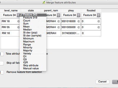
Ezt a funkciót fejlesztette:** Nyall Dawson
Feature: z/m values are shown when using the identify tool
The identify tool is now able to show any z or m value present in the identified features. If the feature is a line or polygon, the tool will show the vertex number and x/y/z/m for the nearest vertex to the identified point. The identify tool now also shows the number of parts and part number for collections.
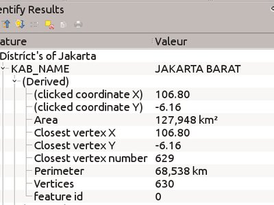
Ezt a funkciót fejlesztette:** Nyall Dawson
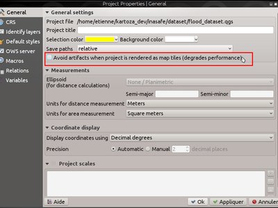
Feature: Unified handling of distance and area units and coordinate formats
In QGIS 2.14 the handling of various options regarding distance units, area units and coordinate display have been unified, simplified, and moved to Project Properties. This change brings numerous benefits, including:
The coordinate format specified in Project Properties is consistently used whenever a coordinate is displayed to the user, including the identify tool results and the status bar display.
The setting for distance and area units in Project Properties is respected for all distance and area calculations, including the measure tool, identify results, and use of the
$area,$lengthand$perimeterfunctions.Additional area units have been added, including square yards, acres, hectares and more.
Additional angular units have been added to the angle measurement tool, including rotations, minutes of arc and seconds of arc.
It’s now possible to show the coordinates in latitude and longitude in the status bar even when using a projected CRS.
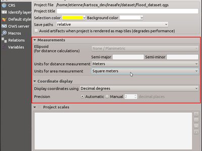
This feature was funded by QGIS sponsored bug fixing program
Ezt a funkciót fejlesztette:** Nyall Dawson
Böngésző
Funkció: Böngésző javítások
The QGIS Browser is a filesystem, OGC Web Services and Database Connection panel that lets you easily drag and drop any layer from the aforementioned sources into your map canvas (or into the DB Manager window). Two useful new improvements were added for this release:
Paths can be selectively hidden from the browser panel - this is useful to declutter your sources list and focus only on relevant directories.
Load projects directly from the browser - now you can drag and drop a whole project into the QGIS map canvas and it will be loaded.
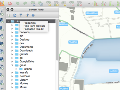
Ezt a funkciót Nathan Woodrow fejlesztette
Adatszolgáltatók
Feature: Cache WMS capabililies
QGIS will now cache WMS GetCapabilities requests so that on
subsequent use response times will be quicker when using that service.
By default the cache period is 24 hours, but you can adjust this in the
Network tab of the QGIS Settings dialog.
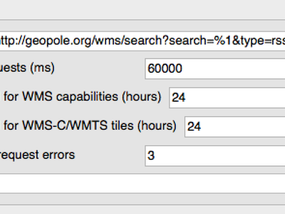
Ezt a funkciót Jürgen Fischer fejlesztette
Funkció: az íves geometria támogatás kibővítve
The delimited text provider now supports curved WKT strings, and the memory provider (eg „temporary scratch” layers) has gained full support for curved geometries. Additionally, if QGIS has been built using GDAL versions 2.0 and up then QGIS will fully support curved geometries in supported file types (eg GML files).
Ezt a funkciót fejlesztette:** Nyall Dawson
Funkció: Az idő valamint az idő és dátum mezők jobb kezelése
A QGIS 2.14 verzióban javították az idő valamint az idő és dátum típusú mezők kezelését, többek között:
PostgreSQL időbélyeg mezőket megfelelően kezeljük
The expression engine now has full support for time fields
The expression builder now shows preview calculation results for date, time, date time and interval calculations
Time fields are fully supported by vector file layers (depending on file format), PostgreSQL, MS SQL Server and temporary scratch layers
Saving layers to vector files will preserve time fields if supported by vector layer format (eg MapInfo .tab files)
This feature was developed by Jürgen Fischer, Nyall Dawson
Funkció: Z/M értékek támogatása a tagolt szöveg szolgáltatóban
The delimited text provider has gained support for WKT strings
containing Z and M coordinates. For example you can express a point with
z and measure elements like this : POINT ZM (1 1 5 60).
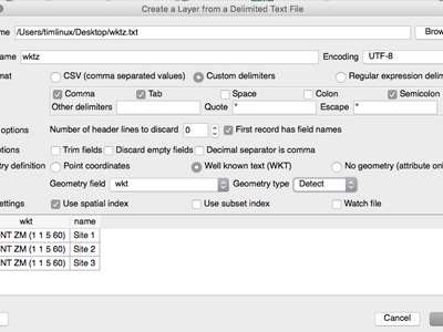
Ezt a funkciót fejlesztette:** Nyall Dawson
Funkció: Tranzakció csoportok a postgres szerkesztéshez
Új beállítást vezettünk be a tranzakció alapú szerkesztés bekapcsolásához.
Amikor ez az opció be van kapcsolva
Ugyanabból az adatbázisból származó rétegeket egy tranzakció csoportba tesszük
Amikor a csoport első rétegét szerkeszthetővé tesszük, az összes többi automatikusan szerkeszthetővé válik
Amikor egy réteget szerkeszt a változásokat azonnal elküldjük az adatbázisba, ezzel lehetővé téve, hogy a triggereket és kényszereket azonnal alkalmazzuk
When one layer in a transaction group is committed, all layers are committed (database transaction)
When one layer in a transaction group is rolled back, all layers are rolled back (database transaction)
Ez még egy kísérleti funkció. Ha bármilyen problémát tapasztal ~jelentse azt <https://www.qgis.org/en/site/getinvolved/development/bugreporting.html>`__.
Ezt jelenleg csak a postgres adatbázisok esetén valósítottuk meg.
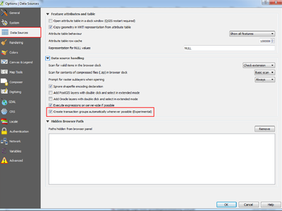
A funkciót támogatta: SIGE
Ezt a funkciót fejlesztette: Matthias Kuhn OpenGIS.ch, a Sourcepole munkájára alapozottan
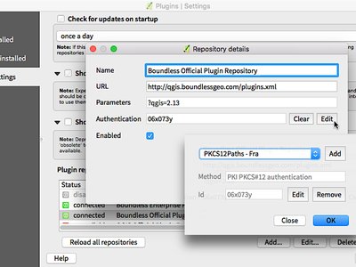
Feature: Postgres provider PKI authentication
The ability to use the QGIS Authentication Manager introduced in 2.12 has been extended to the PostGIS provider. This allows connecting to Postgres using basic or PKI authentication, with the credentials stored in the QGIS configuration. The new Postgres provider authentication can also be used in the DB manager.
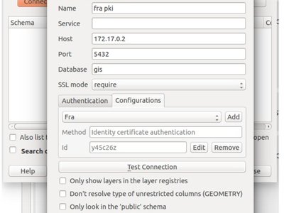
Ezt a funkciót támogatta: Boundless Spatial
Ezt a funkciót Luigi Pirelli fejlesztette
Funkció: Virtuális rétegek
Dynamic SQL queries can now be used on any kind of vector layers that QGIS is able to load, even if it the layer format itself has no support for SQL queries!
A new kind of vector layer called „virtual layer” is now available for that purpose. These allow you to create a virtual layer by defining a query (including support for aggregates and joins) from other layers in your project. The resultant layer will be a live, dynamic view of the query result, so any changes to the source layers will be automatically and immediately reflected in the virtual layer!
The supported SQL dialect is SQLite with Spatialite functions. QGIS expression functions can also be used in queries. Any kind of vector layers can be accessed in the query, including multiple layers from different data providers to make joins.
Support for virtual layers has also been added to DB Manager as well as to the Processing toolbox where a new «Execute SQL» tool is available.
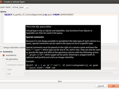
Ezt a funkciót támogatta: MEDDE (French Ministry of Sustainable Development)
Ezt a funkciót fejlesztette: Hugo Mercier / Oslandia <http://oslandia.com>`__
Funkció: Több fájl kiterjesztés a GDAL és OGR szolgáltató fájl kiválasztóban
For vector and raster files, QGIS relies on the GDAL/OGR library. It means that nearly any file format that can be opened by GDAL or OGR can be directly opened in QGIS. Until now, some file extensions were not added in the GDAL or OGR file selector, resulting in users believing that QGIS could not open or handle those file formats. To minimise this problem, some new extensions have been added to GDAL and OGR file selector filters:
Vektor fájlokhoz:
.thf EDIGEO Francia kataszter formátum
.ods OpenDocument számolótábla LibreOffice formátum
.xls Microsoft Excel formátum
.xlsx Microsoft Excel OpenXML formátum
.xml for NAS - ALKIS formátum
.map WAsP formátum
.pix PCIDSK formátum
.gtm és .gtz GPSTrackMaker formátum
.vfk VFK formátum
.osm és .pbf for OpenStreetMap formátum
.sua SUA formátum
.txt OpenAir formátum
.xml Planetary Data Systems TABLE formátum
.htf Hydrographic Transfer Formátum
.svg SVG formátum
.gen ARCGEN
.sxf Storage and eXchange Formátum
.pdf Geospatial PDF vektor formátum
.sgy és .segy for SEG-Y formátum
.seg, .seg1, .sp1, .uko, .ukooa SEGUKOOA formátum
.ovf VRT vektor fájl formátum
.kmz tömörített KML (KMZ) formátum
.db3, .s3db, .sqlite3, .db3, .s3db, .sqlite3 SQLite/Spatialite formátum
.sl3 SQLite Spatial (FDO) formátum
CouchDB Spatial (via URL)
Raszter fájlokhoz:
.ovr vrt raszter fájl formátum
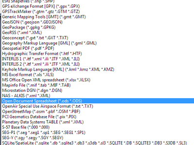
Ezt a funkciót fejlesztette: Médéric Ribreux
Feature: Use ST_RemoveRepeatedPoints for server-side simplification with PostGIS 2.2 (or newer) layers
When using a PostGIS 2.2 instance, QGIS now uses the ST_RemoveRepeatedPoints function instead of the ST_SnapToGrid function to process server-side simplification, as described by Paul Ramsey.
This method will decrease the number of vertices of the geometries that QGIS needs to download from the server, which will increase rendering speed and save bandwith between QGIS and the PostgreSQL server.
This feature was developed by Michaël Douchin @kimaidou
Adatkezelés
Funkció: SPIT modul eltávolítása
The „SPIT” plugin is no longer bundled with QGIS, as the plugin was unmaintained and has been surpassed by DB Manager and the processing database import algorithms.
Ezt a funkciót Nathan Woodrow fejlesztette
Feature: DXF export: option to use title instead of name as DXF layer name in application and server
A funkciót támogatta: City of Uster
Ezt a funkciót Jürgen Fischer fejlesztette
Funkció: geometria típus felülírható a mentés másként párbeszédablakban
This makes it possible to do things like save a geometryless table WITH a geometry type, so that geometries can then be manually added to rows. Previously this was only possible to do in QGIS by resorting to dummy joins or other workarounds.
Additionally, options have been added for forcing the output file to be multi type, or include a z-dimension.

Ezt a funkciót fejlesztette:** Nyall Dawson
Feature: Vector joins are now saved within QLR layer-definition-files
Funkció: Külső erőforrás vezérlő
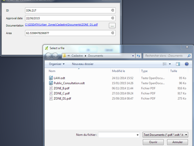
A new form widget is now available. It is named „External resource” and it allows a more complete handling of attributes assigned to file paths storing. Here is a complete summary of the widget features:
You can set an extension filter to force the storing of fixed file formats. If a filter is set, the file selector will only show file names that are relevant to the filter (it is still possible to select any file by using «*» character in the search field). Filter syntax is the same than Qt widget QFileDialog::getOpenFileName.
You can set a default path. Each time a user triggers the widget, a file selector will open at the default path (if set). If no default path has been set, the file selector will use the last path selected from an „External resource” widget. If the widget has never been used, the file selector defaults to opening on the project path.
You can define and set relative path storing. Relative path storing will allow you to save only the part of the path which is after the default path (if default path is set) or the current project path. This is particularly useful when you want to save long paths into limited size attributes (like text attributes for Shapefiles which are limited to 254 characters), or for creating self-contained project and data file archives for distribution.
Another new feature to make the widget easier to use is that file paths can now be displayed as hyperlinks. Clicking the hyperlink will directly open the linked file from QGIS. You can configure this option to display the full path of the file or only its file name. The file will be opened using the default handler for that file format from your operating system.
You can also use a URL instead of a file path. The widget will interpret it as a URL and you will be able to open the linked web page directly in your default web browser.
You can choose to store directory paths instead of file paths.
There is an integrated document viewer in this widget. You can use it to display pictures or webpages directly into QGIS. The file chooser for the integrated viewer will benefit from all the above mentioned options.
For more information on configuration options, you can use the tool tips of the configuration dialog box.
The main aim of this new widget is to fix and improve the two existing «File name» and «Photo» widgets, and replace them with a single unified widget. For the moment, you can still use the old widgets but they will be deprecated and removed for QGIS 3.0. We recommend to switch your projects to use the new «External Resource» widget now.
Ezt a funkciót fejlesztette:
Matthias Kuhn OPENGIS.ch
Feature: N:M relation editing
This adds the possibility to manage data on a normalised relational database in N:M (many to many) relations. On the relation editor in a form, the tools to add, delete, link and unlink also work on the linking table if a relation is visualized as a N:M relation.
Configuration is done through the fields tab where on the relation a second relation can be chosen (if there is a suitable relation in terms of a second relation on the linking table).
Korlátozások:
A QGIS nem egy adatabázis kezelő rendszer
It is based on assumptions about the underlying database system. In particular:
it expects an
ON DELETE CASCADEor similar measure on the second relationit does not take care of setting the primary key when adding features. Either users need to be instructed to set them manually or - if it’s a database derived value - the layers need to be in transaction mode
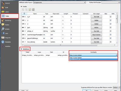
This feature was funded by République et canton de Neuchâtel, Ville de Pully, Ville de Vevey
Ezt a funkciót fejlesztette: Matthias Kuhn
Digitalizálás
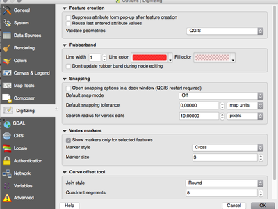
Funkció: Konfigurálható gumiszalag szín
Most már be lehet állítani a gumiszalag szélességét és színét a digitalizálásra.
Feature: Trace digitising tool
The new trace digitising tool is an advanced digitising tool that allows you to digitise features in one layer by tracing features in another layer.
The trace tool:
uses Dijkstra’s shortest path algorithm to find traceable routes
can trace routes over multiple distinct features
can be used with Advanced Digitising tools (e.g. reshaping)
can be enabled and disabled by pressing T on your keyboard while digitising
is fast and easy to use
You can read more about this feature here and with this tutorial.
This feature was funded by: The Royal Borough of Windsor and Maidenhead, Neath Port Talbot County Borough Council, Ujaval Gandhi, Surrey Heath Borough Council, Matias Arnold, Northumberland National Park Authority, Buccleuch Estates Limited, Countryscape

This feature was developed by Lutra Consulting
Címkézés
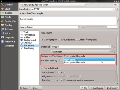
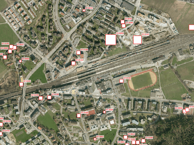
Feature: „Cartographic” placement mode for point labels
In this placement mode, point label candidates are generated following ideal cartographic placement rules, eg label placements are prioritised in the order:
jobb felső
bal felső
jobb alsó
bal alsó
jobb közép
bal közép
top, slightly right
bottom, slightly left
(respecting the guidelines from Krygier and Wood (2011) and other cartographic master works)
Placement priority can also be set for an individual feature using a data defined list of prioritised positions. This also allows for only certain placements to be used, so eg for coastal features you could prevent labels being placed over the land.
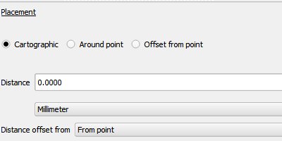
Ezt a funkciót Andreas Neumann támogatta
Ezt a funkciót fejlesztette:** Nyall Dawson
Feature: Applying label distance from symbol bounds
When this setting is active, the label distance applies from the bounds of the rendered symbol for a point instead of the point itself. It is especially useful when the symbol size is not fixed, eg if it is set by a data defined size or when using different symbols in a categorised renderer.
Note that this setting is only available with the new Cartographic point label placement mode.
Ezt a funkciót Andreas Neumann támogatta
Ezt a funkciót fejlesztette:** Nyall Dawson
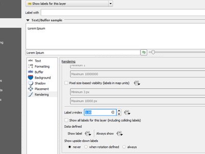
Funkció: Felügyelet a címke rajzolási sorrend felett
A new control for setting a label’s „z-index” has been added to the labeling properties dialog. This control (which also accepts data-defined overrides for individual features) determines the order in which labels are rendered. Label layers with a higher z-index are rendered on top of labels from a layer with a lower z-index.
Additionally, the logic has been tweaked so that if 2 labels have matching z-indexes, then:
if they are from the same layer, a smaller label will always be drawn above a larger label
if they are from different layers, the labels will be drawn in the same order as the layers themselves (ie respecting the order set in the legend)
Diagrams can also have their z-index set (but not data defined) so that the order of labels and diagrams can be controlled.
Note that this does NOT allow labels to be drawn below the features from other layers, it just controls the order in which labels are drawn on top of your map.
Ezt a funkciót fejlesztette:** Nyall Dawson
Feature: Actual rendered symbol is now considered as an obstacle for point feature labels
Previously, only the point feature itself was treated as an obstacle for label candidates. If a large or offset symbol was used for the point, then labels were allowed to overlap this symbol without incurring the obstacle cost.
Now, the actual size and offset of the rendered symbol are considered when detecting whether a label collides with a point feature. The result is that QGIS now avoids drawing labels over point symbols in more circumstances.
A funkciót támogatta City of Uster
Ezt a funkciót fejlesztette:** Nyall Dawson
Réteg jelmagyarázat
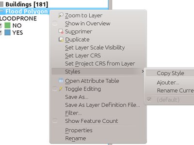
Feature: Paste a style to multiple selected layers or to all layers in a legend group
This feature adds the possibility to paste the style of one layer to a layer group or selected layers.
Ezt a funkciót fejlesztette Salvatore Larosa
Funkció: Jelmagyarázat szűrés kifejezéssel
It is now possible to filter elements of the legend by an expression. It has been designed with the filtering of rule-based or categorized symbology in mind.
The legend filtering is available in the legend of the main application as well as for legend components of the QGIS composer.
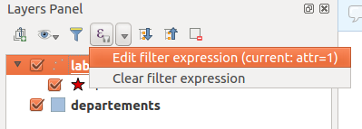
This feature was funded by Agence de l’Eau Adour-Garonne (Adour-Garonne Water Agency)
Ezt a funkciót fejlesztette: Hugo Mercier / Oslandia <http://oslandia.com>`__
Térkép összeállítás
Feature: New options for filtering legend elements
This introduces two new options to filter legend elements.
The first, filter by expression, allows users to set an expression for filtering which features should be shown in the legend. Only symbols with a matching feature will be shown in the legend.
The second filter option allows a composer legend to be filtered to include only items which are contained within the current atlas polygon.
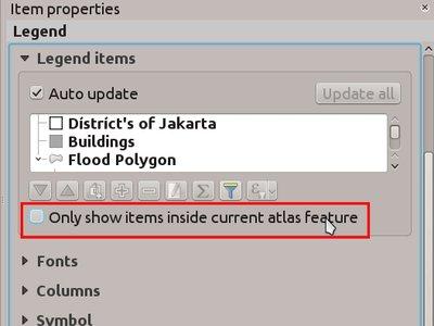
This feature was developed by Hugo Mercier (Oslandia)
Feature: Additional paths for composer templates
You can now define custom paths that should be used for QGIS to find
composer templates. This means that you can for example put a bunch of
templates in a network share and give your users access to that folder
in addition to the local ones that exist on their own system. To manage
the composer template search paths, look in
Settings -> Options -> Composer
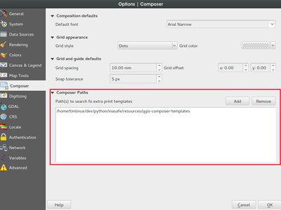
Ezt a funkciót Nathan Woodrow fejlesztette
Feature: Multiple selection of compositions in manager
The Composer Manager has gained support for managing multiple compositions at the same time. You can now open or delete multiple compositions at once by using the Ctrl key and selecting multiple compositions from the list.
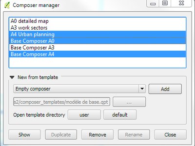
Ezt a funkciót fejlesztette: Médéric Ribreux
Modulok
Feature: Authentication system support for plugin manager
Support for the new authentication system has been added to the plugin manager. This allows users to apply authentication configurations for connections to plugin repositories, and system administrators to create authenticated access to plugin repositories and/or the download packages of plugins.
This feature was funded by Boundless Spatial
Ezt a funkciót fejlesztette: Larry Shaffer
Feldolgozás
Feature: New algorithms in 2.14
QGIS geoalgorithms:
Smooth: for smoothing line or polygon layers.
Reverse line direction.
GDAL/OGR geoalgorithms:
gdal2tiles: builds a directory with TMS tiles, KMLs and simple web viewers.
gdal_retile: retiles a set of tiles and/or build tiled pyramid levels.
Feature: Unit Tests Q/A
To guarantee the long-term stability of the processing module, a new testing framework has been introduced.
Processing geo-algorithms are executed after every change which hits the QGIS source code and the result is compared to a control dataset to guarantee correct behavior. This gives an immediate feedback about possible regressions.
It is possible - and desired - that more tests are added. You can read more about how to participate.
This feature was funded by The QGIS Project
Ezt a funkciót fejlesztette Matthias Kuhn OPENGIS.ch
Feature: Improved toolbox
The simplified interface has been removed, and a new and more user-friendly system of managing providers has been added. The algorithm search functionality now also searches in providers that are not active, and suggests activating them.
This feature was funded by Boundless Spatial
Ezt a funkciót fejlesztette: Víctor Olaya
Feature: Batch processes can be saved and later recovered from the batch processing interface
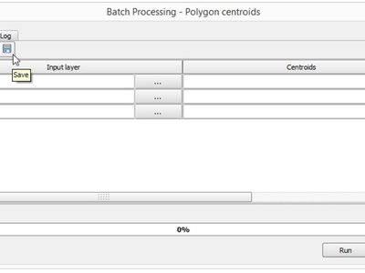
Funkció: Informatívabb algoritmus párbeszédablak
A short description is now shown along with the algorithm parameters, making it easy to understand the purpose of the algorithm.
Also, batch processes can be now started from the algorithm dialog, using the “Run as batch process…” button
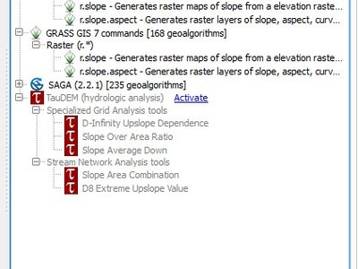
Funkció: GRASS 7 v.net modulok
QGIS 2.14 Processing now incorporates v.net GRASS modules (only for GRASS7). Those modules are a set of algorithms that perform on graph line vector layers (networks). A graph is a set of vertices (or nodes or points) linked together with a set of edges (or arcs or lines). The set of edges is often called a network.
Thanks to v.net modules, you can easily calculate the shortest path between a set of nodes on the network or even compute the isochrone map from a set of central points. you can also easily solve the complex travelling salesman problem from a network and a set of travel nodes.
v.net algorithms often use a line vector layer (for the network) and a point layer which represents the nodes you want to use for the computation. Be sure to use a true graph line vector layer for the network layer (edges need to be connected on vertex without intersection between edges) to avoid problems. You can also use any network layer attribute for cost calculation (the content of the attribute is used to calculate the travel cost of the edge).
Here is a quick summary of the different algorithms that have been included into Processing:
v.net.alloc: Allocates subnets from nearest centres.
v.net.allpairs: Computes the shortest path between all pairs of nodes in the network.
v.net.arcs: Creates arcs from a file of points.
v.net.articulation: Computes the articulation points in the network.
v.net.bridge: Computes bridges of the network.
v.net.centrality: Computes degree, centrality, betweenness, closeness and eigenvector centrality of each node of the network.
v.net.components: Computes strongly and weakly connected components in the network.
v.net.connect: Connects points (nodes) to nearest arcs in the network (and adds edges if necessary).
v.net.connectivity: Computes vertex connectivity between two sets of nodes in the network.
v.net.distance: Computes the shortest path via the network between two sets of nodes.
v.net.flow: Computes the maximum flow between two sets of nodes in the network.
v.net.iso: Computes the isochrone map of the network from a set of nodes.
v.net.nodes: A hálózat/gráf réteg csomópontjainak
v.net.nreports: Reports information about the nodes.
v.net.path: Finds the shortest path on the network between two nodes.
v.net.report: Reports information about the edges of the network.
v.net.salesman: Computes the travelling salesman path from a set of nodes on the network.
v.net.spanningtree: Computes the Spanning tree of the network.
v.net.steiner: Creates a Steiner tree for the network and given nodes.
v.net.visibility: Performs visibility graph construction.
Use the „Help” tab on each of the v.net Processing algorithm to read the official GRASS7 documentation directly for more information.
Ezt a funkciót fejlesztette: Médéric Ribreux
Programozhatóság
Feature: Redesign expression function editor
With auto save
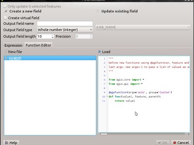
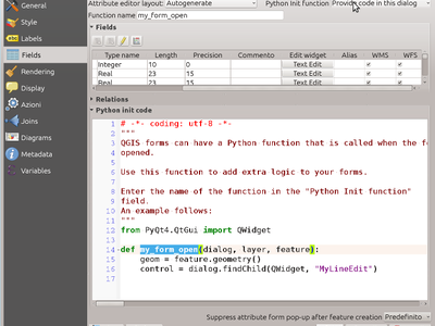
Funkció: Python inicializáló kód tárolása a projektben
Adds an option and code editor to store python form init code into the project (and the DB, since it’s in the style section)
Feature: New filtering and sorting options for QgsFeatureRequest
QgsFeatureRequest now supports setting a maximum limit for the number of features returned. In many cases this limit is passed to the provider, resulting in significant performance gains when only a set number of features are required.
Additionally, QgsFeatureRequest now supports setting ordering for returned features. Again, in many cases this ordering is delegated to the provider so that it is performed „server side” for optimal performance.
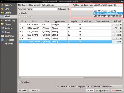
Feature: Custom feature form Python code options
This feature adds more options to the custom feature form Python code:
load from file (with file picker widget)
load from the environment (i.e. a plugin or a Python init function)
directly enter the code in an input widget (new option)
The configuration options, including the custom Python code entered in the dialog are stored in the project as well as in the style QML settings and can be exported/restored from a DB.
This feature was funded by ARPA Piemonte
This feature was developed by Alessandro Pasotti (ItOpen)
Funkció: Új PyQGIS osztályok a 2.14-ben
Új belső osztályok
QgsAttributeEditorElement - abstract base class for any elements of a drag and drop form
QgsAttributeEditorContainer - container for attribute editors, used to group them visually in an attribute form
QgsAttributeEditorField - element for loading a field’s widget onto a form
QgsAttributeEditorRelation - element for loading a relation editor widget onto a form
QgsEditFormConfig - stores and sets configuration parameters for attribute editor forms
QgsFeatureFilterProvider - provides an interface for modifying a QgsFeatureRequest in place to apply additional filters to the request
QgsTracer - provides graph creation and shortest path search for vector layers
QgsTransactionGroup - interface for grouping layers into single edit transactions
QgsUnitTypes - helper functions for various unit types and conversions between units (eg distance and area units)
QgsVirtualLayerDefinition - class for manipulating the definitions of virtual layers
QgsVirtualLayerDefinitionUtils - helper utilities for working with QgsVirtualLayerDefinition objects
Qgs25DRenderer - 2.5D symbol renderer
QgsGeometryGeneratorSymbolLayerV2 - geometry generator symbol layer
QgsFeatureRequest.OrderByClause - class for specifying a field sort order for feature requests
QgsFeatureRequest.OrderBy - a prioritized list of order by clauses for sorting
Új GUI osztályok
Újra használható vezérlők:
QgsExternalResourceWidget - widget for displaying a file path with a push button for an „open file” dialog, and optional display of pictures or HTML files
QgsFileWidget - widget for selecting a file or a folder
QgsLegendFilterButton - tool button widget that allows enabling or disabling legend filter by contents of the map
QgsMapCanvasTracer - an extension of QgsTracer that provides extra functionality for interacting with map canvases
Qgs25DRendererWidget - widget for setting properties for a 2.5D renderer
QgsColorWidgetAction - widget action for embedding a color picker inside a menu
Újrahasznosítható párbeszédablakok:
QgsStyleV2GroupSelectionDialog - dialog for grouping selections in a style
QgsGroupWMSDataDialog - dialog for setting properties for a WMS group
QgsOrderByDialog - dialog for specifying sort ordering of fields
QGIS szerver
Feature: STARTINDEX param in WFS GetFeature Request
`STARTINDEX is standard in WFS 2.0, but it’s an extension for WFS
1.0 implemented in QGIS Server.
STARTINDEX can be used to skip some features in the result set and
in combination with MAXFEATURES provides for the ability to use WFS
GetFeature to page through results. Note that STARTINDEX=0 means
start with the first feature, skipping none.
Ezt a funkciót fejlesztette: 3Liz
Feature: showFeatureCount in GetLegendGraphic
Add non-standard parameter showFeatureCount to add feature count in the legend. To activate it,showFeatureCount can be set to TRUE or 1.
This feature needs a fake X server.
Ezt a funkciót fejlesztette: 3Liz
Feature: Option to avoid rendering artefacts at edges of tiles
Funkció: Konfiguráció ellenőrző a projekt tulajdonságokban
To assist with configuring a project for QGIS Server, a new configuration checker has been added to project properties.
The checker tests for errors like:
duplicate names or short names used as OWS names
invalid OWS names
missing vector layer encodings

This feature was funded by Ifremer
Ezt a funkciót fejlesztette: 3Liz
Feature: WMS INSPIRE Capabilities
In the project properties the user can:
activate INSPIRE capabilities
select the language for the service, from 24 EU official languages + 5 regional languages
choose the scenario for service metadata and specify their parameters
The WMS 1.3.0 capabilities reflects the INSPIRE configuration.
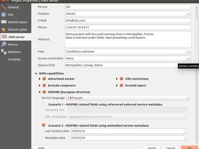
Ezt a funkciót fejlesztette: 3Liz
Funkció: Rövid név megadás rétegekhez, csoportokhoz és projekthez
A number of elements have both a Name and a Title. The Name is a text string used for machine-to-machine communication while the Title is for the benefit of humans. For example, a dataset might have the descriptive Title Maximum Atmospheric Temperature and be requested using the abbreviated Name ATMAX.
Users can already set a title for layers and project. OpenGeospatial Web Services, OWS (WMS, WFS, WCS), name is based on the name used in the layer tree. This name is more a label for humans than a name for machine-to-machine communication.
To add the capability for users to define Name as a text string for machine-to-machine communication, this feature adds:
short name line edits to layer properties
WMS data dialog to layer tree group (short name, title, abstract)
short name line edits to project properties
add a regexp validator „^[A-Za-z][A-Za-z0-9._-]*” to short name line edit accessible through a static method
add a TreeName element in the fullProjectSettings
If a short name has been set for layers, groups and project it is used by QGIS Sever as the layer name.
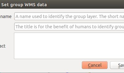
Ezt a funkciót fejlesztette: 3Liz
Jelrendszer
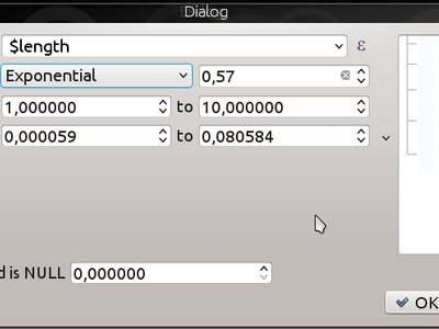
Feature: Size assistant for varying line width
Funkció: Az átlátszóság támogatása az SVG szín paraméterek között
Non-bundled SVGs must add:
fill-opacity="param(fill-opacity)"
és
stroke-opacity="param(outline-opacity)"
to enable transparency support.
Ezt a funkciót fejlesztette:** Nyall Dawson
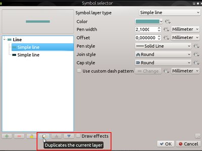
Feature: Easy duplication of symbol layers
A new „duplicate” button has been added to the symbol properties dialog, which allows symbol layers to be easily duplicated.
Ezt a funkciót fejlesztette:** Nyall Dawson
Feature: 2.5D Renderer
This adds a configuration interface and renderer that makes it easy to put all the pieces together which are required to get a 2.5D effect.
It allows for configuring some of the styling and is meant to create an easy-to-use setup.
Since every part of the system is built around QGIS» internal rendering and symbology engine, there is much to fine tune. To get all the possibilities, just change the renderer to a graduated, categorized or single symbol renderer upon creation and you will find full access to improve the style to your needs.
Ezt a funkciót fejlesztette:
Matthias Kuhn OPENGIS.ch
This feature was funded by:
Regional Council of Picardy
ADUGA
Ville de Nyon
Wetu GIT cc
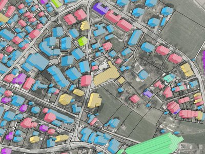
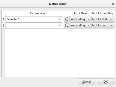
Funkció: A térképi elemek rajzolási sorrendjének megadása
When features are required to be rendered in a particular order, this can be specified by using an arbitrary expression.
This can be configured in the layer’s symbology configuration dialog and can be a simple field or a complex expression.
It also provides control over ascending or descending order as well as whether NULLs are first or last.
If possible, the request will be sent to the database (this depends on the complexity of the expression as well as the provider for the layer). If it is not possible to send the request to the database, the ordering will be performed on the local machine.
This is used by the 2.5D renderer to render features based on their distance from the „camera”.
Ez a modulokhoz is elérhető:
layer.getFeatures( QgsFeatureRequest().setOrderBy( 'name' ) ) -- alphabetical by name
Ezt a funkciót fejlesztette: Matthias Kuhn OpenGIS.ch Ezt a funkciót finanszírozta: Regional Council of Picardy, ADUGA, Ville de Nyon, Wetu GIT cc
Ezt a funkciót fejlesztette Matthias Kuhn OPENGIS.ch
Feature: Geometry generator symbols
Geometry generator symbols allow using the expression engine to modify the geometry before rendering or even creating new geometries while rendering based on feature attributes.
This can use all kinds of spatial operators like buffer, translate, intersect or extrude with parameters based on attributes only for the rendering without actually modifying the data in the source.
Példák
Translate a geometry
Used for the roof of the 2.5D renderer
translate( $geometry, 10, 10 )
Fill style for polygon border
This generates a polygon which represents the outline of the original polygon (Example image)
difference( buffer( $geometry , 250 ), buffer( $geometry, -250 ) )
Different symbol layers can contain different geometry generators, this allows displaying different versions of a geometry at the same time. The 2.5D renderer serves as an example.

Ezt a funkciót finanszírozta a Regional Council of Picardy, ADUGA, Ville de Nyon, Wetu GIT cc
Ezt a funkciót fejlesztette Matthias Kuhn OPENGIS.ch
Felhasználói interfész
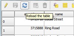
Funkció: Attribútum tábla frissíthető
Egy opció az attribútumok újratöltése az attribútum táblából most elérhető.
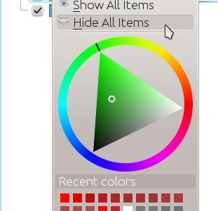
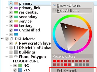
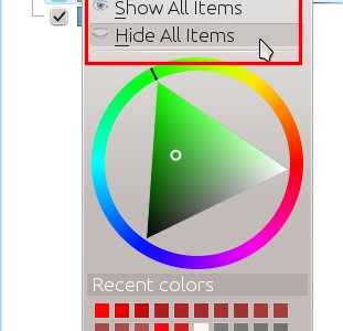
Feature: Directly set renderer and class symbol colors from context menu in legend
Shows a color wheel widget in the menu, which allows you to edit the color for a symbol interactively without even having to even open a single dialog!
Ezt a funkciót fejlesztette:** Nyall Dawson
Funkció: Jelmagyarázat szimbólumok szerkesztése közvetlenül a réteg fából
This adds a new „edit symbol” item to the right-click menu for a renderer child legend item (eg categories for the categorised renderer). Selecting it opens a symbol editor dialog which allows for directly editing the class’s symbol. It’s much faster than opening the layer properties and going through the style tab. You can also double-click on a child item to open the symbol editor immediately.
Ezt a funkciót fejlesztette:** Nyall Dawson
Feature: Show/hide all legend items via the context menu
Allows toggling on/off all the symbol items for categorized/graduated/rule-based layers via the right click menu on an item. Previously you’d have to toggle each item manually one-by-one.
Ezt a funkciót fejlesztette:** Nyall Dawson