Modifications apportées par QGIS 3.20

Date de publication : 18/06/2021
QGIS 3.20 Odense dispose d’un écran de démarrage qui affiche une section de la plus ancienne carte de la troisième plus grande ville du Danemark, Odense de 1593. La carte a été publiée par Georg Braun (1541-1622) dans l’ouvrage Civitates orbis terrarum (Cities of the World). Les cartes de Georg Braun sont toutes très belles et ont été, pour l’époque, réalisées à un haut niveau cartographique. Civitates orbis terrarum a longtemps été la principale source de cartes des villes du monde, telles que Paris, Londres, Mexico City et Aden.
Le nom Odense signifie littéralement “le temple d’Odin”, et l’endroit était peut-être à l’origine un sanctuaire du dieu païen Odin. En bas à gauche de la carte, vous voyez les ruines d’une des grandes forteresses en forme d’anneau de l’ère viking, qui ont été construites au Danemark par le roi viking danois. Harald Bluetooth (mort vers 985/86). La forteresse circulaire d’Odense s’appelle Nonnebakken.
Cette version introduit une multitude de changements subtils et de mises à jour de stabilité, renforçant le vaste catalogue de fonctionnalités de pointe introduites dans les dernières versions de QGIS. Cette version comprend de nombreuses améliorations de la gestion des données, avec quelques modifications avancées de la gestion et de l’affichage des systèmes SCR et des informations de projection. Parmi les améliorations apportées à la gestion des SCR figurent la prise en charge basique de l’époque des coordonnées des systèmes SCR dynamiques et des avertissements avancés sur l’intégrité de la précision, ce qui place QGIS 3.20 clairement à la pointe des SIG et des pratiques de gestion des données pour les systèmes de haute précision.
En outre, les utilisateurs peuvent s’attendre à une amélioration de la gestion et du traitement des métadonnées pour certains types de données et de métadonnées. Un autre point fort est l’intégration native du service de géocodage nominatim, qui permettra aux utilisateurs de rechercher des lieux et des adresses en utilisant les données du projet OpenStreetMap directement à partir de la barre de localisation de QGIS.
La communauté QGIS a également constaté un regain d’activité dans le QGIS HUB, ainsi que dans les journées portes ouvertes virtuelles de QGIS, avec la Cutting Edge Open Day présentant un certain nombre de démonstrations qui exploitent les riches fonctionnalités de QGIS introduites dans les versions plus récentes.
Nous souhaitons également remercier grandement les développeurs, rédacteurs de documentation, testeurs et tous ceux qui ont volontairement donné du temps (ou financé des gens) pour rendre possible la sortie de cette version. La communauté QGIS espère que vous apprécierez cette version ! Si vous souhaitez donner un peu de votre temps, d’argent ou vous impliquer d’une autre manière pour rendre QGIS encore plus génial, faites un tour sur QGIS.ORG et donnez nous un coup de main !
QGIS est soutenu par des donateurs et des sponsors. Une liste actuelle des donateurs qui ont apporté des contributions financières, grandes et petites, au projet peut être consultée sur notre liste de donateurs. Si vous souhaitez devenir sponsor officiel du projet, veuillez visiter notre page de parrainage pour plus de détails. Le parrainage de QGIS nous aide à financer nos réunions régulières de développeurs, à maintenir l’infrastructure du projet et à financer les efforts de correction de bogues. Une liste complète des sponsors actuels est fournie ci-dessous - merci à tous nos sponsors!
QGIS est un logiciel gratuit et vous n’avez aucune obligation de payer quoi que ce soit pour l’utiliser - en fait, nous voulons encourager les personnes de tous horizons à l’utiliser quel que soit l’état de leurs finances ou leur statut social - nous croyons que mettre à disposition un outil géographique de prise de décisions concourra à une meilleure société pour l’humanité entière.
Général
Fonctionnalité: Options supplémentaires d’ouverture des tables attributaire
Les raccourcis précédemment disponibles pour ouvrir les tables d’attributs, utiliser des filtres pour afficher uniquement les éléments sélectionnés ou les éléments visibles dans la carte, ont été intégrés dans la barre d’outils du menu afin de faciliter leur utilisation et d’améliorer l’expérience de l’utilisateur, notamment lorsqu’il travaille avec de grands ensembles de données.
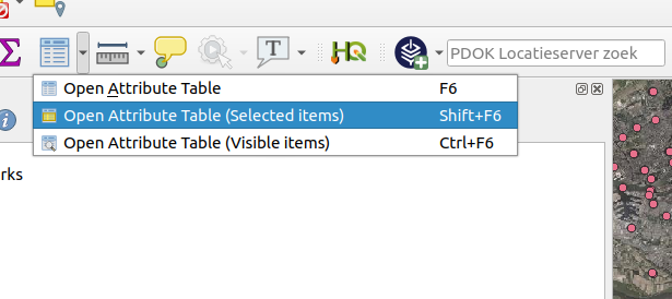
Cette fonctionnalité a été développée par Raymond Nijssen
Fonctionnalité: Définir la taille de toutes les colonnes de la table attributaire
La possibilité de « définir la largeur » et la « taille automatique » des colonnes a été étendue pour appliquer le redimensionnement d’un champ à toutes les colonnes.
Cela inclut la possibilité de définir une largeur fixe ou de « redimensionner automatiquement » toutes les colonnes. Ces actions sont disponibles dans le menu contextuel de l’en-tête de la table des attributs, accessible par un clic droit sur l’en-tête d’un champ.
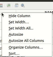
Cette fonctionnalité a été développée par Ben Wirf
Fonctionnalité: Exportation/importation de configurations d’authentification simplifiées
À partir de QGIS 3.20, les utilisateurs peuvent désormais exporter et importer facilement des configurations d’authentification via une paire d’actions dans le panneau d’authentification des paramètres de QGIS. Les configurations exportées peuvent être protégées par un mot de passe pour éviter la fuite d’informations sensibles.
Cela facilite grandement le partage de diverses configurations d’authentification entre plusieurs utilisateurs de QGIS, en particulier lorsqu’il s’agit de méthodes de configuration plus complexes telles que oauth2.
Cette fonctionnalité a été financée par la Ville d’Yverdon-les-Bains
Cette fonctionnalité a été développée par Mathieu Pellerin
Temporel
Fonctionnalité: Intervalles de navigation temporelle
Une option d’intervalles de navigation temporelle pour les « timestamps sources » a été ajoutée au contrôleur temporel. Lorsqu’elle est sélectionnée, cela permet à la navigation temporelle de passer d’un intervalle de temps disponible à un autre à partir des couches du projet. C’est utile lorsqu’un projet contient des couches avec des temps disponibles non contigus, comme un service WMS-T qui fournit des images disponibles à des dates irrégulières. Cette option permet aux utilisateurs de passer d’un intervalle de temps à l’autre uniquement lorsque la prochaine image disponible est affichée.
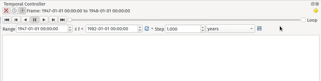
Cette fonctionnalité a été financée par Natural resources Canada Contract: 3000720707
Cette fonctionnalité a été développée par Nyall Dawson
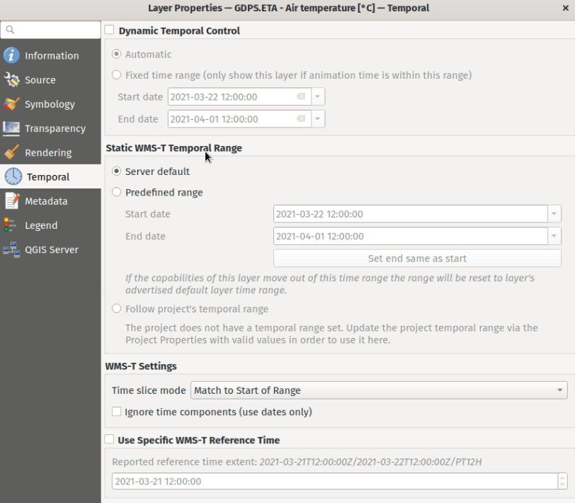
Fonctionnalité: Amélioration des paramètres de WMS-T
Les paramètres de WMS-T ont été simplifiés et des contrôles ont été introduits pour faciliter la sélection de l’heure souhaitée pour certains fournisseurs.
Des modifications ont été apportées afin d’atteindre les résultats suivants :
Rendre plus clair ce que contrôle exactement chacun des paramètres.
Rendre plus claire l’interaction et les relations entre les différents paramètres.
Indiquer clairement quels paramètres s’appliquent, que la couche soit contrôlée par le contrôleur temporel ou que les paramètres ne concernent que les couches WMS-T statiques.
Pour les serveurs qui exposent un ensemble non contigu d’instances de date-heure, au lieu d’une plage de dates, une boîte combo est fournie, ce qui évite de devoir saisir manuellement des dates valides.
Exemple de paramètres avec un serveur exposant une gamme de dates disponibles :
Exemple de paramètres avec un serveur exposant uniquement une liste d’instances de date disponibles :
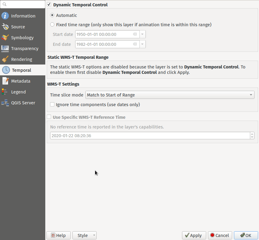
Cette fonctionnalité a été financée par Natural resources Canada Contract: 3000720707
Cette fonctionnalité a été développée par Nyall Dawson
Outils cartographiques
Fonctionnalité : Intégration du géocodeur Nominatim
Le géocodeur Nominatim est désormais intégré nativement à QGIS ! QGIS fournit un filtre de localisation Nominatim, ainsi que l’outil de traitement « Batch Nominatim Geocoder » pour le géocodage de localisations par lots.
Filtre localisateur Nominatim
Le widget de la barre de localisation de QGIS (par défaut, la barre de recherche dans le coin inférieur gauche CTRL+K) prend désormais en charge les recherches par géocode Nominatim en utilisant le préfixe “>”.
Les utilisateurs peuvent désormais rechercher des lieux en utilisant le format « > chaîne de recherche » dans le localisateur et une sélection de résultats leur sera proposée. La sélection d’un résultat de recherche repositionnera l’étendue de la carte sur cet emplacement.
Geocoder en masse avec Nominatim
En outre, un nouvel algorithme de « Géocodage en masse avec Nominatim » a été ajouté à la boîte à outils de traitement QGIS sous Outils vecteur, permettant aux utilisateurs de géocoder plusieurs lieux à la fois.
Nominatim est un service de géocodage qui utilise les données du projet OpenStreetMap. Des limitations d’utilisation et de débit - 1 requête par seconde - s’appliquent conformément aux politiques d’utilisation de la Fondation OpenStreetMap (OSMF), et les données sont fournies selon les termes de la licence ODbl. En outre, les requêtes adressées au service Nominatim peuvent inclure des informations télémétriques.
La livraison par défaut de ce grand service de géocodage n’aurait pas été possible sans la générosité et la participation de l’OSMF.
Cette fonctionnalité a été développée par Mathieu Pellerin
Interface utilisateur
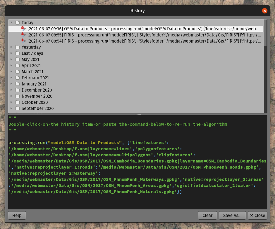
Fonctionnalité: Améliorations de la boîte de dialogue de l’historique du traitement
La boîte de dialogue de l’historique du traitement a subi une série d’améliorations de l’interface utilisateur, notamment le regroupement des algorithmes dans des structures de dossiers significatives et l’utilisation d’icônes d’algorithmes individuels. La recherche de l’algorithme que vous avez exécuté la semaine dernière n’a jamais été aussi facile !
Cette fonctionnalité a été développée par Mathieu Pellerin
Fonctionnalité: Icônes des couches cartographiques dans la boîte de dialogue de création d’expressions
La boîte de dialogue de création d’expressions affiche désormais des icônes de couche de carte à côté de la liste des couches dans le groupe parent « Couches de carte ». Cela accélère la navigation dans la liste et fournit un contexte supplémentaire.
Cette fonctionnalité a été développée par Mathieu Pellerin
Fonctionnalité: Filtrage dans les navigateurs SVG
L’interface du navigateur SVG prend désormais en charge le filtrage à base de texte, permettant aux utilisateurs de filtrer les images SVG disponibles en fonction d’une chaîne de recherche donnée.
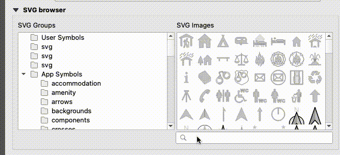
Cette fonctionnalité a été développée par Denis Rouzaud
Symbologie
Fonctionnalité: type de symbole de couche interpolation linéaire pour couches vecteur
QGIS fourni un nouveau type de style de couche « Interpolation Linéaire », qui permet un rendu de ligne variable par couleur et/ ou taille.
Ce symbole est hautement configurable et permet aux utilisateurs d’associer des attributs ou des expressions à chaque extrémité de ligne ou de courbe, parmi d’autre options de configuration. Les valeurs sont interpolées le long de la ligne entre les extrémités. La couleur se configure grâce à un widget d’ombre de rampe de couleur.
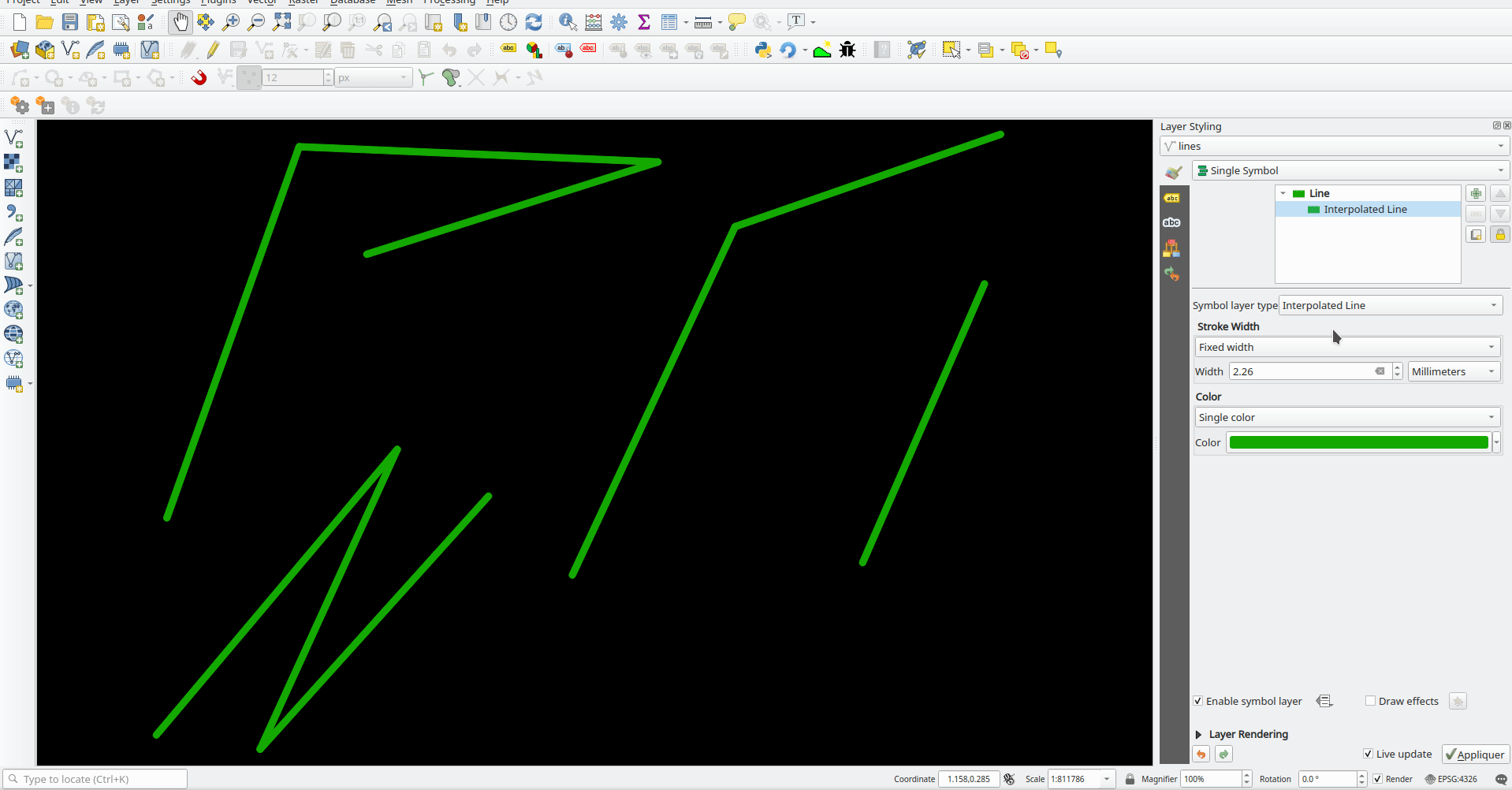
Cette fonctionnalité a été financée par Lutra Consulting
Cette fonctionnalité a été développée par Vincent Cloarec
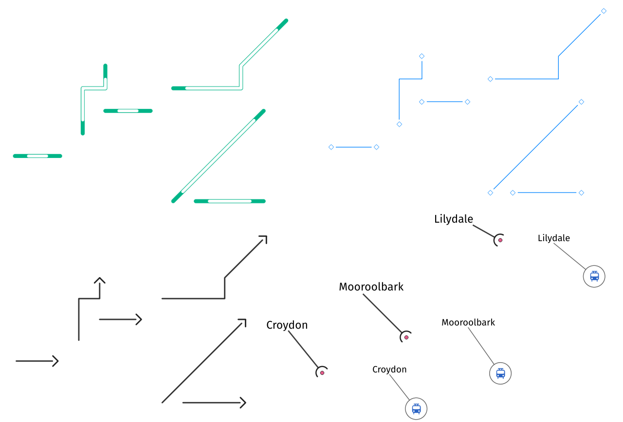
Feature: Trim the simple line symbol
An option to trim the start and end of simple line symbols was added, allowing for the line rendering to trim off the first and last sections of a line at a user configured distance. It is useful for creating complex symbols where a line layer should not overlap marker symbol layers placed at the start or end positions of a line feature, such as with transport routes. The trim distance supports a range of units, including a percentage of the overall line length, and can also be configured as a data-defined property.
A sample gallery of this functionality in use:

Cette fonctionnalité a été développée par Nyall Dawson
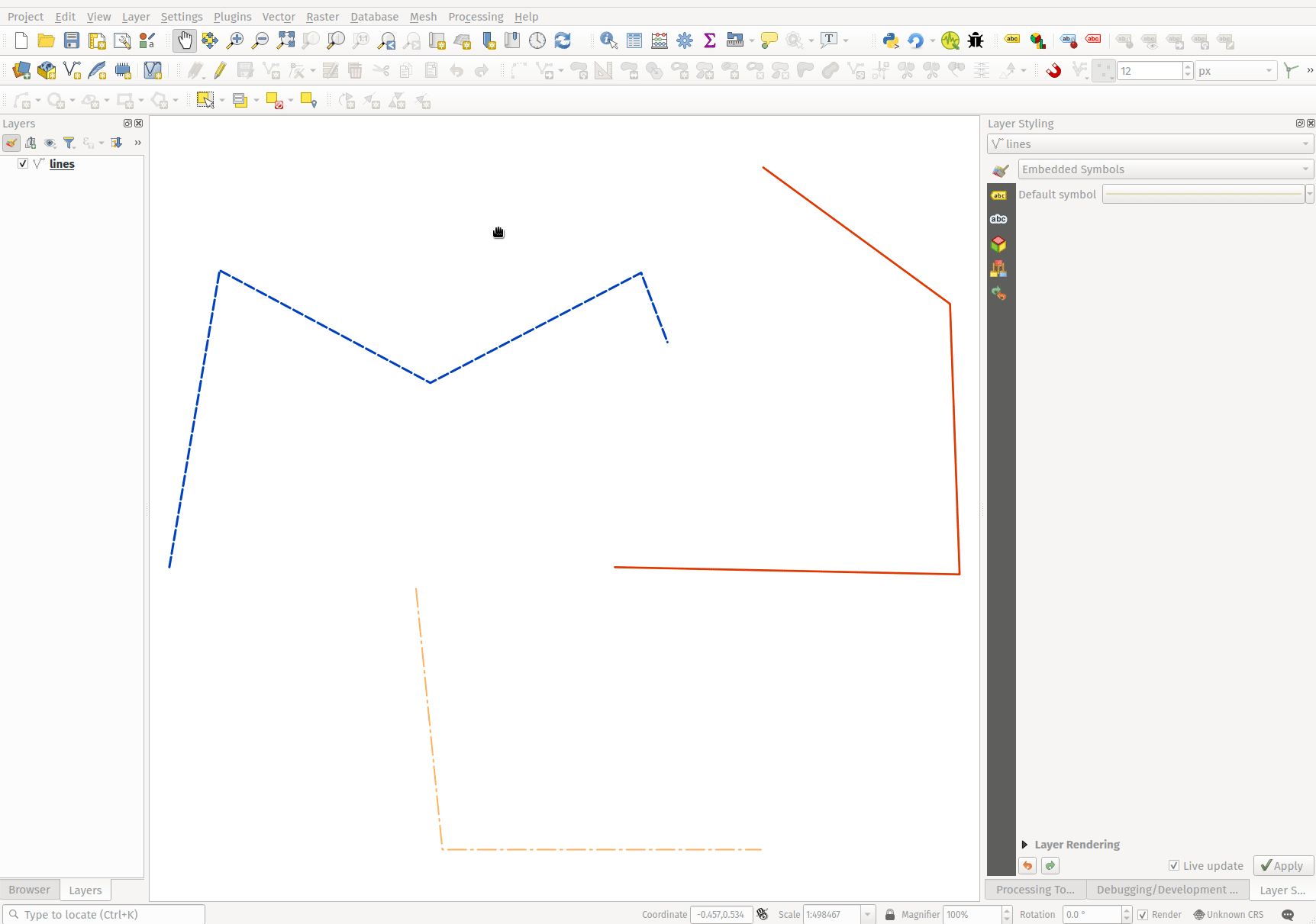
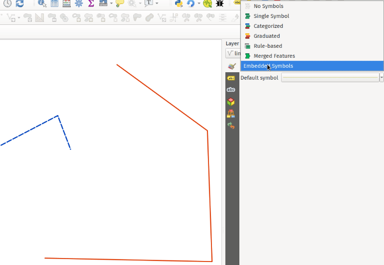
Feature: New « Embedded styling » renderer with OGR feature styles support
A new « Embedded styling » renderer has been added which exposes OGR feature styles, allowing QGIS to automatically symbolize data from certain datatypes which have integrated style information, such as KML or TAB files.
Cette fonctionnalité implémente la QEP-209
Support should extend automatically to all GDAL drivers which implement the OGR feature style API.
Currently only supports line symbol conversion, but point and polygon symbol support is under development.
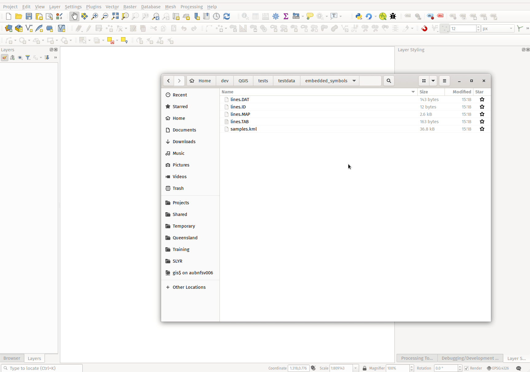
This functionality also supports the direct conversion of embedded symbol renderers into categorized or rule-based renderers. This enables QGIS to automatically create categories or rules which define symbology based on the relevant feature IDs:
Cette fonctionnalité a été financée par QGIS Denmark user-group
Cette fonctionnalité a été développée par Nyall Dawson
Feature: New shapes and cap styles for ellipse markers
Several new shapes - semi arc and arrow signs - were added to the ellipse marker symbol layer, as well as a setting to modify the cap style for stroke-only ellipse shapes.
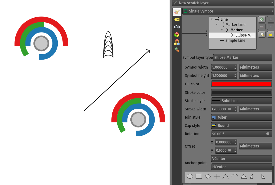
Cette fonctionnalité a été développée par Mathieu Pellerin
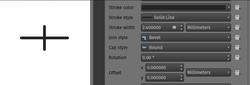
Feature: Set cap styles for simple markers
QGIS now allows for the pen cap (or line ending) style to be set for simple marker symbol layers, which is useful for the stroke-only symbols like cross and arrowhead markers, where it’s beneficial to allow the use of round caps instead of square caps.
Cette fonctionnalité a été développée par Nyall Dawson
Feature: Allow pen cap style to be set for ellipse marker symbol layers
Ellipse markers now also include support for modifying the pen cap (line ending) styles
Cette fonctionnalité a été développée par Mathieu Pellerin
Feature: Polygon rings @geometry_ring_num variable
A new variable, @geometry_ring_num, has been added for data-defined styling when rendering polygon rings. The variable is available whenever a polygon outline is being rendered, such as a simple line or marker line. This data-defined property will be set to 0 for the exterior ring, and increment accordingly (1, 2, 3… etc) for successive interior rings.
Cette fonctionnalité a été développée par Nyall Dawson
Étiquetage
Feature: Fill symbols for label background shields
Label shields can now use fill symbols for the rectangle, square, circle, and ellipse shapes.
This extends beyond the previously available ability for these shields to utilize simple fill and stroke and grants the ability to leverage the complete symbology capabilities of QGIS for shield rendering, including the utilization of « saved styles ».
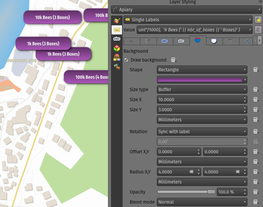
Cette fonctionnalité a été développée par Mathieu Pellerin
Feature: Blending mode settings for label callouts
Label callouts can now leverage the advanced blending modes from QGIS
Cette fonctionnalité a été développée par Mathieu Pellerin
Feature: Anchor line labels by entire line
In previous versions, when an anchor position for a line label was calculated, QGIS would only consider the visible extent of the feature. This affected the expected label position in some cases, and a new « Use Entire Line » setting allows users to configure the behavior according to their needs, so that the entire feature may be considered before label placement rather than just the portion of a feature that is currently visible.
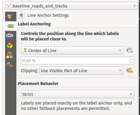
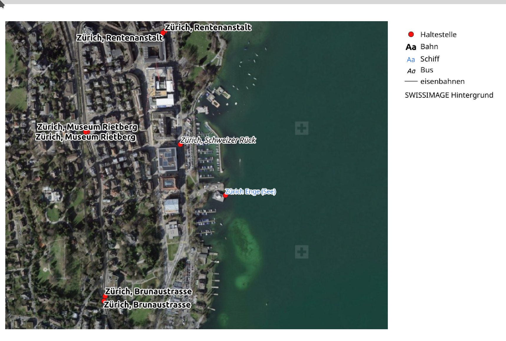
Cette fonctionnalité a été financée par Stadt Zürich
Cette fonctionnalité a été développée par Nyall Dawson
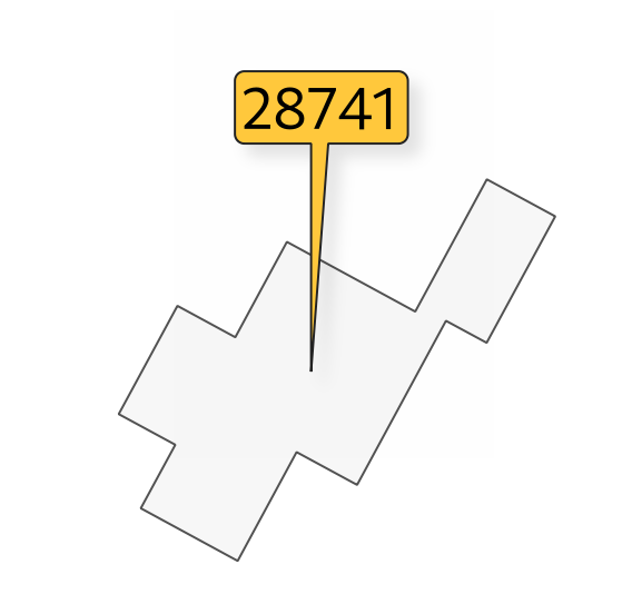
Feature: Balloon callout corner radius
Balloon callout styles now support rounded corners by introducing a « corner radius » option, resulting in the ability to easily produce visually pleasing designs.
Cette fonctionnalité a été développée par Nyall Dawson
Feature: Balloon (speech bubble) callouts
A new « balloon », or speech bubble, callout style is provided for labels.
Cette fonctionnalité a été financée par SLYR
Cette fonctionnalité a été développée par Nyall Dawson
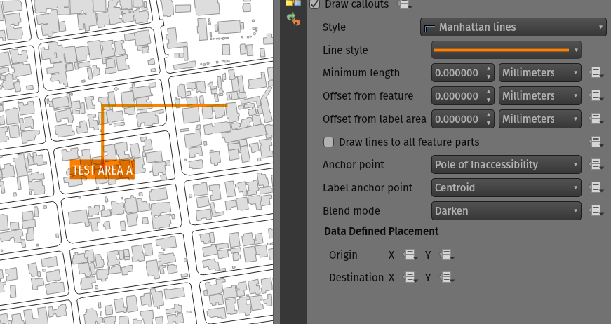
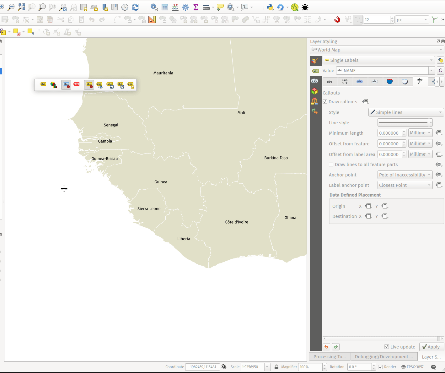
Feature: Curved line callout style
A new « Curved Line » callout style has been provided for creating cartographically pleasing curved line callouts between the labels and features
Les options incluent :
Selecting a specific curve orientation (clockwise or counterclockwise)
Automatic orientation option which determines optimal orientation for each individual label
Control over the amount of curvature applied to the callout lines.
Cette fonctionnalité a été développée par Nyall Dawson
Feature: Highlight pinned callout start or end points
When the « show pinned labels » option is enabled, QGIS will now also highlight any pinned callout start or end points. This allows users to immediately see which callouts points have been manually placed in relation to those that are automatically placed.
Cette fonctionnalité a été développée par Nyall Dawson
Feature: Auto-creation of callout auxiliary fields
QGIS now automatically manages the creation of callout auxiliary fields when attempting to move a callout start or end point interactively, making the user experience for moving a callout follow the exact same behavior as that of moving a label, preventing the system from forcing users to create auxillary fields in advance.
Cette fonctionnalité a été développée par Nyall Dawson
Feature: Callout snapping
When interactively moving a callout line, holding the shift button will now cause the callout to snap angles at increments of 15 degrees
Cette fonctionnalité a été développée par Nyall Dawson
Feature: Toggle label layers shortcut
A shortcut action to toggle labeling has been added to the context menu of vector layers in the layer panel. This allows for labels to be quickly switched on or off, without losing the label configuration. If a layer has never had labeling configured and the action is checked, then QGIS will attempt to apply a simple labeling configuration to the layer using default parameters.
Cette fonctionnalité a été financée par Natural resources Canada Contract: 3000720707
Cette fonctionnalité a été développée par Nyall Dawson
Feature: Data defined callout start and end points
Label callout lines can now have data-defined starting and ending points, useful for manual control of the exact placement for individual callout lines.
Cette fonctionnalité a été développée par Nyall Dawson
Permettre aux légendes d’être déplacées de manière interactive à l’aide de l’outil Déplacer l’étiquette.
Cette modification permet à l’outil interactif « Déplacer les étiquettes » de déplacer également les points d’extrémité, lorsque les champs d’origine ou de destination définis par les données sont définis pour la commande.
Cette fonctionnalité a été développée par Nyall Dawson
Point Clouds
Feature: Support for remote datasets (EPT)
Les ensembles de données de nuages de points qui ont été traités au format EPT peuvent être chargés à partir de serveurs HTTP(S) distants, de manière similaire au fonctionnement des tuiles raster/vectorielles. De cette façon, il est possible d’accéder à de grands ensembles de données de nuages de points sans avoir à les télécharger au préalable sous forme de fichiers LAS/LAZ. Le format EPT est optimisé pour les tuiles et le streaming, de sorte que QGIS ne télécharge que les petites quantités de données nécessaires à l’affichage de la vue et de la résolution actuelles. Cela fonctionne à la fois en vue 2D et 3D.
Si vous disposez d’ensembles de données de nuages de points au format LAS/LAZ, ceux-ci peuvent être convertis en EPT à l’aide de la méthode suivante Entwine ou Untwine (livrées également avec QGIS).
How to use: in Data Source Manager > Point Cloud tab > select « Protocol » as the source type and enter URL of the dataset (normally ending with « ept.json »).
You can test with USGS LiDAR data - just use the link from « EPT » column from one of the datasets. Some example endpoints include:
By the way, every point cloud dataset that QGIS loads is first processed to EPT (look for « ept_XXX » sub-folder where your original data is located), so it is possible to just copy that « ept_XXX » folder to a HTTP(S) server and you are ready to use this feature.
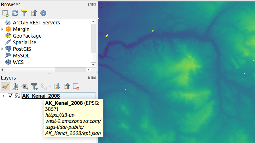
Cette fonctionnalité a été financée par Hobu
Cette fonctionnalité a été développée par Belgacem Nedjima (Lutra Consulting)
Mises en page de cartes
Feature: « Convert to Static Text » option
Lorsqu’ils utilisent des étiquettes dynamiques ou basées sur des expressions, les utilisateurs peuvent désormais sélectionner l’option « Convertir en texte statique » qui a été ajoutée au menu déroulant à côté de « Insérer/éditer une expression… », dans le widget des propriétés de l’étiquette de mise en page.
Cette option évalue et remplace toutes les parties dynamiques du contenu d’une étiquette par leurs valeurs actuelles.
Cela permet de convertir facilement les étiquettes dynamiques en étiquettes statiques, de sorte que les utilisateurs puissent modifier manuellement les résultats si nécessaire.
Cette fonctionnalité a été développée par Nyall Dawson
Feature: Improvement to XYZ layers previewed in map items
Handling of XYZ layers previewed in layout map items has been improved to ensure that their tile zoom levels match those of the exported layout while zooming in and out in the layout designer dialog. Users can now more easily refine the placement of their items (labels, legend, images, etc.) against a map preview that better matches the targeted output.
Cette fonctionnalité a été financée par Kanton Zug - Amt für Raum und Verkehr (ARV)
Cette fonctionnalité a été développée par Mathieu Pellerin
Expressions
Fonctionnalité : Fonction length3D
Une fonction « longueur 3D « a été ajoutée pour renvoyer la longueur 3D d’une géométrie de type LineGeometry. Cette fonction calcule la longueur 3D cartésienne d’un objet ligne de la géométrie. Si la géométrie n’est pas un objet ligne 3D, elle renvoie sa longueur 2D.
Cette fonctionnalité a été développée par Nyall Dawson
Feature: Extended array expression functions
The following array expressions were added:
array_count
array_prioritize
array_replace
Cette fonctionnalité a été financée par Canton of Luzern
Cette fonctionnalité a été développée par Damiano Lombardi
Feature: MIME Type expression function
The new mime_type( bytes ) expression function returns the MIME Type, or Media type, of an input bytes object
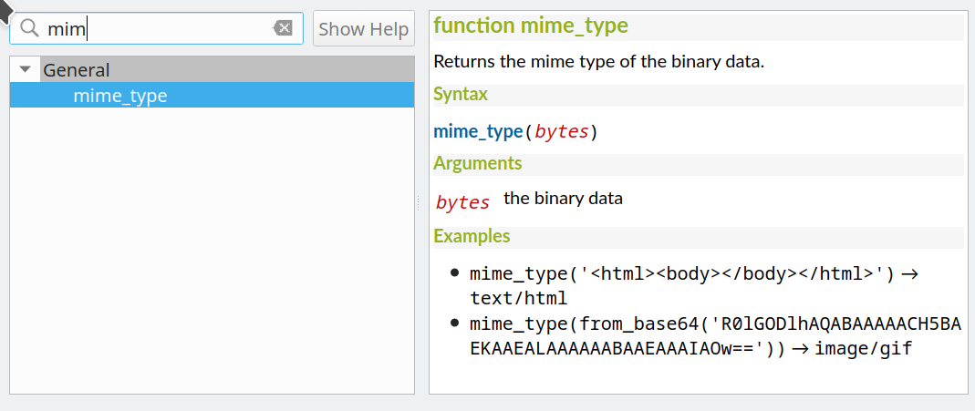
Cette fonctionnalité a été développée par Alessandro Pasotti
Numérisation
Feature: Select attributes from the largest geometry when merging
A button to select attributes from the largest geometry has been added to the confirmation dialogue when using the merge features editing tools for polygon and line layers.
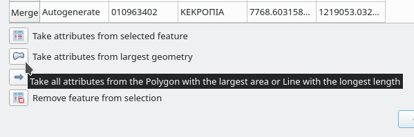
Cette fonctionnalité a été développée par Stefanos Natsis
Feature: Streaming digitizing mode
When streaming digitizing mode is active, points are automatically added following the mouse cursor movement, providing a « freehand drawing » type experience.
Using the « R » key during digitizing operations will toggle streaming digitizing and normal (or circular string) digitizing.
Works with multiple map tools, including creating new line or polygon features, add ring, add part, reshape, split features, split parts, and more.
Cette fonctionnalité a été financée par Natural resources Canada Contract: 3000720707
Cette fonctionnalité a été développée par Nyall Dawson
Feature: New « Line Endpoints » snapping option
When enabled, this snapping mode snaps to the beginning or end vertex of lines only. When snapping to a polygon layer, only the first vertex in rings will be snapped to.
Cette fonctionnalité a été financée par Natural resources Canada Contract: 3000720707
Cette fonctionnalité a été développée par Nyall Dawson
Feature: Select vertices by polygon
Users can now use the ALT button to select vertices by polygon whilst digitizing.
This should improve the user experience for selecting specific vertices using the vertex tool, reducing the need for multiple passes using The SHIFT or CTRL functions to add and remove vertices from the current selection.
This also reduces the need to creatively rotate the map canvas in order to align vertices for selection, and provides an enhanced editing process such as for selecting the vertices of a curved road along a single side only.
This function supports the following usage operations:
Alt+click using the vertex tool to start digitizing a polygon.
Each subsequent click adds a new vertex to the rubberband polygon.
Backspace/ delete removes last added rubberband vertex.
Esc cancels the polygon selection mode, as does backspace/ deleting all of the rubberband’s vertices.
Right-click finalizes the polygon digitizing and selects all vertices within the rubberband polygon.
Cette fonctionnalité a été développée par Stefanos Natsis
Gestion des données
Feature: Layer tree warning icon for layers with CRS inaccuracies
A new « Show CRS accuracy warnings for layers in project legend » is provided which, when checked, will display a new warning icon identifying any layers with a CRS which is identified as having accuracy issues.
Examples of low-accuracy layers might include those with a dynamic CRS with no coordinate epoch available, or a CRS based on a datum ensemble with accuracy that is found to exceed the user-set limit.
This option is disabled by default, and designed for use in engineering, BIM, and other industries where inaccuracies of meter/submeter level are very dangerous.
Cette fonctionnalité a été développée par Nyall Dawson
Feature: Basic support for dynamic CRS coordinate epoch
Basic support for the coordinate epoch of dynamic (not plate fixed) CRS has been added in line with relevant updates to GDAL.
QGIS has added support for respecting the source or destination coordinate epoch when transforming to or from a dynamic CRS.
If a dynamic CRS to dynamic CRS transformation at different epochs is attempted, which is not currently supported by PROJ, a user-facing warning message will be shown advising them that the results may be misleading and should not be used for high accuracy work.
Cette fonctionnalité a été développée par Nyall Dawson
Feature: Projection information improvements
Various improvements have been made to the handling and representation of projection information in QGIS, including:
The addition of an API to retrieve PROJ operation details for CRSes
The ability to show extended information about a layer’s CRS in the layer properties info tab, including accuracy warnings
The addition of a
@map_crs_projectionvariable, for retrieving a friendly name of a map’s projection (e.g. « Albers Equal Area »)
Cette fonctionnalité a été développée par Nyall Dawson
Feature: Datum ensemble CRS warnings
QGIS now shows a warning in the projection selection widget when a CRS based on a datum ensemble is selected, warning the user that there’s an inherent lack of accuracy in the selected CRS.
Cette fonctionnalité a été développée par Nyall Dawson
Feature: Persist layer metadata in vector file exports
A « persist layer metadata » checkbox has been added to the export vector file dialog. When checked, any layer metadata present in the source layer will be copied and stored in the destination file.
This functionality is enabled by default and ensures that metadata is properly transferred over to newly created items, which is especially effective when utilizing the GPKG format.
Cette fonctionnalité a été développée par Nyall Dawson
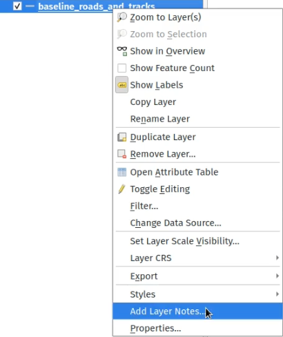
Feature: Layer notes
QGIS now supports « layer notes », which can be created via the « Add Layer Notes » action in the layer context menu.
These notes are saved per layer, per project. They can be used as a place to store important messages for project users, such as to-do lists, processing or management instructions, or any other arbitrary text-based metadata.
A notepad indicator icon in the layers panel identifies layers that have notes attached. Clicking the notes indicator icon will open the note for editing.
Cette fonctionnalité a été discutée dans la QEP-206
These notes may be copied and pasted using the traditional copy/ paste methodology for transferring styles between layers in QGIS.
Layer notes are also supported by and stored within QML (QGIS Style) and QLR (QGIS Layer Definition) files.
Cette fonctionnalité a été financée par by Alta Ehf
Cette fonctionnalité a été développée par Nyall Dawson
Feature: Automatically load .shp.xml metadata
QGIS will now automatically load and convert ESRI metadata stored using a .shp.xml sidecar file. Where shapefile data is loaded and these metadata files are present they will be loaded automatically, with available layer metadata populated accordingly.
Cette fonctionnalité a été développée par Nyall Dawson
Feature: Automatically translate layer data from ESRI Filegeodatabases to QGIS layer metadata
When loading data from a .gdb file, QGIS will automatically attempt to translate as much as possible of the original ESRI metadata across to the QGIS metadata, so that it’s immediately available for use.
Cette fonctionnalité a été financée par North Road / SLYR
Cette fonctionnalité a été développée par Nyall Dawson
Feature: Read field domains from datasets
For formats that support the embedded definition of field domains (currently GPKG and GDB), QGIS automatically converts the embedded field domain over to the equivalent QGIS editor configuration for the field.
This means that GPKG/GDB with coded field domains will automatically load into QGIS with their correct Value Map widget configuration intact, so that users see descriptions for field values instead of raw codes. Fields with a range (min/max) type domain will be translated to the range widget for the field as well.
Cette fonctionnalité a été financée par North Road
Cette fonctionnalité a été développée par Nyall Dawson
Feature: Allow loading GPKG layers with GEOMETRY type
GeoPackage supports layers with a generic « geometry » type, with the QGIS release 3.20 it is now possible to load them and specify the requested geometry type on load, just like with PostGIS.
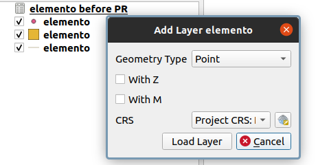
Cette fonctionnalité a été développée par Marco Bernasocchi (OPENGIS.ch)
Feature: Offline editing support for string list and number list field types
PostGIS users rejoice: offline editing got a bit smarter and can now handle string list and number list field types.
Cette fonctionnalité a été développée par Mathieu Pellerin
Formulaires et widgets
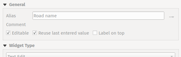
Feature: Per-field usage of last values for newly created features
Extended control has been provided for whether the last entered field values should be reused when creating new features, as this functionality may now be controlled independently for each individual attribute field for each layer.
Historically this functionality was configured using a global option that causes ALL field values for ALL layers to be remembered and reused during a QGIS session when creating new features.
This allows for finer control over form behavior, where some values may be desirable to reuse but others should be cleared or set to a default value based on an expression.
Cette fonctionnalité a été développée par Nyall Dawson
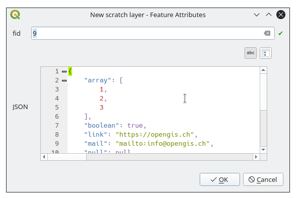
Feature: JSON View widget
New view widget to display JSON data in a user friendly way. Data can be displayed as syntax highlighted text or as a tree.
Cette fonctionnalité a été financée par Canton of Solothurn
Cette fonctionnalité a été développée par Damiano Lombardi
Légende des couches
Feature: Vector « label » legend entries
QGIS now supports adding legend entries for layer labels, which will display the font style and labeling classes for vector features.
This provides a legend entry that allows users to explicitly identify features by label style, even when no feature symbology is used.
Control of this behavior is made accessible by adding a « show label legend » option to the legend tab of the vector layer properties.
Cette fonctionnalité a été financée par Canton of Glarus
Cette fonctionnalité a été développée par mhugent
Traitement
Feature: Add option to save layer metadata to Package Layers algorithm
This additional option enriches the Package Layers algorithm and will copy the source layer metadata into the geopackage, so that it will be used as the default metadata for the layer.
Cette fonctionnalité a été développée par Nyall Dawson
Feature: Raster Layer Properties Algorithm
This algorithm retrieves basic raster layer properties such as the size in pixels, pixel dimensions (map units per pixel), number of bands, and no data value.
It is intended for use as a means of extracting these useful properties to use as the input values to other algorithms in a model, such as passing an existing raster’s pixel sizes over to a GDAL raster algorithm.
Cette fonctionnalité a été développée par Nyall Dawson
Feature: Improved rasterize operation with 3D support
The rasterize (vector to raster) GDAL process now supports 3D data, in that it now includes the possibility to use the Z value (elevation) of a feature to extract burn values.
The use of this option indicates that a burn value should be extracted from the “Z” values of the feature. Works with points and lines (linear interpolation along each segment). For polygons, it only works properly if the features are flat (i.e. contain the same Z value for all vertices)
Cette fonctionnalité a été développée par talledodiego
Feature: Save selected option for Package Layers Algorithm
The Package Layers Algorithm was modified to support saving only selected features
Cette fonctionnalité a été développée par Stefan Conrads
Feature: Log levels for processing context
A new log level property has been added to QgsProcessingContext
This allows algorithms to tune their output based on the logging level.
The qgis_process command line operation has been granted a –verbose switch to enable verbose log output.
Cette fonctionnalité a été financée par Natural resources Canada Contract: 3000720411
Cette fonctionnalité a été développée par Nyall Dawson
Feature: Geometry snapper rework offers major speed boost
This development cycle saw a rework of the inner workings of QGIS” geometry snapper algorithm, which has led to a significant speed boost. Datasets which could take over 10 minutes to process now take less than 10 seconds.
Cette fonctionnalité a été financée par SwissTierras Colombia
Cette fonctionnalité a été développée par Mathieu Pellerin
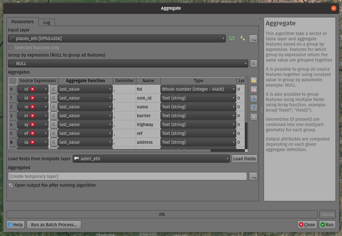
Feature: Add a last_value function to the aggregate algorithm
The aggregate processing tool now includes a last_value aggregation function, which is especially useful when working with input data that has meaningful ordering.
Cette fonctionnalité a été développée par Mathieu Pellerin
Options de l’application et du projet
Feature: Add global option to disable monitoring of directories
Allows users to manually opt-out of monitoring directories in the browser by default, and also provides a mechanism for enterprise installs to disable this potentially unwanted behavior.
Cette fonctionnalité a été développée par Nyall Dawson
Feature: APIs for export and import of XML authentication configurations
QGIS now provides export and import functions to the QGIS authentication manager. This functionality has not yet been exposed through the User Interface. Complex authentication configurations with numerous, such as OAuth2, can optionally be encrypted or stored in plain text to enhance authentication management workflows.
Cette fonctionnalité a été développée par Mathieu Pellerin
Explorateur
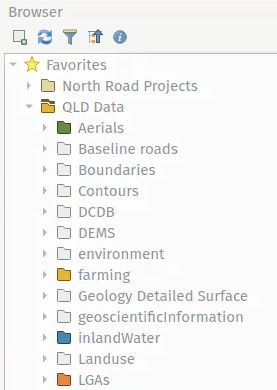
Feature: Custom icon colors for folders in browser
QGIS now allows users to set a custom icon color for different folders in the browser. This effectively allows users to « tag » folders, which aids in the rapid navigation of complex folder structures in the browser.
Cette fonctionnalité a été développée par Nyall Dawson
Feature: OWS Group removed from the QGIS Browser
The non-functional and redundant « OWS » Group has been removed from the QGIS Browser panel.
Cette fonctionnalité a été développé par Loïc Bartoletti
Fournisseurs de données
Feature: Add support for integer, real and integer64 list data types in OGR
Additional list field types have been added to the OGR driver for supported data types, such as Geojson.
Cette fonctionnalité a été développée par Nyall Dawson
Feature: Extend vector layer read capabilities to other layer types
Whilst the ability for QGIS to access a layer’s metadata information, such as reading the extent of a layer from the metadata, was previously restricted to vector layers, this functionality has now been extended to include various other layer types including raster, point cloud, and others.
Cette fonctionnalité a été financée par Ifremer
Cette fonctionnalité a été développée par rldhont
QGIS Server
Feature: External layer opacity
Opacity control support for external/ remote layers served by QGIS Server
Cette fonctionnalité a été développée par mhugent
Feature: Configurable Service URL
Additional options have been added to QGIS Server to improve the results of the GetCapabilities response, especially without the need to complete various fields within the QGIS Project configuration. These updates also enable many options to be set by an environment variable, or by providing headers from a proxy.
The following options have been added and will be resolved by the server in the following order:
Value defined in the project per service.
The
<service>_SERVICE_URLenvironment variable.The
SERVICE_URLenvironment variable.The custom
X-Qgis-<service>-Service-Urlheader.The custom
X-Qgis-Service-Urlheader.Build from the standard
Forwardedheader.Build from the pseudo standard
X-Forwarded-HostandX-Forwarded-Protoheaders.Build from the standard
Hostheader and the server protocol.Build from the server name and the server protocol.
Cette fonctionnalité a été développée par Stéphane Brunner
Correctifs notables
Fonctionnalité : Correction de bugs par Even Rouault
Intitulé du bug |
URL (if reported, Github) |
URL du commit (Github) |
Correctif rétroporté sur la 3.16 (GitHub) |
|---|---|---|---|
compiler warning in QgsMeshDatasetGroupStore::readXml() |
non signalé |
N/A |
|
QGIS plante avec GDAL 3.3 |
|||
Data corrupted when deleting field in a (specific) geopackage layer |
|||
PyQGIS: WMS-T layer uri without timeDimensionExtent in it crashes QGIS |
|||
Data Corruption: Failed GPKG OID/FID Over-write causes value to spill into next attribute column |
|||
« Split features » causes data loss |
|||
Foreign key constraints checks are ignored on GPKG |
Inapproprié |
||
Strange error message from SQL Query Composer in WFS client |
|||
WFS 1.1.0 ExceptionReport response handling : QGIS looks for “exceptionCode” but in specifications it’s “code” attribute |
|||
Export selection from a large WFS layer fails |
|||
Long (?) WKT makes delimited text layer fail on 3.16 and 3.18 |
|||
Wrong SRS when reading a Postgis layer |
non signalé |
Inapproprié |
|
Mesh data in GRIB format from ERA5 |
`PR 3877 de GDAL<https://github.com/OSGeo/gdal/pull/3877>`__ |
||
Two OGR provider filtered layers with same source dataset don’t restore proper feature count / extent on project reload |
Cette fonctionnalité a été financée par QGIS.ORG (grâce aux dons et adhésions de soutien)
Cette fonctionnalité a été développée par Even Rouault
Fonctionnalité : Bug fixes by Alessandro Pasotti
Intitulé du bug |
URL (if reported, Github) |
URL du commit (Github) |
Correctif rétroporté sur la 3.16 (GitHub) |
|---|---|---|---|
Data Source Manager fails to derive exact 3D geometry type for GeometryZ PostGIS tables |
|||
Attribute table conditional formatting doesn’t work when using $geometry is NULL |
Fonctionne pour moi |
||
QgsZonalStatistics.calculateStatistics() incomplete outputs |
|||
Bad Request on feed.qgis.org |
Not relevant |
||
Server: WFS3/API Features - overlapping columns/content on data items as HTML pages |
|||
Datum transformation using custom gsb grid for WMS Layer in QGIS Server does not work |
Not relevant |
||
Server: fix unreported QGIS_OPTIONS_PATH not really working for proj |
non signalé |
Inapproprié |
|
WFS cascade getfeatureinfo fails |
Fonctionne pour moi |
||
Server standalone: fix unreported project storage not supported with -p |
non signalé |
||
QGIS Server GetPrint: HIGHLIGHT_GEOM is not printed if map layers are configured to follow a map theme |
Risqué |
||
Feature count is wrong when adding features from a table with features of mixed geometries |
Fonctionne pour moi |
||
Not all geometry types are found in PostGIS table with Spatial Type of Geometry |
Risqué |
||
Icon not updated when saving a scratch layer |
non signalé |
||
Fix list of protocols in ssh custom configuration |
non signalé |
Inapproprié |
|
Crash with table set to Show Visible, joins, and left open as QGIS is quit |
Inapproprié |
||
« show label » is disabled in widget designer but label keeps displaying in attribute form if you use tabs in the Drag and-Drop Designer and the field widget was placed in any tab |
À faire |
||
Browser adds layers to projects with a leading space |
Inapproprié |
||
saveStyleToDatabase() bug when saving more than one layer to a GPKG |
Fonctionne pour moi |
||
Widget parameters not persistent for relations in D&D designer |
Inapproprié |
||
Rule-based rendering sometimes doesn’t show all results |
Risqué |
||
Fix unreported missing raster band stats in info panel |
non signalé |
||
Raster calculator does not create/store statistics for output rasters |
Pas prioritaire |
||
Attribute Form Value Relation Doesn’t Respect Column Default |
Fonctionne pour moi |
||
Attribute table in form view can display « ghost » attributes |
Pas prioritaire |
||
PG identity default clause issue |
https://lists.osgeo.org/pipermail/qgis-user/2021-June/048983.html |
Inapproprié |
|
Erreur 3.18.3 lors de l “ajout d’une couche wms |
À faire |
||
« Réutiliser les dernières valeurs d’attributs « ralentit la création de nouvelles éléments sur un grand vecteur |
À faire |
||
La suppression de « toutes les autres valeurs » rompt la symbologie des catégories basées sur la date |
|||
Fix documentation doctest builds |
Not relevant |
Cette fonctionnalité a été financée par QGIS.ORG (grâce aux dons et adhésions de soutien)
Cette fonctionnalité a été développée par Alessandro Pasotti
Fonctionnalité : Correction de bugs par Paul Blottiere
Intitulé du bug |
URL (if reported, Github) |
URL du commit (Github) |
Correctif rétroporté sur la 3.16 (GitHub) |
|---|---|---|---|
VERSION is now mandatory in WMS 1.3.0 for getmap requests |
non signalé |
||
WMTS GetCapabilities and axis order |
|||
Utiliser une version plus ancienne dans la négociation wms |
Risqué |
||
QGIS crashes adding a record to a memory (« scratch ») layer table in some circumstances |
Fonctionne pour moi |
||
QGIS fails silently when an auxiliary layer cannot be created |
non signalé |
||
Impossible de sauvegarder le stockage auxiliaire |
Risqué |
||
WMS GetFeatureInfo sur une couche dont le temps est activé ne fournit pas le paramètre TIME. |
Cette fonctionnalité a été financée par QGIS.ORG (grâce aux dons et adhésions de soutien)
Cette fonctionnalité a été développée par Paul Blottiere
Fonctionnalité : Correction de bugs par Denis Rouzaud
Intitulé du bug |
URL (if reported, Github) |
URL du commit (Github) |
Correctif rétroporté sur la 3.16 (GitHub) |
|---|---|---|---|
Widget parameters not persistent for relations in D&D designer |
not relevant |
||
Utiliser une édition de ligne en lecture seule au lieu d’une zone de liste déroulante dans la référence de relation ne permet pas d’ajouter un enfant au parent |
trop risqué / ne vaut pas la peine |
||
pas de formulaire ouvert dans le filtre de localisation des entités de toutes les couches (filtre actif) + afficher le formulaire au lieu de l’erreur pour les couches sans géométrie |
non signalé |
? |
|
Cannot add a polymorphic relations |
not relevant |
||
Filter expression from relation reference widget on attributes form, not working properly |
oui |
||
fix Picture layout element does not handle properly a non-existing filepath when provided with an expression |
|||
relations bug: zoom to child button disappears |
Fonctionne pour moi |
||
Value Relation and Relation reference widget: Entries are sorted although the option « Order by value » is NOT checked |
not sure how to fix this for now |
||
Errors while adding a feature with a polymorphic relation |
corrigé |
Cette fonctionnalité a été financée par QGIS.ORG (grâce aux dons et adhésions de soutien)
Cette fonctionnalité a été développée par Denis Rouzaud
Fonctionnalité : Correction de bugs par Loïc Bartoletti
Intitulé du bug |
URL (if reported, Github) |
URL du commit (Github) |
Correctif rétroporté sur la 3.16 (GitHub) |
|---|---|---|---|
QgsProjectionSelectionWidget::selectCrs() ne peut être écrasé en Python |
Fonctionne pour moi |
||
Un bug? dans FindPyQt5.py |
not relevant |
||
Missing incon of Geometry Checker core plugin |
|||
Please reomve the not functional OWS group from the QGIS browser |
Inapproprié |
||
Build fails with external qwtpolar |
|||
Check geometries tool does not save default action changes |
|||
Wrong error output location when using Check validity on data with certain type of 3D error |
Cette fonctionnalité a été financée par QGIS.ORG (grâce aux dons et adhésions de soutien)
Cette fonctionnalité a été développée par Loïc Bartoletti
Fonctionnalité : correction de bug par Julien Cabieces
Intitulé du bug |
URL (if reported, Github) |
URL du commit (Github) |
Correctif rétroporté sur la 3.16 (GitHub) |
|---|---|---|---|
Postgresql tables with intarray fields as primary key causes problems in python scripts |
|||
Cannot instantiate QgsFeatureFilterModel using PyQGIS |
|||
QGIS crashes by loading ui file |
Fonctionne |
||
QvariantList Field , nothing in attribute table when a single value is in the list |
|||
Copy CRS to clipboard when copying selected features |
|||
Open Running (connection) Task makes it impossible to Quit QGIS |
|||
Plugin manager doesn’t work with proxy |
Retour d’informations |
||
Form fails to initialize $geometry |
Cette fonctionnalité a été financée par QGIS.ORG (grâce aux dons et adhésions de soutien)
Cette fonctionnalité a été développée par Julien Cabieces
Fonctionnalité : Correction de bugs par Peter Petrik
Intitulé du bug |
URL (if reported, Github) |
URL du commit (Github) |
Correctif rétroporté sur la 3.16 (GitHub) |
|---|---|---|---|
Passwords cannot be saved into keychain on macOS with QGIS 3.16 |
feedback |
||
buggy profile results in two instances starting |
not an issue anymore |
||
GRASS plugin init error on macOS |
Fonctionne pour moi |
||
Data Source Manager incorrectly identifies PostGIS raster extent on macOS |
investigation |
||
Crash with point clouds when zooming into 3D viewer [Mac] |
not relevant |
||
Crash when chcking the « Show bounding boxes » option in 3D view settings |
backport_bot |
Cette fonctionnalité a été financée par QGIS.ORG (grâce aux dons et adhésions de soutien)
Cette fonctionnalité a été développée par Peter Petrik
Fonctionnalité: correction de bugs par Nyall Dawson
Intitulé du bug |
URL (if reported, Github) |
URL du commit (Github) |
Correctif rétroporté sur la 3.16 (GitHub) |
|---|---|---|---|
Fix browser panel scanning on remote locations can hang QGIS |
many PRs |
||
[3d] Fix rendering of curved lines using simple line renderer |
non signalé |
||
Fix layer preview through browser panel |
|||
[expressions] Fix evaluation of round(…) where input value is a string containing a decimal number |
|||
Fix label masking settings get dropped for layers with « , » or « ; » characters in the text |
|||
Fix orphaned symbol masking can force maps to be rasterized |
non signalé |
||
Fix selection of features which use variables in filter rules |
|||
[labeling] Default to « from symbol bounds » for cartographic point label placement |
|||
Fix PyQGIS QgsLineString constructor only accepts lists of QgsPoint, not QgsPointXY as indicated by the documentation |
|||
Fix crash when changing symbol levels through style dock |
|||
Allow clearing data defined buttons which are set to non-existing fields |
non signalé |
||
[processing] Python entry in history dialog should be processing.run line, not processing.execAlgorithmDialog |
non signalé |
||
Don’t try to render font marker symbols in massive font sizes, avoid crash |
|||
Fix Qgis::MessageLevel::None is not available in PyQGIS |
|||
Fix marker symbol bounds incorrectly include bounds of disabled symbol layers |
non signalé |
||
Fix hang in rendering joined layers |
|||
[temporal] Fix broken animations when a non-integer interval value is used (e.g. 1.5 hours) |
non signalé |
||
Fix allowing attribute selection for DXF layer name |
|||
Fix papercut in rule based labeling widget where it’s possible to uncheck BOTH the filter and else radio buttons |
non signalé |
||
Fix it’s impossible to change a rule based labeling « else » rule back to a normal rule |
non signalé |
||
Fix data defined properties which bind to a field can have incorrect values when the linked field has a null value |
non signalé |
||
Fix broken coordinate transform when exporting features to DXF |
|||
[processing] Don’t show model child algorithm outputs as choices for multi-layer input parameters when running a model |
|||
Expand on QgsPoint/QgsPointXY documentation to clarify when each class should be used |
|||
Fix crash when canceling union tool |
|||
Fix « force layer to render as raster » setting wasn’t correctly copied |
|||
Fix massive performance regression in attribute table |
non signalé |
||
Fix performance issue when using attribute table with « edited or new features » filter in place |
non signalé |
||
Fix invalid error message when creating expression for layout text item |
|||
Clarify labels in temporal controller |
non signalé |
||
Correctly redraw canvas when applying project properties changes |
non signalé |
||
Make interactive labeling tools correctly work with data defined properties which aren’t bound to fields |
non signalé |
||
Fix crash in labeling if label has data defined x/y set and projection error occurs transforming these coordinates |
non signalé |
||
[temporal] Fix filter generation for vector temporal layers |
|||
Fix formatting of exception blocks in PyQGIS docs |
non signalé |
||
Fix zonal statistics does not correctly handle coordinate transforms |
|||
Don’t assume that owslib >= 0.20 is available |
|||
Fix crash in geometry checker when empty geometries are found |
|||
[temporal] Fix incorrect frame duration in last frame in animation mode |
|||
Default to a time range of the last 24 hours, in 1 hour increments, instead of a confusing « zero length » range |
|||
Fix temporal fields reset if previously set to no value |
|||
[traitement] Correction d’un problème d’exécution des modèles via le navigateur/glisser-déposer |
|||
Correction de QgsDistanceArea.bearing() |
non signalé |
||
Don’t restrict adding crs selections to list of recent CRSes to only a few select dialogs |
non signalé |
||
[traitement] Correction de l’utilisation des valeurs de paramètres définis par des données lors de l’édition d’entités sur place |
|||
[Mises en page] Correction du rectangle d’encombrement qui n’inclut pas la largeur du trait après le chargement à partir de xml. |
Cette fonctionnalité a été financée par QGIS.ORG (grâce aux dons et adhésions de soutien)
Cette fonctionnalité a été développée par Nyall Dawson