Änderungsprotokoll für QGIS 2.18
Veröffentlichungsdatum: 2016-10-21
Dies ist die letzte Version in der 2.x-Serie. Die aktuelle Langzeit-Veröffentlichung (LTR) bleibt Version 2.14.x. Diese Version bietet schrittweise Verbesserungen gegenüber unserer vorherigen Version. Die Mehrheit der Aktivitäten konzentriert sich derzeit auf die Entwicklung von QGIS 3.0, welches als unsere nächste Release-Generation für das Ende des ersten Quartals 2017 geplant ist.
Danke
We would like to thank the developers, documenters, testers and all the many folks out there who volunteer their time and effort (or fund people to do so). From the QGIS community we hope you enjoy this release! If you wish to donate time, money or otherwise get involved in making QGIS more awesome, please wander along to qgis.org and lend a hand!
QGIS is supported by donors and sponsors. A current list of donors who have made financial contributions large and small to the project can be seen on our donors list. If you would like to become and official project sponsor, please visit our sponsorship page for details. Sponsoring QGIS helps us to fund our six monthly developer meetings, maintain project infrastructure and fund bug fixing efforts. A complete list of current sponsors is provided below - our very great thank you to all of our sponsors!
QGIS ist Freie Software und Sie sind nicht verpflichtet, etwas dafür zu bezahlen, um es zu nutzen - in der Tat wollen wir Menschen weit und breit dazu ermutigen, es zu nutzen - unabhängig davon, was ihr finanzieller oder sozialer Status ist. Wir glauben, dass die Befähigung der Menschen mit räumlichen Entscheidungshilfe-Werkzeuge umzugehen, in einer besseren Gesellschaft für die gesamte Menschheit resultieren wird.
Sponsoren für QGIS Version 2.18.0
Jährlich erhalten wir auch Unterstützung von verschiedenen Organisationen, die unsere Arbeit schätzen, und die die nachhaltige Entwicklungsarbeit, die mit unserem Projekt einhergeht, erleichtern möchten. Diese Sponsoren sind unten mit unserem Dank aufgeführt!
|


|
|
|
|
|


|
|
|
|
|
|
|
|
|
|
|
|
|
|
|
|
|
SOLTIG (Soluciones en Tecnologías de Información Geográfica) |
|
|
|
|
|
|
|
|
|
|
|
|


Allgemeines
Feature: Automatische Links bei der Identifizierung der Ergebnisse
Alle http oder mailto-Links innerhalb der Attributwerte werden nun innerhalb des Ergebnisidentifizierungs-Panels automatisch in anklickbare Links konvertiert.
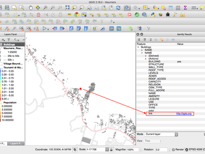
Diese Funktion wurde entwickelt von Sandro Mani (Sourcepole)
Feature: Mausrad über Farbdialog-Schieberegler
In QGIS 2.18 können Sie nun mit dem Mausrad über einen beliebigen Schieberegler im Farbauswahldialog navigieren, um den Wert um kleine Beträge zu erhöhen. Dies ist ein praktisches Tastenkürzel für kleine Veränderungen von Farbkomponenten.
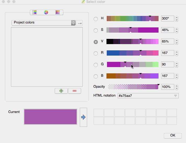
Diese Funktion wurde entwickelt von Nyall Dawson (North Road)
Diese Funktion wurde entwickelt von Nyall Dawson (North Road)
Feature: Fügen Sie benutzerdefinierte Farbschemen zum Farbschaltfläche-Aufklappmenü hinzu
Mit QGIS 2.18 können Benutzer festlegen, ob im den Farbschaltfläche-Aufklappmenü ein von Ihnen erstelltes Farbschema angezeigt werden soll. Diese Einstellung wird über den Farbauswahl-Dialog auf der Registerkarte Listen gesteuert. Fügen Sie einfach ein neues Farbschema hinzu, und kreuzen Sie dann im Schema-Menü die neue Option „in Schaltfläche anzeigen“ an. Es ist ein praktisches Tastenkürzel, wenn Sie Gruppen von häufig verwendeten Paletten haben und möchten, dass sie sofort über das Farbmenü verfügbar sind.
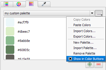
Diese Funktion wurde entwickelt von North Road
Diese Funktion wurde entwickelt von Nyall Dawson (North Road)
Symbologie
Feature: Die Farbauswahl ist jetzt im Layer-Stil-Bedienfeld eingebettet
Wenn Sie in QGIS 2.18 auf eine Farbtaste innerhalb des Layer-Stil-Bedienfelds klicken, wird das Dialogfeld „Farbauswahl“ innerhalb dessen und nicht mehr als separates Dialogfeld geöffnet. Dies ermöglicht eine interaktive Farbveränderung mit sofortiger Vorschau des Ergebnisses.
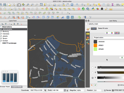
Diese Funktion wurde entwickelt von North Road
Diese Funktion wurde entwickelt von Nyall Dawson (North Road)
Beschriftung
Feature: Substitution list support for labeling
Adds the ability to specify a list of text substitutes to make which apply to label text. Eg abbrevating street types.
Users can export and import lists of substitutes to make reuse and sharing easier.
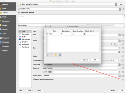
Diese Funktion wurde entwickelt von North Road
Diese Funktion wurde entwickelt von Nyall Dawson (North Road)
Feature: Verbesserter Algorithmus für die Platzierung von Linienbeschriftung
The parallel labeling mode for line layers has been greatly improved, with a new algorithm which avoids placing labels over jagged parts of the feature geometries.
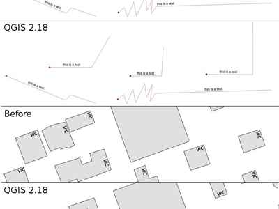
Diese Funktion wurde von Andreas Neumann finanziert
Diese Funktion wurde entwickelt von Nyall Dawson (North Road)
Feature: Label polygons using curved labels along perimeter
This adds a new mode for labeling polygons where the perimeter of the polygon is labeled using curved labeling.
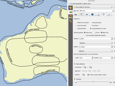
Diese Funktion wurde entwickelt von North Road
Diese Funktion wurde entwickelt von Nyall Dawson (North Road)
Darstellung
Feature: Preview of raster tiles (WMTS and XYZ layers)
In previous versions of QGIS, users had to wait until download of all tiles of a layer has finished in order to view the resulting map. This has now been fixed and the tiles show up in map canvas immediately as they get downloaded, improving the user experience by greatly lowering the time until something is shown. Moreover, previously downloaded tiles from lower or higher resolutions may be used for the preview functionality in the areas where the tiles with correct resolution have not been downloaded yet.
This feature was funded by Land Information New Zealand
This feature was developed by Martin Dobias (Lutra Consulting)
Feature: Cancellable rendering of rasters (WMS, WMTS, WCS and XYZ layers)
This enhancement improves user experience when working with raster layers coming from remote servers. Previously one would need to wait until downloads are fully complete in order to be able to zoom or pan the map again, because the user interface would stay frozen in the meanwhile. This is now fixed by the fact that the rendering of raster layers can be cancelled any time.
This feature was funded by Land Information New Zealand
This feature was developed by Martin Dobias (Lutra Consulting)
Data Management
Feature: Add flag to only copy selected features
The offline editing plugins is a default plugin that ships with QGIS and allows you to offline a remote dataset (e.g. from a database), edit it in the field, and then resynchonise it when you get back to your office. This extends the offline editing possibilities to only work on subset of large layers.
This feature was funded by DB Fahrwegdienste GmbH
This feature was developed by Matthias Kuhn (OPENGIS.ch)
Forms and Widgets
Feature: Allow controlling labels for individual edit widgets
Allow controlling labels for individual edit widgets in a form. In the drag and drop designer, a double click on an item will allow controlling if the label should be shown for each item individually.
In addition it is possible to configure if the link/unlink buttons are shown in relation reference widget, which is useful to hide in 1:n relations where a child can’t exist without its parents.
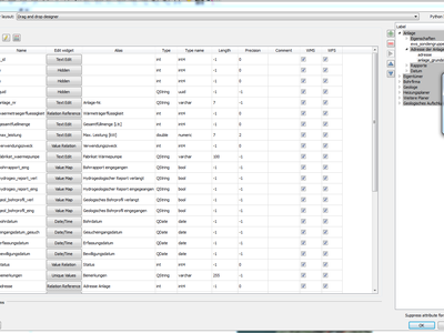
This feature was funded by Kanton Zug, GIS-Fachstelle
This feature was developed by Matthias Kuhn (OPENGIS.ch)
Feature: Conditional visibility for tabs and group boxes
This adds a new configuration option to conditionally show or hide tabs and groupboxes in drag and drop designer forms.
Configuration is done via a double click in the designer tree in the fields configuration interface.
An expression can be entered to control the visibility. The expression will be re-evaluated everytime values in the form change and the tab or groupbox shown/hidden accordingly.
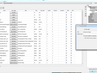
This feature was developed by Matthias Kuhn (OPENGIS.ch)
Feature: Client side default field values
Allows an expression to be set for a vector layer field which is used to evaluate a default value for this field. Default value expressions can utilise properties of the feature which exist at the time of calling, such as digitized geometries. Expression variables can also be used in default value expressions, making it easy to eg insert a user’s name, the current datetime, project path, etc.
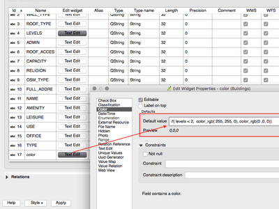
This feature was funded by DB Fahrwegdienste GmbH
Diese Funktion wurde entwickelt von Nyall Dawson (North Road)
Druckzusammenstellung
Feature: True North Arrows
QGIS 2.18 adds support for orienting north arrows in the composer to True North. Previously all arrows were aligned to grid north, which is unsuitable for polar regions or non-north up projections (such as some South African projection systems). Now, you can choose to orient arrows to either grid north or true north. There’s also an optional offset angle, which can be used to specify a grid convergence to make your arrows orient to magnetic north!
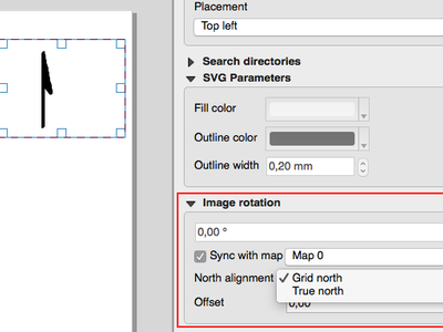
This feature was funded by Norwegian Polar Institute’s Quantarctica project
Diese Funktion wurde entwickelt von Nyall Dawson (North Road)
Verarbeitung
Feature: Point on surface algorithm
This new algorithm is similar to the centroids algorithm, but where a centroid may fall outside its corresponding feature the ‚Point on surface‘ algorithm is guaranteed to create a point which is inside the corresponding polygon feature (or touching the corresponding line feature for line layers).
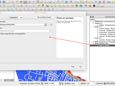
Diese Funktion wurde entwickelt von North Road
Diese Funktion wurde entwickelt von Nyall Dawson (North Road)
Feature: Processing dissolve algorithm accepts multiple fields
The dissolve algorithm now allows you to dissolve based on more than one field value. In previous QGIS versions a dissolve could only group features by a single field value.
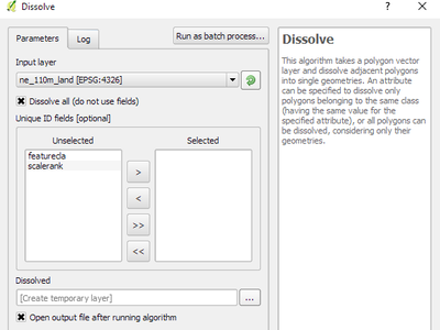
Diese Funktion wurde entwickelt von North Road
Diese Funktion wurde entwickelt von Nyall Dawson (North Road)
Feature: Optimised processing clip algorithm
The processing clip algorithm has been optimised for common use scenarios, resulting in dramatic speedups for clipping operations. For example:
Clipping a roads layer with 1 million lines against 2 polygons
Clipping a 5 million point address layer against 2 polygons
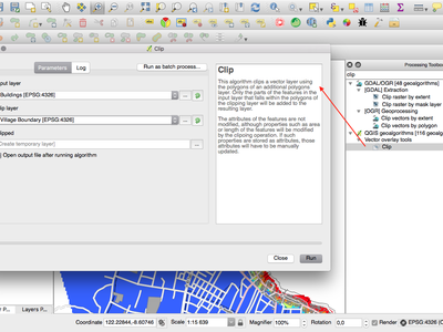
Diese Funktion wurde entwickelt von North Road
Diese Funktion wurde entwickelt von Nyall Dawson (North Road)
Feature: Bounding boxes algorithm
This new algorithm calculates the bounding box (envelope) of each feature in the input layer.
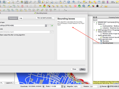
Diese Funktion wurde entwickelt von North Road
Diese Funktion wurde entwickelt von Nyall Dawson (North Road)
Feature: Merge connected lines algorithm
This algorithm joins all the connected parts of MultiLineString geometries into single LineString geometries. If any parts of the input MultiLineString geometries are not connected, the resultant geometry will be a MultiLineString containing any lines which could be merged and any non-connected line parts.
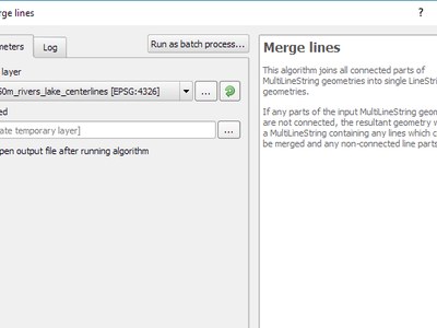
Diese Funktion wurde entwickelt von North Road
Diese Funktion wurde entwickelt von Nyall Dawson (North Road)
Feature: Geometry boundary algorithm
This new algorithm returns the closure of the combinatorial boundary of the input geometries (ie the topological boundary of the geometry). For instance, a polygon geometry will have a boundary consisting of the linestrings for each ring in the polygon, and a line geometry will have a boundary consisting of the start and end points of the line. This algorithm is only valid for polygon or line layers.
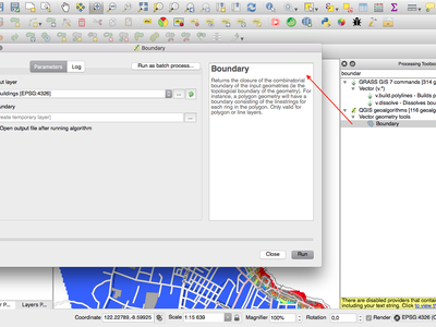
Diese Funktion wurde entwickelt von North Road
Diese Funktion wurde entwickelt von Nyall Dawson (North Road)
Datenanbieter
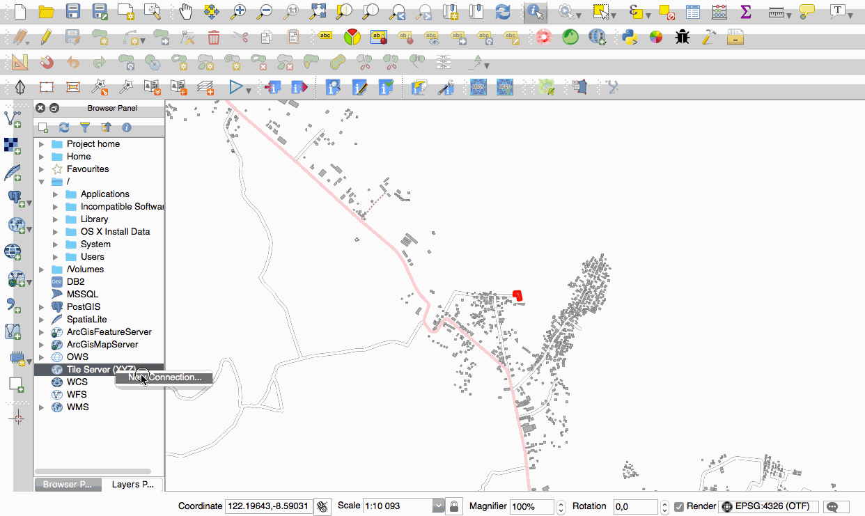
Feature: Native support of XYZ tile layers
Raster tiles in XYZ format are now natively supported within WMS data providers, allowing users to display basemaps from other sources without requiring third-party plugins like QuickMapServices or OpenLayers anymore.
To add connections to XYZ layers, just open browser dock widget, look for item called „Tile Server (XYZ)“ and right click it to get a popup menu with „New connection“ action. You will be asked for URL, in which {x}, {y}, {z} will be replaced by the actual tile numbers according to the current map view. For example, to add OpenStreetMap base map, one may use this URL:
http://c.tile.openstreetmap.org/{z}/{x}/{y}.png
The data provider also supports encoding of XYZ tile numbers into „quadkeys“ used by Bing. Simply use {q} instead of {x}, {y} and {z} in the URL.
This feature was funded by Lutra Consulting
This feature was developed by Martin Dobias (Lutra Consulting)
QGIS Server
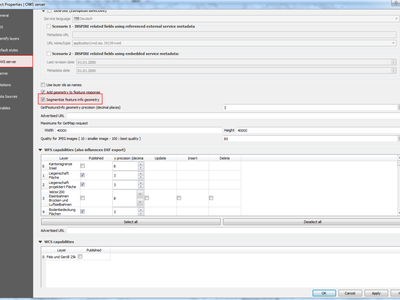
Feature: Possibility to segmentize feature info geometry in server
Necessary for geometries that contain curves (CircularArc, CompoundCurve, CurvePolygon), but the web client (e.g. QGIS Web Client) can’t handle the display of these geometry types.
This feature can be enabled in the „OWS server“ tab in the „Project Properties“ dialogue.
Diese Funktion wurde von Andreas Neumann finanziert
This feature was developed by Marco Hugentobler (Sourcepole)
Erweiterungen
Feature: DB Manager: Add the ability to update SQL Layer
With this feature the user can update the layer datasource if it’s based on an SQL request.
This feature was funded by Ifremer
This feature was developed by 3Liz
Programmability
Feature: Expose GEOS linear referencing function to QgsGeometry
A new function QgsGeometry::lineLocatePoint() has been added for retrieving the distance along a linestring to the nearest position on the linestring to a given point.
Diese Funktion wurde entwickelt von North Road
Diese Funktion wurde entwickelt von Nyall Dawson (North Road)
Feature: New PyQGIS classes in 2.18
New core classes
QgsAnnotation - an interface for annotation items which are drawn over a map
QgsFeedback - a base class for feedback objects to be used for cancellation of something running in a worker thread
QgsOptionalExpression - an expression with an additional enabled flag
New GUI classes, Reusable widgets
QgsExpressionLineEdit - includes a line edit for entering expressions together with a button to open the expression creation dialog. This widget is designed for use in contexts where no layer fields are available for use in an expression and space is constrained.
QgsTabWidget - similar to QTabWidget but with additional methods to temporarily hide/show tabs
Feature: New expression functions
QGIS 2.18 adds several new expression functions, including functions for angle/distance interpolation.
line_merge: merges a MultiLineString geometry into connected LineStringsboundary: returns a geometry’s topological boundary, ie for polygons this is a MultiLineString representing the polygon’s ringsangle_at_vertex: returns the average (bisector) angle to a geometry at a specified vertex indexdistance_to_vertex: returns distance along geometry to a specified vertex indexline_interpolate_angle: calculates the angle parallel to a geometry at the specified distance along the geometryline_interpolate_point: returns a point on line at distanceline_locate_point: returns distance along line to nearest line location closest to specified point
Diese Funktion wurde von Andreas Neumann finanziert
Diese Funktion wurde entwickelt von Nyall Dawson (North Road)