QgsRasterLayer Class Reference
[QGIS core library]
This class provides qgis with the ability to render raster datasets onto the mapcanvas.
More...
#include <qgsrasterlayer.h>
Public Types | |
| enum | ColorShadingAlgorithm { UndefinedShader, PseudoColorShader, FreakOutShader, ColorRampShader, UserDefinedShader } |
| This enumerator describes the types of shading that can be used. More... | |
| enum | DrawingStyle { UndefinedDrawingStyle, SingleBandGray, SingleBandPseudoColor, PalettedColor, PalettedSingleBandGray, PalettedSingleBandPseudoColor, PalettedMultiBandColor, MultiBandSingleGandGray, MultiBandSingleBandGray = MultiBandSingleGandGray, MultiBandSingleBandPseudoColor, MultiBandColor } |
| This enumerator describes the different kinds of drawing we can do. More... | |
| enum | LayerType { GrayOrUndefined, Palette, Multiband } |
| This enumerator describes the type of raster layer. More... | |
| typedef QList < QgsContrastEnhancement > | ContrastEnhancementList |
| A list containing on ContrastEnhancement object per raster band in this raster layer. | |
| typedef QList< QgsRasterPyramid > | RasterPyramidList |
| A list containing one RasterPyramid struct per raster band in this raster layer. | |
| typedef QList< QgsRasterBandStats > | RasterStatsList |
| A list containing one RasterBandStats struct per raster band in this raster layer. | |
Public Slots | |
| QString | buildPyramids (const RasterPyramidList &, const QString &theResamplingMethod="NEAREST", bool theTryInternalFlag=false) |
| Create GDAL pyramid overviews. | |
| void | populateHistogram (int theBandNoInt, int theBinCountInt=256, bool theIgnoreOutOfRangeFlag=true, bool theThoroughBandScanFlag=false) |
| Populate the histogram vector for a given band. | |
| void | showStatusMessage (const QString &theMessage) |
| void | updateProgress (int, int) |
| Propagate progress updates from GDAL up to the parent app. | |
Signals | |
| void | progressUpdate (int theValue) |
| Signal for notifying listeners of long running processes. | |
Public Member Functions | |
| QgsRasterLayer (const QString &path=QString::null, const QString &baseName=QString::null, bool loadDefaultStyleFlag=true) | |
| This is the constructor for the RasterLayer class. | |
| QgsRasterLayer (int dummy, const QString &baseName=QString(), const QString &path=QString(), const QString &providerLib=QString(), const QStringList &layers=QStringList(), const QStringList &styles=QStringList(), const QString &format=QString(), const QString &crs=QString()) | |
| [ data provider interface ] Constructor in provider mode | |
| ~QgsRasterLayer () | |
| The destructor. | |
| QString | blueBandName () const |
| Accessor for blue band name mapping. | |
| QgsRasterLayer::ColorShadingAlgorithm | colorShadingAlgorithm () const |
| Accessor for color shader algorithm. | |
| QgsContrastEnhancement::ContrastEnhancementAlgorithm | contrastEnhancementAlgorithm () |
| Accessor for contrast enhancement algorithm. | |
| QString | contrastEnhancementAlgorithmAsString () const |
| Returns contrast enhancement algorithm as a string. | |
| DrawingStyle | drawingStyle () |
| Accessor for drawing style. | |
| QString | grayBandName () const |
| Accessor for gray band name mapping. | |
| QString | greenBandName () const |
| Accessor for green band name mapping. | |
| bool | hasPyramids () |
| Accessor for mHasPyramids (READ ONLY). | |
| bool | hasUserDefinedGrayMinimumMaximum () const |
| Accessor for mUserDefinedGrayMinimumMaximum. | |
| bool | hasUserDefinedRGBMinimumMaximum () const |
| Accessor for mUserDefinedRGBMinimumMaximum. | |
| int | height () |
| Accessor that returns the height of the (unclipped) raster. | |
| bool | invertHistogram () const |
| Accessor to find out whether the histogram should be inverted. | |
| bool | isNoDataValueValid () const |
| Is the NoDataValue Valid. | |
| bool | isGrayMinimumMaximumEstimated () const |
| Accessor for mGrayMinimumMaximumEstimated. | |
| bool | isRGBMinimumMaximumEstimated () const |
| Accessor for mRGBMinimumMaximumEstimated. | |
| double | noDataValue (bool *isValid=0) |
| Accessor that returns the NO_DATA entry for this raster. | |
| QgsRasterTransparency * | rasterTransparency () |
| Returns a pointer to the transparency object. | |
| QgsRasterShader * | rasterShader () |
| Accessor for raster shader. | |
| LayerType | rasterType () |
| Accessor for raster layer type (which is a read only property). | |
| QString | redBandName () const |
| Accessor for red band name (allows alternate mappings e.g. | |
| void | setDataProvider (const QString &provider, const QStringList &layers, const QStringList &styles, const QString &format, const QString &crs) |
| [ data provider interface ] Set the data provider | |
| void | setDrawingStyle (const DrawingStyle &theDrawingStyle) |
| Mutator for drawing style. | |
| void | setGrayMinimumMaximumEstimated (bool theBool) |
| Mutator for mGrayMinimumMaximumEstimated. | |
| void | setInvertHistogram (bool theFlag) |
| Mutator to alter the state of the invert histogram flag. | |
| void | setRGBMinimumMaximumEstimated (bool theBool) |
| Mutator for mRGBMinimumMaximumEstimated. | |
| void | setStandardDeviations (double theStandardDeviations) |
| Mutator to alter the number of standard deviations that should be plotted. | |
| void | setUserDefinedGrayMinimumMaximum (bool theBool) |
| Mutator for mUserDefinedGrayMinimumMaximum. | |
| void | setUserDefinedRGBMinimumMaximum (bool theBool) |
| Mutator for mUserDefinedRGBMinimumMaximum. | |
| double | standardDeviations () const |
| Accessor to find out how many standard deviations are being plotted. | |
| QString | transparentBandName () const |
| Accessor for transparent band name mapping. | |
| bool | usesProvider () |
| [ data provider interface ] Does this layer use a provider for setting/retrieving data? | |
| int | width () |
| Accessor that returns the width of the (unclipped) raster. | |
| unsigned int | bandCount () |
| Get the number of bands in this layer. | |
| const QString | bandName (int theBandNoInt) |
| Get the name of a band given its number. | |
| int | bandNumber (const QString &theBandName) |
| Get the number of a band given its name. | |
| const QgsRasterBandStats | bandStatistics (int) |
| Get RasterBandStats for a band given its number (read only). | |
| const QgsRasterBandStats | bandStatistics (const QString &) |
| Get RasterBandStats for a band given its name (read only). | |
| RasterPyramidList | buildPyramidList () |
| Accessor for ths raster layers pyramid list. | |
| QString | colorShadingAlgorithmAsString () const |
| Accessor for color shader algorithm. | |
| void | computeMinimumMaximumEstimates (int theBand, double *theMinMax) |
| Wrapper for GDALComputeRasterMinMax with the estimate option. | |
| void | computeMinimumMaximumEstimates (QString theBand, double *theMinMax) |
| Wrapper for GDALComputeRasterMinMax with the estimate option. | |
| void | computeMinimumMaximumEstimates (int theBand, double &theMin, double &theMax) |
| Wrapper for GDALComputeRasterMinMax with the estimate option. | |
| void | computeMinimumMaximumFromLastExtent (int theBand, double *theMinMax) |
| Compute the actual minimum maximum pixel values based on the current (last) display extent. | |
| void | computeMinimumMaximumFromLastExtent (QString theBand, double *theMinMax) |
| Compute the actual minimum maximum pixel values based on the current (last) display extent. | |
| void | computeMinimumMaximumFromLastExtent (int theBand, double &theMin, double &theMax) |
| Compute the actual minimum maximum pixel values based on the current (last) display extent. | |
| QgsContrastEnhancement * | contrastEnhancement (unsigned int theBand) |
| Get a pointer to the contrast enhancement for the selected band. | |
| bool | copySymbologySettings (const QgsMapLayer &theOther) |
| Copies the symbology settings from another layer. | |
| QList < QgsColorRampShader::ColorRampItem > * | colorTable (int theBandNoInt) |
| Get a pointer to the color table. | |
| QgsRasterDataProvider * | dataProvider () |
| Returns the data provider. | |
| const QgsRasterDataProvider * | dataProvider () const |
| Returns the data provider in a const-correct manner. | |
| virtual void | reload () |
| Synchronises with changes in the datasource. | |
| bool | draw (QgsRenderContext &rendererContext) |
| This is called when the view on the raster layer needs to be redrawn. | |
| void | draw (QPainter *theQPainter, QgsRasterViewPort *myRasterViewPort, const QgsMapToPixel *theQgsMapToPixel=0) |
| This is an overloaded version of the draw() function that is called by both draw() and thumbnailAsPixmap. | |
| QString | drawingStyleAsString () const |
| Returns a string representation of drawing style. | |
| bool | hasCompatibleSymbology (const QgsMapLayer &theOther) const |
| Checks if symbology is the same as another layers. | |
| bool | hasStatistics (int theBandNoInt) |
| Check whether a given band number has stats associated with it. | |
| bool | identify (const QgsPoint &point, QMap< QString, QString > &results) |
| Identify raster value(s) found on the point position. | |
| QString | identifyAsText (const QgsPoint &point) |
| Identify arbitrary details from the WMS server found on the point position. | |
| QString | identifyAsHtml (const QgsPoint &point) |
| Identify arbitrary details from the WMS server found on the point position. | |
| bool | isEditable () const |
| Currently returns always false. | |
| QString | lastError () |
| [ data provider interface ] If an operation returns 0 (e.g. | |
| QString | lastErrorTitle () |
| [ data provider interface ] If an operation returns 0 (e.g. | |
| QPixmap | legendAsPixmap () |
| Get a legend image for this layer. | |
| QPixmap | legendAsPixmap (bool) |
| Overloaded version of above function that can print layer name onto legend. | |
| QPixmap | legendAsPixmap (int theLabelCount) |
| Use this method when you want an annotated legend suitable for print output etc. | |
| double | maximumValue (unsigned int theBand) |
| Accessor for maximum value user for contrast enhancement. | |
| double | maximumValue (QString theBand) |
| Accessor for maximum value user for contrast enhancement. | |
| QString | metadata () |
| Obtain GDAL Metadata for this layer. | |
| double | minimumValue (unsigned int theBand) |
| Accessor for minimum value user for contrast enhancement. | |
| double | minimumValue (QString theBand) |
| Accessor for minimum value user for contrast enhancement. | |
| QPixmap | paletteAsPixmap (int theBand=1) |
| Get an 100x100 pixmap of the color palette. | |
| QString | providerKey () |
| [ data provider interface ] Which provider is being used for this Raster Layer? | |
| double | rasterUnitsPerPixel () |
| Returns the number of raster units per each raster pixel. | |
| bool | readColorTable (int theBandNumber, QList< QgsColorRampShader::ColorRampItem > *theList) |
| Read color table from GDAL raster band. | |
| void | resetNoDataValue () |
| Simple reset function that set the noDataValue back to the value stored in the first raster band. | |
| void | setBlueBandName (const QString &theBandName) |
| Mutator for blue band name mapping. | |
| void | setColorShadingAlgorithm (QgsRasterLayer::ColorShadingAlgorithm theShaderAlgorithm) |
| Mutator for color shader algorithm. | |
| void | setColorShadingAlgorithm (QString theShaderAlgorithm) |
| Mutator for color shader algorithm. | |
| void | setContrastEnhancementAlgorithm (QgsContrastEnhancement::ContrastEnhancementAlgorithm theAlgorithm, bool theGenerateLookupTableFlag=true) |
| Mutator for contrast enhancement algorithm. | |
| void | setContrastEnhancementAlgorithm (QString theAlgorithm, bool theGenerateLookupTableFlag=true) |
| Mutator for contrast enhancement algorithm. | |
| void | setContrastEnhancementFunction (QgsContrastEnhancementFunction *theFunction) |
| Mutator for contrast enhancement function. | |
| void | setDrawingStyle (const QString &theDrawingStyleQString) |
| Overloaded version of the above function for convenience when restoring from xml. | |
| void | setGrayBandName (const QString &theBandName) |
| Mutator for gray band name mapping. | |
| void | setGreenBandName (const QString &theBandName) |
| Mutator for green band name mapping. | |
| void | setMaximumValue (unsigned int theBand, double theValue, bool theGenerateLookupTableFlag=true) |
| Mutator for setting the maximum value for contrast enhancement. | |
| void | setMaximumValue (QString theBand, double theValue, bool theGenerateLookupTableFlag=true) |
| Mutator for setting the maximum value for contrast enhancement. | |
| void | setMinimumMaximumUsingLastExtent () |
| Sets the minimum and maximum values for the band(s) currently being displayed using the only pixel values from the last/current extent. | |
| void | setMinimumValue (unsigned int theBand, double theValue, bool theGenerateLookupTableFlag=true) |
| Mutator for setting the minimum value for contrast enhancement. | |
| void | setMinimumValue (QString theBand, double theValue, bool theGenerateLookupTableFlag=true) |
| Mutator for setting the minimum value for contrast enhancement. | |
| void | setNoDataValue (double theNoData) |
| Mutator that allows the NO_DATA entry for this raster to be overridden. | |
| void | setRasterShaderFunction (QgsRasterShaderFunction *theFunction) |
| Set the raster shader function to a user defined function. | |
| void | setRedBandName (const QString &theBandName) |
| Mutator for red band name (allows alternate mappings e.g. | |
| void | setTransparentBandName (const QString &theBandName) |
| Mutator for transparent band name mapping. | |
| void | showProgress (int theValue) |
| [ data provider interface ] A wrapper function to emit a progress update signal | |
| QStringList | subLayers () const |
| Returns the sublayers of this layer - Useful for providers that manage their own layers, such as WMS. | |
| void | thumbnailAsPixmap (QPixmap *theQPixmap) |
| Draws a thumbnail of the rasterlayer into the supplied pixmap pointer. | |
| void | thumbnailAsImage (QImage *thepImage) |
| Draws a thumbnail of the rasterlayer into the supplied QImage pointer. | |
| void | triggerRepaint () |
| Emit a signal asking for a repaint. | |
| virtual void | setLayerOrder (const QStringList &layers) |
| Reorders the *previously selected* sublayers of this layer from bottom to top. | |
| virtual void | setSubLayerVisibility (const QString &name, bool vis) |
| Set the visibility of the given sublayer name. | |
Static Public Member Functions | |
| static void | buildSupportedRasterFileFilter (QString &fileFilters) |
| Builds the list of file filter strings to later be used by QgisApp::addRasterLayer(). | |
| static bool | isValidRasterFileName (const QString &theFileNameQString, QString &retError) |
| This helper checks to see whether the file name appears to be a valid raster file name. | |
| static bool | isValidRasterFileName (const QString &theFileNameQString) |
| static QStringList | subLayers (GDALDatasetH dataset) |
| static QDateTime | lastModified (const QString &name) |
| Return time stamp for given file name. | |
| static void | registerGdalDrivers () |
| ensures that GDAL drivers are registered, but only once | |
Protected Member Functions | |
| bool | readSymbology (const QDomNode &node, QString &errorMessage) |
| Read the symbology for the current layer from the Dom node supplied. | |
| bool | readXml (QDomNode &layer_node) |
| Reads layer specific state from project file Dom node. | |
| bool | writeSymbology (QDomNode &, QDomDocument &doc, QString &errorMessage) const |
| Write the symbology for the layer into the docment provided. | |
| bool | writeXml (QDomNode &layer_node, QDomDocument &doc) |
| Write layer specific state to project file Dom node. | |
Private Member Functions | |
| void | drawMultiBandColor (QPainter *theQPainter, QgsRasterViewPort *theRasterViewPort, const QgsMapToPixel *theQgsMapToPixel) |
| Drawing routine for multiband image. | |
| void | drawMultiBandSingleBandGray (QPainter *theQPainter, QgsRasterViewPort *theRasterViewPort, const QgsMapToPixel *theQgsMapToPixel, int theBandNoInt) |
| Drawing routine for multiband image, rendered as a single band image in grayscale. | |
| void | drawMultiBandSingleBandPseudoColor (QPainter *theQPainter, QgsRasterViewPort *theRasterViewPort, const QgsMapToPixel *theQgsMapToPixel, int theBandNoInt) |
| Drawing routine for multiband image, rendered as a single band image in pseudocolor. | |
| void | drawPalettedSingleBandColor (QPainter *theQPainter, QgsRasterViewPort *theRasterViewPort, const QgsMapToPixel *theQgsMapToPixel, int theBandNoInt) |
| Drawing routine for single band with a color map. | |
| void | drawPalettedSingleBandGray (QPainter *theQPainter, QgsRasterViewPort *theRasterViewPort, const QgsMapToPixel *theQgsMapToPixel, int theBandNoInt) |
| Drawing routine for paletted image, rendered as a single band image in grayscale. | |
| void | drawPalettedSingleBandPseudoColor (QPainter *theQPainter, QgsRasterViewPort *theRasterViewPort, const QgsMapToPixel *theQgsMapToPixel, int theBandNoInt) |
| Drawing routine for paletted image, rendered as a single band image in pseudocolor. | |
| void | drawPalettedMultiBandColor (QPainter *theQPainter, QgsRasterViewPort *theRasterViewPort, const QgsMapToPixel *theQgsMapToPixel, int theBandNoInt) |
| Drawing routine for paletted multiband image. | |
| void | drawSingleBandGray (QPainter *theQPainter, QgsRasterViewPort *theRasterViewPort, const QgsMapToPixel *theQgsMapToPixel, int theBandNoInt) |
| Drawing routine for single band grayscale image. | |
| void | drawSingleBandPseudoColor (QPainter *theQPainter, QgsRasterViewPort *theRasterViewPort, const QgsMapToPixel *theQgsMapToPixel, int theBandNoInt) |
| Drawing routine for single band grayscale image, rendered in pseudocolor. | |
| void | closeDataset () |
| Close data set and release related data. | |
| QString | generateBandName (int) |
| helper function to create zero padded band names | |
| bool | hasBand (const QString &theBandName) |
| Find out whether a given band exists. | |
| void | paintImageToCanvas (QPainter *theQPainter, QgsRasterViewPort *theRasterViewPort, const QgsMapToPixel *theQgsMapToPixel, QImage *theImage) |
| Places the rendered image onto the canvas. | |
| QString | projectionWkt () |
| Query GDAL to find out the Wkt projection string for this layer. | |
| void * | readData (GDALRasterBandH gdalBand, QgsRasterViewPort *viewPort) |
| Allocate memory and load data to that allocated memory. | |
| bool | readFile (const QString &fileName) |
| Load the given raster file. | |
| double | readValue (void *data, GDALDataType type, int index) |
| Read a raster value given position from memory block created by readData(). | |
| bool | update () |
| Update the layer if it is outdated. | |
| QString | validateBandName (const QString &theBandName) |
| Verify and transform band name for internal consistency. | |
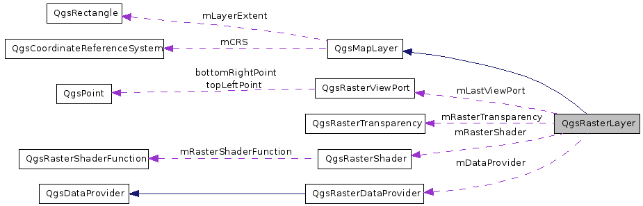
Private Attributes | |
| const QString | QSTRING_NOT_SET |
| Constant defining flag for XML and a constant that signals property not used. | |
| const QString | TRSTRING_NOT_SET |
| int | mBandCount |
| The number of bands in the dataset. | |
| QString | mBlueBandName |
| The band to be associated with the color blue - usually 3. | |
| ColorShadingAlgorithm | mColorShadingAlgorithm |
| The raster shading algorithm being used. | |
| QgsContrastEnhancement::ContrastEnhancementAlgorithm | mContrastEnhancementAlgorithm |
| The contrast enhancement algorithm being used. | |
| ContrastEnhancementList | mContrastEnhancementList |
| List containing the contrast enhancements for each band. | |
| double | mStandardDeviations |
| Number of stddev to plot (0) to ignore. | |
| QgsRasterDataProvider * | mDataProvider |
| [ data provider interface ] Pointer to data provider derived from the abstract base class QgsDataProvider | |
| DrawingStyle | mDrawingStyle |
| bool | mEditable |
| [ data provider interface ] Flag indicating whether the layer is in editing mode or not | |
| QString | mError |
| [ data provider interface ]The error message associated with the last error | |
| QString | mErrorCaption |
| [ data provider interface ] The error caption associated with the last error | |
| GDALDatasetH | mGdalBaseDataset |
| Pointer to the gdaldataset. | |
| GDALDatasetH | mGdalDataset |
| Pointer to the gdaldataset (possibly warped vrt). | |
| double | mGeoTransform [6] |
| Values for mapping pixel to world coordinates. | |
| QString | mGrayBandName |
| The band to be associated with the grayscale only output - usually 1. | |
| bool | mGrayMinimumMaximumEstimated |
| Flag to indicate of the min max values are actual or estimates/user defined. | |
| QString | mGreenBandName |
| The band to be associated with the color green - usually 2. | |
| bool | mHasPyramids |
| Whether this raster has overviews / pyramids or not. | |
| int | mWidth |
| Raster width. | |
| int | mHeight |
| Raster height. | |
| bool | mInvertColor |
| Flag indicating whether the color of pixels should be inverted or not. | |
| QDateTime | mLastModified |
| [ data provider interface ] Timestamp, the last modified time of the data source when the layer was created | |
| QgsRasterViewPort | mLastViewPort |
| QLibrary * | mLib |
| [ data provider interface ] pointer for loading the provider library | |
| bool | mModified |
| [ data provider interface ] Flag indicating whether the layer has been modified since the last commit | |
| double | mNoDataValue |
| Cell value representing no data. | |
| QString | mProviderKey |
| [ data provider interface ] Data provider key | |
| RasterPyramidList | mPyramidList |
| This list holds a series of RasterPyramid structs which store information for each potential pyramid level. | |
| QgsRasterShader * | mRasterShader |
| The raster shader for the layer. | |
| RasterStatsList | mRasterStatsList |
| A collection of stats - one for each band in the layer. | |
| QgsRasterTransparency | mRasterTransparency |
| The transparency container. | |
| LayerType | mRasterType |
| QString | mRedBandName |
| The band to be associated with the color red - usually 1. | |
| bool | mRGBMinimumMaximumEstimated |
| Flag to indicate of the min max values are actual or estimates/user defined. | |
| QString | mTransparencyBandName |
| The band to be associated with transparency. | |
| bool | mUserDefinedGrayMinimumMaximum |
| Flag to indicate if the user entered custom min max values. | |
| bool | mUserDefinedRGBMinimumMaximum |
| Flag to indicate if the user entered custom min max values. | |
| bool | mValidNoDataValue |
| Flag indicating if the nodatavalue is valid. | |
Detailed Description
This class provides qgis with the ability to render raster datasets onto the mapcanvas.The qgsrasterlayer class makes use of gdal for data io, and thus supports any gdal supported format. The constructor attempts to infer what type of file (LayerType) is being opened - not in terms of the file format (tif, ascii grid etc.) but rather in terms of whether the image is a GRAYSCALE, PaletteD or Multiband,
Within the three allowable raster layer types, there are 8 permutations of how a layer can actually be rendered. These are defined in the DrawingStyle enum and consist of:
SingleBandGray -> a GRAYSCALE layer drawn as a range of gray colors (0-255) SingleBandPseudoColor -> a GRAYSCALE layer drawn using a pseudocolor algorithm PalettedSingleBandGray -> a PaletteD layer drawn in gray scale (using only one of the color components) PalettedSingleBandPseudoColor -> a PaletteD layer having only one of its color components rendered as psuedo color PalettedMultiBandColor -> a PaletteD image where the bands contains 24bit color info and 8 bits is pulled out per color MultiBandSingleBandGray -> a layer containing 2 or more bands, but using only one band to produce a grayscale image MultiBandSingleBandPseudoColor -> a layer containing 2 or more bands, but using only one band to produce a pseudocolor image MultiBandColor -> a layer containing 2 or more bands, mapped to the three RGBcolors. In the case of a multiband with only two bands, one band will have to be mapped to more than one color
Each of the above mentioned drawing styles is implemented in its own draw* function. Some of the drawing styles listed above require statistics about the layer such as the min / max / mean / stddev etc. statistics for a band can be gathered using the bandStatistics function. Note that statistics gathering is a slow process and every effort should be made to call this function as few times as possible. For this reason, qgsraster has a vector class member to store stats for each band. The constructor initialises this vector on startup, but only populates the band name and number fields.
Note that where bands are of gdal 'undefined' type, their values may exceed the renderable range of 0-255. Because of this a linear scaling histogram enhanceContrast is applied to undefined layers to normalise the data into the 0-255 range.
A qgsrasterlayer band can be referred to either by name or by number (base=1). It should be noted that band names as stored in datafiles may not be unique, and so the rasterlayer class appends the band number in brackets behind each band name.
Sample usage of the QgsRasterLayer class:
     QString myFileNameQString = "/path/to/file";
     QFileInfo myFileInfo(myFileNameQString);
     QString myBaseNameQString = myFileInfo.baseName();
     QgsRasterLayer *myRasterLayer = new QgsRasterLayer(myFileNameQString, myBaseNameQString);
In order to automate redrawing of a raster layer, you should like it to a map canvas like this :
QObject::connect( myRasterLayer, SIGNAL(repaintRequested()), mapCanvas, SLOT(refresh()) );
A raster layer can also export its legend as a pixmap:
QPixmap myQPixmap = myRasterLayer->legendPixmap();
Once a layer has been created you can find out what type of layer it is (GrayOrUndefined, Palette or Multiband):
    if (rasterLayer->rasterType()==QgsRasterLayer::Multiband)
    {
      //do something
    }
    else if (rasterLayer->rasterType()==QgsRasterLayer::Palette)
    {
      //do something
    }
    else // QgsRasterLayer::GrayOrUndefined
    {
      //do something.
    }
You can combine layer type detection with the setDrawingStyle method to override the default drawing style assigned when a layer is loaded:
    if (rasterLayer->rasterType()==QgsRasterLayer::Multiband)
    {
       myRasterLayer->setDrawingStyle(QgsRasterLayer::MultiBandSingleBandPseudoColor);
    }
    else if (rasterLayer->rasterType()==QgsRasterLayer::Palette)
    {
      myRasterLayer->setDrawingStyle(QgsRasterLayer::PalettedSingleBandPseudoColor);
    }
    else // QgsRasterLayer::GrayOrUndefined
    {
      myRasterLayer->setDrawingStyle(QgsRasterLayer::SingleBandPseudoColor);
    }
Raster layers can also have an arbitrary level of transparency defined, and have their color palettes inverted using the setTransparency and setInvertHistogram methods.
Pseudocolor images can have their output adjusted to a given number of standard deviations using the setStandardDeviations method.
The final area of functionality you may be interested in is band mapping. Band mapping allows you to choose arbitrary band -> color mappings and is applicable only to Palette and Multiband rasters, There are four mappings that can be made: red, green, blue and gray. Mappings are non-exclusive. That is a given band can be assigned to no, some or all color mappings. The constructor sets sensible defaults for band mappings but these can be overridden at run time using the setRedBandName, setGreenBandName, setBlueBandName and setGrayBandName methods.
Definition at line 178 of file qgsrasterlayer.h.
Member Typedef Documentation
| typedef QList<QgsContrastEnhancement> QgsRasterLayer::ContrastEnhancementList |
A list containing on ContrastEnhancement object per raster band in this raster layer.
Definition at line 257 of file qgsrasterlayer.h.
| typedef QList<QgsRasterPyramid> QgsRasterLayer::RasterPyramidList |
A list containing one RasterPyramid struct per raster band in this raster layer.
POTENTIAL pyramid layer. This works by dividing the height and width of the raster by an incrementing number. As soon as the result of the division is <=256 we stop allowing RasterPyramid structs to be added to the list. Each time a RasterPyramid is created we will check to see if a pyramid matching these dimensions already exists in the raster layer, and if so mark the exists flag as true
Definition at line 266 of file qgsrasterlayer.h.
| typedef QList<QgsRasterBandStats> QgsRasterLayer::RasterStatsList |
A list containing one RasterBandStats struct per raster band in this raster layer.
Note that while every RasterBandStats element will have the name and number of its associated band populated, any additional stats are calculated on a need to know basis.
Definition at line 271 of file qgsrasterlayer.h.
Member Enumeration Documentation
This enumerator describes the types of shading that can be used.
Definition at line 221 of file qgsrasterlayer.h.
This enumerator describes the different kinds of drawing we can do.
- Enumerator:
Definition at line 231 of file qgsrasterlayer.h.
This enumerator describes the type of raster layer.
Reimplemented from QgsMapLayer.
Definition at line 249 of file qgsrasterlayer.h.
Constructor & Destructor Documentation
| QgsRasterLayer::QgsRasterLayer | ( | const QString & | path = QString::null, |
|
| const QString & | baseName = QString::null, |
|||
| bool | loadDefaultStyleFlag = true | |||
| ) |
This is the constructor for the RasterLayer class.
The main tasks carried out by the constructor are:
-Load the rasters default style (.qml) file if it exists
-Populate the RasterStatsVector with initial values for each band.
-Calculate the layer extents
-Determine whether the layer is gray, paletted or multiband.
-Assign sensible defaults for the red, green, blue and gray bands.
Definition at line 83 of file qgsrasterlayer.cpp.
References QgsRasterViewPort::clippedHeight, QgsRasterViewPort::clippedWidth, QgsRasterViewPort::clippedXMax, QgsRasterViewPort::clippedXMin, QgsRasterViewPort::clippedYMax, QgsRasterViewPort::clippedYMin, QgsRasterViewPort::drawableAreaXDim, QgsRasterViewPort::drawableAreaYDim, GrayOrUndefined, QgsMapLayer::loadDefaultStyle(), mBandCount, mBlueBandName, mColorShadingAlgorithm, mContrastEnhancementAlgorithm, mDrawingStyle, mGdalBaseDataset, mGdalDataset, mGeoTransform, mGrayBandName, mGrayMinimumMaximumEstimated, mGreenBandName, mHasPyramids, mLastViewPort, mNoDataValue, mRasterShader, mRasterType, mRedBandName, mRGBMinimumMaximumEstimated, mTransparencyBandName, mUserDefinedGrayMinimumMaximum, mUserDefinedRGBMinimumMaximum, mValidNoDataValue, QgsContrastEnhancement::NoEnhancement, readFile(), QgsRasterViewPort::rectXOffset, QgsRasterViewPort::rectXOffsetFloat, QgsRasterViewPort::rectYOffset, QgsRasterViewPort::rectYOffsetFloat, QgsMapLayer::setLayerName(), TRSTRING_NOT_SET, UndefinedDrawingStyle, and UndefinedShader.
| QgsRasterLayer::QgsRasterLayer | ( | int | dummy, | |
| const QString & | baseName = QString(), |
|||
| const QString & | path = QString(), |
|||
| const QString & | providerLib = QString(), |
|||
| const QStringList & | layers = QStringList(), |
|||
| const QStringList & | styles = QStringList(), |
|||
| const QString & | format = QString(), |
|||
| const QString & | crs = QString() | |||
| ) |
[ data provider interface ] Constructor in provider mode
- Todo:
- Rename into a general constructor when the old raster interface is retired parameter dummy is just there to distinguish this function signature from the old non-provider one.
Definition at line 178 of file qgsrasterlayer.cpp.
References mBandCount, mDataProvider, mGeoTransform, mRasterShader, QgsDebugMsg, setDataProvider(), showStatusMessage(), and QgsMapLayer::statusChanged().
| QgsRasterLayer::~QgsRasterLayer | ( | ) |
The destructor.
Definition at line 243 of file qgsrasterlayer.cpp.
References mGdalBaseDataset, mGdalDataset, mProviderKey, and mRasterShader.
Member Function Documentation
| void QgsRasterLayer::buildSupportedRasterFileFilter | ( | QString & | theFileFiltersString | ) | [static] |
Builds the list of file filter strings to later be used by QgisApp::addRasterLayer().
We query GDAL for a list of supported raster formats; we then build a list of file filter strings from that list. We return a string that contains this list that is suitable for use in a QFileDialog::getOpenFileNames() call.
Definition at line 280 of file qgsrasterlayer.cpp.
References QgsDebugMsg, registerGdalDrivers(), and QgsLogger::warning().
| bool QgsRasterLayer::isValidRasterFileName | ( | const QString & | theFileNameQString, | |
| QString & | retError | |||
| ) | [static] |
This helper checks to see whether the file name appears to be a valid raster file name.
This helper checks to see whether the file name appears to be a valid raster file name.
If the file name looks like it could be valid, but some sort of error occurs in processing the file, the error is returned in retError.
Definition at line 452 of file qgsrasterlayer.cpp.
References registerGdalDrivers(), subLayers(), and TO8F.
Referenced by isValidRasterFileName().
| bool QgsRasterLayer::isValidRasterFileName | ( | const QString & | theFileNameQString | ) | [static] |
| QStringList QgsRasterLayer::subLayers | ( | GDALDatasetH | dataset | ) | [static] |
Definition at line 3619 of file qgsrasterlayer.cpp.
References metadata(), QgsDebugMsg, and subLayers().
| QDateTime QgsRasterLayer::lastModified | ( | const QString & | name | ) | [static] |
Return time stamp for given file name.
Definition at line 492 of file qgsrasterlayer.cpp.
References QgsDebugMsg.
Referenced by readFile(), and update().
| void QgsRasterLayer::registerGdalDrivers | ( | ) | [static] |
ensures that GDAL drivers are registered, but only once
Definition at line 511 of file qgsrasterlayer.cpp.
Referenced by buildSupportedRasterFileFilter(), isValidRasterFileName(), and readFile().
| QString QgsRasterLayer::blueBandName | ( | ) | const [inline] |
Accessor for blue band name mapping.
Definition at line 306 of file qgsrasterlayer.h.
Referenced by setMinimumMaximumUsingLastExtent(), and writeSymbology().
| QgsRasterLayer::ColorShadingAlgorithm QgsRasterLayer::colorShadingAlgorithm | ( | ) | const [inline] |
Accessor for color shader algorithm.
Definition at line 309 of file qgsrasterlayer.h.
Referenced by writeSymbology().
| QgsContrastEnhancement::ContrastEnhancementAlgorithm QgsRasterLayer::contrastEnhancementAlgorithm | ( | ) | [inline] |
Accessor for contrast enhancement algorithm.
Definition at line 312 of file qgsrasterlayer.h.
Referenced by drawMultiBandColor(), and drawSingleBandGray().
| QString QgsRasterLayer::contrastEnhancementAlgorithmAsString | ( | ) | const |
Returns contrast enhancement algorithm as a string.
Definition at line 1330 of file qgsrasterlayer.cpp.
References QgsContrastEnhancement::ClipToMinimumMaximum, mContrastEnhancementAlgorithm, QgsContrastEnhancement::NoEnhancement, QgsContrastEnhancement::StretchAndClipToMinimumMaximum, QgsContrastEnhancement::StretchToMinimumMaximum, and QgsContrastEnhancement::UserDefinedEnhancement.
Referenced by writeSymbology().
| DrawingStyle QgsRasterLayer::drawingStyle | ( | ) | [inline] |
Accessor for drawing style.
Definition at line 318 of file qgsrasterlayer.h.
Referenced by setMinimumMaximumUsingLastExtent().
| QString QgsRasterLayer::grayBandName | ( | ) | const [inline] |
Accessor for gray band name mapping.
Definition at line 321 of file qgsrasterlayer.h.
Referenced by setMinimumMaximumUsingLastExtent(), and writeSymbology().
| QString QgsRasterLayer::greenBandName | ( | ) | const [inline] |
Accessor for green band name mapping.
Definition at line 324 of file qgsrasterlayer.h.
Referenced by setMinimumMaximumUsingLastExtent(), and writeSymbology().
| bool QgsRasterLayer::hasPyramids | ( | ) | [inline] |
| bool QgsRasterLayer::hasUserDefinedGrayMinimumMaximum | ( | ) | const [inline] |
Accessor for mUserDefinedGrayMinimumMaximum.
Definition at line 330 of file qgsrasterlayer.h.
Referenced by writeSymbology().
| bool QgsRasterLayer::hasUserDefinedRGBMinimumMaximum | ( | ) | const [inline] |
Accessor for mUserDefinedRGBMinimumMaximum.
Definition at line 333 of file qgsrasterlayer.h.
Referenced by writeSymbology().
| int QgsRasterLayer::height | ( | ) | [inline] |
Accessor that returns the height of the (unclipped) raster.
Definition at line 336 of file qgsrasterlayer.h.
| bool QgsRasterLayer::invertHistogram | ( | ) | const [inline] |
Accessor to find out whether the histogram should be inverted.
Definition at line 339 of file qgsrasterlayer.h.
Referenced by writeSymbology().
| bool QgsRasterLayer::isNoDataValueValid | ( | ) | const [inline] |
| bool QgsRasterLayer::isGrayMinimumMaximumEstimated | ( | ) | const [inline] |
Accessor for mGrayMinimumMaximumEstimated.
Definition at line 345 of file qgsrasterlayer.h.
Referenced by writeSymbology().
| bool QgsRasterLayer::isRGBMinimumMaximumEstimated | ( | ) | const [inline] |
Accessor for mRGBMinimumMaximumEstimated.
Definition at line 348 of file qgsrasterlayer.h.
Referenced by writeSymbology().
| double QgsRasterLayer::noDataValue | ( | bool * | isValid = 0 |
) | [inline] |
Accessor that returns the NO_DATA entry for this raster.
Definition at line 351 of file qgsrasterlayer.h.
| QgsRasterTransparency* QgsRasterLayer::rasterTransparency | ( | ) | [inline] |
| QgsRasterShader* QgsRasterLayer::rasterShader | ( | ) | [inline] |
| LayerType QgsRasterLayer::rasterType | ( | ) | [inline] |
Accessor for raster layer type (which is a read only property).
Definition at line 360 of file qgsrasterlayer.h.
Referenced by setMinimumMaximumUsingLastExtent().
| QString QgsRasterLayer::redBandName | ( | ) | const [inline] |
Accessor for red band name (allows alternate mappings e.g.
map blue as red color)
Definition at line 363 of file qgsrasterlayer.h.
Referenced by setMinimumMaximumUsingLastExtent(), and writeSymbology().
| void QgsRasterLayer::setDataProvider | ( | const QString & | provider, | |
| const QStringList & | layers, | |||
| const QStringList & | styles, | |||
| const QString & | format, | |||
| const QString & | crs | |||
| ) |
[ data provider interface ] Set the data provider
Copied from QgsVectorLayer::setDataProvider TODO: Make it work in the raster environment.
Definition at line 3194 of file qgsrasterlayer.cpp.
References QgsRasterDataProvider::addLayers(), cast_to_fptr(), QgsCoordinateReferenceSystem::createFromOgcWmsCrs(), QgsDataProvider::crs(), QgsDataProvider::extent(), QgsProviderRegistry::instance(), QgsDataProvider::isValid(), QgsProviderRegistry::library(), QgsMapLayer::mCRS, mDataProvider, QgsMapLayer::mDataSource, mDrawingStyle, QgsMapLayer::mLayerExtent, mLib, mProviderKey, MultiBandColor, QgsMapLayer::mValid, QgsMapLayer::name(), QgsDebugMsg, QgsRasterDataProvider::setImageCrs(), QgsRasterDataProvider::setImageEncoding(), QgsRectangle::setXMaximum(), QgsRectangle::setXMinimum(), QgsRectangle::setYMaximum(), QgsRectangle::setYMinimum(), QgsRectangle::toString(), QgsLogger::warning(), QgsRectangle::xMaximum(), QgsRectangle::xMinimum(), QgsRectangle::yMaximum(), and QgsRectangle::yMinimum().
Referenced by QgsRasterLayer(), and readXml().
| void QgsRasterLayer::setDrawingStyle | ( | const DrawingStyle & | theDrawingStyle | ) | [inline] |
Mutator for drawing style.
Definition at line 373 of file qgsrasterlayer.h.
Referenced by readSymbology().
| void QgsRasterLayer::setGrayMinimumMaximumEstimated | ( | bool | theBool | ) | [inline] |
Mutator for mGrayMinimumMaximumEstimated.
Definition at line 376 of file qgsrasterlayer.h.
Referenced by readSymbology().
| void QgsRasterLayer::setInvertHistogram | ( | bool | theFlag | ) | [inline] |
Mutator to alter the state of the invert histogram flag.
Definition at line 379 of file qgsrasterlayer.h.
Referenced by readSymbology().
| void QgsRasterLayer::setRGBMinimumMaximumEstimated | ( | bool | theBool | ) | [inline] |
Mutator for mRGBMinimumMaximumEstimated.
Definition at line 382 of file qgsrasterlayer.h.
Referenced by readSymbology().
| void QgsRasterLayer::setStandardDeviations | ( | double | theStandardDeviations | ) | [inline] |
Mutator to alter the number of standard deviations that should be plotted.
Definition at line 385 of file qgsrasterlayer.h.
Referenced by readSymbology().
| void QgsRasterLayer::setUserDefinedGrayMinimumMaximum | ( | bool | theBool | ) | [inline] |
Mutator for mUserDefinedGrayMinimumMaximum.
Definition at line 388 of file qgsrasterlayer.h.
Referenced by readSymbology(), and setMinimumMaximumUsingLastExtent().
| void QgsRasterLayer::setUserDefinedRGBMinimumMaximum | ( | bool | theBool | ) | [inline] |
Mutator for mUserDefinedRGBMinimumMaximum.
Definition at line 391 of file qgsrasterlayer.h.
Referenced by readSymbology(), and setMinimumMaximumUsingLastExtent().
| double QgsRasterLayer::standardDeviations | ( | ) | const [inline] |
Accessor to find out how many standard deviations are being plotted.
Definition at line 394 of file qgsrasterlayer.h.
Referenced by writeSymbology().
| QString QgsRasterLayer::transparentBandName | ( | ) | const [inline] |
| bool QgsRasterLayer::usesProvider | ( | ) |
[ data provider interface ] Does this layer use a provider for setting/retrieving data?
Definition at line 5596 of file qgsrasterlayer.cpp.
References mProviderKey.
Referenced by update().
| int QgsRasterLayer::width | ( | ) | [inline] |
Accessor that returns the width of the (unclipped) raster.
Definition at line 403 of file qgsrasterlayer.h.
| unsigned int QgsRasterLayer::bandCount | ( | ) |
Get the number of bands in this layer.
Definition at line 628 of file qgsrasterlayer.cpp.
References mBandCount.
Referenced by computeMinimumMaximumEstimates(), computeMinimumMaximumFromLastExtent(), contrastEnhancement(), generateBandName(), maximumValue(), metadata(), minimumValue(), setMaximumValue(), and setMinimumValue().
| const QString QgsRasterLayer::bandName | ( | int | theBandNoInt | ) |
Get the name of a band given its number.
Definition at line 633 of file qgsrasterlayer.cpp.
References mRasterStatsList.
Referenced by metadata(), readFile(), and validateBandName().
| int QgsRasterLayer::bandNumber | ( | const QString & | theBandName | ) |
Get the number of a band given its name.
The name is the rewritten name set up in the constructor, and will not necessarily be the same as the name retrieved directly from gdal! If no matching band is found zero will be returned!
Definition at line 646 of file qgsrasterlayer.cpp.
References QgsRasterBandStats::bandName, QgsRasterBandStats::bandNumber, mRasterStatsList, and QgsDebugMsg.
Referenced by computeMinimumMaximumEstimates(), computeMinimumMaximumFromLastExtent(), draw(), drawMultiBandColor(), maximumValue(), minimumValue(), setMaximumValue(), and setMinimumValue().
| const QgsRasterBandStats QgsRasterLayer::bandStatistics | ( | int | theBandNo | ) |
Get RasterBandStats for a band given its number (read only).
Private method to calculate statistics for a band.
Populates rasterStatsMemArray. Calculates:
- myRasterBandStats.elementCount
- myRasterBandStats.minimumValue
- myRasterBandStats.maximumValue
- myRasterBandStats.sum
- myRasterBandStats.range
- myRasterBandStats.mean
- myRasterBandStats.sumOfSquares
- myRasterBandStats.stdDev
- myRasterBandStats.colorTable
- See also:
- RasterBandStats
- Note:
- This is a cpu intensive and slow task!
Definition at line 688 of file qgsrasterlayer.cpp.
References QgsRasterBandStats::bandNumber, QgsLogger::debug(), QgsMapLayer::drawingProgress(), QgsRasterBandStats::elementCount, QgsRasterBandStats::maximumValue, QgsRasterBandStats::mean, mGdalDataset, mHeight, QgsRasterBandStats::minimumValue, mNoDataValue, mRasterStatsList, mRasterType, mValidNoDataValue, QgsMapLayer::name(), Palette, QgsDebugMsg, QgsRasterBandStats::range, readValue(), QgsRasterBandStats::statsGathered, QgsMapLayer::statusChanged(), QgsRasterBandStats::stdDev, QgsRasterBandStats::sum, QgsRasterBandStats::sumOfSquares, and TINY_VALUE.
Referenced by bandStatistics(), drawMultiBandColor(), drawPalettedSingleBandPseudoColor(), drawSingleBandGray(), drawSingleBandPseudoColor(), metadata(), and populateHistogram().
| const QgsRasterBandStats QgsRasterLayer::bandStatistics | ( | const QString & | theBandName | ) |
Get RasterBandStats for a band given its name (read only).
Definition at line 935 of file qgsrasterlayer.cpp.
References QgsRasterBandStats::bandName, bandStatistics(), and mGdalDataset.
| QgsRasterLayer::RasterPyramidList QgsRasterLayer::buildPyramidList | ( | ) |
Accessor for ths raster layers pyramid list.
A pyramid list defines the POTENTIAL pyramids that can be in a raster. To know which of the pyramid layers ACTUALLY exists you need to look at the existsFlag member in each struct stored in the list.
Definition at line 1122 of file qgsrasterlayer.cpp.
References QgsLogger::debug(), QgsRasterPyramid::exists, QgsRasterPyramid::level, mDataProvider, mGdalDataset, mHeight, mPyramidList, mWidth, QgsDebugMsg, QgsRasterPyramid::xDim, and QgsRasterPyramid::yDim.
Referenced by readFile().
| QString QgsRasterLayer::colorShadingAlgorithmAsString | ( | ) | const |
Accessor for color shader algorithm.
Definition at line 1203 of file qgsrasterlayer.cpp.
References ColorRampShader, FreakOutShader, mColorShadingAlgorithm, PseudoColorShader, and UserDefinedShader.
Referenced by writeSymbology().
| void QgsRasterLayer::computeMinimumMaximumEstimates | ( | int | theBand, | |
| double * | theMinMax | |||
| ) |
Wrapper for GDALComputeRasterMinMax with the estimate option.
- Parameters:
-
theBand The band (number) for which to estimate the min max values theMinMax Pointer to a double[2] which hold the estimated min max
Definition at line 1230 of file qgsrasterlayer.cpp.
References bandCount(), and mGdalDataset.
Referenced by computeMinimumMaximumEstimates().
| void QgsRasterLayer::computeMinimumMaximumEstimates | ( | QString | theBand, | |
| double * | theMinMax | |||
| ) |
Wrapper for GDALComputeRasterMinMax with the estimate option.
- Parameters:
-
theBand The band (name) for which to estimate the min max values theMinMax Pointer to a double[2] which hold the estimated min max
Definition at line 1245 of file qgsrasterlayer.cpp.
References bandNumber(), and computeMinimumMaximumEstimates().
| void QgsRasterLayer::computeMinimumMaximumEstimates | ( | int | theBand, | |
| double & | theMin, | |||
| double & | theMax | |||
| ) |
Wrapper for GDALComputeRasterMinMax with the estimate option.
- Note:
- added in v1.6
Definition at line 1250 of file qgsrasterlayer.cpp.
References computeMinimumMaximumEstimates().
| void QgsRasterLayer::computeMinimumMaximumFromLastExtent | ( | int | theBand, | |
| double * | theMinMax | |||
| ) |
Compute the actual minimum maximum pixel values based on the current (last) display extent.
- Parameters:
-
theBand The band (number) for which to calculate the min max values theMinMax Pointer to a double[2] which hold the estimated min max
Definition at line 1262 of file qgsrasterlayer.cpp.
References bandCount(), QgsRasterViewPort::drawableAreaXDim, QgsRasterViewPort::drawableAreaYDim, MathUtils::max(), mGdalDataset, mLastViewPort, mNoDataValue, mValidNoDataValue, readData(), readValue(), and TINY_VALUE.
Referenced by computeMinimumMaximumFromLastExtent(), and setMinimumMaximumUsingLastExtent().
| void QgsRasterLayer::computeMinimumMaximumFromLastExtent | ( | QString | theBand, | |
| double * | theMinMax | |||
| ) |
Compute the actual minimum maximum pixel values based on the current (last) display extent.
- Parameters:
-
theBand The band (name) for which to calculate the min max values theMinMax Pointer to a double[2] which hold the estimated min max
Definition at line 1303 of file qgsrasterlayer.cpp.
References bandNumber(), and computeMinimumMaximumFromLastExtent().
| void QgsRasterLayer::computeMinimumMaximumFromLastExtent | ( | int | theBand, | |
| double & | theMin, | |||
| double & | theMax | |||
| ) |
Compute the actual minimum maximum pixel values based on the current (last) display extent.
- Note:
- added in v1.6
Definition at line 1308 of file qgsrasterlayer.cpp.
References computeMinimumMaximumFromLastExtent().
| QgsContrastEnhancement * QgsRasterLayer::contrastEnhancement | ( | unsigned int | theBand | ) |
Get a pointer to the contrast enhancement for the selected band.
- Parameters:
-
theBand The band (number) for which to get the contrast enhancement for
- Returns:
- Pointer to the contrast enhancement or 0 on failure
Definition at line 1320 of file qgsrasterlayer.cpp.
References bandCount(), and mContrastEnhancementList.
Referenced by drawMultiBandColor(), and drawSingleBandGray().
| bool QgsRasterLayer::copySymbologySettings | ( | const QgsMapLayer & | theOther | ) | [virtual] |
Copies the symbology settings from another layer.
Returns true in case of success
- Note:
- Note implemented yet
- Returns:
- always returns false
Implements QgsMapLayer.
Definition at line 1358 of file qgsrasterlayer.cpp.
References QgsMapLayer::type().
| QList< QgsColorRampShader::ColorRampItem > * QgsRasterLayer::colorTable | ( | int | theBandNo | ) |
Get a pointer to the color table.
- Parameters:
-
theBandNo the band number
- Returns:
- pointer to the color table
Definition at line 1372 of file qgsrasterlayer.cpp.
References mRasterStatsList.
Referenced by readFile().
| QgsRasterDataProvider * QgsRasterLayer::dataProvider | ( | ) |
Returns the data provider.
- Returns:
- 0 if not using the data provider model (i.e. directly using GDAL)
Definition at line 1380 of file qgsrasterlayer.cpp.
References mDataProvider.
Referenced by QgsComposerMap::containsWMSLayer().
| const QgsRasterDataProvider * QgsRasterLayer::dataProvider | ( | ) | const |
Returns the data provider in a const-correct manner.
- Returns:
- 0 if not using the data provider model (i.e. directly using GDAL)
Definition at line 1388 of file qgsrasterlayer.cpp.
References mDataProvider.
| void QgsRasterLayer::reload | ( | ) | [virtual] |
Synchronises with changes in the datasource.
- Note:
- added in version 1.6
Reimplemented from QgsMapLayer.
Definition at line 1393 of file qgsrasterlayer.cpp.
References mDataProvider, and QgsDataProvider::reloadData().
| bool QgsRasterLayer::draw | ( | QgsRenderContext & | rendererContext | ) | [virtual] |
This is called when the view on the raster layer needs to be redrawn.
Reimplemented from QgsMapLayer.
Definition at line 1401 of file qgsrasterlayer.cpp.
References QgsRasterDataProvider::draw(), QgsRenderContext::extent(), QgsRectangle::intersect(), QgsRectangle::isEmpty(), QgsRasterDataProvider::lastError(), QgsRasterDataProvider::lastErrorTitle(), QgsRenderContext::mapToPixel(), QgsMapToPixel::mapUnitsPerPixel(), mBlueBandName, mDataProvider, mError, mErrorCaption, mGeoTransform, mGrayBandName, mGreenBandName, mHeight, mLastViewPort, QgsMapLayer::mLayerExtent, mProviderKey, mRedBandName, QgsMapLayer::mTransparencyLevel, mWidth, QgsRenderContext::painter(), QgsDebugMsg, QgsDebugMsgLevel, QgsRenderContext::rasterScaleFactor(), QgsRenderContext::scaleFactor(), QgsRasterDataProvider::setDpi(), QgsRectangle::toString(), QgsMapToPixel::transform(), update(), QgsRectangle::xMaximum(), QgsRectangle::xMinimum(), QgsRectangle::yMaximum(), and QgsRectangle::yMinimum().
Referenced by thumbnailAsImage(), and thumbnailAsPixmap().
| void QgsRasterLayer::draw | ( | QPainter * | theQPainter, | |
| QgsRasterViewPort * | myRasterViewPort, | |||
| const QgsMapToPixel * | theQgsMapToPixel = 0 | |||
| ) |
This is an overloaded version of the draw() function that is called by both draw() and thumbnailAsPixmap.
Definition at line 1687 of file qgsrasterlayer.cpp.
References bandNumber(), drawMultiBandColor(), drawMultiBandSingleBandGray(), drawMultiBandSingleBandPseudoColor(), drawPalettedMultiBandColor(), drawPalettedSingleBandColor(), drawPalettedSingleBandGray(), drawPalettedSingleBandPseudoColor(), drawSingleBandGray(), drawSingleBandPseudoColor(), mBlueBandName, mDrawingStyle, mGrayBandName, mGreenBandName, mRedBandName, MultiBandColor, MultiBandSingleBandGray, MultiBandSingleBandPseudoColor, PalettedColor, PalettedMultiBandColor, PalettedSingleBandGray, PalettedSingleBandPseudoColor, QgsDebugMsg, SingleBandGray, SingleBandPseudoColor, and TRSTRING_NOT_SET.
| QString QgsRasterLayer::drawingStyleAsString | ( | ) | const |
Returns a string representation of drawing style.
Implemented mainly for serialisation / deserialisation of settings to xml. NOTE: May be deprecated in the future!. DrawingStyle drawingStyle() instead.
Definition at line 1835 of file qgsrasterlayer.cpp.
References mDrawingStyle, MultiBandColor, MultiBandSingleBandGray, MultiBandSingleBandPseudoColor, PalettedColor, PalettedMultiBandColor, PalettedSingleBandGray, PalettedSingleBandPseudoColor, SingleBandGray, and SingleBandPseudoColor.
Referenced by legendAsPixmap(), readSymbology(), and writeSymbology().
| bool QgsRasterLayer::hasCompatibleSymbology | ( | const QgsMapLayer & | theOther | ) | const [virtual] |
Checks if symbology is the same as another layers.
- Note:
- Note implemented yet
- Returns:
- always returns false
Implements QgsMapLayer.
Definition at line 1878 of file qgsrasterlayer.cpp.
References QgsMapLayer::type().
| bool QgsRasterLayer::hasStatistics | ( | int | theBandNo | ) |
Check whether a given band number has stats associated with it.
- Parameters:
-
theBandNo The number of the band to check
- Returns:
- true if statistics have already been build for this band otherwise false
Definition at line 1892 of file qgsrasterlayer.cpp.
References mRasterStatsList.
Referenced by metadata().
| bool QgsRasterLayer::identify | ( | const QgsPoint & | thePoint, | |
| QMap< QString, QString > & | theResults | |||
| ) |
Identify raster value(s) found on the point position.
- Parameters:
-
thePoint the QgsPoint for which to obtain pixel values theResults QMap to hold the pixel values at thePoint for each layer in the raster file
- Returns:
- False if WMS layer and true otherwise
Definition at line 1910 of file qgsrasterlayer.cpp.
References QgsRectangle::contains(), QgsLogger::debug(), generateBandName(), QgsRasterDataProvider::identify(), mDataProvider, mGdalDataset, mHeight, QgsMapLayer::mLayerExtent, mNoDataValue, mProviderKey, mValidNoDataValue, mWidth, QgsDebugMsg, readValue(), TINY_VALUE, QgsPoint::toString(), QgsMapLayer::type(), QgsLogger::warning(), QgsPoint::x(), QgsRectangle::xMaximum(), QgsRectangle::xMinimum(), QgsPoint::y(), QgsRectangle::yMaximum(), and QgsRectangle::yMinimum().
| QString QgsRasterLayer::identifyAsText | ( | const QgsPoint & | thePoint | ) |
Identify arbitrary details from the WMS server found on the point position.
- Note:
- The arbitraryness of the returned document is enforced by WMS standards up to at least v1.3.0
- Parameters:
-
thePoint an image pixel coordinate in the last requested extent of layer.
- Returns:
- A text document containing the return from the WMS server
Definition at line 1994 of file qgsrasterlayer.cpp.
References QgsRasterDataProvider::identifyAsText(), mDataProvider, and mProviderKey.
| QString QgsRasterLayer::identifyAsHtml | ( | const QgsPoint & | thePoint | ) |
Identify arbitrary details from the WMS server found on the point position.
- Note:
- added in 1.5
The arbitraryness of the returned document is enforced by WMS standards up to at least v1.3.0
- Parameters:
-
thePoint an image pixel coordinate in the last requested extent of layer.
- Returns:
- A html document containing the return from the WMS server
Definition at line 2011 of file qgsrasterlayer.cpp.
References QgsRasterDataProvider::identifyAsHtml(), mDataProvider, and mProviderKey.
| bool QgsRasterLayer::isEditable | ( | ) | const [virtual] |
Currently returns always false.
- Note:
- Note implemented yet
- Returns:
- Always returns false
Reimplemented from QgsMapLayer.
Definition at line 2026 of file qgsrasterlayer.cpp.
| QString QgsRasterLayer::lastError | ( | ) | [virtual] |
[ data provider interface ] If an operation returns 0 (e.g.
draw()), this function returns the text of the error associated with the failure
Reimplemented from QgsMapLayer.
Definition at line 2031 of file qgsrasterlayer.cpp.
References mError.
| QString QgsRasterLayer::lastErrorTitle | ( | ) | [virtual] |
[ data provider interface ] If an operation returns 0 (e.g.
draw()), this function returns the text of the error associated with the failure
Reimplemented from QgsMapLayer.
Definition at line 2036 of file qgsrasterlayer.cpp.
References mErrorCaption.
| QPixmap QgsRasterLayer::legendAsPixmap | ( | ) |
Get a legend image for this layer.
This is an overloaded version of the legendAsPixmap( bool ) assumes false for the legend name flag.
- Returns:
- a pixmap representing a legend image
Definition at line 2045 of file qgsrasterlayer.cpp.
Referenced by QgsLegendModel::addRasterLayerItem().
| QPixmap QgsRasterLayer::legendAsPixmap | ( | bool | theWithNameFlag | ) |
Overloaded version of above function that can print layer name onto legend.
- Parameters:
-
theWithNameFlag - boolena flag whether to overlay the legend name in the text
- Returns:
- a pixmap representing a legend image
Definition at line 2054 of file qgsrasterlayer.cpp.
References QgsApplication::activeThemePath(), drawingStyleAsString(), FreakOutShader, mColorShadingAlgorithm, mDrawingStyle, mGdalDataset, mHasPyramids, mInvertColor, mProviderKey, MultiBandColor, MultiBandSingleBandGray, MultiBandSingleBandPseudoColor, QgsMapLayer::name(), PalettedColor, PalettedMultiBandColor, PalettedSingleBandGray, PalettedSingleBandPseudoColor, QgsDebugMsg, SingleBandGray, and SingleBandPseudoColor.
| QPixmap QgsRasterLayer::legendAsPixmap | ( | int | theLabelCount | ) |
Use this method when you want an annotated legend suitable for print output etc.
- Parameters:
-
theLabelCount number of vertical labels to display
- Returns:
- a pixmap representing a legend image
Definition at line 2325 of file qgsrasterlayer.cpp.
References FreakOutShader, mColorShadingAlgorithm, mDrawingStyle, mGdalDataset, mInvertColor, MultiBandColor, MultiBandSingleBandGray, MultiBandSingleBandPseudoColor, QgsMapLayer::name(), PalettedMultiBandColor, PalettedSingleBandGray, PalettedSingleBandPseudoColor, QgsDebugMsg, SingleBandGray, and SingleBandPseudoColor.
| double QgsRasterLayer::maximumValue | ( | unsigned int | theBand | ) |
Accessor for maximum value user for contrast enhancement.
- Parameters:
-
theBand the band number for which to get the maximum pixel value
- Returns:
- the maximum pixel value
Definition at line 2556 of file qgsrasterlayer.cpp.
References bandCount(), and mContrastEnhancementList.
Referenced by maximumValue().
| double QgsRasterLayer::maximumValue | ( | QString | theBand | ) |
Accessor for maximum value user for contrast enhancement.
- Parameters:
-
theBand the band name for which to get the maximum pixel value
- Returns:
- the maximum pixel value
Definition at line 2570 of file qgsrasterlayer.cpp.
References bandNumber(), and maximumValue().
| QString QgsRasterLayer::metadata | ( | ) |
Obtain GDAL Metadata for this layer.
Definition at line 2581 of file qgsrasterlayer.cpp.
References bandCount(), bandName(), bandStatistics(), cStringList2Q_(), QgsDataProvider::description(), QgsRasterBandStats::elementCount, hasStatistics(), makeTableCells_(), QgsRasterBandStats::maximumValue, QgsMapLayer::mCRS, mDataProvider, QgsRasterBandStats::mean, QgsRasterDataProvider::metadata(), mGdalDataset, mGeoTransform, QgsRasterBandStats::minimumValue, mNoDataValue, mProviderKey, mValidNoDataValue, QgsDebugMsg, QgsRasterBandStats::range, QgsRasterBandStats::stdDev, QgsRasterBandStats::sum, QgsRasterBandStats::sumOfSquares, and QgsCoordinateReferenceSystem::toProj4().
Referenced by readFile(), and subLayers().
| double QgsRasterLayer::minimumValue | ( | unsigned int | theBand | ) |
Accessor for minimum value user for contrast enhancement.
- Parameters:
-
theBand the band number for which to get the minimum pixel value
- Returns:
- the minimum pixel value
Definition at line 2914 of file qgsrasterlayer.cpp.
References bandCount(), and mContrastEnhancementList.
Referenced by minimumValue().
| double QgsRasterLayer::minimumValue | ( | QString | theBand | ) |
Accessor for minimum value user for contrast enhancement.
- Parameters:
-
theBand the band name for which to get the minimum pixel value
- Returns:
- the minimum pixel value
Definition at line 2928 of file qgsrasterlayer.cpp.
References bandNumber(), and minimumValue().
| QPixmap QgsRasterLayer::paletteAsPixmap | ( | int | theBandNumber = 1 |
) |
Get an 100x100 pixmap of the color palette.
If the layer has no palette a white pixmap will be returned
- Parameters:
-
theBandNumber the number of the band to use for generating a pixmap of the associated palette
- Returns:
- a 100x100 pixel QPixmap of the bands palette
Definition at line 2937 of file qgsrasterlayer.cpp.
References QgsColorRampShader::colorRampItemList(), QgsColorRampShader::DISCRETE, hasBand(), mProviderKey, QgsDebugMsg, readColorTable(), QgsColorRampShader::setColorRampItemList(), QgsColorRampShader::setColorRampType(), and QgsColorRampShader::shade().
| QString QgsRasterLayer::providerKey | ( | ) |
[ data provider interface ] Which provider is being used for this Raster Layer?
Definition at line 3048 of file qgsrasterlayer.cpp.
References mProviderKey.
| double QgsRasterLayer::rasterUnitsPerPixel | ( | ) |
Returns the number of raster units per each raster pixel.
In a world file, this is normally the first row (without the sign)
- Returns:
- the horizontal units per pixel as reported in the GDAL geotramsform[1]
Definition at line 3063 of file qgsrasterlayer.cpp.
References mGeoTransform.
| bool QgsRasterLayer::readColorTable | ( | int | theBandNumber, | |
| QList< QgsColorRampShader::ColorRampItem > * | theList | |||
| ) |
Read color table from GDAL raster band.
- Parameters:
-
theBandNumber the number of the band for which you want a color table theList a pointer the object that will hold the color table
- Returns:
- true of a color table was able to be read, false otherwise
Definition at line 3079 of file qgsrasterlayer.cpp.
References QgsColorRampShader::ColorRampItem::color, QgsColorRampShader::ColorRampItem::label, mGdalDataset, QgsDebugMsg, and QgsColorRampShader::ColorRampItem::value.
Referenced by paletteAsPixmap(), and readFile().
| void QgsRasterLayer::resetNoDataValue | ( | ) |
Simple reset function that set the noDataValue back to the value stored in the first raster band.
Definition at line 3163 of file qgsrasterlayer.cpp.
References MathUtils::max(), mGdalDataset, mNoDataValue, mValidNoDataValue, and setNoDataValue().
| void QgsRasterLayer::setBlueBandName | ( | const QString & | theBandName | ) |
Mutator for blue band name mapping.
Definition at line 3186 of file qgsrasterlayer.cpp.
References mBlueBandName, and validateBandName().
Referenced by readSymbology().
| void QgsRasterLayer::setColorShadingAlgorithm | ( | QgsRasterLayer::ColorShadingAlgorithm | theShaderAlgorithm | ) |
Mutator for color shader algorithm.
Definition at line 3313 of file qgsrasterlayer.cpp.
References ColorRampShader, FreakOutShader, mColorShadingAlgorithm, mRasterShader, PseudoColorShader, QgsDebugMsg, QgsRasterShader::setRasterShaderFunction(), and UserDefinedShader.
Referenced by readFile(), readSymbology(), and setColorShadingAlgorithm().
| void QgsRasterLayer::setColorShadingAlgorithm | ( | QString | theShaderAlgorithm | ) |
Mutator for color shader algorithm.
Definition at line 3348 of file qgsrasterlayer.cpp.
References ColorRampShader, FreakOutShader, PseudoColorShader, QgsDebugMsg, setColorShadingAlgorithm(), UndefinedShader, and UserDefinedShader.
| void QgsRasterLayer::setContrastEnhancementAlgorithm | ( | QgsContrastEnhancement::ContrastEnhancementAlgorithm | theAlgorithm, | |
| bool | theGenerateLookupTableFlag = true | |||
| ) |
Mutator for contrast enhancement algorithm.
Definition at line 3364 of file qgsrasterlayer.cpp.
References mContrastEnhancementAlgorithm, and mContrastEnhancementList.
Referenced by readFile(), readSymbology(), and setContrastEnhancementAlgorithm().
| void QgsRasterLayer::setContrastEnhancementAlgorithm | ( | QString | theAlgorithm, | |
| bool | theGenerateLookupTableFlag = true | |||
| ) |
Mutator for contrast enhancement algorithm.
Definition at line 3375 of file qgsrasterlayer.cpp.
References QgsContrastEnhancement::ClipToMinimumMaximum, QgsContrastEnhancement::NoEnhancement, QgsDebugMsg, setContrastEnhancementAlgorithm(), QgsContrastEnhancement::StretchAndClipToMinimumMaximum, QgsContrastEnhancement::StretchToMinimumMaximum, and QgsContrastEnhancement::UserDefinedEnhancement.
| void QgsRasterLayer::setContrastEnhancementFunction | ( | QgsContrastEnhancementFunction * | theFunction | ) |
Mutator for contrast enhancement function.
Definition at line 3405 of file qgsrasterlayer.cpp.
References mContrastEnhancementList.
| void QgsRasterLayer::setDrawingStyle | ( | const QString & | theDrawingStyleQString | ) |
Overloaded version of the above function for convenience when restoring from xml.
Implemented mainly for serialisation / deserialisation of settings to xml.
- Note:
- May be deprecated in the future! Use setDrawingStyle( DrawingStyle ) instead.
Definition at line 3423 of file qgsrasterlayer.cpp.
References mDrawingStyle, MultiBandColor, MultiBandSingleBandGray, MultiBandSingleBandPseudoColor, PalettedColor, PalettedMultiBandColor, PalettedSingleBandGray, PalettedSingleBandPseudoColor, SingleBandGray, SingleBandPseudoColor, and UndefinedDrawingStyle.
| void QgsRasterLayer::setGrayBandName | ( | const QString & | theBandName | ) |
Mutator for gray band name mapping.
Definition at line 3467 of file qgsrasterlayer.cpp.
References mGrayBandName, and validateBandName().
Referenced by readSymbology().
| void QgsRasterLayer::setGreenBandName | ( | const QString & | theBandName | ) |
Mutator for green band name mapping.
Definition at line 3472 of file qgsrasterlayer.cpp.
References mGreenBandName, and validateBandName().
Referenced by readSymbology().
| void QgsRasterLayer::setMaximumValue | ( | unsigned int | theBand, | |
| double | theValue, | |||
| bool | theGenerateLookupTableFlag = true | |||
| ) |
Mutator for setting the maximum value for contrast enhancement.
Definition at line 3489 of file qgsrasterlayer.cpp.
References bandCount(), and mContrastEnhancementList.
Referenced by drawMultiBandColor(), drawSingleBandGray(), readSymbology(), setMaximumValue(), and setMinimumMaximumUsingLastExtent().
| void QgsRasterLayer::setMaximumValue | ( | QString | theBand, | |
| double | theValue, | |||
| bool | theGenerateLookupTableFlag = true | |||
| ) |
Mutator for setting the maximum value for contrast enhancement.
Definition at line 3497 of file qgsrasterlayer.cpp.
References bandNumber(), and setMaximumValue().
| void QgsRasterLayer::setMinimumMaximumUsingLastExtent | ( | ) |
Sets the minimum and maximum values for the band(s) currently being displayed using the only pixel values from the last/current extent.
Definition at line 3505 of file qgsrasterlayer.cpp.
References blueBandName(), computeMinimumMaximumFromLastExtent(), drawingStyle(), grayBandName(), GrayOrUndefined, greenBandName(), Multiband, MultiBandSingleBandGray, rasterType(), redBandName(), setMaximumValue(), setMinimumValue(), setUserDefinedGrayMinimumMaximum(), setUserDefinedRGBMinimumMaximum(), and SingleBandGray.
| void QgsRasterLayer::setMinimumValue | ( | unsigned int | theBand, | |
| double | theValue, | |||
| bool | theGenerateLookupTableFlag = true | |||
| ) |
Mutator for setting the minimum value for contrast enhancement.
Definition at line 3534 of file qgsrasterlayer.cpp.
References bandCount(), and mContrastEnhancementList.
Referenced by drawMultiBandColor(), drawSingleBandGray(), readSymbology(), setMinimumMaximumUsingLastExtent(), and setMinimumValue().
| void QgsRasterLayer::setMinimumValue | ( | QString | theBand, | |
| double | theValue, | |||
| bool | theGenerateLookupTableFlag = true | |||
| ) |
Mutator for setting the minimum value for contrast enhancement.
Definition at line 3542 of file qgsrasterlayer.cpp.
References bandNumber(), and setMinimumValue().
| void QgsRasterLayer::setNoDataValue | ( | double | theNoData | ) |
Mutator that allows the NO_DATA entry for this raster to be overridden.
Definition at line 3551 of file qgsrasterlayer.cpp.
References mNoDataValue, mRasterStatsList, and mValidNoDataValue.
Referenced by readSymbology(), and resetNoDataValue().
| void QgsRasterLayer::setRasterShaderFunction | ( | QgsRasterShaderFunction * | theFunction | ) |
Set the raster shader function to a user defined function.
- Note:
- ownership of the shader function is transfered to raster shader
Definition at line 3567 of file qgsrasterlayer.cpp.
References mColorShadingAlgorithm, mRasterShader, QgsRasterShader::setRasterShaderFunction(), UndefinedShader, and UserDefinedShader.
| void QgsRasterLayer::setRedBandName | ( | const QString & | theBandName | ) |
Mutator for red band name (allows alternate mappings e.g.
map blue as red color)
Definition at line 3582 of file qgsrasterlayer.cpp.
References mRedBandName, QgsDebugMsg, and validateBandName().
Referenced by readSymbology().
| void QgsRasterLayer::setTransparentBandName | ( | const QString & | theBandName | ) |
Mutator for transparent band name mapping.
Definition at line 3599 of file qgsrasterlayer.cpp.
References mTransparencyBandName, and validateBandName().
| void QgsRasterLayer::showProgress | ( | int | theValue | ) |
[ data provider interface ] A wrapper function to emit a progress update signal
Definition at line 3604 of file qgsrasterlayer.cpp.
References progressUpdate().
Referenced by progressCallback().
| QStringList QgsRasterLayer::subLayers | ( | ) | const |
Returns the sublayers of this layer - Useful for providers that manage their own layers, such as WMS.
Definition at line 3643 of file qgsrasterlayer.cpp.
References mDataProvider, mGdalDataset, and QgsDataProvider::subLayers().
Referenced by isValidRasterFileName(), readFile(), subLayers(), and writeSymbology().
| void QgsRasterLayer::thumbnailAsPixmap | ( | QPixmap * | theQPixmap | ) |
Draws a thumbnail of the rasterlayer into the supplied pixmap pointer.
Definition at line 3655 of file qgsrasterlayer.cpp.
References QgsRasterViewPort::bottomRightPoint, QgsRasterViewPort::clippedHeight, QgsRasterViewPort::clippedWidth, QgsRasterViewPort::clippedXMax, QgsRasterViewPort::clippedXMin, QgsRasterViewPort::clippedYMax, QgsRasterViewPort::clippedYMin, draw(), QgsRasterViewPort::drawableAreaXDim, QgsRasterViewPort::drawableAreaYDim, mHeight, mProviderKey, mWidth, QgsRasterViewPort::rectXOffset, QgsRasterViewPort::rectYOffset, and QgsRasterViewPort::topLeftPoint.
| void QgsRasterLayer::thumbnailAsImage | ( | QImage * | thepImage | ) |
Draws a thumbnail of the rasterlayer into the supplied QImage pointer.
- Note:
- added in QGIS 1.6
Definition at line 3688 of file qgsrasterlayer.cpp.
References QgsRasterViewPort::bottomRightPoint, QgsRasterViewPort::clippedHeight, QgsRasterViewPort::clippedWidth, QgsRasterViewPort::clippedXMax, QgsRasterViewPort::clippedXMin, QgsRasterViewPort::clippedYMax, QgsRasterViewPort::clippedYMin, draw(), QgsRasterViewPort::drawableAreaXDim, QgsRasterViewPort::drawableAreaYDim, mHeight, mProviderKey, mWidth, QgsRasterViewPort::rectXOffset, QgsRasterViewPort::rectYOffset, and QgsRasterViewPort::topLeftPoint.
| void QgsRasterLayer::triggerRepaint | ( | ) |
Emit a signal asking for a repaint.
(inherited from maplayer)
Definition at line 3721 of file qgsrasterlayer.cpp.
References QgsMapLayer::repaintRequested().
| void QgsRasterLayer::setLayerOrder | ( | const QStringList & | layers | ) | [virtual] |
Reorders the *previously selected* sublayers of this layer from bottom to top.
(Useful for providers that manage their own layers, such as WMS)
Definition at line 3477 of file qgsrasterlayer.cpp.
References mDataProvider, QgsDebugMsg, and QgsDataProvider::setLayerOrder().
| void QgsRasterLayer::setSubLayerVisibility | ( | const QString & | name, | |
| bool | vis | |||
| ) | [virtual] |
Set the visibility of the given sublayer name.
Definition at line 3588 of file qgsrasterlayer.cpp.
References mDataProvider, QgsDebugMsg, and QgsDataProvider::setSubLayerVisibility().
| QString QgsRasterLayer::buildPyramids | ( | const RasterPyramidList & | theRasterPyramidList, | |
| const QString & | theResamplingMethod = "NEAREST", |
|||
| bool | theTryInternalFlag = false | |||
| ) | [slot] |
Create GDAL pyramid overviews.
Definition at line 963 of file qgsrasterlayer.cpp.
References QgsLogger::debug(), QgsMapLayer::drawingProgress(), QgsMapLayer::mDataSource, mGdalBaseDataset, mGdalDataset, mHasPyramids, progressCallback(), QgsDebugMsg, TO8F, and QgsLogger::warning().
| void QgsRasterLayer::populateHistogram | ( | int | theBandNoInt, | |
| int | theBinCountInt = 256, |
|||
| bool | theIgnoreOutOfRangeFlag = true, |
|||
| bool | theThoroughBandScanFlag = false | |||
| ) | [slot] |
Populate the histogram vector for a given band.
Definition at line 2998 of file qgsrasterlayer.cpp.
References bandStatistics(), QgsRasterBandStats::histogramVector, QgsRasterBandStats::isHistogramEstimated, QgsRasterBandStats::isHistogramOutOfRange, QgsRasterBandStats::maximumValue, mGdalDataset, QgsRasterBandStats::minimumValue, progressCallback(), and QgsDebugMsg.
| void QgsRasterLayer::showStatusMessage | ( | const QString & | theMessage | ) | [slot] |
Definition at line 3610 of file qgsrasterlayer.cpp.
References QgsMapLayer::statusChanged().
Referenced by QgsRasterLayer().
| void QgsRasterLayer::updateProgress | ( | int | theProgress, | |
| int | theMax | |||
| ) | [slot] |
Propagate progress updates from GDAL up to the parent app.
Definition at line 3726 of file qgsrasterlayer.cpp.
References QgsMapLayer::drawingProgress().
| void QgsRasterLayer::progressUpdate | ( | int | theValue | ) | [signal] |
| bool QgsRasterLayer::readSymbology | ( | const QDomNode & | node, | |
| QString & | errorMessage | |||
| ) | [protected, virtual] |
Read the symbology for the current layer from the Dom node supplied.
Implements QgsMapLayer.
Definition at line 3745 of file qgsrasterlayer.cpp.
References QgsRasterTransparency::TransparentThreeValuePixel::blue, QgsColorRampShader::ColorRampItem::color, drawingStyleAsString(), QgsRasterTransparency::TransparentThreeValuePixel::green, QgsColorRampShader::ColorRampItem::label, mGrayBandName, mGreenBandName, mRasterShader, mRasterTransparency, mRedBandName, mValidNoDataValue, QgsRasterTransparency::TransparentThreeValuePixel::percentTransparent, QgsRasterTransparency::TransparentSingleValuePixel::percentTransparent, QgsRasterTransparency::TransparentSingleValuePixel::pixelValue, QgsDebugMsg, QgsRasterShader::rasterShaderFunction(), QgsRasterTransparency::TransparentThreeValuePixel::red, setBlueBandName(), QgsColorRampShader::setColorRampItemList(), QgsColorRampShader::setColorRampType(), setColorShadingAlgorithm(), setContrastEnhancementAlgorithm(), setDrawingStyle(), setGrayBandName(), setGrayMinimumMaximumEstimated(), setGreenBandName(), setInvertHistogram(), setMaximumValue(), setMinimumValue(), setNoDataValue(), setRedBandName(), setRGBMinimumMaximumEstimated(), setStandardDeviations(), QgsRasterTransparency::setTransparentSingleValuePixelList(), QgsRasterTransparency::setTransparentThreeValuePixelList(), setUserDefinedGrayMinimumMaximum(), setUserDefinedRGBMinimumMaximum(), and QgsColorRampShader::ColorRampItem::value.
Referenced by readXml().
| bool QgsRasterLayer::readXml | ( | QDomNode & | layer_node | ) | [protected, virtual] |
Reads layer specific state from project file Dom node.
Raster layer project file XML of form:.
  <maplayer type="raster" visible="1" showInOverviewFlag="1">
  <layername>Wynoochee_dem</layername>
  <datasource>/home/mcoletti/mnt/MCOLETTIF8F9/c/Toolkit_Course/Answers/Training_Data/wynoochee_dem.img</datasource>
  <zorder>0</zorder>
  <transparencyLevelInt>255</transparencyLevelInt>
  <rasterproperties>
  <mDrawingStyle>SingleBandGray</mDrawingStyle>
  <mInvertColor boolean="false"/>
  <mStandardDeviations>0</mStandardDeviations>
  <mRedBandName>Not Set</mRedBandName>
  <mGreenBandName>Not Set</mGreenBandName>
  <mBlueBandName>Not Set</mBlueBandName>
  <mGrayBandName>Undefined</mGrayBandName>
  </rasterproperties>
  </maplayer>
- Note:
- Called by QgsMapLayer::readXML().
- Note:
- Make sure to read the file first so stats etc are initialised properly!
Reimplemented from QgsMapLayer.
Definition at line 3960 of file qgsrasterlayer.cpp.
References QgsCoordinateReferenceSystem::authid(), QgsMapLayer::crs(), mProviderKey, readFile(), readSymbology(), setDataProvider(), QgsMapLayer::source(), QgsMapLayer::srs(), and QgsLogger::warning().
| bool QgsRasterLayer::writeSymbology | ( | QDomNode & | layer_node, | |
| QDomDocument & | doc, | |||
| QString & | errorMessage | |||
| ) | const [protected, virtual] |
Write the symbology for the layer into the docment provided.
Implements QgsMapLayer.
Definition at line 4039 of file qgsrasterlayer.cpp.
References blueBandName(), ColorRampShader, colorShadingAlgorithm(), colorShadingAlgorithmAsString(), contrastEnhancementAlgorithmAsString(), drawingStyleAsString(), grayBandName(), greenBandName(), hasUserDefinedGrayMinimumMaximum(), hasUserDefinedRGBMinimumMaximum(), QgsRasterDataProvider::imageEncoding(), invertHistogram(), isGrayMinimumMaximumEstimated(), isRGBMinimumMaximumEstimated(), mContrastEnhancementList, mDataProvider, mNoDataValue, mProviderKey, mRasterShader, mRasterTransparency, mValidNoDataValue, QgsDebugMsg, QSTRING_NOT_SET, QgsRasterShader::rasterShaderFunction(), redBandName(), standardDeviations(), subLayers(), QgsDataProvider::subLayerStyles(), QgsRasterTransparency::transparentSingleValuePixelList(), QgsRasterTransparency::transparentThreeValuePixelList(), and TRSTRING_NOT_SET.
Referenced by writeXml().
| bool QgsRasterLayer::writeXml | ( | QDomNode & | layer_node, | |
| QDomDocument & | doc | |||
| ) | [protected, virtual] |
Write layer specific state to project file Dom node.
Reimplemented from QgsMapLayer.
Definition at line 4371 of file qgsrasterlayer.cpp.
References mProviderKey, QgsLogger::warning(), and writeSymbology().
| void QgsRasterLayer::drawMultiBandColor | ( | QPainter * | theQPainter, | |
| QgsRasterViewPort * | theRasterViewPort, | |||
| const QgsMapToPixel * | theQgsMapToPixel | |||
| ) | [private] |
Drawing routine for multiband image.
Definition at line 4406 of file qgsrasterlayer.cpp.
References QgsRasterTransparency::alphaValue(), bandNumber(), bandStatistics(), contrastEnhancement(), contrastEnhancementAlgorithm(), QgsRasterViewPort::drawableAreaXDim, QgsContrastEnhancement::enhanceContrast(), QgsContrastEnhancement::isValueInDisplayableRange(), mBlueBandName, QgsRasterBandStats::mean, mGdalDataset, mGeoTransform, mGreenBandName, mInvertColor, mNoDataValue, mRasterTransparency, mRedBandName, mRGBMinimumMaximumEstimated, mStandardDeviations, QgsMapLayer::mTransparencyLevel, mUserDefinedRGBMinimumMaximum, mValidNoDataValue, QgsRasterImageBuffer::nextScanLine(), QgsContrastEnhancement::NoEnhancement, QgsDebugMsg, readValue(), QgsRasterImageBuffer::reset(), setMaximumValue(), setMinimumValue(), QgsRasterImageBuffer::setWritingEnabled(), QgsRasterBandStats::stdDev, and TINY_VALUE.
Referenced by draw().
| void QgsRasterLayer::drawMultiBandSingleBandGray | ( | QPainter * | theQPainter, | |
| QgsRasterViewPort * | theRasterViewPort, | |||
| const QgsMapToPixel * | theQgsMapToPixel, | |||
| int | theBandNoInt | |||
| ) | [private] |
Drawing routine for multiband image, rendered as a single band image in grayscale.
Definition at line 4565 of file qgsrasterlayer.cpp.
References drawSingleBandGray().
Referenced by draw().
| void QgsRasterLayer::drawMultiBandSingleBandPseudoColor | ( | QPainter * | theQPainter, | |
| QgsRasterViewPort * | theRasterViewPort, | |||
| const QgsMapToPixel * | theQgsMapToPixel, | |||
| int | theBandNoInt | |||
| ) | [private] |
Drawing routine for multiband image, rendered as a single band image in pseudocolor.
Definition at line 4572 of file qgsrasterlayer.cpp.
References drawSingleBandPseudoColor().
Referenced by draw().
| void QgsRasterLayer::drawPalettedSingleBandColor | ( | QPainter * | theQPainter, | |
| QgsRasterViewPort * | theRasterViewPort, | |||
| const QgsMapToPixel * | theQgsMapToPixel, | |||
| int | theBandNo | |||
| ) | [private] |
Drawing routine for single band with a color map.
This method is used to render a single band with a color map.
- Parameters:
-
theQPainter pointer to the QPainter onto which the layer should be drawn. theRasterViewPort pointer to the ViewPort struct containing dimensions of viewable area and subset area to be extracted from data file. theQgsMapToPixel transformation coordinate to map canvas pixel theBandNo band number
Definition at line 4586 of file qgsrasterlayer.cpp.
References QgsRasterTransparency::alphaValue(), QgsRasterViewPort::drawableAreaXDim, mGdalDataset, mGeoTransform, mInvertColor, mNoDataValue, mRasterShader, mRasterTransparency, QgsMapLayer::mTransparencyLevel, mValidNoDataValue, QgsRasterImageBuffer::nextScanLine(), QgsDebugMsg, readValue(), QgsRasterImageBuffer::reset(), QgsRasterShader::shade(), and TINY_VALUE.
Referenced by draw().
| void QgsRasterLayer::drawPalettedSingleBandGray | ( | QPainter * | theQPainter, | |
| QgsRasterViewPort * | theRasterViewPort, | |||
| const QgsMapToPixel * | theQgsMapToPixel, | |||
| int | theBandNo | |||
| ) | [private] |
Drawing routine for paletted image, rendered as a single band image in grayscale.
This method is used to render a paletted raster layer as a gray image.
- Parameters:
-
theQPainter pointer to the QPainter onto which the layer should be drawn. theRasterViewPort pointer to the ViewPort struct containing dimensions of viewable area and subset area to be extracted from data file. theQgsMapToPixel transformation between map coordinates and canvas pixels theBandNo band number
Definition at line 4666 of file qgsrasterlayer.cpp.
References QgsRasterTransparency::alphaValue(), QgsRasterViewPort::drawableAreaXDim, mGdalDataset, mGeoTransform, mInvertColor, mNoDataValue, mRasterShader, mRasterTransparency, QgsMapLayer::mTransparencyLevel, mValidNoDataValue, QgsRasterImageBuffer::nextScanLine(), QgsDebugMsg, readValue(), QgsRasterImageBuffer::reset(), QgsRasterShader::shade(), and TINY_VALUE.
Referenced by draw().
| void QgsRasterLayer::drawPalettedSingleBandPseudoColor | ( | QPainter * | theQPainter, | |
| QgsRasterViewPort * | theRasterViewPort, | |||
| const QgsMapToPixel * | theQgsMapToPixel, | |||
| int | theBandNo | |||
| ) | [private] |
Drawing routine for paletted image, rendered as a single band image in pseudocolor.
This method is used to render a paletted raster layer as a pseudocolor image.
- Parameters:
-
theQPainter - pointer to the QPainter onto which the layer should be drawn. theRasterViewPort - pointer to the ViewPort struct containing dimensions of viewable area and subset area to be extracted from data file. theQgsMapToPixel transformation between map coordinates and canvas pixels theBandNo band number gray.
Definition at line 4750 of file qgsrasterlayer.cpp.
References QgsRasterTransparency::alphaValue(), bandStatistics(), QgsRasterViewPort::drawableAreaXDim, QgsRasterBandStats::maximumValue, QgsRasterBandStats::mean, mGdalDataset, mGeoTransform, QgsRasterBandStats::minimumValue, mInvertColor, mNoDataValue, mRasterShader, mRasterTransparency, mStandardDeviations, QgsMapLayer::mTransparencyLevel, mValidNoDataValue, QgsRasterImageBuffer::nextScanLine(), QgsDebugMsg, readValue(), QgsRasterImageBuffer::reset(), QgsRasterShader::setMaximumValue(), QgsRasterShader::setMinimumValue(), QgsRasterShader::shade(), QgsRasterBandStats::stdDev, and TINY_VALUE.
Referenced by draw().
| void QgsRasterLayer::drawPalettedMultiBandColor | ( | QPainter * | theQPainter, | |
| QgsRasterViewPort * | theRasterViewPort, | |||
| const QgsMapToPixel * | theQgsMapToPixel, | |||
| int | theBandNo | |||
| ) | [private] |
Drawing routine for paletted multiband image.
This method is used to render a paletted raster layer as a color image -- currently not supported.
- Parameters:
-
theQPainter pointer to the QPainter onto which the layer should be drawn. theRasterViewPort pointer to the ViewPort struct containing dimensions of viewable area and subset area to be extracted from data file. theQgsMapToPixel transformation coordinate to map canvas pixel theBandNo pointer to the GDALRasterBand which should be rendered.
- Note:
- not supported at this time
Definition at line 4844 of file qgsrasterlayer.cpp.
References QgsDebugMsg.
Referenced by draw().
| void QgsRasterLayer::drawSingleBandGray | ( | QPainter * | theQPainter, | |
| QgsRasterViewPort * | theRasterViewPort, | |||
| const QgsMapToPixel * | theQgsMapToPixel, | |||
| int | theBandNoInt | |||
| ) | [private] |
Drawing routine for single band grayscale image.
Definition at line 4850 of file qgsrasterlayer.cpp.
References QgsRasterTransparency::alphaValue(), bandStatistics(), contrastEnhancement(), contrastEnhancementAlgorithm(), QgsRasterViewPort::drawableAreaXDim, QgsContrastEnhancement::enhanceContrast(), QgsContrastEnhancement::isValueInDisplayableRange(), QgsRasterBandStats::mean, mGdalDataset, mGeoTransform, mGrayMinimumMaximumEstimated, mInvertColor, mNoDataValue, mRasterTransparency, mStandardDeviations, QgsMapLayer::mTransparencyLevel, mUserDefinedGrayMinimumMaximum, mValidNoDataValue, QgsRasterImageBuffer::nextScanLine(), QgsContrastEnhancement::NoEnhancement, QgsDebugMsg, readValue(), QgsRasterImageBuffer::reset(), setMaximumValue(), setMinimumValue(), QgsRasterBandStats::stdDev, and TINY_VALUE.
Referenced by draw(), and drawMultiBandSingleBandGray().
| void QgsRasterLayer::drawSingleBandPseudoColor | ( | QPainter * | theQPainter, | |
| QgsRasterViewPort * | theRasterViewPort, | |||
| const QgsMapToPixel * | theQgsMapToPixel, | |||
| int | theBandNoInt | |||
| ) | [private] |
Drawing routine for single band grayscale image, rendered in pseudocolor.
Definition at line 4931 of file qgsrasterlayer.cpp.
References QgsRasterTransparency::alphaValue(), bandStatistics(), QgsRasterViewPort::drawableAreaXDim, QgsRasterBandStats::maximumValue, QgsRasterBandStats::mean, mGdalDataset, mGeoTransform, QgsRasterBandStats::minimumValue, mInvertColor, mNoDataValue, mRasterShader, mRasterTransparency, mStandardDeviations, QgsMapLayer::mTransparencyLevel, mValidNoDataValue, QgsRasterImageBuffer::nextScanLine(), QgsDebugMsg, readValue(), QgsRasterImageBuffer::reset(), QgsRasterShader::setMaximumValue(), QgsRasterShader::setMinimumValue(), QgsRasterShader::shade(), QgsRasterBandStats::stdDev, and TINY_VALUE.
Referenced by draw(), and drawMultiBandSingleBandPseudoColor().
| void QgsRasterLayer::closeDataset | ( | ) | [private] |
Close data set and release related data.
Definition at line 5023 of file qgsrasterlayer.cpp.
References mGdalBaseDataset, mGdalDataset, mHasPyramids, mPyramidList, mRasterStatsList, and QgsMapLayer::mValid.
Referenced by update().
| QString QgsRasterLayer::generateBandName | ( | int | theBandNumber | ) | [private] |
helper function to create zero padded band names
Definition at line 5040 of file qgsrasterlayer.cpp.
References bandCount().
Referenced by identify(), readFile(), and validateBandName().
| bool QgsRasterLayer::hasBand | ( | const QString & | theBandName | ) | [private] |
Find out whether a given band exists.
This method looks to see if a given band name exists.
- Note:
- This function is no longer really needed and about to be removed
Definition at line 5049 of file qgsrasterlayer.cpp.
References QgsLogger::debug(), mGdalDataset, QgsDebugMsg, and QgsDebugMsgLevel.
Referenced by paletteAsPixmap(), and readFile().
| void QgsRasterLayer::paintImageToCanvas | ( | QPainter * | theQPainter, | |
| QgsRasterViewPort * | theRasterViewPort, | |||
| const QgsMapToPixel * | theQgsMapToPixel, | |||
| QImage * | theImage | |||
| ) | [private] |
Places the rendered image onto the canvas.
Definition at line 5076 of file qgsrasterlayer.cpp.
References QgsRasterViewPort::bottomRightPoint, QgsRasterViewPort::clippedHeight, QgsRasterViewPort::clippedWidth, QgsMapToPixel::mapUnitsPerPixel(), mGeoTransform, QgsDebugMsg, QgsRasterViewPort::rectXOffset, QgsRasterViewPort::rectXOffsetFloat, QgsRasterViewPort::rectYOffset, QgsRasterViewPort::rectYOffsetFloat, QgsRasterViewPort::topLeftPoint, QgsPoint::x(), and QgsPoint::y().
| QString QgsRasterLayer::projectionWkt | ( | ) | [private] |
Query GDAL to find out the Wkt projection string for this layer.
Definition at line 5217 of file qgsrasterlayer.cpp.
References QgsCoordinateReferenceSystem::createFromWkt(), QgsCoordinateReferenceSystem::isValid(), and mGdalDataset.
Referenced by readFile().
| void * QgsRasterLayer::readData | ( | GDALRasterBandH | gdalBand, | |
| QgsRasterViewPort * | viewPort | |||
| ) | [private] |
Allocate memory and load data to that allocated memory.
Definition at line 5246 of file qgsrasterlayer.cpp.
References QgsRasterViewPort::clippedHeight, QgsRasterViewPort::clippedWidth, QgsRasterViewPort::drawableAreaXDim, QgsRasterViewPort::drawableAreaYDim, QgsMapLayer::name(), QgsDebugMsg, QgsRasterViewPort::rectXOffset, QgsRasterViewPort::rectYOffset, QgsMapLayer::type(), and QgsLogger::warning().
Referenced by computeMinimumMaximumFromLastExtent().
| bool QgsRasterLayer::readFile | ( | const QString & | fileName | ) | [private] |
Load the given raster file.
Definition at line 5291 of file qgsrasterlayer.cpp.
References bandName(), QgsRasterBandStats::bandName, QgsRasterBandStats::bandNumber, buildPyramidList(), ColorRampShader, colorTable(), QgsRasterBandStats::colorTable, QgsCoordinateReferenceSystem::createFromWkt(), generateBandName(), GrayOrUndefined, hasBand(), QgsRasterBandStats::histogramVector, QgsRasterTransparency::initializeTransparentPixelList(), QgsMapLayerRegistry::instance(), QgsColorRampShader::INTERPOLATED, QgsMapLayer::isValid(), QgsCoordinateReferenceSystem::isValid(), lastModified(), mBandCount, mBlueBandName, mContrastEnhancementList, QgsMapLayer::mCRS, mDrawingStyle, metadata(), mGdalBaseDataset, mGdalDataset, mGeoTransform, mGrayBandName, mGreenBandName, mHasPyramids, mHeight, mLastModified, QgsMapLayer::mLayerExtent, mNoDataValue, mRasterShader, mRasterStatsList, mRasterTransparency, mRasterType, mRedBandName, mTransparencyBandName, Multiband, MultiBandColor, QgsMapLayer::mValid, mValidNoDataValue, mWidth, QgsMapLayer::name(), Palette, PalettedColor, projectionWkt(), QgsDebugMsg, QgsRasterShader::rasterShaderFunction(), readColorTable(), registerGdalDrivers(), QgsColorRampShader::setColorRampItemList(), QgsColorRampShader::setColorRampType(), setColorShadingAlgorithm(), setContrastEnhancementAlgorithm(), QgsCoordinateReferenceSystem::setValidationHint(), QgsRectangle::setXMaximum(), QgsRectangle::setXMinimum(), QgsRectangle::setYMaximum(), QgsRectangle::setYMinimum(), SingleBandGray, QgsRasterBandStats::statsGathered, subLayers(), TO8F, TRSTRING_NOT_SET, QgsCoordinateReferenceSystem::validate(), and QgsLogger::warning().
Referenced by QgsRasterLayer(), readXml(), and update().
| double QgsRasterLayer::readValue | ( | void * | data, | |
| GDALDataType | type, | |||
| int | index | |||
| ) | [inline, private] |
Read a raster value given position from memory block created by readData().
Definition at line 5545 of file qgsrasterlayer.cpp.
References mNoDataValue, mValidNoDataValue, and QgsLogger::warning().
Referenced by bandStatistics(), computeMinimumMaximumFromLastExtent(), drawMultiBandColor(), drawPalettedSingleBandColor(), drawPalettedSingleBandGray(), drawPalettedSingleBandPseudoColor(), drawSingleBandGray(), drawSingleBandPseudoColor(), and identify().
| bool QgsRasterLayer::update | ( | ) | [private] |
Update the layer if it is outdated.
Definition at line 5580 of file qgsrasterlayer.cpp.
References closeDataset(), lastModified(), mLastModified, QgsDebugMsg, readFile(), QgsMapLayer::source(), and usesProvider().
Referenced by draw().
| QString QgsRasterLayer::validateBandName | ( | const QString & | theBandName | ) | [private] |
Verify and transform band name for internal consistency.
Return 'Not Set' on any type of failure
Definition at line 5601 of file qgsrasterlayer.cpp.
References bandName(), generateBandName(), mRasterStatsList, QgsDebugMsg, QSTRING_NOT_SET, and TRSTRING_NOT_SET.
Referenced by setBlueBandName(), setGrayBandName(), setGreenBandName(), setRedBandName(), and setTransparentBandName().
Member Data Documentation
const QString QgsRasterLayer::QSTRING_NOT_SET [private] |
Constant defining flag for XML and a constant that signals property not used.
Definition at line 796 of file qgsrasterlayer.h.
Referenced by validateBandName(), and writeSymbology().
const QString QgsRasterLayer::TRSTRING_NOT_SET [private] |
Definition at line 797 of file qgsrasterlayer.h.
Referenced by draw(), QgsRasterLayer(), readFile(), validateBandName(), and writeSymbology().
int QgsRasterLayer::mBandCount [private] |
The number of bands in the dataset.
Definition at line 800 of file qgsrasterlayer.h.
Referenced by bandCount(), QgsRasterLayer(), and readFile().
QString QgsRasterLayer::mBlueBandName [private] |
The band to be associated with the color blue - usually 3.
Definition at line 803 of file qgsrasterlayer.h.
Referenced by draw(), drawMultiBandColor(), QgsRasterLayer(), readFile(), and setBlueBandName().
The raster shading algorithm being used.
Definition at line 806 of file qgsrasterlayer.h.
Referenced by colorShadingAlgorithmAsString(), legendAsPixmap(), QgsRasterLayer(), setColorShadingAlgorithm(), and setRasterShaderFunction().
QgsContrastEnhancement::ContrastEnhancementAlgorithm QgsRasterLayer::mContrastEnhancementAlgorithm [private] |
The contrast enhancement algorithm being used.
Definition at line 809 of file qgsrasterlayer.h.
Referenced by contrastEnhancementAlgorithmAsString(), QgsRasterLayer(), and setContrastEnhancementAlgorithm().
List containing the contrast enhancements for each band.
Definition at line 812 of file qgsrasterlayer.h.
Referenced by contrastEnhancement(), maximumValue(), minimumValue(), readFile(), setContrastEnhancementAlgorithm(), setContrastEnhancementFunction(), setMaximumValue(), setMinimumValue(), and writeSymbology().
double QgsRasterLayer::mStandardDeviations [private] |
Number of stddev to plot (0) to ignore.
Not applicable to all layer types
Definition at line 815 of file qgsrasterlayer.h.
Referenced by drawMultiBandColor(), drawPalettedSingleBandPseudoColor(), drawSingleBandGray(), and drawSingleBandPseudoColor().
[ data provider interface ] Pointer to data provider derived from the abstract base class QgsDataProvider
Definition at line 818 of file qgsrasterlayer.h.
Referenced by buildPyramidList(), dataProvider(), draw(), identify(), identifyAsHtml(), identifyAsText(), metadata(), QgsRasterLayer(), reload(), setDataProvider(), setLayerOrder(), setSubLayerVisibility(), subLayers(), and writeSymbology().
DrawingStyle QgsRasterLayer::mDrawingStyle [private] |
Definition at line 820 of file qgsrasterlayer.h.
Referenced by draw(), drawingStyleAsString(), legendAsPixmap(), QgsRasterLayer(), readFile(), setDataProvider(), and setDrawingStyle().
bool QgsRasterLayer::mEditable [private] |
[ data provider interface ] Flag indicating whether the layer is in editing mode or not
Definition at line 823 of file qgsrasterlayer.h.
QString QgsRasterLayer::mError [private] |
[ data provider interface ]The error message associated with the last error
Definition at line 826 of file qgsrasterlayer.h.
Referenced by draw(), and lastError().
QString QgsRasterLayer::mErrorCaption [private] |
[ data provider interface ] The error caption associated with the last error
Definition at line 829 of file qgsrasterlayer.h.
Referenced by draw(), and lastErrorTitle().
GDALDatasetH QgsRasterLayer::mGdalBaseDataset [private] |
Pointer to the gdaldataset.
Definition at line 832 of file qgsrasterlayer.h.
Referenced by buildPyramids(), closeDataset(), QgsRasterLayer(), readFile(), and ~QgsRasterLayer().
GDALDatasetH QgsRasterLayer::mGdalDataset [private] |
Pointer to the gdaldataset (possibly warped vrt).
Definition at line 835 of file qgsrasterlayer.h.
Referenced by bandStatistics(), buildPyramidList(), buildPyramids(), closeDataset(), computeMinimumMaximumEstimates(), computeMinimumMaximumFromLastExtent(), drawMultiBandColor(), drawPalettedSingleBandColor(), drawPalettedSingleBandGray(), drawPalettedSingleBandPseudoColor(), drawSingleBandGray(), drawSingleBandPseudoColor(), hasBand(), identify(), legendAsPixmap(), metadata(), populateHistogram(), projectionWkt(), QgsRasterLayer(), readColorTable(), readFile(), resetNoDataValue(), subLayers(), and ~QgsRasterLayer().
double QgsRasterLayer::mGeoTransform[6] [private] |
Values for mapping pixel to world coordinates.
Contents of this array are the same as the GDAL adfGeoTransform
Definition at line 838 of file qgsrasterlayer.h.
Referenced by draw(), drawMultiBandColor(), drawPalettedSingleBandColor(), drawPalettedSingleBandGray(), drawPalettedSingleBandPseudoColor(), drawSingleBandGray(), drawSingleBandPseudoColor(), metadata(), paintImageToCanvas(), QgsRasterLayer(), rasterUnitsPerPixel(), and readFile().
QString QgsRasterLayer::mGrayBandName [private] |
The band to be associated with the grayscale only output - usually 1.
Definition at line 841 of file qgsrasterlayer.h.
Referenced by draw(), QgsRasterLayer(), readFile(), readSymbology(), and setGrayBandName().
bool QgsRasterLayer::mGrayMinimumMaximumEstimated [private] |
Flag to indicate of the min max values are actual or estimates/user defined.
Definition at line 844 of file qgsrasterlayer.h.
Referenced by drawSingleBandGray(), and QgsRasterLayer().
QString QgsRasterLayer::mGreenBandName [private] |
The band to be associated with the color green - usually 2.
Definition at line 847 of file qgsrasterlayer.h.
Referenced by draw(), drawMultiBandColor(), QgsRasterLayer(), readFile(), readSymbology(), and setGreenBandName().
bool QgsRasterLayer::mHasPyramids [private] |
Whether this raster has overviews / pyramids or not.
Definition at line 850 of file qgsrasterlayer.h.
Referenced by buildPyramids(), closeDataset(), legendAsPixmap(), QgsRasterLayer(), and readFile().
int QgsRasterLayer::mWidth [private] |
Raster width.
Definition at line 853 of file qgsrasterlayer.h.
Referenced by buildPyramidList(), draw(), identify(), readFile(), thumbnailAsImage(), and thumbnailAsPixmap().
int QgsRasterLayer::mHeight [private] |
Raster height.
Definition at line 856 of file qgsrasterlayer.h.
Referenced by bandStatistics(), buildPyramidList(), draw(), identify(), readFile(), thumbnailAsImage(), and thumbnailAsPixmap().
bool QgsRasterLayer::mInvertColor [private] |
Flag indicating whether the color of pixels should be inverted or not.
Definition at line 859 of file qgsrasterlayer.h.
Referenced by drawMultiBandColor(), drawPalettedSingleBandColor(), drawPalettedSingleBandGray(), drawPalettedSingleBandPseudoColor(), drawSingleBandGray(), drawSingleBandPseudoColor(), and legendAsPixmap().
QDateTime QgsRasterLayer::mLastModified [private] |
[ data provider interface ] Timestamp, the last modified time of the data source when the layer was created
Definition at line 862 of file qgsrasterlayer.h.
Referenced by readFile(), and update().
Definition at line 864 of file qgsrasterlayer.h.
Referenced by computeMinimumMaximumFromLastExtent(), draw(), and QgsRasterLayer().
QLibrary* QgsRasterLayer::mLib [private] |
[ data provider interface ] pointer for loading the provider library
Definition at line 867 of file qgsrasterlayer.h.
Referenced by setDataProvider().
bool QgsRasterLayer::mModified [private] |
[ data provider interface ] Flag indicating whether the layer has been modified since the last commit
Definition at line 870 of file qgsrasterlayer.h.
double QgsRasterLayer::mNoDataValue [private] |
Cell value representing no data.
e.g. -9999
Definition at line 873 of file qgsrasterlayer.h.
Referenced by bandStatistics(), computeMinimumMaximumFromLastExtent(), drawMultiBandColor(), drawPalettedSingleBandColor(), drawPalettedSingleBandGray(), drawPalettedSingleBandPseudoColor(), drawSingleBandGray(), drawSingleBandPseudoColor(), identify(), metadata(), QgsRasterLayer(), readFile(), readValue(), resetNoDataValue(), setNoDataValue(), and writeSymbology().
QString QgsRasterLayer::mProviderKey [private] |
[ data provider interface ] Data provider key
Definition at line 876 of file qgsrasterlayer.h.
Referenced by draw(), identify(), identifyAsHtml(), identifyAsText(), legendAsPixmap(), metadata(), paletteAsPixmap(), providerKey(), readXml(), setDataProvider(), thumbnailAsImage(), thumbnailAsPixmap(), usesProvider(), writeSymbology(), writeXml(), and ~QgsRasterLayer().
This list holds a series of RasterPyramid structs which store information for each potential pyramid level.
Definition at line 879 of file qgsrasterlayer.h.
Referenced by buildPyramidList(), and closeDataset().
QgsRasterShader* QgsRasterLayer::mRasterShader [private] |
The raster shader for the layer.
Definition at line 882 of file qgsrasterlayer.h.
Referenced by drawPalettedSingleBandColor(), drawPalettedSingleBandGray(), drawPalettedSingleBandPseudoColor(), drawSingleBandPseudoColor(), QgsRasterLayer(), readFile(), readSymbology(), setColorShadingAlgorithm(), setRasterShaderFunction(), writeSymbology(), and ~QgsRasterLayer().
A collection of stats - one for each band in the layer.
Definition at line 885 of file qgsrasterlayer.h.
Referenced by bandName(), bandNumber(), bandStatistics(), closeDataset(), colorTable(), hasStatistics(), readFile(), setNoDataValue(), and validateBandName().
The transparency container.
Definition at line 888 of file qgsrasterlayer.h.
Referenced by drawMultiBandColor(), drawPalettedSingleBandColor(), drawPalettedSingleBandGray(), drawPalettedSingleBandPseudoColor(), drawSingleBandGray(), drawSingleBandPseudoColor(), readFile(), readSymbology(), and writeSymbology().
LayerType QgsRasterLayer::mRasterType [private] |
Definition at line 890 of file qgsrasterlayer.h.
Referenced by bandStatistics(), QgsRasterLayer(), and readFile().
QString QgsRasterLayer::mRedBandName [private] |
The band to be associated with the color red - usually 1.
Definition at line 893 of file qgsrasterlayer.h.
Referenced by draw(), drawMultiBandColor(), QgsRasterLayer(), readFile(), readSymbology(), and setRedBandName().
bool QgsRasterLayer::mRGBMinimumMaximumEstimated [private] |
Flag to indicate of the min max values are actual or estimates/user defined.
Definition at line 896 of file qgsrasterlayer.h.
Referenced by drawMultiBandColor(), and QgsRasterLayer().
QString QgsRasterLayer::mTransparencyBandName [private] |
The band to be associated with transparency.
Definition at line 899 of file qgsrasterlayer.h.
Referenced by QgsRasterLayer(), readFile(), and setTransparentBandName().
bool QgsRasterLayer::mUserDefinedGrayMinimumMaximum [private] |
Flag to indicate if the user entered custom min max values.
Definition at line 902 of file qgsrasterlayer.h.
Referenced by drawSingleBandGray(), and QgsRasterLayer().
bool QgsRasterLayer::mUserDefinedRGBMinimumMaximum [private] |
Flag to indicate if the user entered custom min max values.
Definition at line 905 of file qgsrasterlayer.h.
Referenced by drawMultiBandColor(), and QgsRasterLayer().
bool QgsRasterLayer::mValidNoDataValue [private] |
Flag indicating if the nodatavalue is valid.
Definition at line 908 of file qgsrasterlayer.h.
Referenced by bandStatistics(), computeMinimumMaximumFromLastExtent(), drawMultiBandColor(), drawPalettedSingleBandColor(), drawPalettedSingleBandGray(), drawPalettedSingleBandPseudoColor(), drawSingleBandGray(), drawSingleBandPseudoColor(), identify(), metadata(), QgsRasterLayer(), readFile(), readSymbology(), readValue(), resetNoDataValue(), setNoDataValue(), and writeSymbology().
The documentation for this class was generated from the following files:
- src/core/raster/qgsrasterlayer.h
- src/core/raster/qgsrasterlayer.cpp