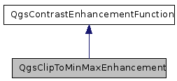
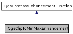
QgsClipToMinMaxEnhancement Class Reference
[QGIS core library]
A raster contrast enhancement that will clip a value to the specified min/max range.
More...
#include <qgscliptominmaxenhancement.h>


Public Member Functions | |
| QgsClipToMinMaxEnhancement (QgsContrastEnhancement::QgsRasterDataType, double, double) | |
| int | enhance (double) |
| A customizable method that takes in a double and returns a int between 0 and 255. | |
| bool | isValueInDisplayableRange (double) |
| A customicable method to indicate if the pixels is displayable. | |
Detailed Description
A raster contrast enhancement that will clip a value to the specified min/max range.For example if a min max range of [10,240] is specified in the constructor, and a value of 250 is called using enhance(), the value will be truncated ('clipped') to 240.
Definition at line 30 of file qgscliptominmaxenhancement.h.
Constructor & Destructor Documentation
| QgsClipToMinMaxEnhancement::QgsClipToMinMaxEnhancement | ( | QgsContrastEnhancement::QgsRasterDataType | theQgsRasterDataType, | |
| double | theMinimumValue, | |||
| double | theMaximumValue | |||
| ) |
Definition at line 21 of file qgscliptominmaxenhancement.cpp.
Member Function Documentation
| int QgsClipToMinMaxEnhancement::enhance | ( | double | theValue | ) | [virtual] |
A customizable method that takes in a double and returns a int between 0 and 255.
Reimplemented from QgsContrastEnhancementFunction.
Definition at line 25 of file qgscliptominmaxenhancement.cpp.
References QgsContrastEnhancement::maximumValuePossible(), QgsContrastEnhancement::minimumValuePossible(), QgsContrastEnhancementFunction::mMaximumValue, QgsContrastEnhancementFunction::mQgsRasterDataType, and QgsContrastEnhancement::QGS_Byte.
| bool QgsClipToMinMaxEnhancement::isValueInDisplayableRange | ( | double | theValue | ) | [virtual] |
A customicable method to indicate if the pixels is displayable.
Reimplemented from QgsContrastEnhancementFunction.
Definition at line 42 of file qgscliptominmaxenhancement.cpp.
References QgsContrastEnhancementFunction::mMaximumValue.
The documentation for this class was generated from the following files:
- src/core/raster/qgscliptominmaxenhancement.h
- src/core/raster/qgscliptominmaxenhancement.cpp
 1.5.6
1.5.6