QGIS dan GRASS pada Pemetaan Ancaman Kebakaran Hutan Semak Tingkat Pemerintahan Daerah
Pengenalan
The Southern Downs Regional Council (SDRC) is a small-to-medium sized local government in south east Queensland, Australia. The council region, mainly the southern part, suffers from major bushfires. Bushfire is a real and present concern for the residents and landowners in the Southern Downs Region, and has resulted in the loss of life and property.
Proyek ini diharapkan dapat menjadikan dewan dan masyarakat untuk lebih sadar terhadap resiko dan bisa mengambil keputusan yang lebih baik dimasa depan.
Mengenai Kegiatan
Sebagai permasalahan yang tidak hanya diderita oleh Southern Dawn melainkan seluruh Queensland, pemerintahan negara bagian menginstruksikan setiap pemerintahan daerah untuk mengidentifikasi ancaman kebakaran semak diwilayah masing-masing melalui Peraturan Perencanaan Negara Bagian 1/03 Mitigasi Dampak Kerugian oleh Ancaman Banjir, Kebakaran Semak dan Tanah Longsor [1] (State Planning Policy 1/03 Mitigating the Adverse Impacts of Flood, Bushfire and Landslide [1]). Pekerjaan ini seharusnya dilaksanakan oleh para konsultan, akan tetapi yang melakukan adalah dari pihak dewan sendiri dengan bantuan kombinasi penggunaan QGIS dan GRASS.
Tahapan SIG dari kegiatan ini dibagi menjadi 6 tahapan utama
Pemetaan dan Penilaian Kelerangan
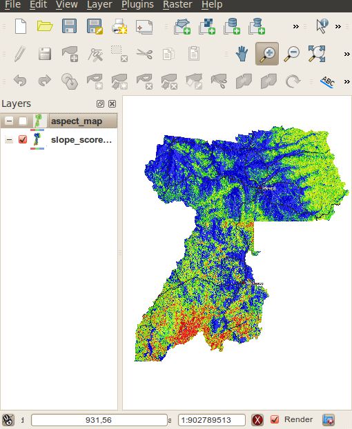
Pemetaan dan Penilaian Arah Kelerangan (Aspect)
Pemetaan dan Penilaian Vegetasi
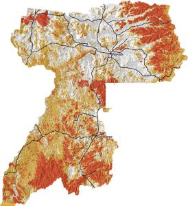
Mengkombinasikan nilai untuk mengidentifikasi tingkatan ancaman kebakaran semak
Verifikasi lapangan dan penilaian kualitatif
Peta Akhir
Penggunaan QGIS dan GRASS
QGIS, using the GRASS plugin, was selected as it provided the tools needed to complete the job and the interaction between QGIS and GRASS made it easy to process the raster maps and present them in a meaningful way to users. SDRC uses MapInfo for its main GIS system, however MapInfo’s addons were not as powerful as GRASS GIS for raster processing.
The QGIS GRASS plugin was used to import 5 meter contours of the whole region into GRASS which were then converted into a contour raster map using r.surf.contour. A slope and aspect map were then generated using r.slope.aspect from the raster contour map. Categories were assigned to different slope and aspect ranges and given a hazard risk sore. Vegetation areas were also given different risk scores. All the resulting raster maps were then combined using mapcalc and given a final risk hazard score. The risk scores are then divided into three main categories: high; medium; and low.
The final part of the process was field verification via the rural fire service. After the review process, QGIS was used to print the final maps for presentation.
As all GRASS commands can be run from the command line, all the commands that were needed to generate the bushfire hazard maps were recorded, for documentation purposes and for if the maps needed to be regenerated some time in the future.
Kesimpulan
Overall QGIS, together with the GRASS plugin, provided a great experience and a great final outcome for the council doing their own bushfire hazard mapping. The GRASS plugin provides a very easy to use interface to GRASS through QGIS. As QGIS is able to open the GRASS raster format natively, integration is very seamless and maps can be made with ease.
Proyek ini memenangkan encouragement award pada Queensland Planning Institute of Australia Planning Awards di tahun 2010 [2]
Daftar Pustaka
[2]http://digital.crowtherblayne.com.au/default.aspx?xml=crowther_pia.xml
Penulis

Nathan Woodrow
Artikel ini ditulis pada bulan Januari 2011 oleh Natha Woodrow. Ia adalah seorang petugas SIG pada SDRC dan saat ini sedang melanjutkan studi pada Spatial Science di University of Souther Queensland